donsutherland1
-
Posts
23,765 -
Joined
Content Type
Profiles
Blogs
Forums
American Weather
Media Demo
Store
Gallery
Everything posted by donsutherland1
-
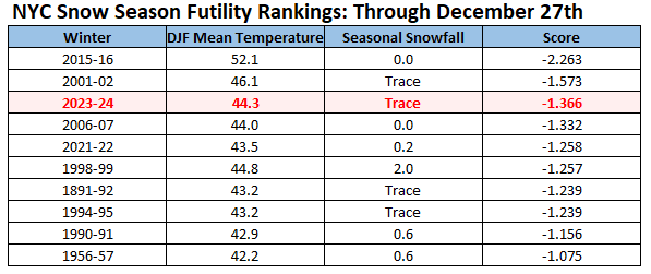
In terms of cold, Winter 1917-18 ranks first (2.5 sigma below the historic mean). Winter 1880-81 ranks second (2.2 sigma). Winter 1917-18 only had slightly above normal snowfall, which brought its overall ranking to 9th on a standardized winter temperature-seasonal snowfall basis.
-
NYC won't reach double digits this month. JFK has 52.54" of precipitation this year as of 8:35 am.
-
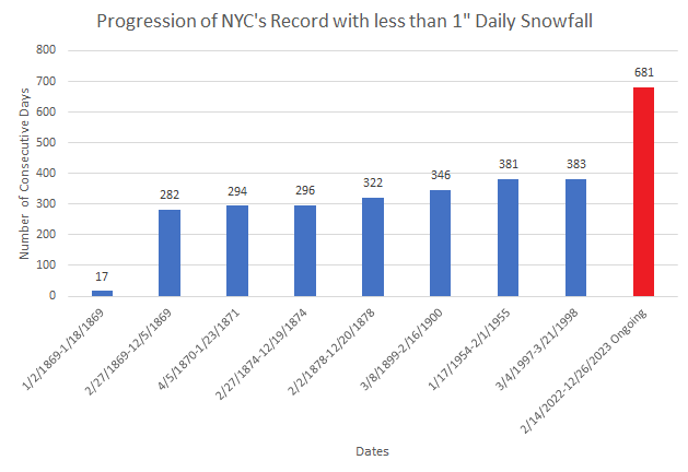
New York City's ongoing less than 1" daily snowfall drought will reach 683 days today. That will exceed the old record by 300 days.

-
Its final score was 1st (27.7° winter mean temperature and 60.3" of snow). 1995-96 was first in snowfall but second overall, as it was a much warmer winter than 1872-73.
-
ABE has already broken its old monthly record of 7.89” from 1973.
-
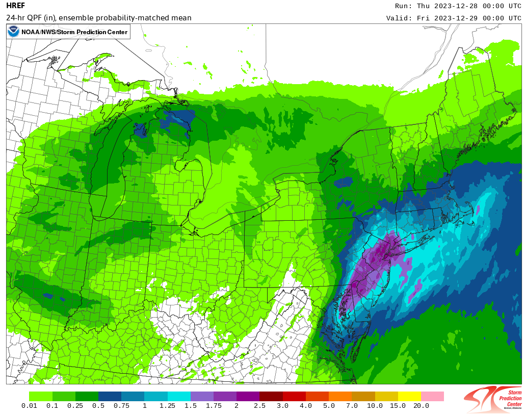
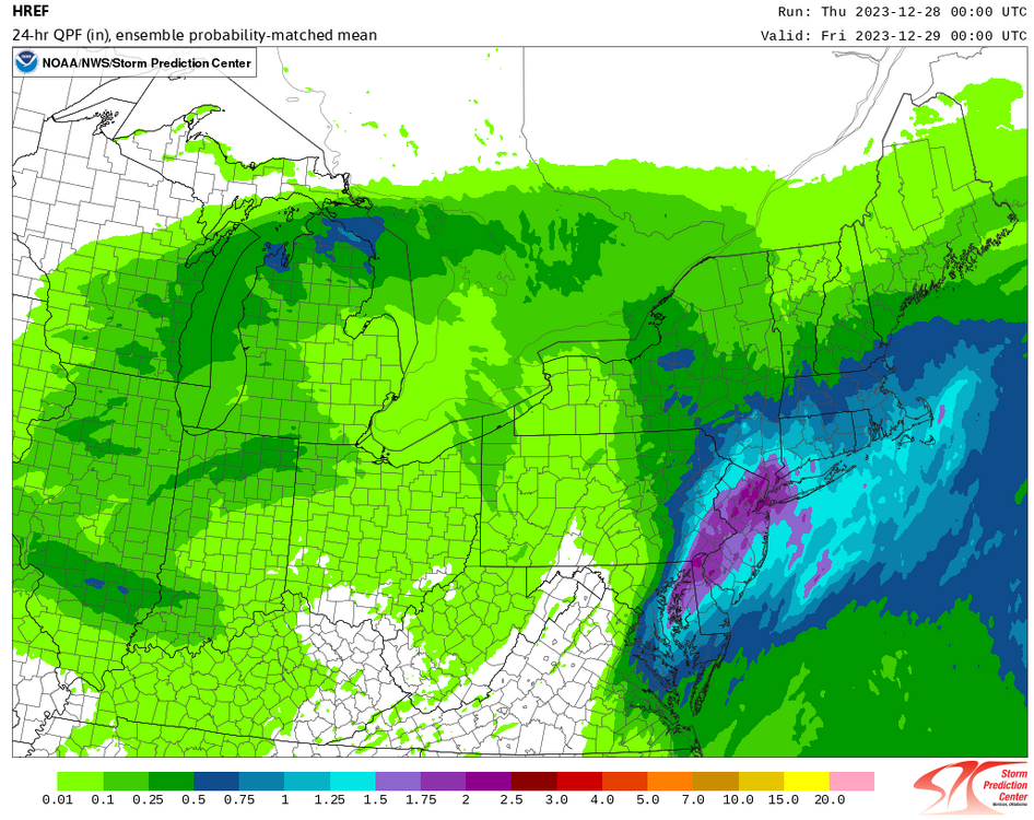
Rainfall totals for December 27th through 11:25 pm include: Allentown: 1.87" (old record: 1.55", 1930) Baltimore: 1.63" (old record: 1.21", 1894) Philadelphia: 1.23" Washington, DC: 1.20" (old record: 1.16", 1894) Wilmington, DE: 1.79" (old record: 1.76", 1930) Guidance and the upstream rainfall totals above suggest that the New York City area remains on track for a general 1.00"-2.00" rainfall with locally higher amounts.
-
Latest HREF: Should NYC see 1"-2" of rain, 2023 will rank as the 11th wettest year on record. Records go back to 1869.
-
Through December 27th, Winter 1872-1873 ranked best in terms of the combination of cold (27.3° mean temperature) and snowfall (26.8") to date.
-
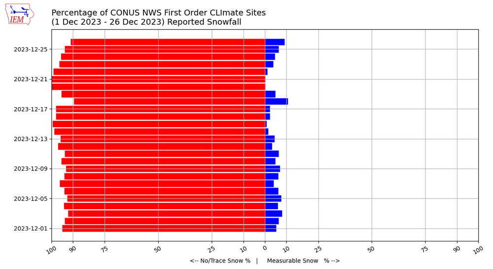
On December 26, 2023, 91% of NWS first order sites had below normal snowfall:
-
Overnight, temperatures will hold steady or slowly rise reaching the lower 50s in many parts of the region. Tomorrow and Friday will be very mild days. The unseasonably mild weather will likely continue through the remainder of December. Light rain will become steadier and heavier tonight. The rain will continue through much of tomorrow before tapering off to showers tomorrow night. Additional showers are possible on Friday. A general 1.00"-2.00" rainfall with some locally higher amounts in excess of 3.00" is likely across the region. Somewhat colder air should begin moving into the region to close December. The first week of January will likely feature somewhat below normal temperatures. However, severe cold appears unlikely. Initially, the arrival of a colder regime could coincide with a drier one, so snowfall prospects will remain limited. The second week of January could offer better opportunities for snowfall, as the retreat of cold air could occur as the pattern becomes wetter. There remains some uncertainty concerning the magnitude and duration of the colder period that could develop. At this time, it appears more likely than not that it will be seasonably cold or somewhat colder than normal with a duration of 1-2 weeks. The ENSO Region 1+2 anomaly was +1.6°C and the Region 3.4 anomaly was +2.0°C for the week centered around December 20. For the past six weeks, the ENSO Region 1+2 anomaly has averaged +1.75°C and the ENSO Region 3.4 anomaly has averaged +1.98°C. A basinwide El Niño event is ongoing. El Niño conditions may strengthen somewhat further this month. The SOI was +0.67 on December 26. The preliminary Arctic Oscillation (AO) was -0.717 today. Strong blocking in the final week of November, as occurred this year, has often been followed by frequent blocking in December and January. Atlantic blocking is continuing to redevelop. On December 25 the MJO was in Phase 1 at an amplitude of 1.774 (RMM). The December 24-adjusted amplitude was 1.451 (RMM). Based on sensitivity analysis applied to the latest guidance, there is an implied near 100% probability that New York City will have a warmer than normal December (1991-2020 normal). December will likely finish with a mean temperature near 44.4° (5.3° above normal). That would make December 2023 the 2nd warmest December on record. With 2023 virtually certain to be among the 10 warmest Decembers on record, 60% of New York City's 10 warmest Decembers have occurred since 2000, including 40% since 2010, and all have occurred since 1980. Records go back to 1869.
-
That's the last time I can recall seeing some of it.
-
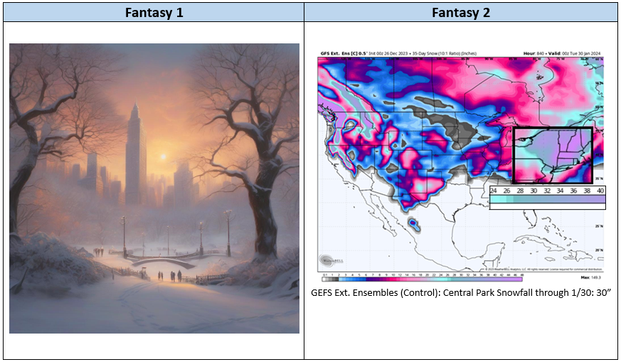
The GEFS 35-days Ensemble Control snowfall map was posted on Twitter/X this morning. That raises the following question: What is the difference between Fantasy 1 and Fantasy 2? Fantasy 1 exists only in the virtual realm thanks to AI. Fantasy 2 will almost certainly disappear with the passage of time. Only a single January has seen 30" or more snowfall in Central Park (2011: 36.0") and just four months since January 1869 have seen 30" or more snowfall.
-
I pulled the data and then checked for consecutive days.
-
Although I am not aware of records being kept on fog specifically, the record stretch of days for visibility falling below 1 mile at Islip is 9 days: June 20-28, 1973.
-
It should be noted that the 20-30 days DT references would not immediately follow the SSWE. There’s usually a 2-4-week lag. The ongoing return of Atlantic blocking precedes the SSWE, it is not the result of an event that has not yet occurred. There is some chatter on social media that there won’t be much of a lag. That is wrong. These events take time to propagate into the troposphere and, thereby, influence synoptic patterns. For an illustration, consider a case where one throws a pebble into the center of a calm pond. It takes time for the ripples to reach shore. If, almost simultaneously to the pebble's being tossed into the center of the pond, an acorn falls from a tree near shore and its ripples arrive much sooner than those from the pebble, one can't attribute those ripples to that of the pebble. The same holds true regarding the redevelopment of blocking, which actually precedes the start of the SSWE.
-
The temperature topped out at 51° in New York City's Central Park and 50° in Philadelphia today despite mainly cloudy and misty conditions. This unseasonably mild weather is likely through the remainder of December. Rain will arrive late tomorrow and tomorrow night. That rain will likely continue through much of Thursday before tapering off to showers Thursday night or Friday. A general 1.00"-2.00" rainfall with some locally higher amounts is likely across the region. A transition to a colder pattern lies ahead. Somewhat colder air should begin moving into the region to close December. The first week of January will likely feature somewhat below normal temperatures. However, severe cold appears unlikely. Initially, the arrival of a colder regime could coincide with a drier one. The second week of January could offer better opportunities for snowfall, as the retreat of cold air could occur as the pattern becomes wetter. There remains some uncertainty concerning the magnitude and duration of the colder period that could develop. At this time, it appears more likely than not that it will be seasonably cold or somewhat colder than normal with a duration of 1-2 weeks. The ENSO Region 1+2 anomaly was +1.6°C and the Region 3.4 anomaly was +2.0°C for the week centered around December 20. For the past six weeks, the ENSO Region 1+2 anomaly has averaged +1.75°C and the ENSO Region 3.4 anomaly has averaged +1.98°C. A basinwide El Niño event is ongoing. El Niño conditions may strengthen somewhat further this month. The SOI was not available today. The preliminary Arctic Oscillation (AO) was -0.089 today. Strong blocking in the final week of November, as occurred this year, has often been followed by frequent blocking in December and January. Atlantic blocking is redeveloping. On December 24 the MJO was in Phase 1 at an amplitude of 1.451 (RMM). The December 23-adjusted amplitude was 1.303 (RMM). Based on sensitivity analysis applied to the latest guidance, there is an implied near 100% probability that New York City will have a warmer than normal December (1991-2020 normal). December will likely finish with a mean temperature near 44.2° (5.1° above normal). That would make December 2023 the 2nd warmest December on record. With 2023 virtually certain to be among the 10 warmest Decembers on record, 60% of New York City's 10 warmest Decembers have occurred since 2000, including 40% since 2010, and all have occurred since 1980. Records go back to 1869.
-
The absence of measurable snow, the growing weight of the longest 1" and 2" daily snowfall droughts on record, and the prospect that December 2023 could become New York City's second warmest December on record have taken a toll. New York City isn't alone. Misery loves company. Misery has company. Baltimore and Philadelphia are suffering through their longest stretches on record without 1" or more daily snowfall. Green Bay recorded its 3rd consecutive 50° high temperature this morning, which will exceed the Green Bay Packers' longest December winning streak this year. It also beats the latest-season such occurrence of such warmth (December 7-9, 1946) by more than two weeks. December 2023 will easily surpass December 2015 as Milwaukee's warmest December on record. Even if Baltimore, Boston, Bridgeport, New York City, Newark, Philadelphia, Providence, Richmond and Washington, DC pool all their snowfall to date, they can't come up with an inch of the precious frozen water. Nevertheless, the pattern will change for the first week of January. It will turn seasonably cold to somewhat colder than normal in the Northeast. To those psychologically scarred by December's terrible combination of warmth, lack of snowfall, and failed social media prophesies of imminent, sustained, deep cold, this change might not seem like much. To some, it might not even be noticeable. But it will be real. Initially, things will be dry. But as the relatively short-duration "chill" begins to depart, a wetter pattern could develop. Perhaps, the timing might be just right to allow for the kind of widespread measurable snow event that has yet to occur this late-starting winter. The longer-term outlook will depend on factors such as the possible development of a sudden stratospheric warming event (even if not major), the evolution of the ongoing strong El Niño event, and distortionary effects of ongoing marine heatwaves. The effects of the potential sudden stratospheric warming event might begin to impact the region in the closing days of January and into the start of February. That period has often been a favorable one in ENSO climatology. Unlike in past years where 10 mb maps are used to proclaim anything that looks like a warming as a coming sudden stratsopheric warming event, the upcoming event looks real and has strong ensemble support. For now, one's patience will be tried. The siren call of social medial prophesy of imminent outbreaks of severe cold and great snowstorms (often coupled with end-of-range CFSv2 maps or GFS operational runs) will create the kind of noise that makes the pain even greater. Temptations to rush the effects of the sudden stratospheric warming event, which typically take 2-4 weeks to start to unfold, could be another aggravating factor. For now, the focus should be on what's just ahead: the short-duration cooler but not cold pattern to start 2024. Perhaps it could afford some opportunity for snowfall before it gives way to another mild period. Historically, New York City has never seen two consecutive seasons with less than 10" of snow. Moreover, the least snowfall over two seasons is the 15.5" total that fell during 1996-97 and 1997-98.
-
Evening thoughts: Pattern change still on track: A storm will bring a general 0.50"-1.50" rainfall with some locally higher amounts Wednesday into Thursday. Behind the storm cooler air will begin to move into the region. The last two days of December should see readings that are close to normal. Nevertheless, the region will have experienced an exceptionally warm December (NYC remains on a trajectory that could see it wind up with its 3rd warmest December on record). The first week of January will likely feature somewhat below normal readings with Atlantic blocking having redeveloped. Severe cold is unlikely. The ECMWF weeklies and CFSv2 weeklies are also in good agreement. However, that week could wind up drier than normal leading to opportunities for only smaller snowfall amounts. Historic experience following cases where the AO reached +3.000 or above during December 15-25 have typically seen only light snow events through January 10th. January 2014 when 6.4" of snow fell in NYC is an exception. The second week of January could see the cold begin to retreat and the trough's possible redevelopment in the West. The pattern could also grow wetter. The region could have its best opportunity for widespread snowfall so far this winter before the cold air departs. However, that timeframe is too far out for specifics. Beyond that, the evolution of the MJO and the possible development of a sudden stratospheric warming event (SSWE) will be among the important factors that drive the pattern evolution. MJO forecasts at that range have almost no skill. Disagreements also exist among the guidance concerning the MJO. Should the SSWE occur, which appears more likely than not, the polar vortex could split. Should the largest piece migrate to Eurasia, Eurasia would see the largest area of cold. However, even a smaller piece could allow North America to experience cold of a magnitude that has not yet occurred this winter. Whether that piece would dig into the West or move into eastern North America is uncertain from this far out. The downstream effects of any SSWE could align well with peak ENSO climatalogy for cold and snow.
-
Minneapolis reached 54° today, breaking the daily record of 51° that was set in 1922. That followed yesterday's daily record high of 55°. This is the latest-season occurrence of two consecutive high temperatures of 54° or above. The previous record was set during December 6-7, 1939. Some of this milder air will be moving into the Middle Atlantic and southern New England regions. As a result, unseasonably mild weather is likely through the middle of the week. Generally warmer than normal conditions will likely prevail through most of the remainder of December. A transition to a colder pattern lies ahead. Somewhat colder air should begin moving into the region to close December. The first week of January will likely feature somewhat below normal temperatures. However, severe cold appears unlikely. Initially, the arrival of a colder regime could coincide with a drier one. The second week of January could offer better opportunities for snowfall, as the retreat of cold air could occur as the pattern becomes wetter. There remains some uncertainty concerning the magnitude and duration of the colder period that could develop. At this time, it appears more likely than not that it will be seasonably cold or somewhat colder than normal with a duration of 1-2 weeks. The ENSO Region 1+2 anomaly was +1.5°C and the Region 3.4 anomaly was +2.0°C for the week centered around December 13. For the past six weeks, the ENSO Region 1+2 anomaly has averaged +1.85°C and the ENSO Region 3.4 anomaly has averaged +1.95°C. A basinwide El Niño event is ongoing. El Niño conditions may strengthen somewhat further this month. The SOI was -9.13 today. The preliminary Arctic Oscillation (AO) was +0.340 today. Strong blocking in the final week of November, as occurred this year, has often been followed by frequent blocking in December and January. The latest GEFS shows a return to Atlantic blocking. On December 23 the MJO was in Phase 1 at an amplitude of 1.303 (RMM). The December 22-adjusted amplitude was 0.894 (RMM). Based on sensitivity analysis applied to the latest guidance, there is an implied near 100% probability that New York City will have a warmer than normal December (1991-2020 normal). December will likely finish with a mean temperature near 43.8° (4.7° above normal). That would tie December 2023 with December 2021 as the 3rd warmest December on record. With 2023 virtually certain to be among the 10 warmest Decembers on record, 60% of New York City's 10 warmest Decembers have occurred since 2000, including 40% since 2010, and all have occurred since 1980. Records go back to 1869.
-
GFS, please give us a white Christmas: No success. We're not 384 hours out. AI, please give us a white Christmas: For now, AI grants such wishes. But that may change in the future. Then, as AI "learns" the realities of the New York City area climate, it may well deny such requests. Last White Christmas in NYC: 2009.

-
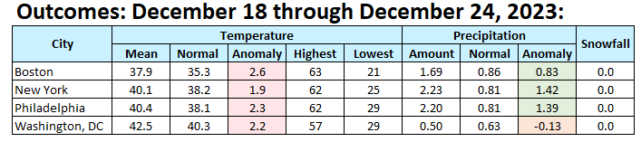
The final numbers for the past week.

-
An exceptionally mild December rolls on. Tomorrow will be mainly cloudy and mild. Temperatures will likely reach 50° in much of the region. Even milder weather is likely through the middle of the week. Generally warmer than normal conditions will likely prevail through most of the remainder of December. A transition to a colder pattern lies ahead. Somewhat colder air should begin moving into the region to close December. The first week of January will likely feature somewhat below normal temperatures. However, severe cold appears unlikely. Initially, the arrival of a colder regime could coincide with a drier one. There remains some uncertainty concerning the magnitude and duration of the colder period that could develop. At this time, it appears more likely than not that it will be seasonably cold or somewhat colder than normal with a duration of 1-2 weeks. The ENSO Region 1+2 anomaly was +1.5°C and the Region 3.4 anomaly was +2.0°C for the week centered around December 13. For the past six weeks, the ENSO Region 1+2 anomaly has averaged +1.85°C and the ENSO Region 3.4 anomaly has averaged +1.95°C. A basinwide El Niño event is ongoing. El Niño conditions may strengthen somewhat further this month. The SOI was -27.25 today. The preliminary Arctic Oscillation (AO) was +0.732 today. Strong blocking in the final week of November, as occurred this year, has often been followed by frequent blocking in December and January. The latest GEFS shows a return to Atlantic blocking. On December 22 the MJO was in Phase 8 at an amplitude of 0.894 (RMM). The December 21-adjusted amplitude was 0.722 (RMM). Based on sensitivity analysis applied to the latest guidance, there is an implied near 100% probability that New York City will have a warmer than normal December (1991-2020 normal). December will likely finish with a mean temperature near 43.8° (4.7° above normal). That would tie December 2023 with December 2021 as the 3rd warmest December on record. With 2023 virtually certain to be among the 10 warmest Decembers on record, 60% of New York City's 10 warmest Decembers have occurred since 2000, including 40% since 2010, and all have occurred since 1980. Records go back to 1869.
-
It's already snowing lightly in such areas ad North Platte and Valentine. The latter could see more than a foot of wind-blown snow. A blizzard warning is in effect. Light rain will change to heavy snow in parts of South Dakota where the blizzard is also expected to bring heavy snow.
-
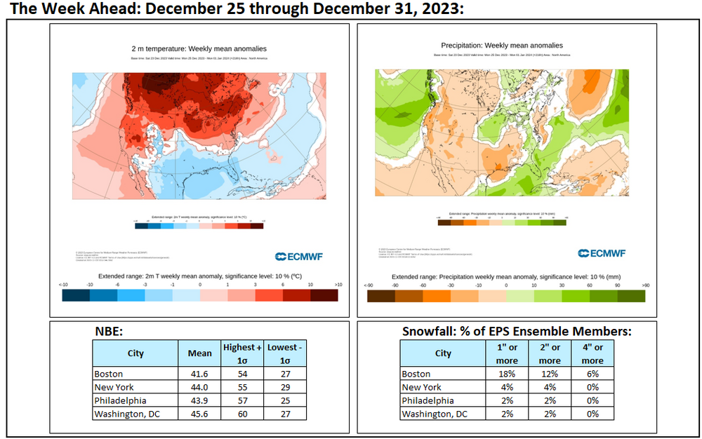
Some week ahead maps and numbers. Cooler air moves in near the end of the month. Prospects for snowfall remain low.
-
Generally warmer than normal conditions will likely prevail through most of the remainder of December. A transition to a colder pattern will likely commence during the first week of January. Severe cold appears unlikely early in the transition. There remains uncertainty concerning the magnitude and duration of the colder period that could develop. At this time, it appears more likely than not that it will be seasonably cold or somewhat colder than normal with a duration of 1-2 weeks. Initially, the arrival of a colder regime could coincide with a drier one. The ENSO Region 1+2 anomaly was +1.5°C and the Region 3.4 anomaly was +2.0°C for the week centered around December 13. For the past six weeks, the ENSO Region 1+2 anomaly has averaged +1.85°C and the ENSO Region 3.4 anomaly has averaged +1.95°C. A basinwide El Niño event is ongoing. El Niño conditions may strengthen somewhat further this month. The SOI was -36.43 today. The preliminary Arctic Oscillation (AO) was +1.055 today. Strong blocking in the final week of November, as occurred this year, has often been followed by frequent blocking in December and January. Therefore, blocking will likely return in January, if historic experience is representative. The latest GEFS shows a return to Atlantic blocking. On December 21 the MJO was in Phase 7 at an amplitude of 0.722 (RMM). The December 20-adjusted amplitude was 0.834 (RMM). Based on sensitivity analysis applied to the latest guidance, there is an implied near 100% probability that New York City will have a warmer than normal December (1991-2020 normal). December will likely finish with a mean temperature near 43.5° (4.4° above normal). That would make December 2023 the 6th warmest December on record.