donsutherland1
-
Posts
23,765 -
Joined
Content Type
Profiles
Blogs
Forums
American Weather
Media Demo
Store
Gallery
Everything posted by donsutherland1
-
The coolest air mass so far this season covers the region. New York City saw the temperature fall to 57° this morning, its first August low in the 50s since August 15, 2013 when the thermometer fell to 59°. That was also the coolest August reading since August 22, 2007 when the temperature bottomed out at 56°. Low temperatures included: Atlantic City: 50° Baltimore: 53° Boston: 58° Bridgeport: 55° Danbury: 49° Islip: 54° New Haven: 55° New York City-Central Park: 57° New York City-JFK Airport: 58° New York City-LaGuardia Airport: 59° Newark: 57° Philadelphia: 57° Poughkeepsie: 48° Sterling, VA: 50° Trenton: 52° Washington, DC: 59° Westhampton: 46° White Plains: 55° Wilmington, DE: 52° Tomorrow morning could again see the temperature fall into the 50s in New York City. Highs will reach the lower to middle 70s in the City. Friday will become somewhat milder. A warmer pattern will likely develop during the weekend. Temperatures could briefly reach much above normal levels in the closing days of August. Out West, cities such as Flagstaff, Las Vegas, and Phoenix remain on track for their hottest summer on record. Del Rio is in the midst of its record third extreme heat event (Clarke et al., 2014 framework) of the year. High temperature records fell in parts of Texas. Highs through 6:30 pm EDT included: Abilene: 113° (old record: 106°, 2023) ***New all-time record*** Austin: 109° (old record: 107°, 1925) Brownsville: 102° (old record: 99°, 1896, 1918 and 1991) Corpus Christi: 105° (old record: 100°, 1997 and 2023) Del Rio: 112° (old record: 109°, 2023) ***New August Record*** McAllen: 105° (old record: 103°, 1997 and 2018) San Angelo: 111° (old record: 107°, 2023) ***Tied August record*** San Antonio: 108° (old record: 105°, 2023) The ENSO Region 1+2 anomaly was 0.0°C and the Region 3.4 anomaly was -0.1°C for the week centered around August 14. For the past six weeks, the ENSO Region 1+2 anomaly has averaged -0.33°C and the ENSO Region 3.4 anomaly has averaged +0.05°C. Neutral ENSO conditions will likely evolve into a La Niña event during the fall. The SOI was +18.57 today. The preliminary Arctic Oscillation (AO) was +1.490 today. Based on sensitivity analysis applied to the latest guidance, there is an implied 65% probability that New York City will have a cooler than normal August (1991-2020 normal). August will likely finish with a mean temperature near 75.5° (0.6° below normal).
- 1,764 replies
-
- 1
-

-
- hurricanes
- tropics
- (and 5 more)
-
The coolest air mass so far this season has been pushing into the region. New York City will see the mercury dip below 60° for the first time since June 11th tomorrow morning. The last time the temperature fell below 60° in August in New York City was August 15, 2013 when the thermometer fell to 59°. The current air mass is somewhat colder than that and the potential exists for the temperature to fall to its lowest level in August since August 22, 2007 when the temperature bottomed out at 56°. Some outlying areas could see the temperature fall into the 40s. Thursday morning could again see the temperature fall toward or below 60° in New York City. Highs both days will be in the lower to middle 70s in the City. A warmer pattern will likely develop starting next weekend. Out West, cities such as Flagstaff, Las Vegas, and Phoenix remain on track for their hottest summer on record. Del Rio is in the midst of its record third extreme heat event (Clarke et al., 2014 framework) of the year. The temperature could make a run at the August monthly record on Wednesday and Thursday at Del Rio. The ENSO Region 1+2 anomaly was -0.2°C and the Region 3.4 anomaly was 0.0°C for the week centered around August 7. For the past six weeks, the ENSO Region 1+2 anomaly has averaged -0.33°C and the ENSO Region 3.4 anomaly has averaged +0.12°C. Neutral ENSO conditions will likely evolve into a La Niña event during the early fall. The SOI was +28.10 today. The preliminary Arctic Oscillation (AO) was +1.428 today. Based on sensitivity analysis applied to the latest guidance, there is an implied 60% probability that New York City will have a cooler than normal August (1991-2020 normal). August will likely finish with a mean temperature near 75.6° (0.5° below normal).
-
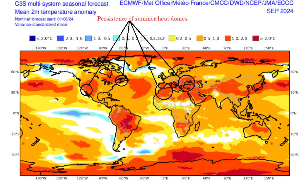
The C3S multi-model suite shows several areas of persistent summer heat domes will predominate in September.

- 1,764 replies
-
- 2
-
-

-
- hurricanes
- tropics
- (and 5 more)
-
A shower or thundershower is possible this evening as a cold front moves across the region. Behind the front, the coolest air mass so far this season will begin to overspread the region tomorrow. Temperatures will top out in the lower to perhaps middle 70s as clouds give way to sunshine. Afterward, New York City will likely see the mercury dip below 60° for the first time since June 11th on Wednesday morning. Thursday morning could again see the temperature fall toward or below 60° in New York City. Highs both days will be in the lower to middle 70s in the City. A warmer pattern will likely develop starting next weekend. Out West, cities such as Flagstaff, Las Vegas, and Phoenix remain on track for their hottest summer on record. Denver recently experienced its third extreme heat event (Clarke et al., 2014 framework) of the year setting a new annual record. Del Rio is in the midst of its record third extreme heat event of the year. The heat there will intensify with the temperature making a run at the August monthly record on Wednesday and Thursday. The ENSO Region 1+2 anomaly was -0.2°C and the Region 3.4 anomaly was 0.0°C for the week centered around August 7. For the past six weeks, the ENSO Region 1+2 anomaly has averaged -0.33°C and the ENSO Region 3.4 anomaly has averaged +0.12°C. Neutral ENSO conditions will likely evolve into a La Niña event during the early fall. The SOI was +20.15 today. The preliminary Arctic Oscillation (AO) was +1.746 today. Based on sensitivity analysis applied to the latest guidance, there is an implied 56% probability that New York City will have a cooler than normal August (1991-2020 normal). August will likely finish with a mean temperature near 75.7° (0.4° below normal).
- 1,764 replies
-
- 1
-
-
- hurricanes
- tropics
- (and 5 more)
-
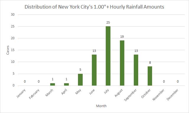
During the past hour, New York City received 1.12" of rain. 22 or 19% of the City's hourly 1.00"+ cases have occurred in August.
- 1,764 replies
-
- 1
-
-
- hurricanes
- tropics
- (and 5 more)
-
The remnants of Debby earlier this month fundamentally reoriented the eastern North America pattern. The end result has been a much cooler scenario that has put August on a path that could lead to a cooler than normal monthly outcome. Heavy rain brought flooding to parts of the region today. In the nearby New York City suburbs, New Rochelle picked up 3.14" of rain. Fairfield County saw the heaviest rainfall with 6"-10" amounts recorded through 6 pm. Additional heavy rain is possible in thunderstorms that could affect parts of the region this evening into tonight. After a mild start to the work week tomorrow, the coolest air mass so far this season will move into the region. There is a possibility that even New York City could see the mercury dip below 60° for the first time since June 11th during midweek. A warmer pattern could develop starting next weekend. Out West, cities such as Flagstaff, Las Vegas, and Phoenix remain on track for their hottest summer on record. Denver recently experienced its third extreme heat event (Clarke et al., 2014 framework) of the year setting a new annual record. Del Rio is in the midst of its record third extreme heat event of the year. The ENSO Region 1+2 anomaly was -0.2°C and the Region 3.4 anomaly was 0.0°C for the week centered around August 7. For the past six weeks, the ENSO Region 1+2 anomaly has averaged -0.33°C and the ENSO Region 3.4 anomaly has averaged +0.12°C. Neutral ENSO conditions will likely evolve into a La Niña event during the early fall. The SOI was +21.00 today. The preliminary Arctic Oscillation (AO) was +1.608 today. Based on sensitivity analysis applied to the latest guidance, there is an implied 57% probability that New York City will have a cooler than normal August (1991-2020 normal). August will likely finish with a mean temperature near 75.6° (0.5° below normal).
- 1,764 replies
-
- 1
-
-
- hurricanes
- tropics
- (and 5 more)
-
Phoenix's record lasted for one year. July 2024 saw the temperature average 103.2° at Needles, CA.
-
Phoenix Experiences its Hottest June on Record
donsutherland1 replied to donsutherland1's topic in Climate Change
Phoenix has been rewriting is record book, especially since 2020. -
Phoenix Experiences its Hottest June on Record
donsutherland1 replied to donsutherland1's topic in Climate Change
Phoenix’s record streak of 80-degree lows ended today.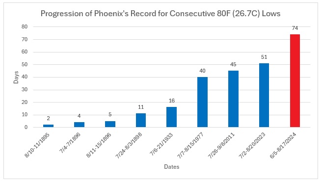
-
Islip was 88. No intra-hour high temperature data is available for JFK, yet.
- 1,764 replies
-
- 1
-

-
- hurricanes
- tropics
- (and 5 more)
-
Occasional Thoughts on Climate Change
donsutherland1 replied to donsutherland1's topic in Climate Change
Such commentary only shows that May does not understand the concept of a mean or average, even as it’s one of the most basic elements of statistics. -
When thunder roars…
-
Fordham picked up 5.38” of rain. Bogota, NJ with 5.47” has the highest amount so far.
- 527 replies
-
- 1
-
-
- flash flooding
- river flooding
- (and 2 more)
-
Street flooding in the New Rochelle, Larchmont, Mamaroneck areas is occurring.
-
The 1.41” of hourly rainfall from earlier this afternoon at Islip was the 10th highest amount on record for the summer.
- 527 replies
-
- 3
-
-
- flash flooding
- river flooding
- (and 2 more)
-
I will miss Debby’s remnants as I am out of town.

-
Phoenix Experiences its Hottest June on Record
donsutherland1 replied to donsutherland1's topic in Climate Change
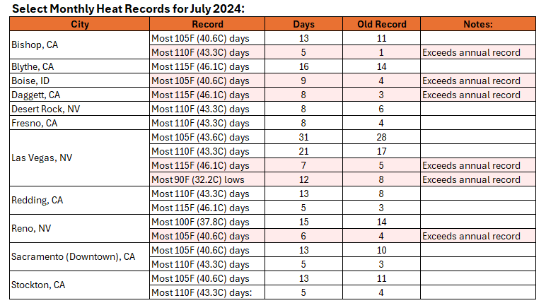
Phoenix had its second hottest July and month on record. It tied the July and monthly records for most 100° highs, 80° lows, and 90° lows. For the first time, it experienced 31 100° high temperatures following a June with 30 100° high temperatures. Through July 31st, it had an ongoing streak of 51 consecutive 80° or above low temperatures (old record: 51 days, July 1-August 20, 2023). Its ongoing streak of 66 consecutive 100° highs ranked as the second longest on record. It ended July with a streak of 57 consecutive 105° or above highs (old record: 56 days, June 24-August 18, 2023). Numerous Western cities saw their hottest July and month on record.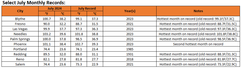
-
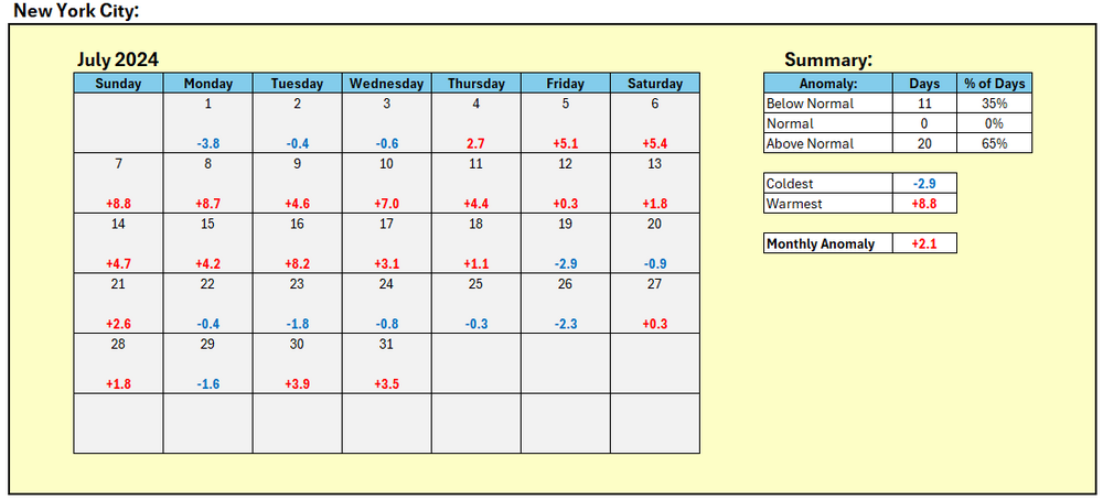
New York City's final mean temperature for July: 79.6° (2.1° above normal).
-
July finished with a preliminary mean temperature of 79.7° in New York City. That was 2.2° above normal. Tomorrow will be variably cloudy. Some showers and thunderstorms are possible. Heat will likely return during the first week in August. The latest summer guidance continues to suggest a warmer to much warmer than normal summer lies ahead. The extended range guidance continues to suggest that August will likely be warmer than normal. However, there is a possibility that the second week of the month could feature a cool shot. The ENSO Region 1+2 anomaly was -0.7°C and the Region 3.4 anomaly was 0.1°C for the week centered around July 24. For the past six weeks, the ENSO Region 1+2 anomaly has averaged -0.48°C and the ENSO Region 3.4 anomaly has averaged +0.27°C. Neutral ENSO conditions will likely evolve into a La Niña event during the early fall. The SOI was -23.33 today. The preliminary Arctic Oscillation (AO) was +0.407 today. This will be the last discussion until after mid-August.
-
August 2024 temperature forecast contest
donsutherland1 replied to Roger Smith's topic in Weather Forecasting and Discussion
DCA _ NYC _ BOS __ ORD _ ATL _ IAH __ DEN _ PHX _ SEA 1.5 1.5 1.5 1.2 1.1 0.4 2.7 2.8 2.9 -
Tomorrow will be variably cloudy. Some showers and thunderstorms are possible. Heat will likely return during the first week in August. The latest summer guidance continues to suggest a warmer to much warmer than normal summer lies ahead. The extended range guidance continues to suggest that August will likely be warmer than normal. The ENSO Region 1+2 anomaly was -0.7°C and the Region 3.4 anomaly was 0.1°C for the week centered around July 24. For the past six weeks, the ENSO Region 1+2 anomaly has averaged -0.48°C and the ENSO Region 3.4 anomaly has averaged +0.27°C. Neutral ENSO conditions will likely evolve into a La Niña event during the early fall. The SOI was -23.33 today. The preliminary Arctic Oscillation (AO) was +0.842 today. Based on sensitivity analysis applied to the latest guidance, there is an implied near 100% probability that New York City will have a warmer than normal July (1991-2020 normal). July will likely finish with a mean temperature near 79.6° (2.1° above normal).
-
Generally near normal readings will prevail through the remainder of July. An offshore system will continue to bring periodic clouds and showers tomorrow into Wednesday. Steadier rain is possible on Wednesday. Eastern New England and Long Island will likely see the highest rainfall amounts. Heat will likely return during the first week in August. The latest summer guidance continues to suggest a warmer to much warmer than normal summer lies ahead. The extended range guidance suggests that August will likely be warmer than normal. The ENSO Region 1+2 anomaly was -0.7°C and the Region 3.4 anomaly was 0.1°C for the week centered around July 24. For the past six weeks, the ENSO Region 1+2 anomaly has averaged -0.48°C and the ENSO Region 3.4 anomaly has averaged +0.27°C. Neutral ENSO conditions will likely evolve into a La Niña event during the early fall. The SOI was -23.45 today. The preliminary Arctic Oscillation (AO) was +0.858 today. Based on sensitivity analysis applied to the latest guidance, there is an implied near 100% probability that New York City will have a warmer than normal July (1991-2020 normal). July will likely finish with a mean temperature near 79.5° (2.0° above normal).
-
Occasional Thoughts on Climate Change
donsutherland1 replied to donsutherland1's topic in Climate Change
It seems as if with temperatures, his analysis is superficial and overly simplistic. He saw the larger extent and immediately assumed that the ice was recovering. He never considered thickness (old thick sea ice is very low). Thus, when conditions warmed, the illusory gains in extent quickly disappeared as the thin ice began melting away. Arctic sea ice extent is now the third lowest on record (JAXA) as of July 28th. -
Occasional Thoughts on Climate Change
donsutherland1 replied to donsutherland1's topic in Climate Change
The flaw in Martz's analysis is that the frequency of records (cold and warm) should decrease over time, as records become more difficult to break. Yet, following the Dust Bowl era the frequency of high temperature records has remained relatively stable (not shown is the decrease in cold records). Moreover, in a stable climate, the ratio of record highs and lows should be close to 1:1. Instead, the proportion of record highs to record lows has increased. The rising ratio of record highs to record lows is consistent with a warming climate.