donsutherland1
-
Posts
24,195 -
Joined
Content Type
Profiles
Blogs
Forums
American Weather
Media Demo
Store
Gallery
Everything posted by donsutherland1
-
Based on recent trends in the guidance, it seems that the faster pattern break forecast by the CFSv2 will be more likely to verify. If so, the moderation that will start as early as late next weekend/early next week could be the start of a milder regime. Its duration, once it sets in remains to be seen. I believe the ongoing PNA+ regime will be more an aberration than the norm for this winter. Even as the PDO- has been dented based on recent SSTA changes, it would take an unprecedented rise for it to average positive for January or February. Thus, a PNA-/PNA-neutral regime seems more likely to predominate this winter, as had been depicted on the seasonal guidance. In the larger context, I continue to expect that Winter 2024-25 would be more variable than the last two winters. It won't rival either of them in terms of warm anomalies, but it should still wind up warmer than normal. Snowfall opportunities should also be more frequent, with the Great Lakes still in line for near normal or even somewhat above normal snowfall.
-
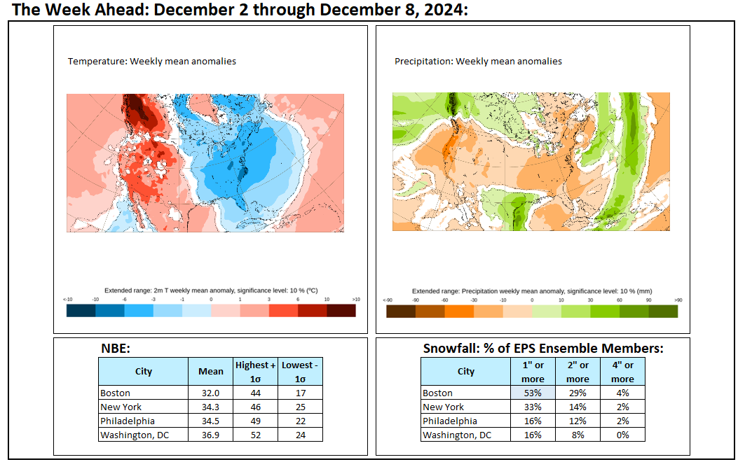
A cold air mass continues to cover the region. A few locations saw some flurries this afternoon into this evening. The most recent guidance is suggesting that even as the first 10 days of December will be unseasonably cold, the cold won't be as significant as on the earlier guidance. Nevertheless, on account of successive waves of cold, the first two weeks of December will likely feature mainly below normal temperatures. The long-range guidance remains in good agreement for a cold first half of December. Significant lake effect snow remains likely. The pattern will likely be a fairly quiet one. As a result, the Washington, DC to New York City area likely won't see any appreciable snowfall during the first two weeks of December. However, a clipper system could bring a period of light snow or flurries to parts of the region late Wednesday into Thursday. A snow squall is possible in parts of the area as the cold air rushes back into the region behind the clipper. The NAO fell to a preliminary -2.751 on September 24th (all-time September record: -2.371, September 12, 1971). That was the 9th lowest value on record. La Niña winters following September cases where the NAO fell to -1.900 or below featured a predominantly positive NAO. The most recent such winters were 2016-2017 and 2022-2023. The mean temperatures for those winters in New York City were 39.3° and 41.0° respectively. The 1991-2020 normal value is 36.2°. A warmer to much warmer than normal outcome is favored by the November run of the ECMWF for Winter 2024-2025. The ENSO Region 1+2 anomaly was +0.3°C and the Region 3.4 anomaly was -0.3°C for the week centered around November 27. For the past six weeks, the ENSO Region 1+2 anomaly has averaged +0.07°C and the ENSO Region 3.4 anomaly has averaged -0.23°C. Neutral ENSO conditions may still evolve into a La Niña event during the winter. Uncertainty as to whether a La Niña will actually develop continues to increase. Currently, 47% of dynamical models and 22% of the statistical models forecast the development of a La Niña. The SOI was +14.01 today. The preliminary Arctic Oscillation (AO) was -0.667 today.
-
Final Outcomes:
-
Winter 2024-25 has gotten off to a cold start. This morning the temperature fell to 27° in New York City's Central Park. That was the first sub-30° low since March 22nd and the coldest low temperature since February 17th when the mercury also dipped to 27°. The first 10 days of December will likely see a mean temperature below 34° in New York City. The last time that happened was in 2002, when the first 10 days of December had a mean temperature of 31.2°. December will likely wind up somewhat colder than normal overall. In fact, since 1980, all four cases with a December 1-10 mean temperature below 36.5° preceded a colder than normal December while 85% of the remaining cases saw a warmer than normal December. The sensitivity analysis applied to the latest guidance showed an implied 68% probability of a colder than normal December. On account of successive waves of cold, the first two weeks of December will likely feature mainly below normal temperatures. The long-range guidance remains in good agreement for a cold first half of December. Significant lake effect snow remains likely even as the current event will wind down. So far, the current event has seen 46.0" at Barnes Corners (4 SW), NY and Copenhagen (4 NW). In addition, daily snowfall at Erie came to 22.6" on November 29th, which broke the all-time daily mark of 21.8" that was set on December 16, 2017. At least through the first week of December, precipitation will likely be below to much below normal in the region. Nevertheless, a clipper system could bring a period of light snow or flurries to parts of the region late Tuesday night into Wednesday. The NAO fell to a preliminary -2.751 on September 24th (all-time September record: -2.371, September 12, 1971). That was the 9th lowest value on record. La Niña winters following September cases where the NAO fell to -1.900 or below featured a predominantly positive NAO. The most recent such winters were 2016-2017 and 2022-2023. The mean temperatures for those winters in New York City were 39.3° and 41.0° respectively. The 1991-2020 normal value is 36.2°. A warmer to much warmer than normal outcome is favored by the November run of the ECMWF for Winter 2024-2025. The ENSO Region 1+2 anomaly was +0.8°C and the Region 3.4 anomaly was -0.1°C for the week centered around November 20. For the past six weeks, the ENSO Region 1+2 anomaly has averaged 0.00°C and the ENSO Region 3.4 anomaly has averaged -0.23°C. Neutral ENSO conditions may still evolve into a La Niña event during the winter. Uncertainty as to whether a La Niña will actually develop continues to increase. The SOI was +6.80 today. The preliminary Arctic Oscillation (AO) was -1.478 today.
-
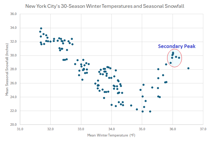
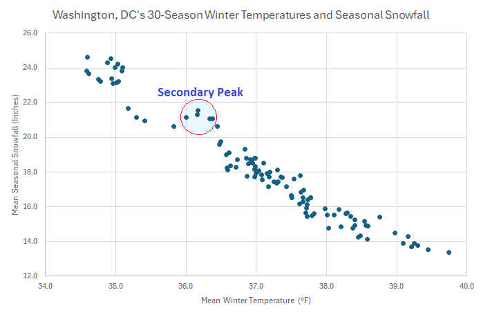
Back during winter 2022-2023, I posted some information concerning how a warming climate might affect seasonal snowfall in New York City. Based on the experience of cities south of New York City, by the mid-2030s, seasonal snowfall (30-season average) could reach or fall below 20" per season. It is still too soon to be sure whether the two most recent relatively snowless winters are part of the early stages of a transition to a less snowy future. Even in a less snowy future, periodic snowy winters remain likely. Looking further into the matter, it seems that some locations, including Philadelphia and Washington, DC have seen a temporary increase in seasonal snowfall as the mean winter temperature approached and then exceeded 36.0°. That outcome is probably the result of an increase in moisture exceeding the consequences of a warming climate where bigger snowstorms skew seasonal averages. A larger initial secondary increase in snowfall is likely farther north than Washington, DC or Philadelphia, as New York City (and also Boston) are closer to sources of sufficiently cold air. Eventually, the warmth more than offset the gains resulting from increased moisture. Below are the current charts for both New York City and Washington, DC:
-
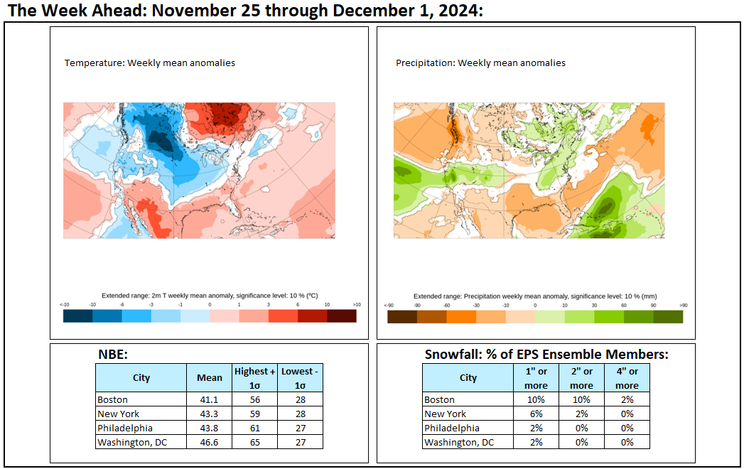
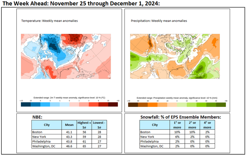
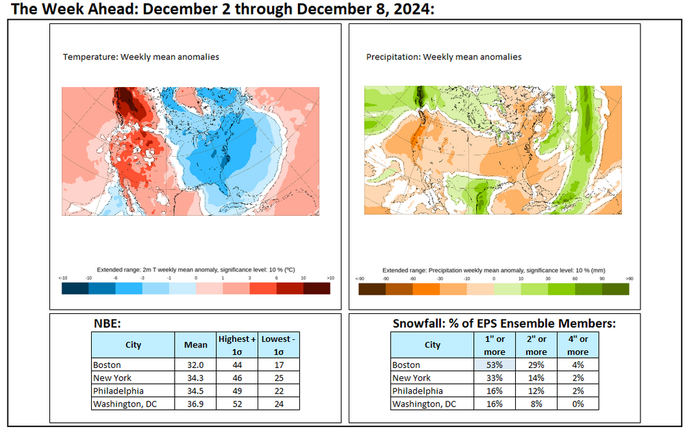
The week ahead looks cold and mainly dry. A clipper system could bring some light snow or flurries, especially from eastern Pennsylvania into New England late Tuesday night into Wednesday.
-
November summary:
-
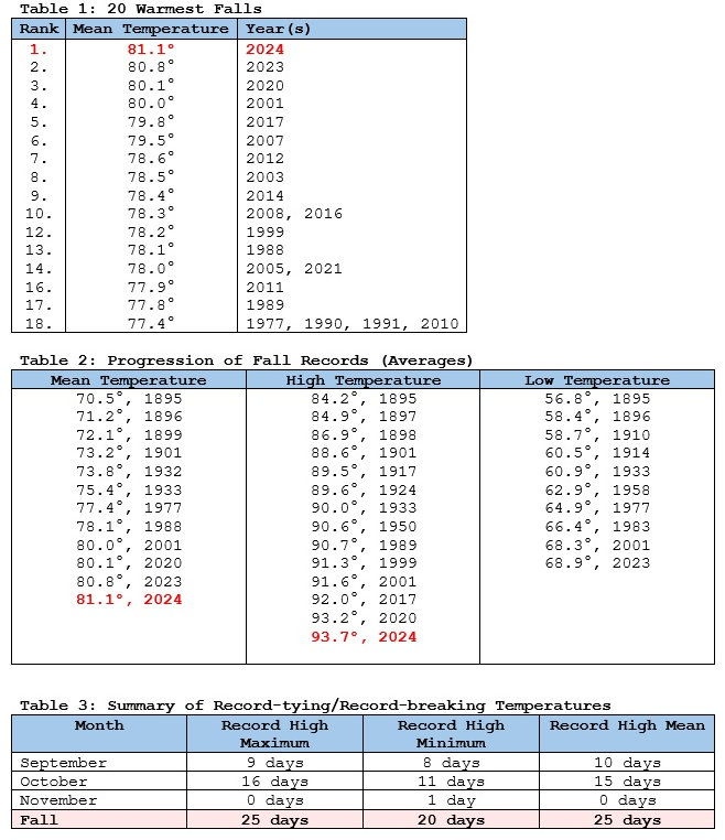
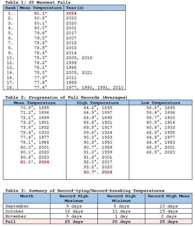
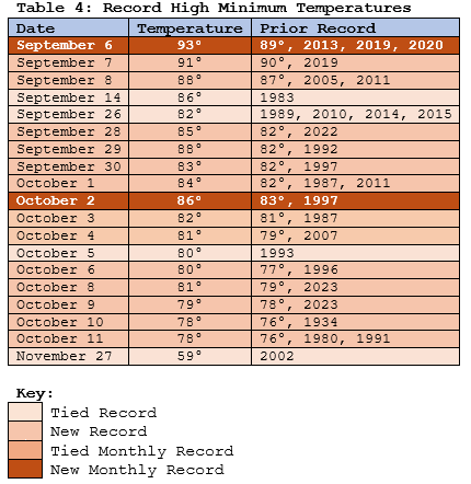
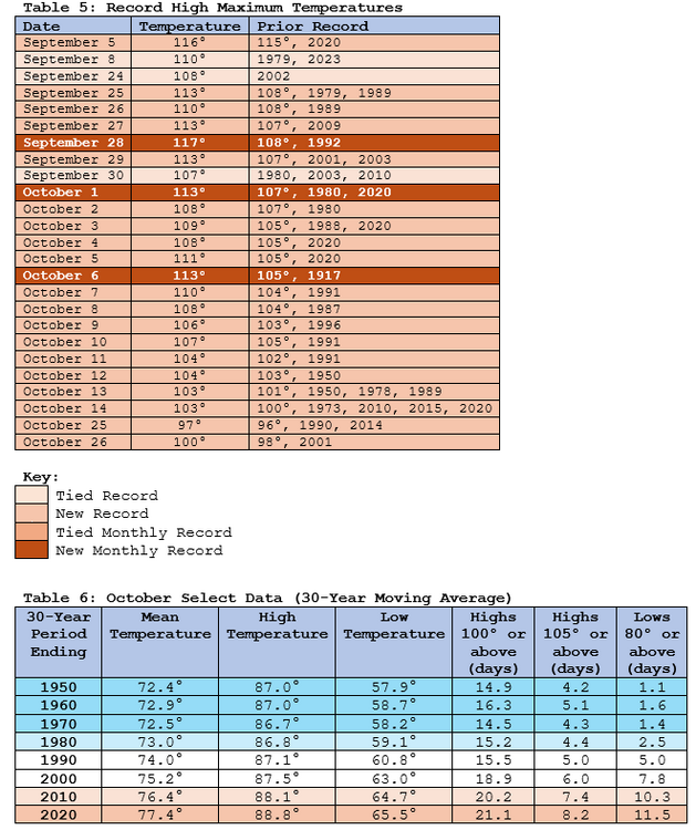
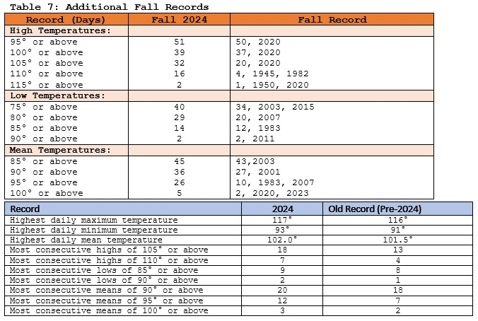
Phoenix Follows its Hottest Summer with its Warmest Fall on Record Phoenix experienced its warmest fall on record. An unprecedented autumn heatwave that was unlike anything in the Southwest’s climate record drove the outcome. Phoenix finished with a seasonal mean temperature of 81.1° (1st highest), seasonal average high temperature of 93.7° (1st highest), and seasonal average low temperature of 68.5° (2nd highest). Climate change has played a leading role. Since 1895, there were 14 fall cases with a seasonal mean high temperature of 90° or above. The first occurred in 1933. Since 2000, there were 9 such cases (64% of cases) even as the 2000-2024 period comprised 19% of Phoenix’s climate record. Since 2010, there were 6 such cases (43% of cases) even as the 2010-2024 period made up 12% of Phoenix’s climate record. Since 2020, there have been 4 such cases (29% of cases), even as the 2020-2024 period accounted for 4% of Phoenix’s climate record. On account of the long, warm fall, Phoenix’s year-to-date average temperature finished November at 80.1°. The previous record latest 80° or above year-to-date average temperature was November 12, 2020. The previous highest year-to-date temperature through November 30th was 79.3° in 2020. On account of the record hot summer and record warm Fall, Phoenix is virtually certain to experience its warmest year on record. Prior to the start of summer, 2024 was tied for the 21st warmest year on record, 2.2° below the mean for 2014, which was the warmest year on record through May 31st.
-
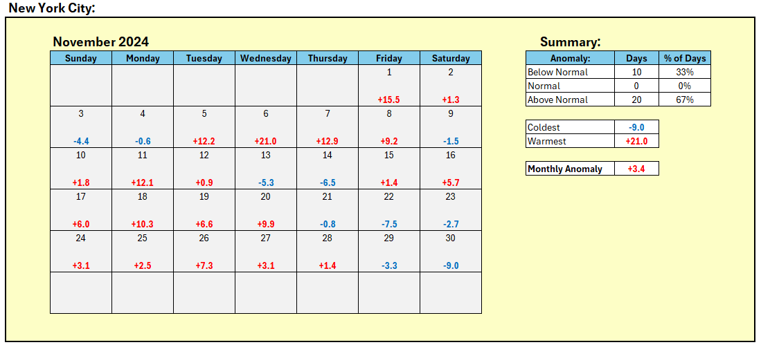
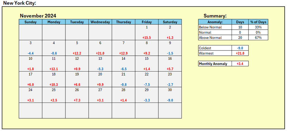
This morning, the temperature fell to 30° in New York City's Central Park. That was the Park's first freeze of the season. The average first freeze occurs on November 21st. That's 10 days later than the 1961-1990 average. Overall, November was warmer than normal. The average temperature was 51.4°, which was 3.4° above normal. Fall 2024 had a mean temperature of 60.4°, which was tied with 2017 for the 6th warmest fall on record. Winter 2024-25 will get off to a cold start. The first 10 days of December will likely see a mean temperature below 34° in New York City. The last time that happened was in 2002, when the first 10 days of December had a mean temperature of 31.2°. December will likely wind up somewhat colder than normal overall. In fact, since 1980, all four cases with a December 1-10 mean temperature below 36.5° preceded a colder than normal December while 85% of the remaining cases saw a warmer than normal December. The sensitivity analysis applied to the latest guidance showed an implied 65% probability of a colder than normal December. On account of successive waves of cold, the first two weeks of December will likely feature mainly below normal temperatures. The long-range guidance remains in good agreement for a cold first half of December. Significant lake effect snow is likely. At least through much of the first week of December, precipitation will likely be below to much below normal in the region. Nevertheless, a clipper system could bring a period of light snow or flurries to parts of the region late Tuesday night into Wednesday. The NAO fell to a preliminary -2.751 on September 24th (all-time September record: -2.371, September 12, 1971). That was the 9th lowest value on record. La Niña winters following September cases where the NAO fell to -1.900 or below featured a predominantly positive NAO. The most recent such winters were 2016-2017 and 2022-2023. The mean temperatures for those winters in New York City were 39.3° and 41.0° respectively. The 1991-2020 normal value is 36.2°. A warmer to much warmer than normal outcome is favored by the November run of the ECMWF for Winter 2024-2025. The ENSO Region 1+2 anomaly was +0.8°C and the Region 3.4 anomaly was -0.1°C for the week centered around November 20. For the past six weeks, the ENSO Region 1+2 anomaly has averaged 0.00°C and the ENSO Region 3.4 anomaly has averaged -0.23°C. Neutral ENSO conditions may still evolve into a La Niña event during the winter. Uncertainty as to whether a La Niña will actually develop continues to increase. The SOI was +6.80 today. The preliminary Arctic Oscillation (AO) was -1.624 today.
-
Major Lake Effect Snowstorm: Nov 29-Dec 4th
donsutherland1 replied to BuffaloWeather's topic in Upstate New York/Pennsylvania
871 NOUS41 KCLE 301639 PNSCLE OHZ003-006>014-017>023-027>033-036>038-047-089-PAZ001>003-010439- Public Information Statement Spotter Reports National Weather Service Cleveland OH 1139 AM EST Sat Nov 30 2024 The following are unofficial observations taken during the past 11 hours for the storm that has been affecting our region. Appreciation is extended to highway departments, cooperative observers, Skywarn spotters, and media for these reports. This summary also is available on our home page at weather.gov/cleveland ********************STORM TOTAL SNOWFALL******************** LOCATION TOTAL TIME/DATE COMMENTS SNOWFALL MEASURED (inches) OHIO ...Ashtabula County... 1 ESE Ashtabula 39.0 1126 AM 11/30 Trained Spotter 1 NNE Saybrook 37.1 430 AM 11/30 Trained Spotter Edgewood 33.2 915 AM 11/30 Trained Spotter 1 NNE Geneva 32.0 640 AM 11/30 Trained Spotter 2 ESE Monroe Center 26.0 800 AM 11/30 Trained Spotter 3 E South Madison 20.4 730 AM 11/30 Trained Spotter 3 ENE Trumbull 13.5 934 AM 11/30 Trained Spotter 4 SE Harpersfield 12.2 726 AM 11/30 Trained Spotter ...Cuyahoga County... Pepper Pike T 800 AM 11/30 Trained Spotter 1 ENE Lyndhurst T 930 AM 11/30 Trained Spotter ...Geauga County... 2 ESE South Thompson 10.0 858 AM 11/30 Trained Spotter 2 ENE Russell Center T 700 AM 11/30 Trained Spotter ...Lake County... North Madison 23.5 700 AM 11/30 Trained Spotter 3 W South Madison 21.6 855 AM 11/30 Trained Spotter 2 WSW North Madison 20.0 820 AM 11/30 Trained Spotter 2 ESE Perry 18.0 730 AM 11/30 Trained Spotter 2 WNW Concord 12.2 845 AM 11/30 Trained Spotter Mentor-on-the-Lake 6.7 830 AM 11/30 Trained Spotter 2 SSW Mentor-On-the- 6.0 900 AM 11/30 Trained Spotter 2 S Waite Hill 5.5 800 AM 11/30 Trained Spotter ...Lucas County... 3 N Holland T 730 AM 11/30 Trained Spotter 1 ESE Neapolis T 800 AM 11/30 Trained Spotter ...Mahoning County... 2 ESE Austintown 0.9 654 AM 11/30 Trained Spotter Canfield 0.7 900 AM 11/30 Trained Spotter ...Portage County... 2 W Ravenna T 705 AM 11/30 Trained Spotter ...Stark County... 2 ENE Canton 0.5 520 AM 11/30 Trained Spotter ...Summit County... 1 W Barberton 2.5 820 AM 11/30 Trained Spotter PENNSYLVANIA ...Crawford County... 3 NW Venango 12.3 705 AM 11/30 Trained Spotter 3 NE Cochranton 0.8 630 AM 11/30 Trained Spotter ...Erie County... 2 ESE North East 42.3 700 AM 11/30 Trained Spotter Northwest Harborcree 38.2 825 AM 11/30 Trained Spotter 4 S Wesleyville 38.0 800 AM 11/30 Trained Spotter 4 W Colt Station 38.0 700 AM 11/30 Trained Spotter 1 NW Harborcreek 33.3 630 AM 11/30 Trained Spotter 2 SW Wesleyville 31.4 801 AM 11/30 Trained Spotter 2 ESE Erie 31.0 720 AM 11/30 Trained Spotter 2 W Avonia 24.0 730 AM 11/30 Trained Spotter 2 NW Edinboro 20.0 600 AM 11/30 Trained Spotter 2 E Edinboro 16.9 830 AM 11/30 Trained Spotter 1 WNW Union City 9.1 730 AM 11/30 Trained Spotter **********************12 HOUR SNOWFALL********************** LOCATION 12 HOUR TIME/DATE COMMENTS SNOWFALL MEASURED (inches) OHIO ...Ashtabula County... 1 NNE Saybrook 23.5 807 AM 11/30 Trained Spotter 1 NNE Geneva 19.5 640 AM 11/30 Trained Spotter Edgewood 13.7 915 AM 11/30 Trained Spotter 2 ESE Monroe Center 13.3 800 AM 11/30 Trained Spotter 2 S Ashtabula 11.0 803 AM 11/30 Trained Spotter 3 E South Madison 6.2 730 AM 11/30 Trained Spotter 1 ENE Jefferson 6.2 500 AM 11/30 Trained Spotter 4 SE Harpersfield 3.8 726 AM 11/30 Trained Spotter ...Cuyahoga County... 2 W Russell Center T 730 AM 11/30 Trained Spotter 1 NNE Broadview Heig T 800 AM 11/30 Trained Spotter 2 S Brooklyn T 830 AM 11/30 Trained Spotter Pepper Pike T 800 AM 11/30 Trained Spotter 1 ENE Lyndhurst T 930 AM 11/30 Trained Spotter ...Geauga County... 2 ESE South Thompson 0.5 858 AM 11/30 Trained Spotter 3 ESE Newbury T 700 AM 11/30 Trained Spotter 3 SW Chardon T 800 AM 11/30 Trained Spotter 2 ENE Russell Center T 700 AM 11/30 Trained Spotter ...Lake County... North Madison 15.0 700 AM 11/30 Trained Spotter 2 WSW North Madison 11.5 820 AM 11/30 Trained Spotter 3 W South Madison 9.0 855 AM 11/30 Trained Spotter 2 ESE Perry 8.6 730 AM 11/30 Trained Spotter 2 WNW Concord 3.0 845 AM 11/30 Trained Spotter Mentor-on-the-Lake 2.7 830 AM 11/30 Trained Spotter 2 SSW Mentor-On-the- 2.0 900 AM 11/30 Trained Spotter 1 SSE Mentor 2.0 913 AM 11/30 Trained Spotter Willoughby 0.1 700 AM 11/30 Trained Spotter 1 W Eastlake T 800 AM 11/30 Trained Spotter 2 S Waite Hill T 800 AM 11/30 Trained Spotter ...Lorain County... 2 S Vermilion T 730 AM 11/30 Trained Spotter ...Lucas County... 3 N Holland T 730 AM 11/30 Trained Spotter 1 ESE Neapolis T 800 AM 11/30 Trained Spotter ...Medina County... 2 SSE Sharon Center 0.1 700 AM 11/30 Trained Spotter 2 E Homerville T 700 AM 11/30 Trained Spotter ...Portage County... 2 ENE Reminderville T 545 AM 11/30 Trained Spotter 2 W Ravenna T 705 AM 11/30 Trained Spotter ...Richland County... 1 ENE Lexington T 700 AM 11/30 Trained Spotter ...Sandusky County... 1 N Gibsonburg T 750 AM 11/30 Trained Spotter 2 ESE Woodville T 900 AM 11/30 Trained Spotter ...Stark County... 1 N Canton T 915 AM 11/30 Trained Spotter ...Summit County... 1 W Barberton 0.3 820 AM 11/30 Trained Spotter ...Trumbull County... 1 NE Cortland T 700 AM 11/30 Trained Spotter PENNSYLVANIA ...Crawford County... 3 NW Venango 5.0 705 AM 11/30 Trained Spotter 5 SW Canadohta Lake 1.7 925 AM 11/30 Trained Spotter 3 NE Cochranton 0.1 630 AM 11/30 Trained Spotter 3 SE Meadville T 828 AM 11/30 Trained Spotter ...Erie County... 1 WNW North East 14.0 944 AM 11/30 Trained Spotter Girard 12.0 600 AM 11/30 Trained Spotter Northwest Harborcree 11.5 825 AM 11/30 Trained Spotter 2 ESE Erie 11.0 720 AM 11/30 Trained Spotter 4 W Colt Station 11.0 700 AM 11/30 Trained Spotter 4 SE Harborcreek 11.0 600 AM 11/30 Trained Spotter 4 S Wesleyville 11.0 800 AM 11/30 Trained Spotter 2 NW Edinboro 11.0 600 AM 11/30 Trained Spotter 2 ESE North East 10.2 700 AM 11/30 Trained Spotter 1 NW Harborcreek 8.5 630 AM 11/30 Trained Spotter 2 E Edinboro 7.9 830 AM 11/30 Trained Spotter 2 SW Wesleyville 5.9 801 AM 11/30 Trained Spotter 2 W Avonia 3.0 730 AM 11/30 Trained Spotter 1 WNW Union City 2.8 730 AM 11/30 Trained Spotter **********************24 HOUR SNOWFALL********************** LOCATION 24 HOUR TIME/DATE COMMENTS SNOWFALL MEASURED (inches) OHIO ...Ashland County... 4 SW Ashland 0.1 715 AM 11/30 CoCoRaHS ...Ashtabula County... 3 S Kingsville 29.5 850 AM 11/30 Trained Spotter 1 ESE Ashtabula 27.0 1126 AM 11/30 Trained Spotter 2 S Harpersfield 6.0 920 AM 11/30 Trained Spotter 3 ENE Trumbull 5.0 934 AM 11/30 Trained Spotter ...Erie County... 1 SW Birmingham T 800 AM 11/30 Trained Spotter ...Geauga County... 4 S Madison 9.0 700 AM 11/30 CoCoRaHS 3 WSW Auburn Corners 0.5 800 AM 11/30 CoCoRaHS 3 ESE Newbury T 700 AM 11/30 Trained Spotter ...Lake County... 3 N Willoughby 4.2 700 AM 11/30 CoCoRaHS ...Lorain County... 2 NE North Ridgevill T 800 AM 11/30 Trained Spotter ...Mahoning County... 2 ESE Austintown 0.9 654 AM 11/30 Trained Spotter 1 N Canfield 0.5 845 AM 11/30 CoCoRaHS Canfield 0.5 900 AM 11/30 Trained Spotter 2 W North Lima 0.5 700 AM 11/30 CoCoRaHS ...Medina County... 5 WNW Wadsworth 0.2 500 AM 11/30 CoCoRaHS ...Portage County... 1 E Ravenna 0.3 700 AM 11/30 CoCoRaHS 4 SE Kent 0.2 700 AM 11/30 CoCoRaHS ...Stark County... 2 ENE Canton 0.5 520 AM 11/30 Trained Spotter ...Summit County... 1 SW Munroe Falls 0.2 700 AM 11/30 Co-Op Observer ...Wayne County... 2 ESE Doylestown 4.0 915 AM 11/30 CoCoRaHS ...Wood County... 2 WSW Perrysburg 0.1 900 AM 11/30 CoCoRaHS PENNSYLVANIA ...Crawford County... 3 WNW Springboro 12.6 700 AM 11/30 Co-Op Observer ...Erie County... 2 WSW Erie 29.0 531 AM 11/30 CoCoRaHS 1 WNW North East 27.7 800 AM 11/30 CoCoRaHS 1 NNW Corry 3.0 730 AM 11/30 CoCoRaHS ***********************SNOW ON GROUND*********************** LOCATION SNOW TIME/DATE COMMENTS ON GROUND MEASURED (inches) OHIO ...Ashland County... 4 SW Ashland 0.5 715 AM 11/30 CoCoRaHS ...Ashtabula County... 1 ESE Ashtabula 39.0 1126 AM 11/30 Trained Spotter Edgewood 33.0 915 AM 11/30 Trained Spotter 1 NNE Saybrook 30.0 807 AM 11/30 Trained Spotter 2 ESE Monroe Center 23.0 800 AM 11/30 Trained Spotter 2 S Ashtabula 22.0 803 AM 11/30 Trained Spotter 3 E South Madison 15.0 730 AM 11/30 Trained Spotter 2 S Harpersfield 14.0 920 AM 11/30 Trained Spotter 4 SE Harpersfield 12.0 726 AM 11/30 Trained Spotter 1 ENE Jefferson 11.0 500 AM 11/30 Trained Spotter 3 ENE Trumbull 10.0 934 AM 11/30 Trained Spotter ...Erie County... 1 SW Birmingham T 800 AM 11/30 Trained Spotter ...Geauga County... 4 S Madison 16.0 700 AM 11/30 CoCoRaHS 2 ESE South Thompson 9.0 858 AM 11/30 Trained Spotter ...Lake County... North Madison 22.0 700 AM 11/30 Trained Spotter 2 WSW North Madison 19.0 820 AM 11/30 Trained Spotter 3 W South Madison 18.0 855 AM 11/30 Trained Spotter 2 WNW Concord 11.0 845 AM 11/30 Trained Spotter Mentor-on-the-Lake 7.0 830 AM 11/30 Trained Spotter 2 SSW Mentor-On-the- 6.0 900 AM 11/30 Trained Spotter 1 SSE Mentor 6.0 913 AM 11/30 Trained Spotter 2 S Waite Hill 5.0 800 AM 11/30 Trained Spotter ...Lorain County... 2 NE North Ridgevill T 800 AM 11/30 Trained Spotter ...Lucas County... 1 ESE Neapolis T 800 AM 11/30 Trained Spotter ...Mahoning County... 1 N Canfield 0.5 845 AM 11/30 CoCoRaHS 2 W North Lima 0.5 700 AM 11/30 CoCoRaHS ...Medina County... 2 SSE Sharon Center 1.0 700 AM 11/30 Trained Spotter ...Portage County... 1 E Ravenna 0.2 700 AM 11/30 CoCoRaHS 4 SE Kent 0.2 700 AM 11/30 CoCoRaHS ...Sandusky County... 2 ESE Woodville T 900 AM 11/30 Trained Spotter ...Stark County... 2 ENE Canton T 520 AM 11/30 Trained Spotter ...Summit County... 1 W Barberton 1.0 820 AM 11/30 Trained Spotter PENNSYLVANIA ...Crawford County... 3 WNW Springboro 12.0 700 AM 11/30 Co-Op Observer 5 SW Canadohta Lake 3.0 925 AM 11/30 Trained Spotter 3 NE Cochranton T 630 AM 11/30 Trained Spotter 3 SE Meadville T 828 AM 11/30 Trained Spotter ...Erie County... Girard 42.0 600 AM 11/30 Trained Spotter 2 ESE North East 41.0 700 AM 11/30 Trained Spotter 4 SE Harborcreek 30.0 600 AM 11/30 Trained Spotter 1 WNW North East 29.0 944 AM 11/30 Trained Spotter 4 W Colt Station 29.0 700 AM 11/30 Trained Spotter 4 S Wesleyville 27.0 800 AM 11/30 Trained Spotter 2 W Avonia 24.0 730 AM 11/30 Trained Spotter 2 NW Edinboro 20.0 600 AM 11/30 Trained Spotter 2 E Edinboro 12.0 830 AM 11/30 Trained Spotter 1 NNW Corry 7.0 730 AM 11/30 CoCoRaHS 1 WNW Union City 6.0 730 AM 11/30 Trained Spotter && -
Thanks. I thought I had loaded the CLE local storm reports, but didn’t.
-
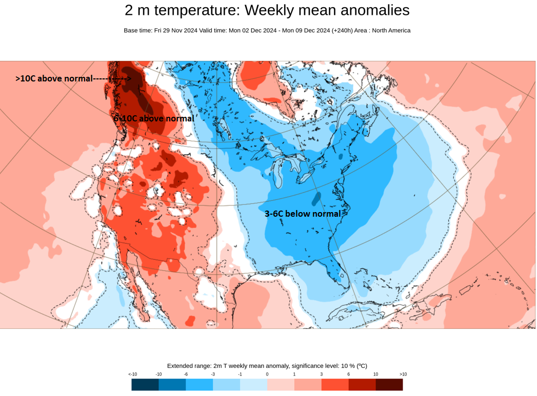
So far, the ideas expressed last Sunday remain in good shape. 1. The first half of December continues to look cold with a weekly anomaly of 6°-10° below normal likely during that period. In fact, New York City could have its coldest December 1-10 period since 2002. 2. A significant lake effect snow event is underway. Several locations have seen excessive lake effect snow so far. Cassadaga, NY (31.6") and Mayville, NY (30.0") have the highest amounts so far. Buffalo has received a trace of snow, but as the lake effect snow bands move northward today, accumulating snow is likely there. Chicago (2.9"), Detroit (1.7"), and Toronto (0.2 cm) have all seen measurable snow. No measurable snow has fallen in Boston, New York City, or Philadelphia. 3. The potential for a colder than normal December has increased in parts of the eastern third of the U.S. Since 1980, all four cases where New York City had a mean temperature of 36.5° or below, wound up having a colder than normal December. The latest guidance shows New York City with a December 1-10 mean temperature near 32.5°. The outcome farther west in such cties as Chicago, Detroit, and Indianapolis remains less certain and will depend on the timing of the pattern change. The farther east one is, the more likely that the month will come out with a colder anomaly. 4. The CFSv2 is pushing a warmup around mid-month. The November 29 12z ECMWF weeklies are holding it off for an additional week. As noted previously, the guidance has tended to rush the timing of pattern changes. Four thoughts going forward: 1. The EPO is forecast to head toward neutral levels toward mid-month. The AO and PNA are also forecast to head toward neutral levels. Therefore, a pattern change seems likely, but probably with a lag that could favor the timing shown on the ECMWF weeklies. 2. Even as the pattern in the East is likely to be dry for much of the first week of December, a clipper system could bring some light snow or flurries to the northern Mid-Atlantic/southern New England areas late Tuesday night and Wednesday. Boston might have a chance to pick up an inch of snow. Philadelphia and possibly New York City might only see some flurries. 3. Following the clipper, the coldest air so far this season will move into the eastern third of the U.S. 4. Out West, British Columbia could see a period of near record and record warmth develop for Tuesday through Thursday (December 3-5). Overall, the exceptional warmth in BC and the cold in the East showed up quite well on the November 29 12z ECMWF Weeklies.
-
DCA _ NYC _ BOS __ ORD _ ATL _ IAH __ DEN _ PHX _ SEA 0.0 -0.5 -0.3 1.2 0.2 1.7 3.6 3.6 4.4 DCA _ NYC _ BOS __ ORD _ DTW _ BuF __ DEN _ SEA _ BTV 8.0 16.5 35.0 40.0 45.0 95.0 55.0 8.0 75.0
-
Enjoy them. Yes, growing season will be ending now. I hope you had a great Thanksgiving Day.
-
A colder regime is now settling into place and will likely persist through at least mid-December. There will be some sprinkles or flurries this evening. Afterward, the skies wil clear. New York City's Central Park will very likely experience its first freeze of the season tomorrow morning. The average first freeze occurs on November 21st. That's 10 days later than the 1961-1990 average. On account of successive waves of cold, the first two weeks of December will likely feature mainly below normal temperatures. The long-range guidance remains in good agreement for a cold first half of December. Significant lake effect snow is likely. At least through much of the first week of December, precipitation will likely be below to much below normal in the region. The NAO fell to a preliminary -2.751 on September 24th (all-time September record: -2.371, September 12, 1971). That was the 9th lowest value on record. La Niña winters following September cases where the NAO fell to -1.900 or below featured a predominantly positive NAO. The most recent such winters were 2016-2017 and 2022-2023. The mean temperatures for those winters in New York City were 39.3° and 41.0° respectively. The 1991-2020 normal value is 36.2°. A warmer to much warmer than normal outcome is favored by the November run of the ECMWF for Winter 2024-2025. The ENSO Region 1+2 anomaly was +0.8°C and the Region 3.4 anomaly was -0.1°C for the week centered around November 20. For the past six weeks, the ENSO Region 1+2 anomaly has averaged 0.00°C and the ENSO Region 3.4 anomaly has averaged -0.23°C. Neutral ENSO conditions may still evolve into a La Niña event during the winter. Uncertainty as to whether a La Niña will actually develop continues to increase. The SOI was +6.49 today. The preliminary Arctic Oscillation (AO) was -1.544 today. Based on sensitivity analysis applied to the latest guidance, there is an implied near 100% probability that New York City will have a warmer than normal November (1991-2020 normal). November will likely finish with a mean temperature near 51.4° (3.4° above normal). November 2024 will be the third November since 2020 with a monthly mean temperature of 50° or above. In addition, Fall 2024 will likely finish with a seasonal mean temperature of 60.4°. That would tie Fall 2017 for the 6th warmest Fall on record.
-
I run the sensitivity analysis daily. The AO and SOI values are usually available each day.
-
The storm responsible for today's rain is now moving away from the region. In its wake, noticeably colder air will begin to move into the region. Below normal temperatures are likely for the remainder of November. On account of successive waves of cold, the first two weeks of December will likely feature mainly below normal temperatures. The long-range guidance remains in good agreement for a cold first half of December. Significant lake effect snow is likely. At least through much of the first week of December, precipitation will likely be below to much below normal in the region. The NAO fell to a preliminary -2.751 on September 24th (all-time September record: -2.371, September 12, 1971). That was the 9th lowest value on record. La Niña winters following September cases where the NAO fell to -1.900 or below featured a predominantly positive NAO. The most recent such winters were 2016-2017 and 2022-2023. The mean temperatures for those winters in New York City were 39.3° and 41.0° respectively. The 1991-2020 normal value is 36.2°. A warmer to much warmer than normal outcome is favored by the November run of the ECMWF for Winter 2024-2025. The ENSO Region 1+2 anomaly was +0.8°C and the Region 3.4 anomaly was -0.1°C for the week centered around November 20. For the past six weeks, the ENSO Region 1+2 anomaly has averaged 0.00°C and the ENSO Region 3.4 anomaly has averaged -0.23°C. Neutral ENSO conditions may still evolve into a La Niña event during the winter. Uncertainty as to whether a La Niña will actually develop continues to increase. The SOI was +19.91 today. The preliminary Arctic Oscillation (AO) was -1.196 today. Based on sensitivity analysis applied to the latest guidance, there is an implied near 100% probability that New York City will have a warmer than normal November (1991-2020 normal). November will likely finish with a mean temperature near 51.4° (3.4° above normal). November 2024 will be the third November since 2020 with a monthly mean temperature of 50° or above.
-
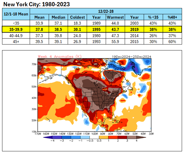
December 1-10 will very likely have a mean temperature below 40° (likely in the 37.5°-38.5° range based on the guidance). The Week 4 CFSv2 shows much above normal temperatures for the week that ends with Hanukkah and Christmas. Here's how NYC has fared since 1980 for following various mean temperatures for the December 1-10 period: Considering that 76% of cases following the December 1-10 value have averaged either below 35° or 40° or above for the December 25 +/-3 days period, the odds are probably tilted toward the latter given the CFSv2 forecast and EPS weeklies. The first half of December and possibly first three weeks could have a cold anomaly before the pattern breaks.
-
A cooler pattern is now in its early stages of developing. Rain will arrive late tonight. The rain will continue into tomorrow night. Some of the distant northern and western suburbs could see some snow mix in. A general 0.50"-1.00" rainfall is likely. Colder air will begin to move into the region following the Thanksgiving Day storm. On account of successive waves of cold, the first two weeks of December will likely feature mainly below normal temperatures. The long-range guidance remains in good agreement for a cold first half of December. Significant lake effect snow is likely. The NAO fell to a preliminary -2.751 on September 24th (all-time September record: -2.371, September 12, 1971). That was the 9th lowest value on record. La Niña winters following September cases where the NAO fell to -1.900 or below featured a predominantly positive NAO. The most recent such winters were 2016-2017 and 2022-2023. The mean temperatures for those winters in New York City were 39.3° and 41.0° respectively. The 1991-2020 normal value is 36.2°. A warmer to much warmer than normal outcome is favored by the November run of the ECMWF for Winter 2024-2025. The ENSO Region 1+2 anomaly was +0.8°C and the Region 3.4 anomaly was -0.1°C for the week centered around November 20. For the past six weeks, the ENSO Region 1+2 anomaly has averaged 0.00°C and the ENSO Region 3.4 anomaly has averaged -0.23°C. Neutral ENSO conditions may still evolve into a La Niña event during the winter. Uncertainty as to whether a La Niña will actually develop continues to increase. The SOI was +21.06 today. The preliminary Arctic Oscillation (AO) was +0.187 today. Based on sensitivity analysis applied to the latest guidance, there is an implied near 100% probability that New York City will have a warmer than normal November (1991-2020 normal). November will likely finish with a mean temperature near 51.4° (3.4° above normal). November 2024 will be the third November since 2020 with a monthly mean temperature of 50° or above.
-
In theory, yes. But a lot would have to happen for such a pattern to actually develop.
-
A cooler pattern is now imminent. It will turn cooler and increasingly cloudy tomorrow. Rain will arrive late tomorrow night or Thursday morning. The rain will continue into Thursday night. Distant northern and western suburbs could see some snow mix in. Colder air will begin to move into the region following the Thanksgiving Day storm. On account of successive waves of cold, the first two weeks of December will likely feature mainly below normal temperatures. The long-range guidance is in good agreement for a cold first half of December. Significant lake effect snow is possible. The NAO fell to a preliminary -2.751 on September 24th (all-time September record: -2.371, September 12, 1971). That was the 9th lowest value on record. La Niña winters following September cases where the NAO fell to -1.900 or below featured a predominantly positive NAO. The most recent such winters were 2016-2017 and 2022-2023. The mean temperatures for those winters in New York City were 39.3° and 41.0° respectively. The 1991-2020 normal value is 36.2°. A warmer to much warmer than normal outcome is favored by the November run of the ECMWF for Winter 2024-2025. The ENSO Region 1+2 anomaly was +0.8°C and the Region 3.4 anomaly was -0.1°C for the week centered around November 20. For the past six weeks, the ENSO Region 1+2 anomaly has averaged 0.00°C and the ENSO Region 3.4 anomaly has averaged -0.23°C. Neutral ENSO conditions may still evolve into a La Niña event during the winter. Uncertainty as to whether a La Niña will actually develop continues to increase. The SOI was +24.37 today. The preliminary Arctic Oscillation (AO) was +1.555 today. Based on sensitivity analysis applied to the latest guidance, there is an implied near 100% probability that New York City will have a warmer than normal November (1991-2020 normal). November will likely finish with a mean temperature near 51.2° (3.2° above normal).
-
It was a cold winter. The highlight was late December into early January, which featured extreme cold. NYC saw the temperature fall to -1° on December 25th.
-
Tomorrow will be the warmest day of the week and likely for some time to come. Temperatures will top out in the middle and perhaps upper 50s, even as showers and a period of rain are likely. A storm will bring additional rain on Thursday into Thursday night. Colder air will begin to move into the region following the Thanksgiving Day storm. On account of successive waves of cold, the first two weeks of December will likely feature mainly below normal temperatures. The long-range guidance is in good agreement for a cold first half of December. Significant lake effect snow is possible. The NAO fell to a preliminary -2.751 on September 24th (all-time September record: -2.371, September 12, 1971). That was the 9th lowest value on record. La Niña winters following September cases where the NAO fell to -1.900 or below featured a predominantly positive NAO. The most recent such winters were 2016-2017 and 2022-2023. The mean temperatures for those winters in New York City were 39.3° and 41.0° respectively. The 1991-2020 normal value is 36.2°. A warmer to much warmer than normal outcome is favored by the November run of the ECMWF for Winter 2024-2025. The ENSO Region 1+2 anomaly was +0.8°C and the Region 3.4 anomaly was -0.1°C for the week centered around November 20. For the past six weeks, the ENSO Region 1+2 anomaly has averaged 0.00°C and the ENSO Region 3.4 anomaly has averaged -0.23°C. Neutral ENSO conditions may still evolve into a La Niña event during the winter. Uncertainty as to whether a La Niña will actually develop continues to increase. The SOI was +17.62 today. The preliminary Arctic Oscillation (AO) was +1.120 today. Based on sensitivity analysis applied to the latest guidance, there is an implied near 100% probability that New York City will have a warmer than normal November (1991-2020 normal). November will likely finish with a mean temperature near 51.0° (3.0° above normal).
-
I suspect that the strengthening PV and lagged response to the development of an AO+/NAO+ will increase the risk for warming late in December. It will take some time to scour out the cold that will dominate during the first half of the month, especially when the PNA is positive.
-
I agree with his assessment. The MJO is currently in Phase 3 at a high amplitude. As it moves into and through the Maritime Continent, one would generally expect warmth in the East. The MJO's impact can be offset by other variables.