donsutherland1
-
Posts
24,195 -
Joined
Content Type
Profiles
Blogs
Forums
American Weather
Media Demo
Store
Gallery
Everything posted by donsutherland1
-
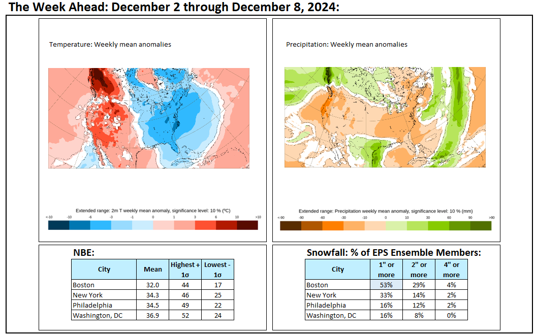
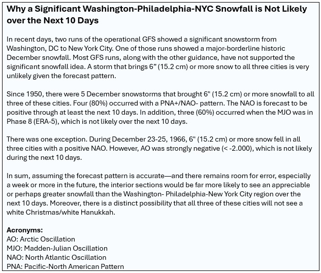
In the past few days, two runs of the operational GFS showed a significant snowfall for the Washington, DC-New York City area. Maps were posted on Social Media. However, the forecast pattern makes such large-scale significant snowfall unlikely.
-
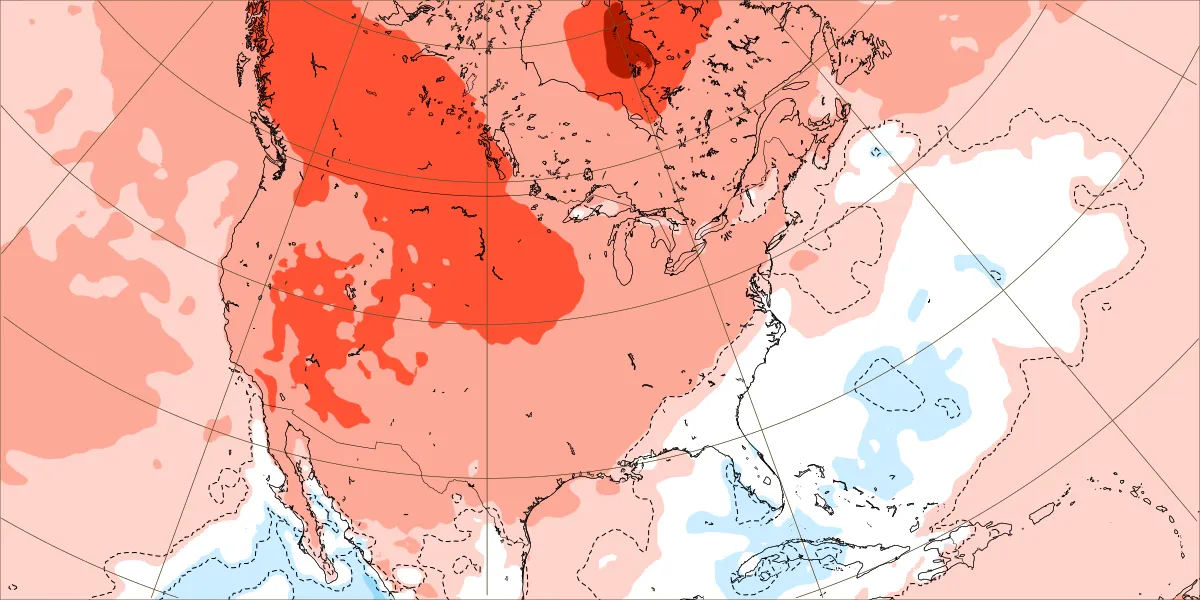
A much colder air mass now covers the region. The cold will last through the weekend before milder air returns early next week. It could then turn unseasonably mild for a time. Additional rain is possible early next week. Following the rain, it will again turn somewhat colder before a much sharper shot of cold arrives for during or after the next weekend. Beyond that, the pattern will likely remain changeable through much of the rest of the month on account of a fast jet stream. The overall anomaly for the final week of the month is unusually uncertain with most of the ensemble guidance and the weekly guidance in disagreement. However, the probability of a mild end to the month and mild start to January has increased. The NAO fell to a preliminary -2.751 on September 24th (all-time September record: -2.371, September 12, 1971). That was the 9th lowest value on record. La Niña winters following September cases where the NAO fell to -1.900 or below featured a predominantly positive NAO. The most recent such winters were 2016-2017 and 2022-2023. The mean temperatures for those winters in New York City were 39.3° and 41.0° respectively. The 1991-2020 normal value is 36.2°. A warmer to much warmer than normal outcome is favored by the November run of the ECMWF for Winter 2024-2025. The ENSO Region 1+2 anomaly was +0.1°C and the Region 3.4 anomaly was -0.3°C for the week centered around December 4. For the past six weeks, the ENSO Region 1+2 anomaly has averaged +0.12°C and the ENSO Region 3.4 anomaly has averaged -0.20°C. Neutral ENSO conditions may still evolve into a La Niña event during the winter. Uncertainty as to whether a La Niña will actually develop continues to increase. Currently, 47% of dynamical models and 22% of the statistical models forecast the development of a La Niña. The SOI was +5.66 today. The preliminary Arctic Oscillation (AO) was -1.050 today. Based on sensitivity analysis applied to the latest guidance, there is an implied 73% probability that New York City will have a colder than normal December (1991-2020 normal). December will likely finish with a mean temperature near 37.5° (1.6° below normal).
-
Unfortunately, unless things change, NYC seems on course for less than 3” snow this month. The fast Pacific jet and NAO+ suggest a hostile environment for big storms like what was shown on yesterday’s 12z GFS. Smaller snowfalls might still occur if precipitation coincides with colder periods.
-
It’s beginning to look like January could open on a mild note.
-
A much colder air mass has returned to the region. The cold will last through Saturday before milder air starts to return on Sunday. It could turn unseasonably mild early next week. Additional rain is possible early next week. Following the rain, it will again turn somewhat colder. Beyond that, the pattern will likely remain changeable through much of the rest of the month on account of a fast jet stream. The overall anomaly for the final week of the month is unusually uncertain with most of the ensemble guidance and the weekly guidance in disagreement. The NAO fell to a preliminary -2.751 on September 24th (all-time September record: -2.371, September 12, 1971). That was the 9th lowest value on record. La Niña winters following September cases where the NAO fell to -1.900 or below featured a predominantly positive NAO. The most recent such winters were 2016-2017 and 2022-2023. The mean temperatures for those winters in New York City were 39.3° and 41.0° respectively. The 1991-2020 normal value is 36.2°. A warmer to much warmer than normal outcome is favored by the November run of the ECMWF for Winter 2024-2025. The ENSO Region 1+2 anomaly was +0.1°C and the Region 3.4 anomaly was -0.3°C for the week centered around December 4. For the past six weeks, the ENSO Region 1+2 anomaly has averaged +0.12°C and the ENSO Region 3.4 anomaly has averaged -0.20°C. Neutral ENSO conditions may still evolve into a La Niña event during the winter. Uncertainty as to whether a La Niña will actually develop continues to increase. Currently, 47% of dynamical models and 22% of the statistical models forecast the development of a La Niña. The SOI was -0.99 today. The preliminary Arctic Oscillation (AO) was -1.588 today. Based on sensitivity analysis applied to the latest guidance, there is an implied 66% probability that New York City will have a colder than normal December (1991-2020 normal). December will likely finish with a mean temperature near 37.8° (1.3° below normal).
-
This is exactly the type of work BAMWX should be doing.
-
In the wake of today's storm, it will turn briefly noticeably colder tomorrow through Saturday before milder air starts to return on Sunday. It could be unseasonably mild early next week. Early indications are that Christmas and Hanukkah 2024 will feature warmer than normal conditions in the northern Mid-Atlantic and southern New England areas. The NAO fell to a preliminary -2.751 on September 24th (all-time September record: -2.371, September 12, 1971). That was the 9th lowest value on record. La Niña winters following September cases where the NAO fell to -1.900 or below featured a predominantly positive NAO. The most recent such winters were 2016-2017 and 2022-2023. The mean temperatures for those winters in New York City were 39.3° and 41.0° respectively. The 1991-2020 normal value is 36.2°. A warmer to much warmer than normal outcome is favored by the November run of the ECMWF for Winter 2024-2025. The ENSO Region 1+2 anomaly was +0.1°C and the Region 3.4 anomaly was -0.3°C for the week centered around December 4. For the past six weeks, the ENSO Region 1+2 anomaly has averaged +0.12°C and the ENSO Region 3.4 anomaly has averaged -0.20°C. Neutral ENSO conditions may still evolve into a La Niña event during the winter. Uncertainty as to whether a La Niña will actually develop continues to increase. Currently, 47% of dynamical models and 22% of the statistical models forecast the development of a La Niña. The SOI was +1.87 today. The preliminary Arctic Oscillation (AO) was -2.069 today. Based on sensitivity analysis applied to the latest guidance, there is an implied 66% probability that New York City will have a colder than normal December (1991-2020 normal). December will likely finish with a mean temperature near 37.8° (1.3° below normal).
-
Congratulations and best wishes.
-
Tomorrow will be windy, rainy, and unseasonably warm. Some areas could see a thunderstorm. Temperatures will top out in the upper 50s and lower 60s into southern New England. The storm will produce a general 1"-2" rainfall. Some places could see locally higher amounts of up to 3" of rain. Following this storm, it will turn briefly noticeably colder Thursday and Friday before milder air starts to return during the weekend. It could be unseasonably mild early next week. Early indications are that Christmas and Hanukkah 2024 will feature warmer than normal conditions in the northern Mid-Atlantic and southern New England areas. The NAO fell to a preliminary -2.751 on September 24th (all-time September record: -2.371, September 12, 1971). That was the 9th lowest value on record. La Niña winters following September cases where the NAO fell to -1.900 or below featured a predominantly positive NAO. The most recent such winters were 2016-2017 and 2022-2023. The mean temperatures for those winters in New York City were 39.3° and 41.0° respectively. The 1991-2020 normal value is 36.2°. A warmer to much warmer than normal outcome is favored by the November run of the ECMWF for Winter 2024-2025. The ENSO Region 1+2 anomaly was +0.1°C and the Region 3.4 anomaly was -0.3°C for the week centered around December 4. For the past six weeks, the ENSO Region 1+2 anomaly has averaged +0.12°C and the ENSO Region 3.4 anomaly has averaged -0.20°C. Neutral ENSO conditions may still evolve into a La Niña event during the winter. Uncertainty as to whether a La Niña will actually develop continues to increase. Currently, 47% of dynamical models and 22% of the statistical models forecast the development of a La Niña. The SOI was +10.59 today. The preliminary Arctic Oscillation (AO) was -2.260 today. Based on sensitivity analysis applied to the latest guidance, there is an implied 61% probability that New York City will have a colder than normal December (1991-2020 normal). December will likely finish with a mean temperature near 38.0° (1.1° below normal).
-
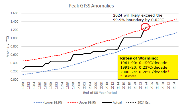
I agree with the AI-driven paper posted by @Typhoon Tip It is becoming increasingly evident that the rate of warming is increasing albeit not sharply. Earlier thinking that the warming was continuing to follow a general linear trajectory and that readings would quickly fall back once the strong 2023-24 El Niño event ended, is not supported by the recent evidence. The UN Global Emissions Gap report estimated that the world remains on track for 2.6°C-3.1°C warming by 2100. That report did not consider a potential increase in climate sensitivity, which would result in an increase in the rate of warming at higher levels of CO2. Emerging evidence suggests that the theoretical foundations of a dynamic Equilibrium Climate Sensitivity for a doubling of CO2 have grown stronger. Dynamic ECS is probably more likely than a fixed figure. Paleoclimate data from the Eocene found a higher ECS. The authors suggested that cloud-related feedbacks were largely responsible. Recent data shows cloud-related changes consistent with the earlier research now starting to take place. Those feedbacks provide insight into the dramatic jump in the global mean surface temperature during 2023 and persistently high temperature during 2024 despite a strong El Niño's giving way to neutral-cool ENSO conditions. The so-called "hot model" problem for the newer generation of climate models (CMIP6) was probably a reflection of those models' better assessment of cloud-related dynamics vs. earlier modeling than any flaw in the models. In any case, clouds are a positive feedback that amplifies warming. Further, if the rate of warming is increasing, one would expect to see linear estimates begin to break down. Below is a regression equation based on mean 30-year temperature anomalies and the highest 30-year anomaly during each period from 1980-2023, along with 99.9% confidence intervals. The 2024 global mean surface temperature anomaly will exceed the 99.9% confidence interval by an estimated 0.02°C (1.28°C vs. a 99.9% confidence limit of 1.26°C). This outcome is consistent with an increase in the rate of warming. In sum: The rate of warming has increased in recent years Cloud-related changes will likely amplify warming (not reduce it as some earlier hypotheses had speculated) Cloud-related changes will increase climate sensitivity The AI-based paper's conclusion appears to be consistent with the real world data The UN Gap Emission's range of 2.6°C-3.1°C warming by 2100 could modestly understate the degree of warming likely, especially in light of the failed COP 29 conference that failed even to mention fossil fuels
-
For those who are interested, the underlying paper is here: https://agupubs.onlinelibrary.wiley.com/doi/full/10.1029/2024GL111832
-
I suspect that the recent evidence of declining albedo on account of cloud-related changes has essentially put the debate to rest about the impact of clouds. Cloud-related changes will have a positive feedback (amplify warming). The earlier hypothesis that clouds could offset some of the warming is being proved incorrect by the most recent evidence.
-
Tomorrow will be a mild day with readings rising into the lower and middle 50s across the region. Temperatures could peak in the upper 50s and lower 60s as far north as southern New England on Wednesday. A larger storm will affect the region late tomorrow night into Thursday. The storm will likely bring a general 1"-2" rainfall. Some places could see locally higher amounts of up to 3" of rain. Following this storm, it will turn briefly noticeably colder Thursday and Friday before milder air starts to return during the weekend. The NAO fell to a preliminary -2.751 on September 24th (all-time September record: -2.371, September 12, 1971). That was the 9th lowest value on record. La Niña winters following September cases where the NAO fell to -1.900 or below featured a predominantly positive NAO. The most recent such winters were 2016-2017 and 2022-2023. The mean temperatures for those winters in New York City were 39.3° and 41.0° respectively. The 1991-2020 normal value is 36.2°. A warmer to much warmer than normal outcome is favored by the November run of the ECMWF for Winter 2024-2025. The ENSO Region 1+2 anomaly was +0.1°C and the Region 3.4 anomaly was -0.3°C for the week centered around December 4. For the past six weeks, the ENSO Region 1+2 anomaly has averaged +0.12°C and the ENSO Region 3.4 anomaly has averaged -0.20°C. Neutral ENSO conditions may still evolve into a La Niña event during the winter. Uncertainty as to whether a La Niña will actually develop continues to increase. Currently, 47% of dynamical models and 22% of the statistical models forecast the development of a La Niña. The SOI was +13.34 today. The preliminary Arctic Oscillation (AO) was -1.846 today. Based on sensitivity analysis applied to the latest guidance, there is an implied 59% probability that New York City will have a colder than normal December (1991-2020 normal). December will likely finish with a mean temperature near 38.0° (1.1° below normal).
-
Thanks. Yes, that’s true.
-
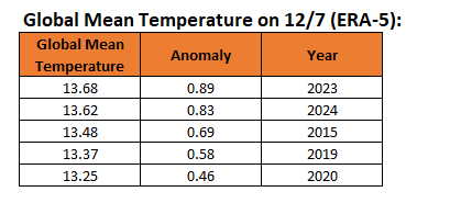
On ERA-5, global Temperature Anomalies are currently the second highest for 12/7 (most recent data for 2024). They are well above the 3rd highest value for this time of year.
-
Yes. I also, felt odds leaned cold in the East. From 11/24 in this thread: "Therefore, the odds are now tilted toward a cooler than normal December in the eastern third of the U.S. including such cities as Philadelphia, New York City, Buffalo, Chicago, Detroit, and Indianapolis, among others. Toronto could also wind up colder than normal."
-
Final Outcomes: The period was colder than normal but warmer than the guidance had implied.
-
Milder air surged back into the region to close the weekend. High temperatures included 55° in New York City and 59° in Philadelphia. Tomorrow and Tuesday will be somewhat cooler, but still on the mild side of normal. Temperatures could peak in the upper 50s and lower 60s into southern New England on Wednesday. A series of two storms will bring rain to accompany the return of milder temperatures. Tomorrow will likely see periods of rain with a general 0.25"-0.75" storm total. A larger storm will affect the region Wednesday into Thursday. At present, this storm could be capable of bringing widespread 1"-2" rainfall. Some places could see locally higher amounts of up to 3" of rain. Following two storms, it will turn briefly noticeably colder late in the week before milder air starts to return during the weekend. The NAO fell to a preliminary -2.751 on September 24th (all-time September record: -2.371, September 12, 1971). That was the 9th lowest value on record. La Niña winters following September cases where the NAO fell to -1.900 or below featured a predominantly positive NAO. The most recent such winters were 2016-2017 and 2022-2023. The mean temperatures for those winters in New York City were 39.3° and 41.0° respectively. The 1991-2020 normal value is 36.2°. A warmer to much warmer than normal outcome is favored by the November run of the ECMWF for Winter 2024-2025. The ENSO Region 1+2 anomaly was +0.3°C and the Region 3.4 anomaly was -0.3°C for the week centered around November 27. For the past six weeks, the ENSO Region 1+2 anomaly has averaged +0.07°C and the ENSO Region 3.4 anomaly has averaged -0.23°C. Neutral ENSO conditions may still evolve into a La Niña event during the winter. Uncertainty as to whether a La Niña will actually develop continues to increase. Currently, 47% of dynamical models and 22% of the statistical models forecast the development of a La Niña. The SOI was +17.07 yesterday. The preliminary Arctic Oscillation (AO) was -1.286 today. Based on sensitivity analysis applied to the latest guidance, there is an implied 64% probability that New York City will have a colder than normal December (1991-2020 normal). December will likely finish with a mean temperature near 37.8° (1.3° below normal).
-
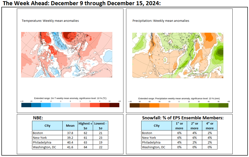
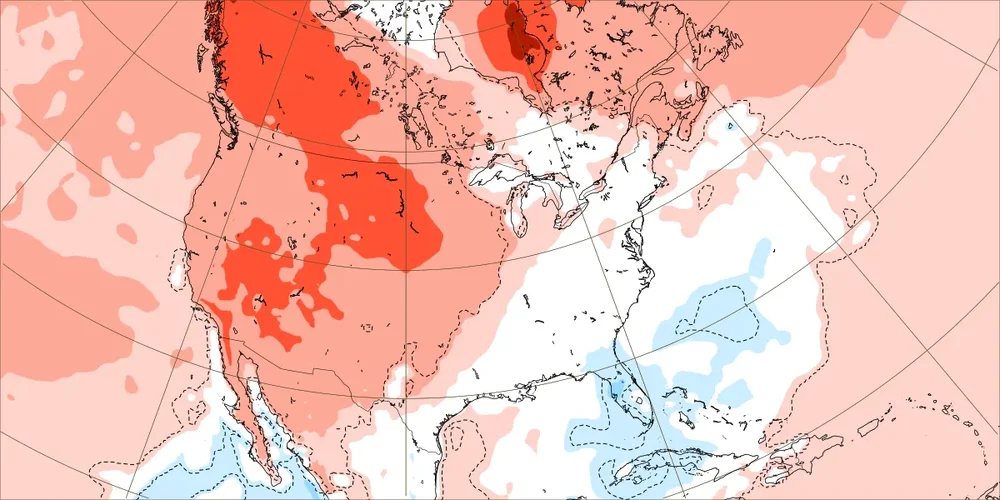
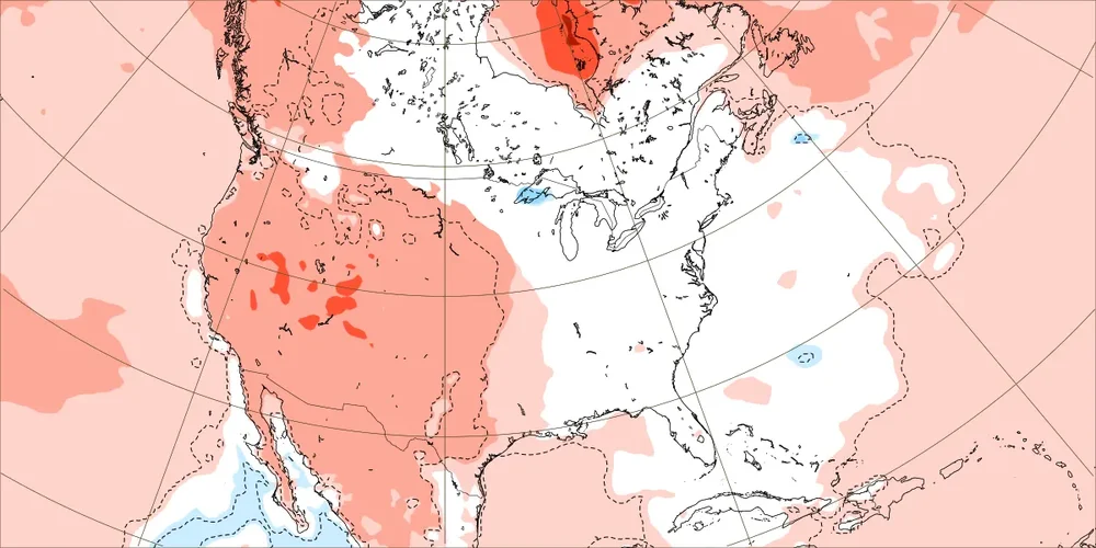
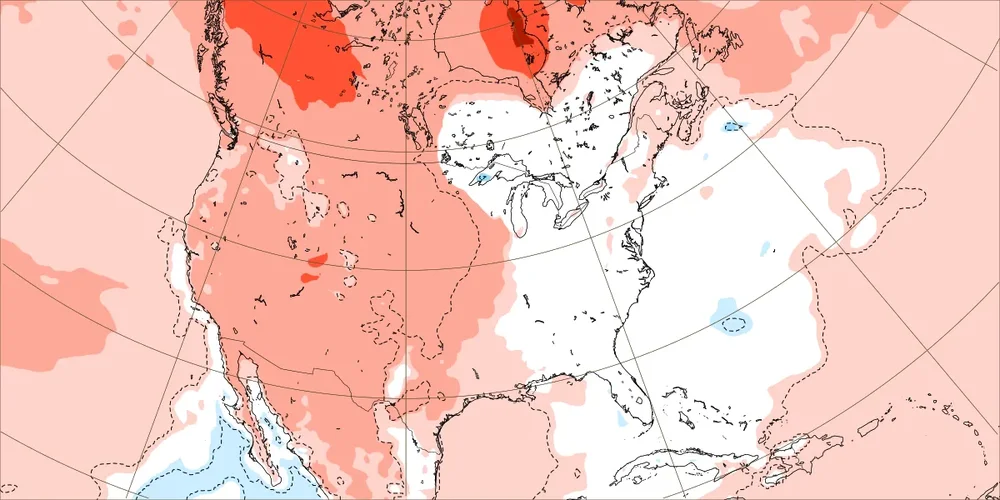
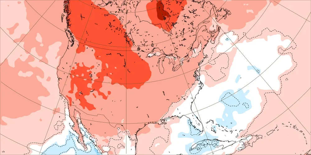
The last 7-10 days of December has remained a question mark. The 12/7 ECMWF weeklies were close to normal in the eastern half of the CONUS/Canada and warm in the western half. The CFSv2 was warmer than normal across almost all of North America. Nevertheless, some accounts on Social Media were spiking the proverbial football this afternoon for a much colder pattern even before anything had actually verified. Meanwhile, less than an hour after the festivities celebrating a dramatic turn toward a colder pattern for the Christmas/Hanukkah holiday had gotten underway, the ECMWF weeklies attempted to take away the punch bowl. Let's have a look: ECMWF 12/7 Run for 12/23-30: ECMWF 12/8 Run for 12/23-30: And how about for the following week? ECMWF 12/7 Run for 12/30-1/6: ECMWF 12/8 Run for 12/30-1/6: In reality, nothing much has changed in the larger forecasting scheme since the 0z runs. Some of the guidance has shifted colder, but the ECMWF weeklies went in the opposite direction. All of that could be noise prior to the models ultimately coming into agreement. All said, there's no major reason to move away from the idea that it could turn colder during the closing days of the month, while respecting that there is uncertainty concerning the timing of any shift should it occur. IMO, until there is sustained model commitment in one direction or the other, one should avoid prematurely verifying forecasts that may yet fail to verify. It's better to allow the passage of some time to get things right than to pre-verify an outcome that might never actually occur.
-
The cold start to December is on track, although readings in some places are milder than what had been shown on the guidance prior to the start of December. The first week of December saw temperatures in numerous locations in the East and Midwest average 6°-10° below normal. Some updates on last week's thoughts. 1. A clipper system brought a trace of snow to Washington, DC, New York City, and Boston. 2. Following the clipper, a number of cities in the eastern third of the U.S. experienced their lowest temperatures so far this season including Chicago, Cleveland, Detroit, Indianapolis, Norfolk, and Richmond. 3. British Columbia experienced much above normal temperatures. Five thoughts going forward: 1. A pattern change to milder weather still appears on track for mid-month. It will turn briefly very mild in the East on Tuesday and Wednesday, before another sharp cold shot brings much below normal temperatures for several days. 2. A storm will bring heavy rain to the Eastern Seaboard during late Tuesday into Thursday. An area running from Richmond to Boston could see widespread 1"-2" rainfall amounts with locally higher amounts of 3". Temperatures could surge to 60° or above in Washington, DC, Philadelphia, New York City, and perhaps Boston. Snowfall opportunities for the East Coast will remain limited through at least mid-month. 3. Minneapolis could see its first subzero low of the season on Thursday. Chicago and Milwaukee will likely experience their first single-digit temperatures of the season on Thursday. Detroit has a chance to drop below 10°. 4. After a short push of cooler air, Phoenix will see temperatures rebound into the 70s. Phoenix remains on track for a 78.3° annual mean temperature, which would surpass the existing mark of 77.3° from 2017 and 2020. 5. Overall, parts of the eastern third of the U.S. remain on course for a colder than normal December, even as the outcome of the closing week of the month remains uncertain (ECMWF weeklies are close to normal in the eastern half of the CONUS and Canada while the CFSv2 is warmer than normal across almost all of North America). Long-Range: There currently is a consensus among both long-range weekly tools that it could turn colder in early January (slower timing on the CFSv2). Supporting a faster arrival of colder air, the PNA is forecast to go positive around or just after mid-month. However, the EPO, NAO, and AO are forecast to remain largely neutral. That predominantly neutral state could persist into the start of January. The major fly in the ointment for the start of January is the risk that the PNA could go negative as shown on the 46-day EPS forecast. A PDO- supports a predominantly negative PNA. Were that outcome to verify, one could see the long-range guidance begin to shift the forecast area of cold westward as the late December period approaches. Finally, there is some disagreement among the extended GEFS and ECMWF concerning the dominant pattern regime from late December into January. The GEFS favors an Alaskan Ridge during the first week of January, which would feature colder weather in the East and warmer weather in the West. The extended ECMWF is split between an Alaskan Ridge and Pacific Ridge into mid-January. A Pacific Ridge favors cold in the West and warmth in the East. Based on the current conflicting guidance, I suspect that the first week of January could see cold redevelop, possibly even during the last few days of December, but rather than locking in initially, the pattern could feature variability. Whether the cold pattern will lock in or yield to a milder one afterward remains to be seen.
-
A wet week lies ahead. Midweek will be very mild before it turns sharply colder. Snowfall prospects will remain limited.

-
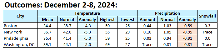
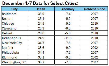
The first week of December concluded with a mean temperature of 34.7° in New York City. That was the coldest first week of December since 2007 when the mean temperature was 31.3°. Since 1980, every year with a first week December mean temperature below 38°, wound up with a monthly mean temperature below 39°. Since recordkeeping began in 1869, just 6 cases (9%) saw a monthly mean temperature of 39° or above after a first week mean below 38°. The warmest case in the period of record was 1971. The first week of December mean temperature was 34.6°. December finished with a monthly average temperature of 40.8°. Overall, the first week outcome suggests that December 2024 is on track to finish with a monthly average temperature below the normal figure of 39.1°. Baltimore, Boston, Philadelphia, and Washington, DC also saw their coldest first week of December since 2007. Richmond, which shivered under an 18° low this morning, experienced its coldest first week of December since 2002. Unlike in 2002 when Richmond saw 5.0" of snow during the first week of December, its 2024 chill occurred without any snowfall. Milder air will return to the region tomorrow to close the weekend. Temperatures could reach or exceed 50° in the northern Mid-Atlantic and southern New England areas by early next week. In addition, rainfall will likely accompany the return of milder temperatures. Monday night through Wednesday night looks particularly wet. Following the rainfall, it could turn briefly colder late in the week before milder air again returns. The NAO fell to a preliminary -2.751 on September 24th (all-time September record: -2.371, September 12, 1971). That was the 9th lowest value on record. La Niña winters following September cases where the NAO fell to -1.900 or below featured a predominantly positive NAO. The most recent such winters were 2016-2017 and 2022-2023. The mean temperatures for those winters in New York City were 39.3° and 41.0° respectively. The 1991-2020 normal value is 36.2°. A warmer to much warmer than normal outcome is favored by the November run of the ECMWF for Winter 2024-2025. The ENSO Region 1+2 anomaly was +0.3°C and the Region 3.4 anomaly was -0.3°C for the week centered around November 27. For the past six weeks, the ENSO Region 1+2 anomaly has averaged +0.07°C and the ENSO Region 3.4 anomaly has averaged -0.23°C. Neutral ENSO conditions may still evolve into a La Niña event during the winter. Uncertainty as to whether a La Niña will actually develop continues to increase. Currently, 47% of dynamical models and 22% of the statistical models forecast the development of a La Niña. The SOI was +17.07 today. The preliminary Arctic Oscillation (AO) was -0.761 today. Based on sensitivity analysis applied to the latest guidance, there is an implied 61% probability that New York City will have a colder than normal December (1991-2020 normal). December will likely finish with a mean temperature near 38.0° (1.1° below normal).
-
Cold enough for snow works for me.
-
That map should not have been posted. Were it 1 to maybe 2 weeks out, then things would be different.
-
It seems that it will turn colder for the start of January based on the latest guidance. But that doesn't mean that there necessarily will be the kind of historic outbreak of cold that BAMWX is calling for or the severe Arctic outbreak that Bastardi is mentioning for mid or late January. Even if a colder pattern seems likely, source regions will be critical, as will the degree of blocking to sustain it.