donsutherland1
-
Posts
24,196 -
Joined
Content Type
Profiles
Blogs
Forums
American Weather
Media Demo
Store
Gallery
Everything posted by donsutherland1
-
Occasional Thoughts on Climate Change
donsutherland1 replied to donsutherland1's topic in Climate Change
I believe we are now leaving the Holocene and perhaps have already left. It’s probably only a matter of time before geologists reach consensus. -
Week ahead outlook: The coming week will be a transitional period. Very mild weather will give way to progressively colder weather. Snowfall will still likely be limited in the Mid-Atlantic and southern New England areas.

-
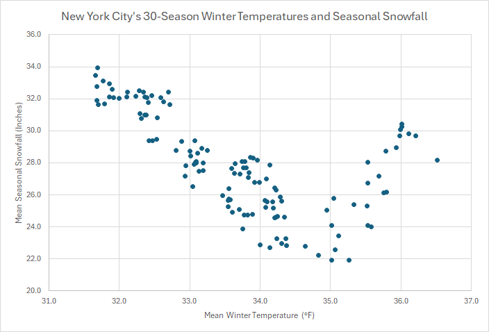
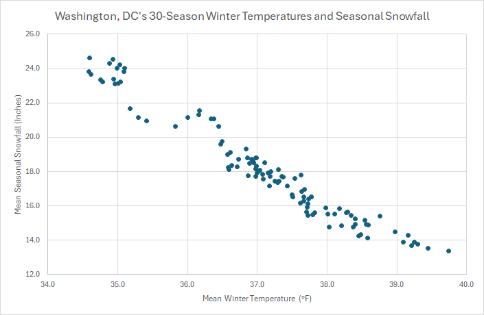
I suspect that it's a combination of both. It's too soon to be sure whether NYC is in the very early stages of a structural decline in snowfall from a warming climate. By the mid-2030s, it will probably be clear e.g., if NYC's seasonal snowfall has fallen to 20" or below (as suggested with regression analysis). Here's how NYC's 30-year mean snowfall stacks up against its 30-season winter mean temperatures: Here's Washington, DC's where seasonal snowfall has become structurally lower: Notice that both cities saw an increase as they approached mean winter temperatures of 36° that continued shortly afterward. NYC's decrease will likely be lower simply because NYC is closer to Canada and even in a warmer climate will see stronger shots of cold than Washington, DC. Both cities will remain capable of seeing big snowstorms, even as Washington's seasonal snowfall has declined and even if New York City's is in the early stages of a structural, non-cyclical decline. Both cities can still see very snowy winters. Winter 2009-10 in Washington, DC provides an example of multiple big snowstorms there and a very snowy winter despite a climate that had warmed by 1.4° over the prior 20 years.
-
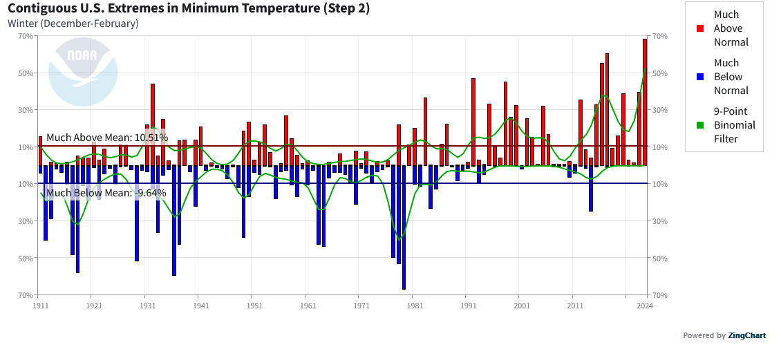
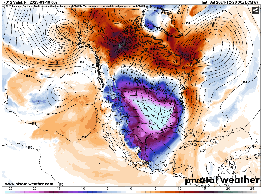
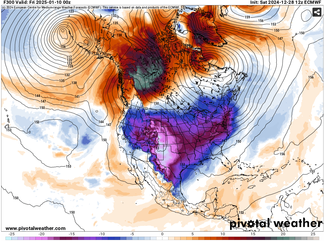
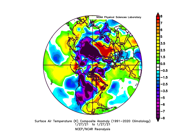
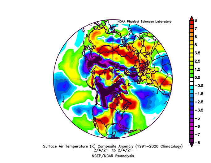
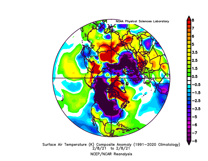
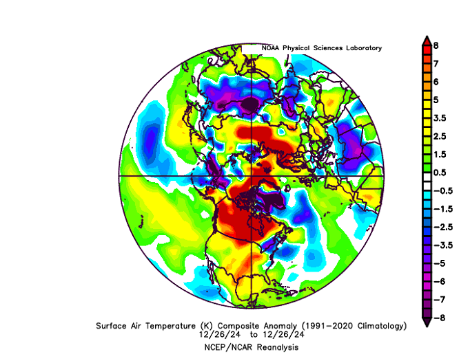
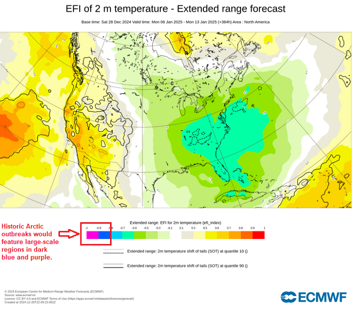
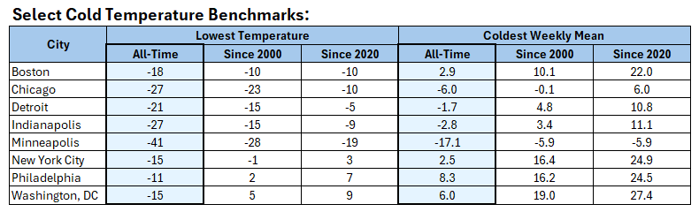
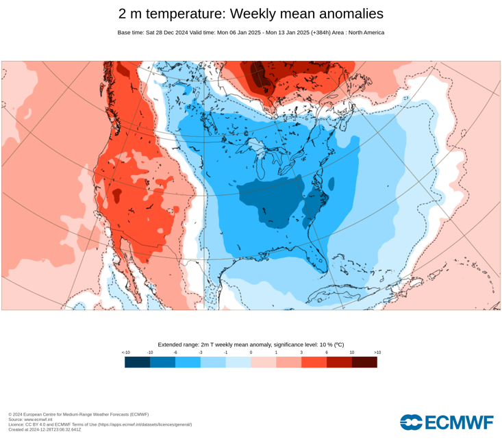
Increasingly, it appears that credible meteorological organizations and meteorologists are being drowned out by Social Media hype by amateurs and some of their own peers. The amateurs may not necessarily know better, but one would expect that the professionals would. But exaggerated posts (snowstorms, SSWs, and severe cold) in recent years hints otherwise. Last night, the 12/28 0z ECMWF operational model forecast a historic-type Arctic blast. Several professional accounts were among Social Media accounts trumpeting the model verbatim. At least one even specifically referred to "historic cold." A turn toward colder weather is likely in early January and the second week of January could be much colder than normal. But there is a large distinction between much colder than normal, a significant Arctic blast, and a historic-type Arctic blast. If one examines the bigger picture one finds: 1. Historic-type Arctic blasts have become less common as the Arctic region has warmed and the Northern Hemisphere's deep cold pool has shrunk. The last true historic large-scale Arctic blast occurred in February 11-20, 2021. 2. The climate has warmed, particularly since 2000. The ongoing warming is a big reason why the Contiguous U.S. has not seen a winter where excessively cold minimum temperatures have exceeded areal coverage of excessively warm minimum temperatures (winter average) since 2013-2014: Here are the Northern Hemisphere temperature anomalies 2 weeks and 1 week before the start of the February 2021 historic Arctic outbreak: 2 weeks: 1 week: 3 days: And here's the latest map (December 26, 2024): Key Difference: There was much more very cold air, both on our side of the Northern Hemisphere and the Northern Hemisphere overall prior to the February 2021 Arctic outbreak. It is unclear whether those accounts have much understanding of how to use ensembles, even as they almost certainly have awareness of ensembles. IMO, those accounts would do well to visit and study WPC's outstanding ensemble training page: https://www.wpc.ncep.noaa.gov/ensembletraining/ The WPC guide notes of operational model runs: "...in a chaotic system like an atmospheric model, non linear errors (although inconsequential in short lead times) will grow - sometimes rapidly. Eventually these growing errors cause the model forecast ouput to eventually become useless." That lesson is ignored or not well-understood by the accounts hyping historic cold outbreaks some 10 days or more in the future. If one looks at the latest ECMWF Extreme Forecast Index, one sees significant, but not historic cold is currently forecast: The very cold ECMWF weekly outlook for January 6-13: That's very cold. But it doesn't match the coldest shots since 2000 in Boston, Chicago, Detroit, Indianapolis, Minneapolis, New York City, Philadelphia, and Washington, DC. All said, the recent ECMWF weeklies, including today's run, is plenty cold to communicate the message that it will likely turn significantly colder in the long-range with the potential of a severe shot of cold. Exaggeration and hype are not needed. There is no need to invoke historic Arctic outbreaks that still have very little support (occasional runs on a single model, no run-to-run continuity, no widespread ensemble or other model support), especially at timeframes when operational model skill scores are low. Speaking of very little support, the 12/28 12z ECMWF still contains an Arctic outbreak during the second week of January, but it is nowhere near as frigid as the 12/28 0z run featured and pushed on Social Media by multiple accounts. And for the Social Media accounts that hyped the 0z run, no mention whatsoever about the 12z run? What is likely? January 10-20, will likely see the temperature fall well into the teens and perhaps even single digits in New York City and Philadelphia. Boston will likely see single digits with perhaps a chance at a subzero low. Detroit , Chicago, and Indianapolis could see one or more subzero lows. None of those cities will likely see historic-type cold e.g., widespread subzero lows from Washington, DC to Boston and double-digit subzero lows in Chicago, Indianapolis, and Detroit. Some of those cities might see their coldest readings of the 2020s, but most very likely won't exceed their coldest readings since 2000. Most or all of those cities likely won't experience their coldest 7-day period since 2000. Historic-type low temperatures and 7-day mean temperatures are unlikely. And if the cold fails to measure up to the coldest Arctic outbreaks since 2000, one can expect the Social Media accounts to still claim that they were "correct" in their assessment. However, in fact, their assessment would be wrong, as the cold wasn't even three-decade cold, much less historic-type cold. The general public will then come away with yet another example that skews their perceptions of the meteorology profession, lumping in outstanding public and private sector meteorologists with those who seek Social Media clicks and engagement.

-
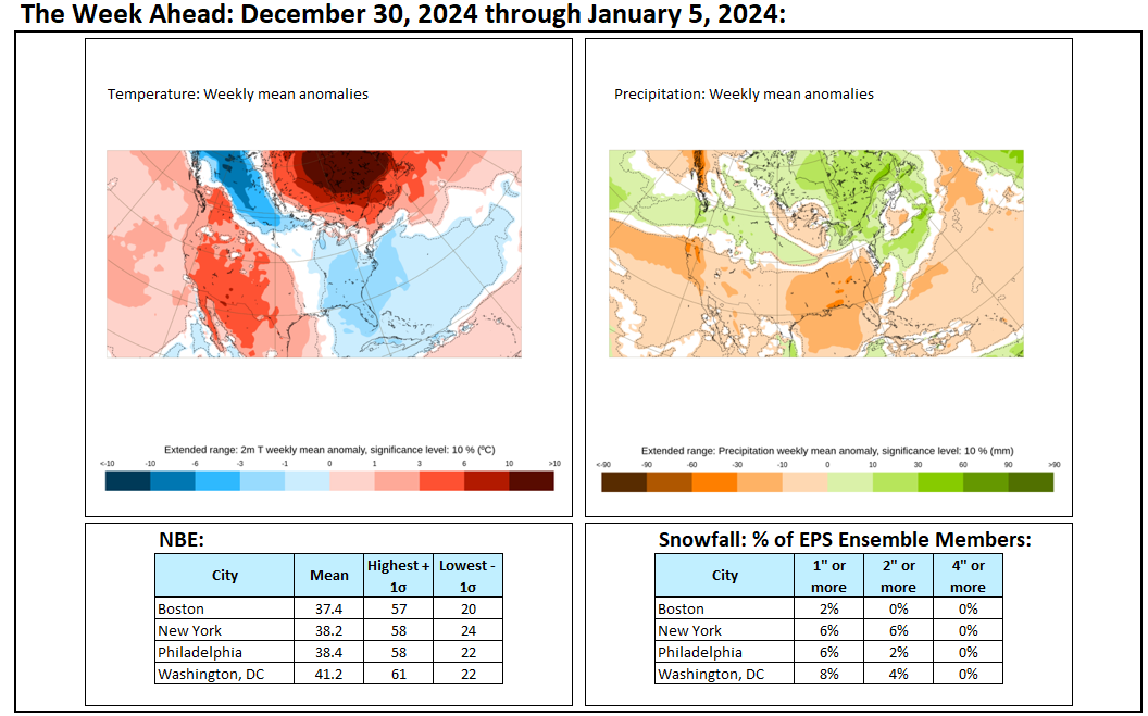
Warmer air began overspreading the region today. December will close with above to much above normal temperatures and additional periods of rain. The temperature will likely peak in the 60s in Washington, Baltimore, and Philadelphia and the 50s in New York City and Boston. The opening days of January will likely also begin with above normal temperatures, but it will start to turn colder. Snowfall prospects will remain limited through the end of December. However, the pattern could become more favorable for moderate or perhaps larger snowfalls as the cold returns during the first week of January. The second week of January will likely feature widespread cold anomalies in much of the eastern half of the CONUS and Canada south of the Hudson and James Bays. The potential exists for widespread cold anomalies of 6°-10° below normal during that week in that region. Should the AO dive below -3.000, the prospects for a significant or major snowfall in the New York City area could be reduced. Since 1950, a January AO ranging from -2.600 to -1.400 accounted for the largest share of 6" and 10" or above January snowfalls for storms that dumped 4" or more snow in New York City. For the 4" or above storms, 67% saw 6" or more while 56% went on to see 10" or more. When the AO was -3.000 or below, 60% of 4" or above snowstorms saw 6" or more snowfall, while 20% of those storms saw 10" or more. The exact synoptic details will be crucial to determining whether that potential will be realized. On account of a lack of snowfall, 2023-2024 will set new records for the lowest snowfall over a two-year period for Boston and New York City. Boston: 2023-2024 Total to Date: 26.9"; Record: 38.2", 1979-1980 New York City: 2023-2024 Total to Date: 12.6"; Record: 17.4", 1997-1998 The NAO fell to a preliminary -2.751 on September 24th (all-time September record: -2.371, September 12, 1971). That was the 9th lowest value on record. La Niña winters following September cases where the NAO fell to -1.900 or below featured a predominantly positive NAO. The most recent such winters were 2016-2017 and 2022-2023. The mean temperatures for those winters in New York City were 39.3° and 41.0° respectively. The 1991-2020 normal value is 36.2°. A warmer to much warmer than normal outcome was favored by the November run of the ECMWF for Winter 2024-2025. Even as the NAO outlook appears on course to be relatively accurate, Winter 2024-2025 will likely wind up being notably colder than the subset of winters listed above. The ENSO Region 1+2 anomaly was -0.2°C and the Region 3.4 anomaly was -0.8°C for the week centered around December 18. For the past six weeks, the ENSO Region 1+2 anomaly has averaged +0.17°C and the ENSO Region 3.4 anomaly has averaged -0.35°C. Neutral ENSO conditions may still evolve into a La Niña event during the winter. Uncertainty as to whether a La Niña will actually develop persists. On the December 19 outlook, 56% of dynamical models but 0% of the statistical models forecast the development of a La Niña. The SOI was +4.72 today. The preliminary Arctic Oscillation (AO) was +0.373 today. Based on sensitivity analysis applied to the latest guidance, there is an implied near 100% probability that New York City will have a colder than normal December (1991-2020 normal). December will likely finish with a mean temperature near 37.7° (1.4° below normal).
-
Occasional Thoughts on Climate Change
donsutherland1 replied to donsutherland1's topic in Climate Change
The debate concerning the Medieval Warm Period and its comparison to the contemporary warming was largely put to rest in 2019. No period during the past 2,000 years even begins to compare to the magnitude and expanse of warmth seen during the current warm period. https://www.nature.com/articles/s41586-019-1401-2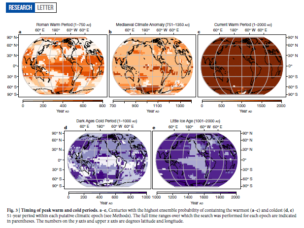
-
Just so it's clear, my reference to a possible Arctic blast during the second week of January does not necessarily mean that it would be a historic shot of cold. It could still be the strongest shot of cold in parts of the Great Lakes region and Northeast, but that is not assured from this far out. Indeed, the 12/28 0z ECMWF backed off from the magnitude of cold shown on the 12/28 0z run. 12/28 0z ECMWF at 312 hours (850 mb anomalies °C): 12/28 12z ECMWF at 300 hours (850 mb anomalies °C): In terms of snowfall, a significant number of ensemble members show varying amounts of snowfall during January 6-12. If there will be a significant event, one would expect to see the ensemble members begin to converge on their timing for such an event. A large spread over dates typically favors lighter events in the short-range. In the medium- and long-range a large spread typically exists due to timing uncertainty.


-
Some updates on last week’s thoughts: 1. The eastern U.S. experienced its coldest weather so far this season. Lowest temperatures included: Albany: -5°, Allentown: 1°, Boston: 10°, Harrisburg: 10°, Hartford: 5°, New York City: 13°, Newark: 11°, Philadelphia: 11°, Poughkeepsie: -2°, Providence: 9°, and Washington, DC: 21°. This cold spell brought the first teens of the winter to New York City and Philadelphia. 2. Noticeably milder weather returned to the Great Lakes Region on Monday (in Chicago) and Tuesday (Detroit). Temperatures averaged more than 10° above normal in Chicago and Detroit on Thursday and Friday. Friday saw a high temperature of 52° in Chicago with a mean temperature that was 20.7° above normal. The milder air started moving into the Mid-Atlantic and southern New England regions on Friday and Saturday, which was somewhat delayed. 3. Snowfall remained limited from Washington, DC to Philadelphia. Snowfall totals for the week were: Baltimore: Trace; New York City: 1.0”; Philadelphia: 0.2”; and, Washington, DC: 0.1”. No additional snowfall is likely through the end of December in any of those cities. 4. The Pacific Northwest was warmer to much warmer than normal during the week. All days were above to much above normal in Portland. Seattle had a single below normal day (-0.1° below normal). It was also wet. The 1.11” that fell at Portland on December 25th was the second highest daily amount for that date. Five Thoughts Going Forward: 1. Detroit and Chicago will see 50° or above highs today and tomorrow, but a colder pattern will begin to develop on January 1 or 2. 2. Baltimore, Philadelphia, and Washington, DC will see highs that peak at 60° or above tomorrow and /or Monday. A colder pattern will begin to develop during January 2-3. 3. Snowfall prospects for the Great Lakes Region and Mid-Atlantic/southern New England regions will remain very limited for the week. 4. Phoenix will conclude its warmest year on record with an annual mean temperature of 78.6° (old record: 77.3°, 2017 and 2020) with its warmest December on record. Phoenix will tie its record for most consecutive lows of 40° or above (353 days, January 7 through December 25, 2014) on December 31st and then break that record the following day. 5. Blythe, CA will further extend its record 270-day stretch without measurable precipitation through the coming week. Longer-Range: A cold pattern will develop during the first week of January. The second week of January has the potential to feature widespread colder-than-normal readings before slow moderation develops near or after mid-month. An Arctic blast is possible during the second week of January. The pattern will likely become more conducive toward bigger snowfalls in the Great Lakes Region eastward to the Middle Atlantic and New England states. Whether there will be storminess to coincide with the cold will remain to be seen, as some of the long-range guidance keeps conditions relatively dry through at least the first week of January. Ensemble members hint that the January 6-12 timeframe might offer a window for storminess from the Middle Atlantic area into New England. The AO-/PNA+ pattern forecast up to at least January 20th on the latest guidance accounts for a disproportionate share of moderate or significant snowfalls in the Mid-Atlantic region. Some of the long-range guidance suggests that an EPO+/AO+/PNA- pattern could develop in late January. The change in teleconnections could coincide with the emergence of an AAM- regime. That would imply that the month of January could end with warmer than normal readings. Teleconnection forecasts beyond two weeks are not skillful.
-
E PA/NJ/DE Winter 2024/25 Obs/Discussion
donsutherland1 replied to JTA66's topic in Philadelphia Region
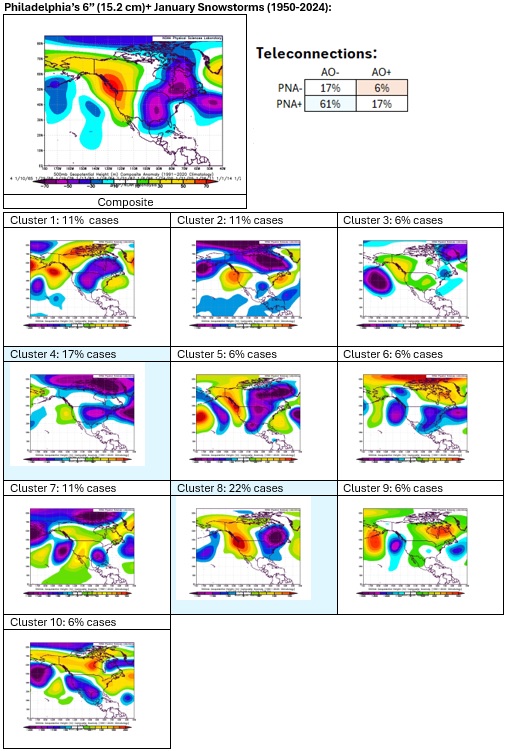
For reference, 500 mb patterns associated with 6"+ January snowstorms in Philadelphia: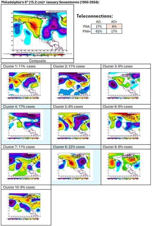
-
It will turn noticeably milder tomorrow as wetter weather moves in. New York City's northern and western suburbs could see some freezing rain late tonight or early tomorrow morning. By late in the day, the temperature will push into the lower and middle 40s in New York City December will close with above normal temperatures and additional periods of rain. The temperature will likely peak in the 60s in Washington, Baltimore, and Philadelpia and the 50s in New York City and Boston. The opening days of January will likely also begin with above normal temperatures, but it will start to turn colder. Snowfall prospects will remain limited through the end of December. However, the pattern could become more favorable for moderate or perhaps larger snowfalls as the cold returns during the first week of January. The second week of January will likely feature widespread cold anomalies in much of the eastern half of the CONUS and Canada south of the Hudson and James Bays. The potential exists for widespread cold anomalies of 6°-10° below normal during that week in that region. On account of a lack of snowfall, 2023-2024 will likely set a new records for the lowest snowfall over a two-year period for Boston and New York City. Boston: 2023-2024 Total to Date: 26.7"; Record: 38.2", 1979-1980 New York City: 2023-2024 Total to Date: 12.6"; Record: 17.4", 1997-1998 The NAO fell to a preliminary -2.751 on September 24th (all-time September record: -2.371, September 12, 1971). That was the 9th lowest value on record. La Niña winters following September cases where the NAO fell to -1.900 or below featured a predominantly positive NAO. The most recent such winters were 2016-2017 and 2022-2023. The mean temperatures for those winters in New York City were 39.3° and 41.0° respectively. The 1991-2020 normal value is 36.2°. A warmer to much warmer than normal outcome is favored by the November run of the ECMWF for Winter 2024-2025. The ENSO Region 1+2 anomaly was -0.2°C and the Region 3.4 anomaly was -0.8°C for the week centered around December 18. For the past six weeks, the ENSO Region 1+2 anomaly has averaged +0.17°C and the ENSO Region 3.4 anomaly has averaged -0.35°C. Neutral ENSO conditions may still evolve into a La Niña event during the winter. Uncertainty as to whether a La Niña will actually develop persists. On the December 19 outlook, 56% of dynamical models but 0% of the statistical models forecast the development of a La Niña. The SOI was -0.57 today. The preliminary Arctic Oscillation (AO) was +0.650 today. Based on sensitivity analysis applied to the latest guidance, there is an implied 99% probability that New York City will have a colder than normal December (1991-2020 normal). December will likely finish with a mean temperature near 37.4° (1.7° below normal).
-
It’s not a snow threat for the NYC area.
-
Its verification requires a major snowstorm. We’ll have to see if things come together. Such storms are uncommon.
-
The teleconnections are forecast to move into a combination that has often been associated with moderate or significant snowstorms in New York City. Based on the 12/27 0z EPS and latest 46-day ECMWF forecast, the teleconnections could be in a favorable state through January 20th. Moderate or significant snowfalls are still infrequent events. Assuming that the favorable combination occurs and persists through January 20th, one will need to look for additional factors: - Sufficient cold: Likely through most of the period - Short waves that could become storms: Multiple candidates on the guidance through 15 days - Synoptic details: TBD (can't be reliably forecast beyond 5-7 days) With the ENSO being in a neutral-cool phase, the active subtropical jet stream that is conducive to the development of Miller A storms is less prominent. At present, the potential for at least moderate (4" or above) snowfalls will become more favorable than it has been during all of the winter so far. However, the potential still needs to be realized. Based on the statistics (1950-2024), here's what seems plausible right now for the January 1-20 period: - Measurable snowfalls: 2-4 days - 1" or more snowfall: 1-3 days - 2" or more snowfall: 1-2 days - 4" or more snowfall: 1 day Moderate snowfalls: 1 to perhaps 2 Significant snowfalls: Maybe 1
-
The cold will begin to recede toward the end of the week as wetter weather moves in. New York City's northern and western suburbs could see some freezing rain late tomorrow night or early Saturday morning. December will close with above normal temperatures and periods of rain. The temperature will likely peak in the 60s in Washington, Baltimore, and Philadelpia and the 50s in New York City and Boston. The opening days of January will likely also begin with above normal temperatures, but it will start to turn colder. Snowfall prospects will remain limited through the end of December. However, the pattern could become more favorable for moderate or perhaps larger snowfalls as the cold returns during the first week of January. There is growing potential for the second week of January to feature widespread cold anomalies in much of the eastern half of the CONUS and Canada south of the Hudson and James Bays. On account of a lack of snowfall, 2023-2024 will likely set a new records for the lowest snowfall over a two-year period for Boston and New York City. Boston: 2023-2024 Total to Date: 26.7"; Record: 38.2", 1979-1980 New York City: 2023-2024 Total to Date: 12.6"; Record: 17.4", 1997-1998 The NAO fell to a preliminary -2.751 on September 24th (all-time September record: -2.371, September 12, 1971). That was the 9th lowest value on record. La Niña winters following September cases where the NAO fell to -1.900 or below featured a predominantly positive NAO. The most recent such winters were 2016-2017 and 2022-2023. The mean temperatures for those winters in New York City were 39.3° and 41.0° respectively. The 1991-2020 normal value is 36.2°. A warmer to much warmer than normal outcome is favored by the November run of the ECMWF for Winter 2024-2025. The ENSO Region 1+2 anomaly was -0.2°C and the Region 3.4 anomaly was -0.8°C for the week centered around December 18. For the past six weeks, the ENSO Region 1+2 anomaly has averaged +0.17°C and the ENSO Region 3.4 anomaly has averaged -0.35°C. Neutral ENSO conditions may still evolve into a La Niña event during the winter. Uncertainty as to whether a La Niña will actually develop persists. On the December 19 outlook, 56% of dynamical models but 0% of the statistical models forecast the development of a La Niña. The SOI was +5.66 today. The preliminary Arctic Oscillation (AO) was +0.684 today. Based on sensitivity analysis applied to the latest guidance, there is an implied 97% probability that New York City will have a colder than normal December (1991-2020 normal). December will likely finish with a mean temperature near 37.2° (1.9° below normal).
-
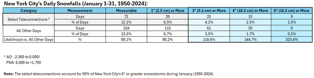
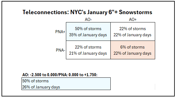
Here's the data that includes percentages of January days with the select teleconnections.
-
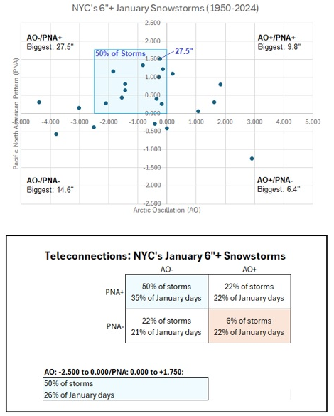
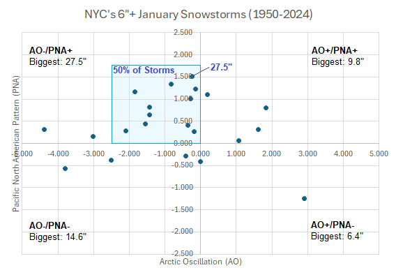
An AO-/PNA+ pattern is forecast to prevail through at least the first 7-10 days of January. These patterns accounted for a disproportionate share of 6"+ snowstorms for New York City during January 1-31, 1950-2024. The AO -2.500 to 0.000/PNA 0.000 to +1.750 ranges account for 50% of such events in January. The teleconnections do not guarantee significant snowstorm. Things that will be critical: 1. Whether there are short waves that could become storms 2. The 500 mb pattern 3. Placement of synoptic features 4. A sufficiently cold air mass The potential for at least a moderate (4" or above) snowstorm will be greater than it has been during all of December. It remains to be seen whether the potential will be realized.
-
That's a good point. @bluewave. I just looked it up now.
-
January: Medium/ Long Range: May the Force be with Us....
donsutherland1 replied to Weather Will's topic in Mid Atlantic
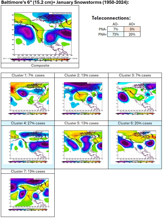
Baltimore's 6"+ January Snowstorms (1950-2024):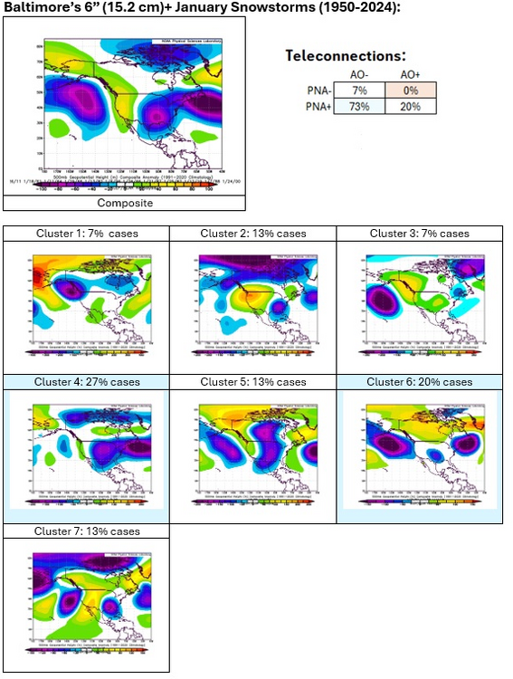
-
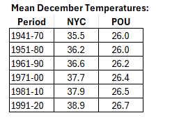
NYC would drop 0.4° were December 2015 eliminated from the data.
-
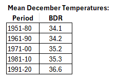
I suspect that NYC's proximity to a warming ocean may be the larger driver than UHI. For example, Bridgeport has also seen a large increase in December temperatures during recent years. Apparently, the POU site has moved around a number of times. That may also impact the POU numbers. See @bluewave's post.
-
January: Medium/ Long Range: May the Force be with Us....
donsutherland1 replied to Weather Will's topic in Mid Atlantic
Yes, the clusters were only based off the 18 DCA cases. I was looking at significant snowfalls. Had I used the 4" cutoff, there would have been 24 cases. -
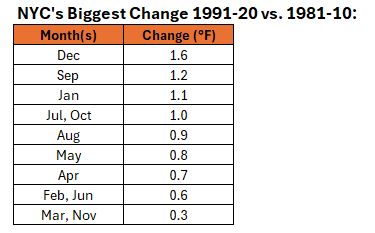
1991-20 is much warmer than 1981-10. December 2015 played a big role in contributing to that outcome.
-
January: Medium/ Long Range: May the Force be with Us....
donsutherland1 replied to Weather Will's topic in Mid Atlantic
I will post BWI and PHL in the next day or two. I have company here. -
January: Medium/ Long Range: May the Force be with Us....
donsutherland1 replied to Weather Will's topic in Mid Atlantic
The suburbs do better, as does IAD.