donsutherland1
-
Posts
24,197 -
Joined
Content Type
Profiles
Blogs
Forums
American Weather
Media Demo
Store
Gallery
Everything posted by donsutherland1
-
Last measurable: 0.1", Deember 26, 2022; Last storm with 1" or more: January 16-17, 2018: 2.4" (2.3" fell on January 17).
-
Atlanta has gone over to light snow.
-
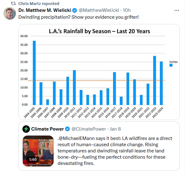
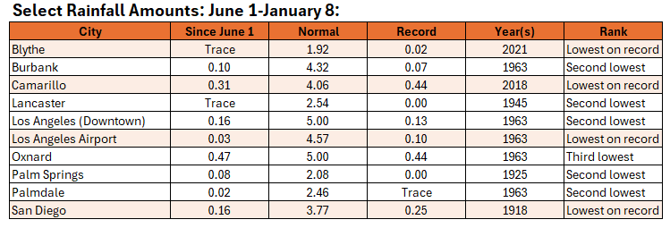
Even as the flames of wildfires ringing the Los Angeles area in hellish fashion have consumed some 4,000 structures, climate change deniers are exploiting the catastrophe to push disinformation. Let's take a quick look. Neither Wielicki nor Martz has sufficient understanding of weather and climate to analyze what has actually taken place. Instead, both push the common fallacy that rainfall in the past (last 20 winters, in this case) means there can't possibly be a drought, much less severe wildfire conditions. Now the facts: 1. Los Angeles County is in the midst of a moderate or severe drought, as is much of southern California. Moreover, drought conditions were growing rapidly worse. The latest data: 2. Rainfall in past winters means nothing. That rainfall is in the distant past. What matters is how much rain has recently fallen. Many locations have had either their second lowest or lowest rainfall on record since June 1. Through yesterday, Blythe has gone a record 282 consecutive days without measurable rainfall. Lancaster has gone 238 consecutive days without measurable rainfall (second longest such streak). 3. Flash droughts, which can develop in as few as five days are becoming increasingly frequent due to climate change. Two papers: A global transition to flash droughts under climate change Global projections of flash drought show increased risk in a warming climate Increased risk of flash droughts with raised concurrent hot and dry extremes under global warming 4. Climate change is also driving an increase in the vapor pressure deficit leading to more intense and extreme wildfires. One paper: Quantifying contributions of natural variability and anthropogenic forcings on increased fire weather risk over the western United States 5. The literature has made abundantly clear that climate change is leading to an increased wildfire risk in southern California. A key paper: The season for large fires in Southern California is projected to lengthen in a changing climate Two Key Points: 1. Neither person cited in the opening has the background knowledge or information to make an informed judgment about weather, climate, or the antecedent conditions responsible for southern California's catastrophic wildfires. Their reasoning about past precipitation was fallacious. Both had no idea that the region was currently in a drought or any awareness that drought products exist and can readily be accessed by the public. They appear to have no knowledge of the concept of flash droughts, thus there flawed argument about past winters' rainfall. They are unfamiliar with the literature on the role of climate change in driving flash droughts, increased vapor pressure deficits, and on the wildfire risk to southern California. 2. At a time of great danger and terrible tragedy, such ill-informed social media accounts should refrain from pushing disinformation, if just for ethical reasons. Their misleading people--including those at risk of the wildfires or victims of the fires--can put lives at risk. It can also increase the emotional distress being experienced among those who have already lost much in the raging fires.


-
Guidance raised it. It's based purely on the guidance.
-
Today was fair, very windy, and continued cold, although the mercury topped out at 33° in Central Park. Clouds could incrase tomorrow afternoon or evening as a storm passes well south and east of the region. There could be some snow flurries or snow showers tomorrow night into Saturday. Any accumulations will be small. Before then, the storm has the potential to bring Atlanta a minor accumulation of snow on Friday into Saturday. The last time Atlanta experienced a measurable snowfall was December 26, 2022 when 0.1" snow fell. In most cases, Atlanta's snowfalls don't result in much snowfall in the New York City area. For example, since 1950, Atlanta has seen 17 January snowstorms of 1" or more. In 12 (71%) of those cases, New York City saw less than 0.5" of snow, including 8 (47%) cases with no measurable snowfall. An extended period of generally below normal temperatures is underway in the New York City area. Although this cold regime will likely extend through at least the first three weeks of January, the kind of severe cold that produces minimum temperatures below 10° in the Philadelphia to New York City areas is unlikely during that period. The cold could still peak with readings dropping into the teens and several subfreezing highs. The third week of January will likely feature a continuation of widespread cold anomalies in much of the eastern half of the CONUS and Canada south of the Hudson and James Bays. Those anomalies will likely result more from the prolonged nature of the cold than its severity. However, notable exceptions could be areas with fresh snow cover that experience strong radiational cooling. Moderation is possible during the closing week of the month. The ENSO Region 1+2 anomaly was +0.1°C and the Region 3.4 anomaly was -0.7°C for the week centered around January 1. For the past six weeks, the ENSO Region 1+2 anomaly has averaged +0.02°C and the ENSO Region 3.4 anomaly has averaged -0.63°C. La Niña conditions are underway and will likely persist into the start of spring. The SOI was -4.75 today. The preliminary Arctic Oscillation (AO) was -1.784 today. Based on sensitivity analysis applied to the latest guidance, there is an implied 80% probability that New York City will have a colder than normal January (1991-2020 normal). January will likely finish with a mean temperature near 30.5° (3.2° below normal).
-
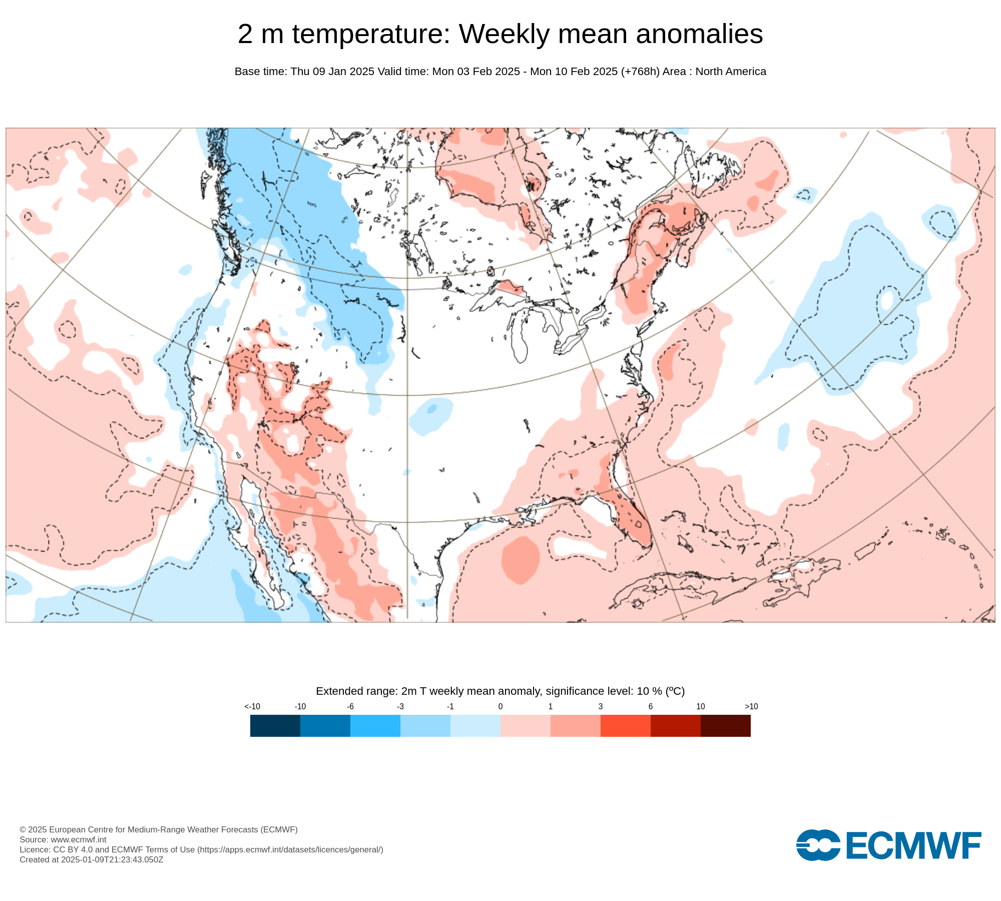
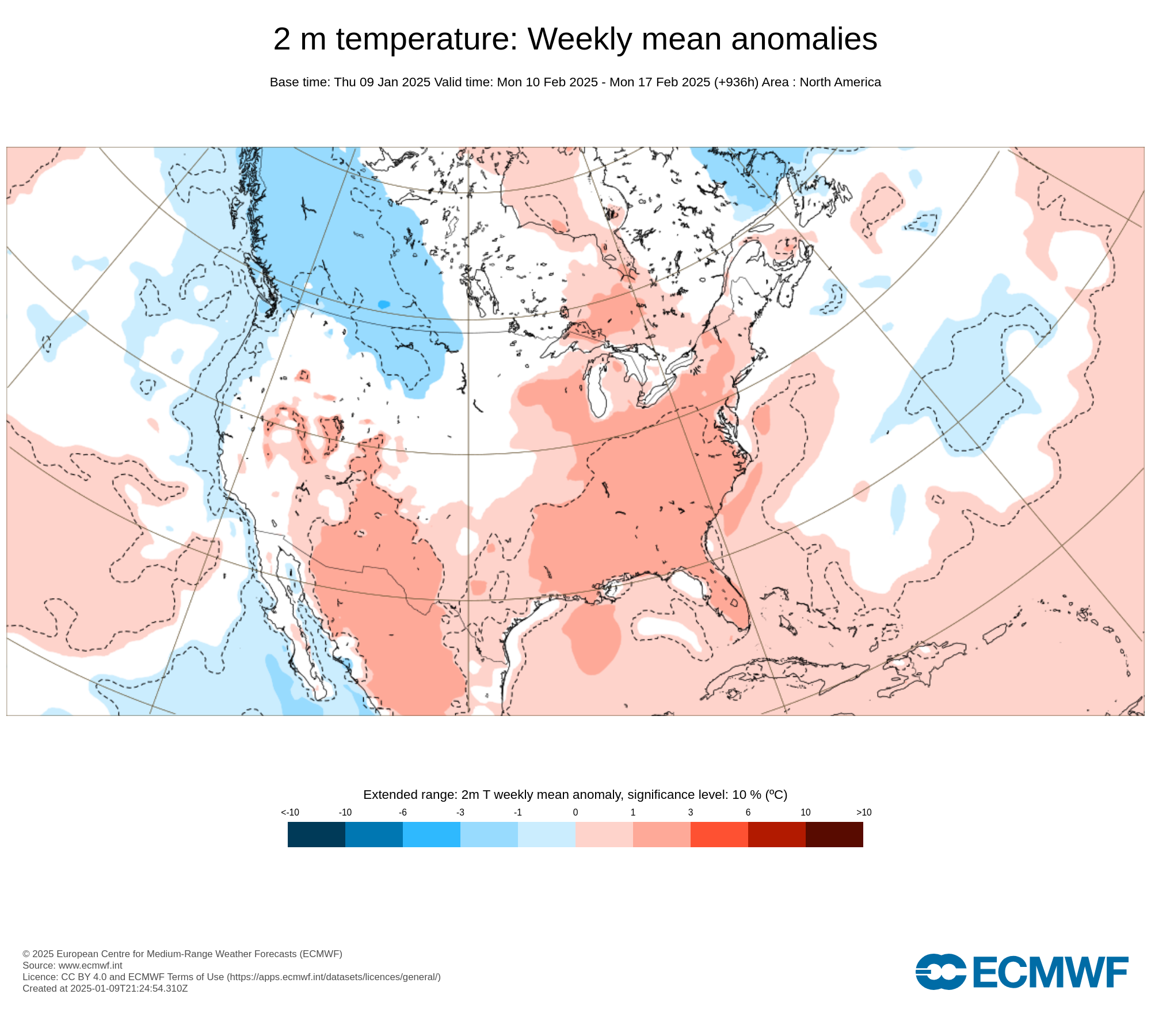
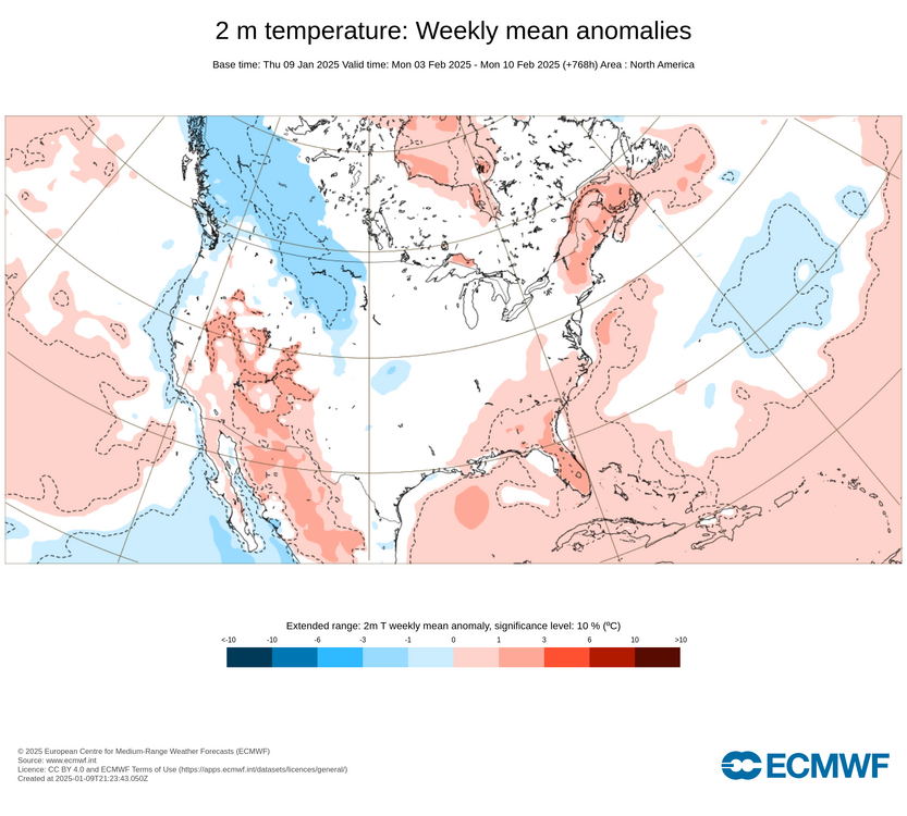
The ECMWF weeklies for weeks 4 and 5 from the ECMWF's site are as follows (I believe those are the maps W. Drag referenced):

-
For reference: https://www.weather.gov/lwx/events_Inauguration
-
Thanks for this info. I had been waiting for the official announcement.
-
There can be differences in the trajectory e.g., Washington, DC has a direct shot of Arctic air. I'm not sure if the tool allows the use of multiple endpoints.
-
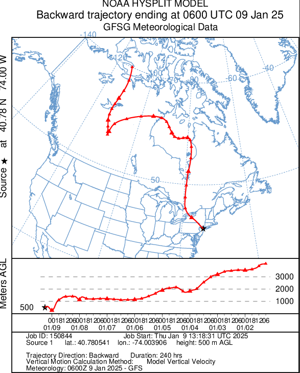
The source region of today's air mass:
-
There is a fixed baseline for the long-term climate. For example, GISS uses 1951-80. NOAA uses 1901-99. The climate "normals" serve a different purpose. Their purpose is to convey information what the present climate of a location is like. That's why the climate normals are updated every 10 years (not just in the U.S., but worldwide).
-
Today was another windy and cold day. Most of the rest of the week will feature generally quiet weather in terms of precipitation. There will be a gusty wind, at times. A developing coastal storm could graze parts of the region during the weekend. Any accumulations will be small. Before then, the storm has the potential to bring Atlanta a minor accumulation of snow on Friday into Saturday. The last time Atlanta experienced a measurable snowfall was December 26, 2022 when 0.1" snow fell. An extended period of generally below normal temperatures is underway in the New York City area. Although this cold regime will likely extend through at least mid-month, the kind of severe cold that produces minimum temperatures below 10° in the Philadelphia to New York City areas is unlikely during that period. The cold could still peak with readings dropping into the teens and several subfreezing highs. The second and third weeks of January will likely feature widespread cold anomalies in much of the eastern half of the CONUS and Canada south of the Hudson and James Bays. The potential exists for widespread cold anomalies of 6°-10° below normal during that week in parts of that region, particularly the Southeast. Those anomalies will likely result more from the prolonged nature of the cold than its severity. However, notable exceptions could be areas with fresh snow cover that experience strong radiational cooling. The ENSO Region 1+2 anomaly was +0.1°C and the Region 3.4 anomaly was -0.7°C for the week centered around January 1. For the past six weeks, the ENSO Region 1+2 anomaly has averaged +0.02°C and the ENSO Region 3.4 anomaly has averaged -0.63°C. Neutral ENSO conditions may still evolve into a La Niña event during the winter. Uncertainty as to whether a La Niña will actually develop persists. On the December 19 outlook, 56% of dynamical models but 0% of the statistical models forecast the development of a La Niña. The SOI was -3.53 today. The preliminary Arctic Oscillation (AO) was -2.332 today. Based on sensitivity analysis applied to the latest guidance, there is an implied 80% probability that New York City will have a colder than normal January (1991-2020 normal). January will likely finish with a mean temperature near 30.3° (3.4° below normal).
-
Jan 11th-12th Super Bomb or Super Bummed?
donsutherland1 replied to Rjay's topic in New York City Metro
The NAO has been negative since January 2.- 993 replies
-
- 5
-

-
- metsfan vs snowman
- bomb
- (and 2 more)
-
It hasn't happened (at least not yet).
-
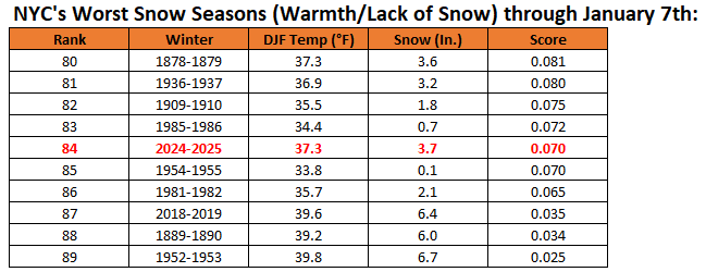
Although snowfall has been disappointing in the New York City area so far, Winter 2024-2025 ranks vastly better than the past two winters in terms of the combination of cold and snow through January 7th. Winter 2022-2023 finished as the second worst (only exceeded by 2001-2002) in terms of warmth and lack of snowfall. Winter 2023-2024 finished as the fourth worst. In contrast, Winter 2024-2025 currently ranks 84th worst, just marginally worse than Winter 1954-1955.
-
I believe it will be tough for January to average below 30° in NYC. We're really not getting cross-polar flow. When the pattern begins to break down late in the month, it will turn milder.
-
Final snowfalls from the January 5-6, 2025 Mid-Atlantic snowstorm included: Baltimore: 6.6" Bridgeport: 0.4" Islip: 0.4" New York City: 0.9" Newark: 0.8" Philadelphia: 1.8" Richmond: 6.0" Washington, DC: 7.2" The last storm to bring 6" or more snow to Baltimore, Richmond, and Washington, DC occurred during January 22-24, 2016. In the wake of the recent snowstorm, the rest of the week will feature quieter weather in terms of precipitation. There will be a gusty wind, at times. A developing coastal storm could graze parts of the region during the weekend. Before then, the storm has the potential to bring Atlanta a minor accumulation of snow on Friday into Saturday. The last time Atlanta experienced a measurable snowfall was December 26, 2022 when 0.1" snow fell. An extended period of generally below normal temperatures is underway in the New York City area. Although this cold regime will likely extend through at least mid-month, the kind of severe cold that produces minimum temperatures below 10° in the Philadelphia to New York City areas is unlikely during that period. The cold could still peak with readings dropping into the teens and several subfreezing highs. The second and third weeks of January will likely feature widespread cold anomalies in much of the eastern half of the CONUS and Canada south of the Hudson and James Bays. The potential exists for widespread cold anomalies of 6°-10° below normal during that week in parts of that region, particularly the Southeast. Those anomalies will likely result more from the prolonged nature of the cold than its severity. However, notable exceptions could be areas with fresh snow cover that experience strong radiational cooling. The ENSO Region 1+2 anomaly was +0.1°C and the Region 3.4 anomaly was -0.7°C for the week centered around January 1. For the past six weeks, the ENSO Region 1+2 anomaly has averaged +0.02°C and the ENSO Region 3.4 anomaly has averaged -0.63°C. Neutral ENSO conditions may still evolve into a La Niña event during the winter. Uncertainty as to whether a La Niña will actually develop persists. On the December 19 outlook, 56% of dynamical models but 0% of the statistical models forecast the development of a La Niña. The SOI was +3.02 today. The preliminary Arctic Oscillation (AO) was -3.440 today. Based on sensitivity analysis applied to the latest guidance, there is an implied 80% probability that New York City will have a colder than normal January (1991-2020 normal). January will likely finish with a mean temperature near 30.3° (3.4° below normal).
-
Will Atlanta See Measurable Snowfall Late This Week? The ensembles show an energetic trough swinging out of Texas Friday morning. The trough and ridge on the West Coast have some similarities to those features on January 21, 1987 when a storm dumped 3.6" of snow on Atlanta and 7.1" at Athens. The forecast air mass is expected to be reasonably similar to that in 1987. Therefore, I suspect that both cities will see measurable snowfall on Friday into Saturday, although I don't believe this storm will rival the 1987 one. A coating to an inch with some locally higher amounts seems reasonable at this time. Atlanta's Measurable Snow Events Since 2015: January 22-23, 2016: 0.3" December 8-9, 2017: 2.3" January 16-17, 2018: 2.4" January 16, 2022: 0.3" January 28, 2022: 0.2" December 26, 2022: 0.1" Athens' Measurable Snow Events Since 2015: January 23, 2016: 0.1" January 17 2018: 1.1" February 8, 2020: 0.5" January 16, 2022: 1.8" January 21, 2022: 0.2"
-
Volcanic Winter, You can find the Hysplit Model at: https://www.ready.noaa.gov/HYSPLIT_traj.php
-
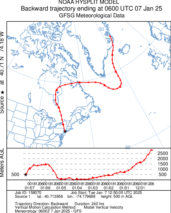
Today's air mass has origins in eastern Greenland.
-
A significant snowstorm continues to bring light snow to parts of the Middle Atlantic region. Snowfall amounts so far, include: Baltimore: 5.8" Bridgeport: 0.4" Islip: 0.4" New York City: 0.9" Newark: 0.8" Philadelphia: 1.8" Richmond: 4.0" Washington, DC: 5.5" An extended period of generally below normal temperatures is underway in the New York City area. Although this cold regime will likely extend through at least mid-month, the kind of severe cold that produces minimum temperatures below 10° in the Philadelphia to New York City areas is unlikely during that period. The cold could still peak with readings dropping into the teens and several subfreezing highs. The second and third weeks of January will likely feature widespread cold anomalies in much of the eastern half of the CONUS and Canada south of the Hudson and James Bays. The potential exists for widespread cold anomalies of 6°-10° below normal during that week in parts of that region, particularly the Southeast. Those anomalies will likely result more from the prolonged nature of the cold than its severity. However, notable exceptions could be areas with fresh snow cover that experience strong radiational cooling. The ENSO Region 1+2 anomaly was +0.1°C and the Region 3.4 anomaly was -0.7°C for the week centered around January 1. For the past six weeks, the ENSO Region 1+2 anomaly has averaged +0.02°C and the ENSO Region 3.4 anomaly has averaged -0.63°C. Neutral ENSO conditions may still evolve into a La Niña event during the winter. Uncertainty as to whether a La Niña will actually develop persists. On the December 19 outlook, 56% of dynamical models but 0% of the statistical models forecast the development of a La Niña. The SOI was +5.33 today. The preliminary Arctic Oscillation (AO) was -3.752 today.
-
Snowfall NYC subforum Jan 6 and OBS if needed
donsutherland1 replied to wdrag's topic in New York City Metro
Final snowfall amounts: BDR: 0.4" EWR: 0.8" ISP: 0.4" JFK: 0.5" LGA: 0.5" NYC: 0.9" -
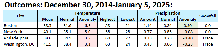
Weekly Outcome: It was somewhat warmer than had been modeled.

-
Snowfall NYC subforum Jan 6 and OBS if needed
donsutherland1 replied to wdrag's topic in New York City Metro
Flurries in the Bronx. -
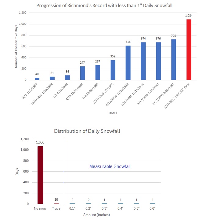
With 4.0” snowfall yesterday, Richmond’s dreadful 1,084-day string without 1” or more daily snowfall finally ended.