donsutherland1
-
Posts
24,197 -
Joined
Content Type
Profiles
Blogs
Forums
American Weather
Media Demo
Store
Gallery
Everything posted by donsutherland1
-
Occasional Thoughts on Climate Change
donsutherland1 replied to donsutherland1's topic in Climate Change
The persistence of the warmth has been remarkable. January 1-13, 2025 is running just over 0.1°C above January 2024 for the same timeframe on ERA-5. -
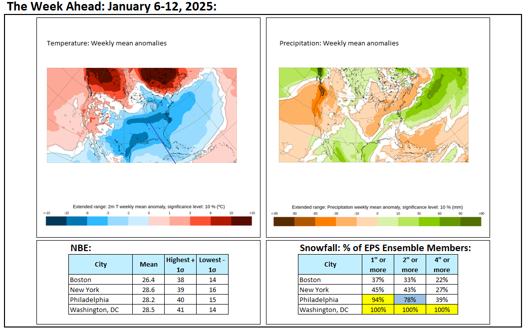
A colder air mass has returned to the region. Temperatures will generally average below normal across the region through Thursday or Friday before it turns briefly milder. Highs will mainly be in the lower 30s and lows will mainly be in the lower 20s in New York City and Philadelphia and teens outside the Cities through Thursday. An extended period of generally below normal temperatures is underway in the New York City area. The cold regime will likely last into at least the fourth week of January. The third week of January could see the month's first genuine Arctic outbreak around the the January 20-23 period. Moreover, there is a chance that New York City could experience temperatures falling into the low teens or even the single digits for lows. Moderation is possible during the closing days of January. There is potential for some snow to accompany the arrival of the Arctic air and perhaps afterward. However, with the AO forecast to become predominantly positive with the exception of a window during the January 18-24 period, prospects of a 6" or above snowstorm in the New York City and Philadelphia areas could be limited. The ENSO Region 1+2 anomaly was +0.3°C and the Region 3.4 anomaly was -0.7°C for the week centered around January 8. For the past six weeks, the ENSO Region 1+2 anomaly has averaged -0.02°C and the ENSO Region 3.4 anomaly has averaged -0.70°C. La Niña conditions are underway and will likely persist into the start of spring. The SOI was -18.41 today. The preliminary Arctic Oscillation (AO) was +1.483 today. Based on sensitivity analysis applied to the latest guidance, there is an implied 89% probability that New York City will have a colder than normal January (1991-2020 normal). January will likely finish with a mean temperature near 30.2° (3.7° below normal).
-
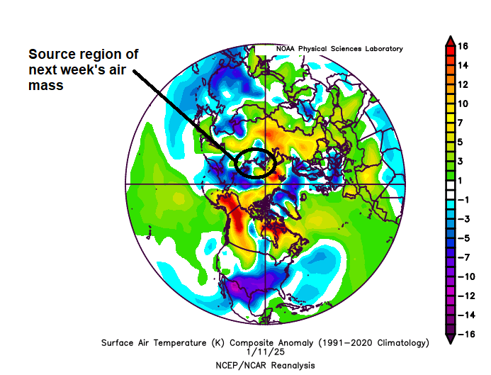
Next week will likely see temperatures bottom out in the lower teens or possibly even single digits in New York City as a genuine Arctic air mass overspreads the region. However, the cold air coming from near or off Russia is not exceptionally cold for the season, so that precludes the kind of strong Arctic outbreaks seen in 1985, 1994, and 2016.
-
For context, the Winter 2024-25 mean temperature (through January 13th) is 36.6° in New York City.
-
Unfortunately, a growing convergence of factors makes the kind of global cooperation that led to the Montreal Protocol to protect the ozone layer unlikely anytime soon when it comes to addressing fossil fuel burning. I don't see that changing for at least this decade, as the factors underpinning the status quo are likely too strong to overcome.
-
The aerosols were progressively reduced due to their health impact. It was only later that scientists concluded that aerosols had driven the post-1950 cooling. Aerosol injections could well have unintended adverse consequences. I still believe the better route is to address the root cause of the issue, namely the burning of fossil fuels. But, we'll see where things are in the 2030s.
-
The Earth was also gradually cooling, as it turned out from rising aerosols that were gradually reducing the amount of energy from the sun reaching the Earth. There were extensive deep pools of cold and sufficient blocking to lock in the cold in the Northeast.
-
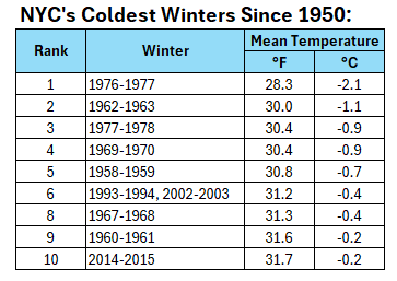
Here's a list of New York City's coldest winters since 1950:
-
A cold front will cross the region tonight or early tomorrow morning, possibly with some snow flurries. In its wake, temperatures will again be below normal through at least Friday. Highs will mainly be in the lower 30s and lows will mainly be in the lower 20s in New York City and Philadelphia and teens outside the Cities. An extended period of generally below normal temperatures is underway in the New York City area. The cold regime will likely last into at least the fourth week of January. The third week of January could see the month's first genuine Arctic outbreak around the the January 20-23 period. There is potential for some snow to accompany the arrival of the Arctic air. Moreover, there is a chance that New York City could experience temperatures falling into the low teens or even the single digits for lows. Moderation is possible during the closing days of January. There is potential for some snow to accompany the arrival of the Arctic air. However, with the AO forecast to become predominantly positive with the exception of a window during the January 18-24 period, prospects of a 6" or above snowstorm in the New York City and Philadelphia areas could be limited. The ENSO Region 1+2 anomaly was +0.3°C and the Region 3.4 anomaly was -0.7°C for the week centered around January 8. For the past six weeks, the ENSO Region 1+2 anomaly has averaged -0.02°C and the ENSO Region 3.4 anomaly has averaged -0.70°C. La Niña conditions are underway and will likely persist into the start of spring. The SOI was -19.12 today. The preliminary Arctic Oscillation (AO) was +0.303 today. Based on sensitivity analysis applied to the latest guidance, there is an implied 88% probability that New York City will have a colder than normal January (1991-2020 normal). January will likely finish with a mean temperature near 30.3° (3.6° below normal).
-
° As the maps are already available, it's difficult to envision their disappearance. That shifts the focus to calling out misuse of the maps for lack of a better description. The lack of accountability--lack of verification of forecasts on social media, for example--may well open the door to an entrepreneurial opportunity for meteorologists who not only post forecasts, but also verify the outcomes. That may offer them a competitive edge over their rivals who don't verify forecasts. But verification requires a degree of work (but AI can facilitate setting up the charts and tables, even the programming involved so the added work would probably not be substantial) and willingness to accept good and occasionally bad results. My guess is that if verification were involved, the practice of posting extreme maps that lead to 20°+ errors over 8-day periods from 5+ weeks out (or excessive snowfall maps), would cease. Such enormous errors speak for themselves.
-
The 1989 storm also missed, but the 500 mb pattern for that storm was different.
-
I agree. The event on the 22nd kind of reminds me, at least right now, of the February 6-7, 1980 storm that dumped > 10" at Norfolk but very little up in the NYC area. Fortunately, that's still far out, so things can change. At least there is some storminess.
-
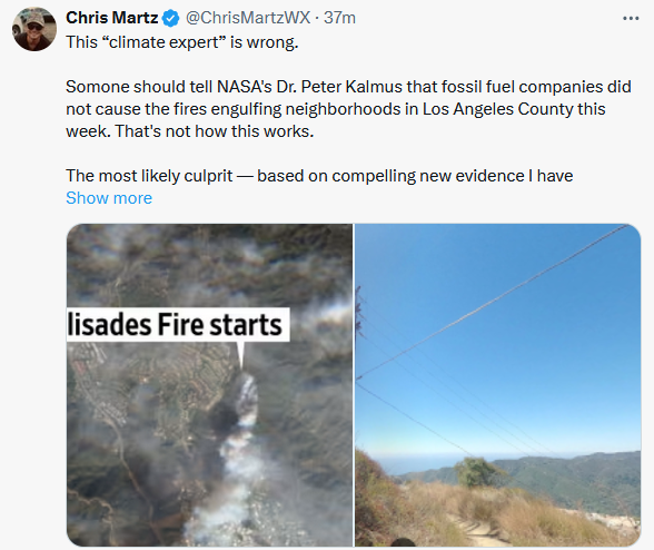
Apparently, the climate change denier who had no idea that drought products exist (and no idea southern California was in a drought), much less knowledge of flash droughts, has attacked Dr. Kalmus's op-ed. In doing so, he just further exposed that he is essentially illiterate on weather and climate. He has no conception that the fossil fuel burning leads to a warming climate, greater vapor pressure deficits, and increased frequency of drought/emergence of flash drought. All of those antecedent conditions ensure that any fires that start--be they from lightning or human-causes (accidental or otherwise)--will be more intense, more extensive, and more severe.
-
The final numbers:

-
Since December 1, 72% of days have seen a negative Arctic Oscillation (AO), including 47% during which it was -1.000 or below. The mean winter value to date is -0.871. As a result, both New York City and Philadelphia have seen their coldest start to winter since Winter 2017-2018. New York City has had a mean winter temperature of 36.5° (1.2° below normal) and Philadelphia has had a mean winter temperature of 36.5° (0.9° below normal). Tomorrow will be fair and pleasant. Temperatures will again top out in the upper 30s and lower 40s in New York City and Philadelphia. A cold front will then cross the region tomorrow night or early Tuesday morning, possibly with some snow flurries. In its wake, temperatures will again be below normal through at least Friday. An extended period of generally below normal temperatures is underway in the New York City area. The cold regime will likely last into at least the fourth week of January. The third week of January could see the month's first genuine Arctic outbreak around the the January 20-23 period. There is potential for some snow to accompany the arrival of the Arctic air. Moderation is possible during the days of January. The ENSO Region 1+2 anomaly was +0.1°C and the Region 3.4 anomaly was -0.7°C for the week centered around January 1. For the past six weeks, the ENSO Region 1+2 anomaly has averaged +0.02°C and the ENSO Region 3.4 anomaly has averaged -0.63°C. La Niña conditions are underway and will likely persist into the start of spring. The SOI was -20.82 today. The preliminary Arctic Oscillation (AO) was -1.367 today. Based on sensitivity analysis applied to the latest guidance, there is an implied 86% probability that New York City will have a colder than normal January (1991-2020 normal). January will likely finish with a mean temperature near 30.5° (3.4° below normal).
-
I stand corrected. They did.
-
With the 1/12 12z run of the ECMWF showing the possibility of another 1"+ snowfall in Atlanta (Days 9-10), it should be noted that the last winter that saw two 1" or more snowfalls in Atlanta was Winter 2017-18. For now, that's a reference point, and I have no comments on the actual amounts shown on what was an aggressive ECMWF output. We'll see how the pattern evolves.
-
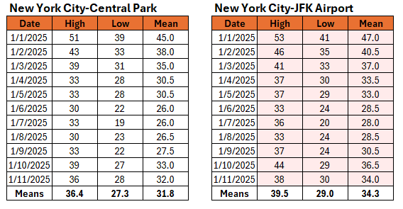
Through January 11th, every high and low at JFK has been above that at Central Park.
-
Perhaps, but the long-term trend still favors wetter years. There will be internal variability on a year-to-year basis. Drier cycles will probably be wetter than they were in the past, though stuck patterns such as what occurred in October may also increase in frequency. I suspect that the difficulty using it for forecasting purposes likely precluded much discussion. There is literature that goes back to the 1980s that I'm aware of. I suspect improvement in modeling resolution, better understanding of ocean-atmosphere dynamics (including second order effects), and AI/ML may add to forecasting skill over the next decade or so. But there may still be real limits on forecasting capacity beyond 15 days even then.
-
I suspect that there is a cyclical component. That's part of the reason I have been cautious in noting that it is possible, but not yet certain, that NYC is in the early stages of a decline in seasonal snowfall from warming . The recent low snowfall winters are probably a combination of the two, but more time is needed. By the mid-2030s, it should be clearer as winter temperatures reach thresholds where cities such as Washington saw a decline in seasonal snowfall. Having said that, there is added moisture from the warming atmosphere, hence the big snowstorms are even bigger (1996-2016 period) than they were in the past. Moreover, there will still be snowy winters and big snowstorms for at least decades to come.
-
The pressure dipole that comprises the EPO is a functon of atmosphere-ocean forcing (both ways). Unfortunately, the processes are complex and not well-understood leading to forecasting challenges beyond the short-term. ENSO has an impact, but there is a lot of random variability (likely due to factors that have not been identified and/or are not well-understood). Beyond 10-14 days, EPO forecasts lack skill. This is why the long-range EPS, which has shown a shift to positive values, keeps failing when the timeframe draws closer.
-
Yes, 1963-64 was an El Niño winter.
-
And before the blizzard, December 31 1963-January 1, 1964 saw snow in the Deep South. Atlanta picked up 2.2" and Birmingham saw 8.4".
-
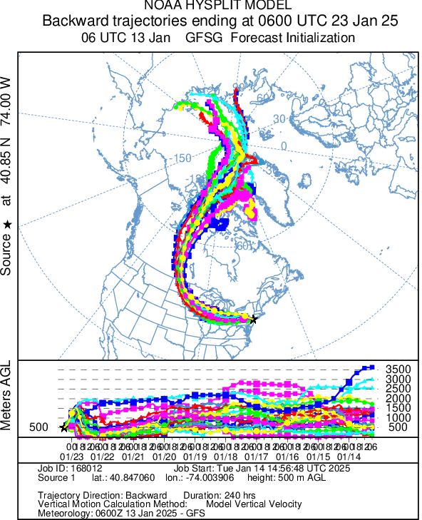
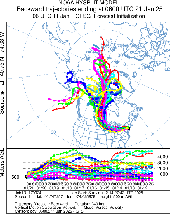
While the air mass that is likely to move into the Dakotas will likely be of Siberian origin, it is less clear whether the Siberian air will actually reach east of the Appalachians. Here's the latest Hysplit forecast for the NYC metro area:
-
The cold looks impressive, especially west of the Appalachians. Unlike the BAMWX 1/11-18 forecast for extreme cold, which will bust by > 20° for the forecast period, (both climo and a random number guess will easily beat its forecast), this cold shot looks to involve a genuine Arctic air mass. The previous cold has been largely from central and western Canada as per Hysplit. There are still some issues to work out about how could it gets in specific places (some disagreement between the prior 12z EPS and 0z EPS/GEFS vs. EPS). The sustained nature of the cold will lead to the eastern half seeing one of its colder Januaries in recent years. Unfortunately, anyone can throw up a social media account and claim to be a weather forecaster today. Based on the hype, it's clear that they don't understand what they are actually posting. For example, the BAM idea had Chicago with a mean temperature of -3° for the January 11-18 period. That's 1994 cold. Yet, had the site done minimal due diligence, it would have known that the cold would have been exceptional and it would also have seen that North America had been flooded with exceptionally frigid air well ahead of the Arctic outbreak that affected Chicago. This time around, there was much less frigid air on the maps. But it's easy to post models verbatim on social media, as the general public doesn't necessarily have the skill to discern junk from quality on the runs. No analysis was done, because analysis requires skill, knowledge, and expertise, which many of those sites lack. Indeed, the situation got so far out of hand that several NWS offices had to post advising the public to ignore maps being posted on social media. Finally, I'm not aware of a single such site that actually has weekly or monthly verifications. If they did, the results would be terrible. Not surprisingly, because of all the social media hype, the general public thinks meteorologists can't forecast (not actually true).