

donsutherland1
-
Posts
24,197 -
Joined
Content Type
Profiles
Blogs
Forums
American Weather
Media Demo
Store
Gallery
Everything posted by donsutherland1
-
I didn’t see any while I was there.
-
It will turn milder tomorrow. The thermometer could reach the upper 30s and perhaps 40°. The milder weather will likely continue through Tuesday before another cold front arrives possibly with some snow flurries or a brief period of light snow. Behind the front, it will turn noticeably colder. However, the cold won't be as sharp as it was earlier this week. In addition, with little or no precipitation expected through the remainder of January, several cities could approach or set records for their driest January on record. Precipitation amounts through January 25th and January Records: Islip: 0.37" (Record: 0.51", 1970) New York City-Central Park: 0.45" (Record: 0.58", 1981) New York City-LaGuardia Airport: 0.35" (Record: 0.51", 1981) Newark: 0.34" (Record: 0.45", 1981) Philadelphia: 0.39" (Record: 0.45", 1955) Poughkeepsie: 0.12" (Record: 0.43", 1970) White Plains: 0.18" (Record: 0.44", 1955) The AO is now positive and is expected to remain predominantly positive through at least the first week of February. As a result, prospects for a 6" or above snowstorm in the New York City area will be limited. Since 1950, just 2 of 19 (11%) of storms with an AO of +2.000 or above during January 15-February 15 saw 6" or more of snow in New York City. Opportunities for a 6" or above snowstorm could persist for parts of southern New England, including Boston, through January. The ENSO Region 1+2 anomaly was -0.1°C and the Region 3.4 anomaly was -0.6°C for the week centered around January 15. For the past six weeks, the ENSO Region 1+2 anomaly has averaged -0.07°C and the ENSO Region 3.4 anomaly has averaged -0.75°C. La Niña conditions are underway and will likely persist into the start of spring. The SOI was +9.33 yesterday. The preliminary Arctic Oscillation (AO) was +3.186 today. Based on sensitivity analysis applied to the latest guidance, there is an implied near 100% probability that New York City will have a colder than normal January (1991-2020 normal). January will likely finish with a mean temperature near 29.7° (4.2° below normal).
-
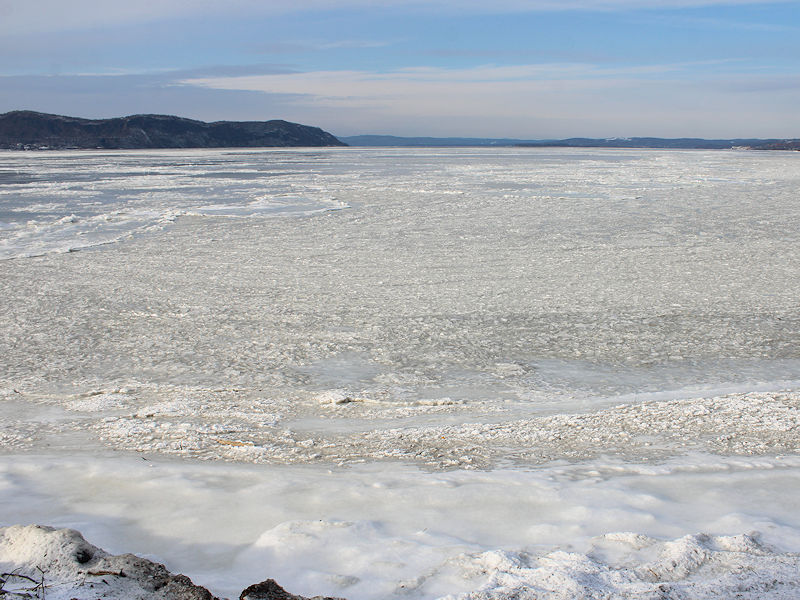
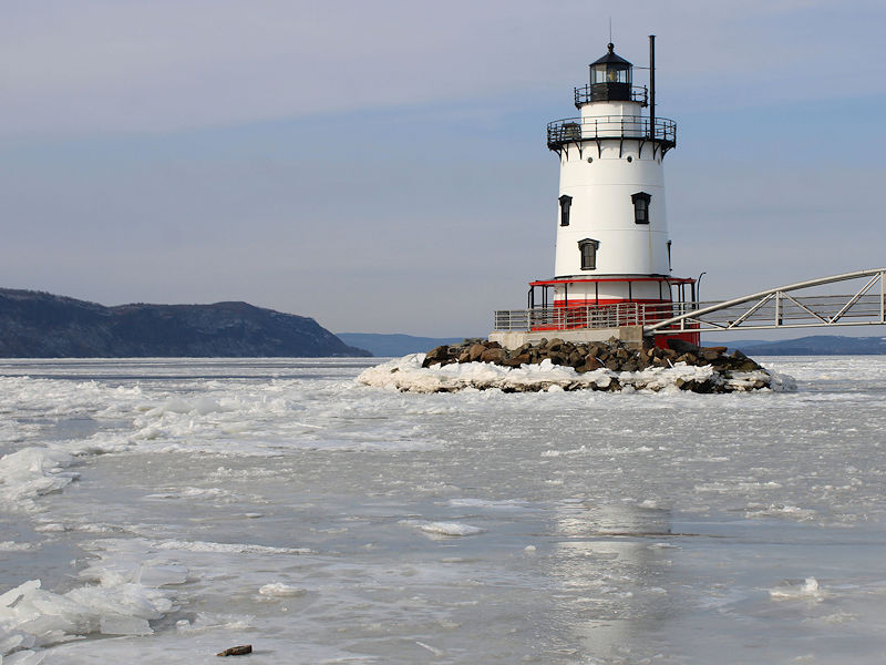
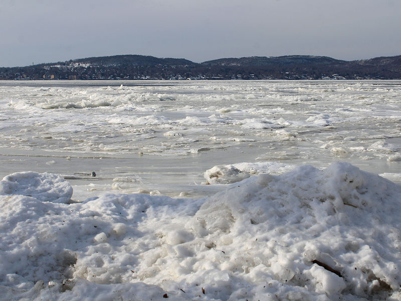
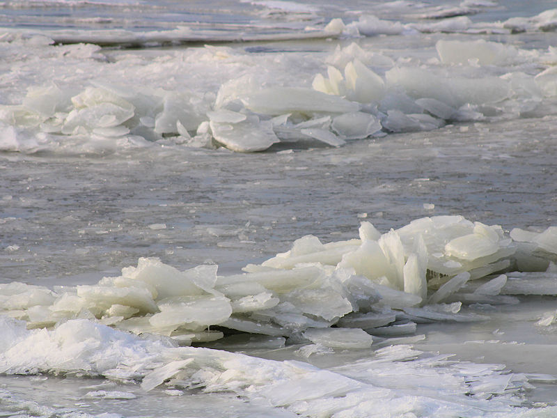
Five photos of the Hudson River from Kingsland Point Park in Sleepy Hollow, NY:
-
If we can keep getting at least pieces of cold air masses coming eastward after the first half of February, the PNA becomes less important due to the shortening of wave lengths. A number of the biggest storms during the second half of February have occurred with a PNA-. But let's see where we are as we near mid-February.
-
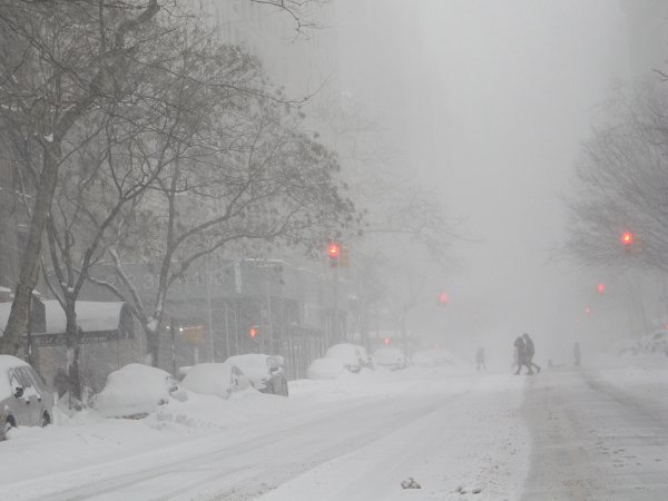
Photo from New York City:
-
I agree with you. From my having seen the changeover to snow/sleet on the observations, I expected a greater accumulation at Savannah. I hope that there will be some measure of quality control and, if appropriate, an adjustment. This was a historic storm and it would be a shame for a bad measurement to minimize what happened at Savannah.
-
A great piece on the New York Giants' historic blunder in letting Saquon Barkely leave. They should have re-signed him. Period. No excuses. The article highlights what happened: Barkley now stands as the utmost outlier in a league that compels teams to take hard stances on positional value to manage an inflexible salary cap. That’s why the Giants allowed him to flee to Philadelphia. They knew he was their most important weapon, but they couldn’t get past preconceived notions about the modern, textbook way to retool a deficient roster. Quite frankly, the Giants need structural changes at the top. As long as they remain constrained by yesterday's thinking, cognitive bias, and lack of imagination, they will sustain the kind of mediocrity that is difficult for Giants fans to bear. The article is here: https://wapo.st/4aEwTez
-
I don't expect a torch. It will be warmer than it has been but not exceptionally warm. Whether that changes during the second half of the month remains to be seen given the limits of model skill.
-
NYC got 8.1" from the first and 3.5" from the second.
-
The Gulf Coast snowstorm raced across the Atlantic, bombed out, and set wind records in Ireland. The cold is rapidly moderating. In the longer-range, the cold will increasingly dump into the West with pieces coming eastward. The cold shots in the East could be more transient in nature, unlike with this month. There is some uncertainty, as the weekly guidance is warmer than the closing days of the EPS and GEFS. I expect all of this guidance to converge in coming days. But the absence of blocking suggests a more transient nature to the cold shots.
-
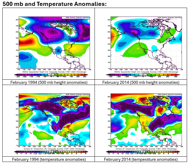
The EPS and EPS weeklies suggest that an AO+/PNA- pattern will prevail during most or all of the first half of February. Such a pattern comes with reduced prospects for 6" or more snow in the New York City area. Since 1950, 2 (13%) of 6" or greater snowstorms during February 1-15 occurred with an AO+/PNA-. New York City Dates: February 11-12, 1994 12.8" February 13-14, 2014 12.5" (changed to heavy rain before going back to snow) Both snowstorms had in common an unseasonably cold air mass as snow moved into the Middle Atlantic Region. In general, the pattern can provide ideas, but synoptic details (the presence of a deep cold air mass) matter. The 500 mb and temperature anomaly maps for both cases are below. Currently, the long-range guidance does not show 1994- or 2014-type cold across much of the East. That was the critical detail that overcame an otherwise hostile pattern. Unless that changes (or the forecast pattern changes), prospects for a significant or major snowfall in the New York City area during the first half of February will likely be limited.
-
1981 with 0.49". January 2025 has 0.50".
-
Some updates on last week’s thoughts: 1. Dry weather continued in southern California through the week. No rainfall was measured in Blythe, Camarillo, Lancaster, Los Angeles, and Palm Springs. 2. An East Coast snowstorm brought lighter amounts of snow to the I-95 area than had been modeled. Snowfall amounts included: Baltimore: 1.0”; Boston: 5.0”; New York City: 1.6”; Newark: 2.4”; Philadelphia: 2.0”; and Washington, DC: 0.3” 3. A severe cold shot affected the Great Lakes Region and East Coast from Sunday through Thursday. The lowest temperatures were: Baltimore: 6°; Boson: 10°; Chicago: -8° (two subzero lows); Detroit: -3°; Indianapolis: -3° (two subzero lows); New York City: 10°; Newark: 7° (two single-digit lows); Philadelphia: 10°; and, Washington, DC: 15° Both New York City and Philadelphia had high temperatures of 19° on January 21. Those were the coldest high temperatures there since December 24, 2022. 4. The Deep South was hit by a historic snowstorm on Tuesday into Wednesday. Snowfall amounts included: Atlanta: 1.1”; Baton Rouge: 7.6”; Charleston: 2.8”; Gulfport: 7.0”; Mobile: 7.5”; New Orleans: 8.0”; Pensacola: 8.9”; Savanah: 1.1”; Tallahassee: 0.1”. Milton (2 N), FL picked up 9.8” of snow. Prior to this storm, the greatest snowfall for Florida was 5.0” during January 9-10, 1800 (officially, the record was 4.0”). Record cold followed the heavy snowfall. Lafayette, LA, with a period of record that goes back to January 1893, set an all-time record low temperature of 4°. Four Thoughts Going Forward: 1. Some much needed rain will fall in southern California on Sunday through Tuesday. Los Angeles (LAX) could pick up an inch or more of rainfall. Blythe’s record streak without measurable rainfall will also end. Phoenix and Las Vegas will likely also see their second longest stretches without measurable precipitation end. 2. Parts of Texas, including Houston and Dallas could see significant rainfall, especially late in the week. 3. New York City and Philadelphia will likely see little or no precipitation through the end of January. One or both cities could finish with their driest January on record. The current records ae: New York City: 0.58”, 1981 and Philadelphia: 0.45”, 1955. 4. No significant snowstorms (6” or more) are likely in the Great Lakes and Middle Atlantic regions. Longer-Range: A slow moderation in temperatures is likely during the start of February. Above normal but not much above normal temperatures could develop in the eastern quarter of the United States after the first week of February. It could also turn wetter in the Great Lakes Region and parts of the eastern U.S. However, with the AO likely to be predominantly positive through at least the first week of February, the probability of a significant (6” or above) snowstorm in the New York City and Philadelphia areas will be limited.
-
No. It’s above its record.
-
The temperature topped out at 33° in New York City. Temperatures will top out near or just above 30° in New York City tomorrow. It will then turn milder on Sunday. The thermometer could reach the upper 30s on Sunday. The milder weather will likely continue through Tuesday before another cold front arrives possibly with some snow flurries or a brief period of light snow. Behind the front, it will turn noticeably colder. However, the cold won't be as sharp as it was earlier this week. In addition, with little or no precipitation expected through the remainder of January, several cities could approach or set records for their driest January on record. Precipitation amounts through January 24th and January Records: Islip: 0.37" (Record: 0.51", 1970) New York City-Central Park: 0.45" (Record: 0.58", 1981) New York City-LaGuardia Airport: 0.35" (Record: 0.51", 1981) Newark: 0.34" (Record: 0.45", 1981) Philadelphia: 0.39" (Record: 0.45", 1955) Poughkeepsie: 0.12" (Record: 0.43", 1970) White Plains: 0.18" (Record: 0.44", 1955) The AO is now positive and is expected to remain predominantly positive through at least the first week of February. As a result, prospects for a 6" or above snowstorm in the New York City area will be limited. Since 1950, just 2 of 19 (11%) of storms with an AO of +2.000 or above during January 15-February 15 saw 6" or more of snow in New York City. Opportunities for a 6" or above snowstorm could persist for parts of southern New England, including Boston, through January. A sustained milder period could develop during or after the first week of February. The ENSO Region 1+2 anomaly was -0.1°C and the Region 3.4 anomaly was -0.6°C for the week centered around January 15. For the past six weeks, the ENSO Region 1+2 anomaly has averaged -0.07°C and the ENSO Region 3.4 anomaly has averaged -0.75°C. La Niña conditions are underway and will likely persist into the start of spring. The SOI was +9.33 today. The preliminary Arctic Oscillation (AO) was +3.411 today. Based on sensitivity analysis applied to the latest guidance, there is an implied near 100% probability that New York City will have a colder than normal January (1991-2020 normal). January will likely finish with a mean temperature near 29.5° (4.4° below normal).
-
It's only about snowstorms, not annual records. Very few areas kept annual or monthly snowfall records prior to 1870.
-
No. It's strictly the 19th century.
-
I created a GPT based on my research into 19th century snowstorms in the Northeastern U.S. The link is: https://chatgpt.com/g/g-6793e4c7eac08191abc2b2b3be9be56d-19th-century-snowstorm-guide
-
Temperatures will mainly reach the upper 20s to near 30° in New York City through Saturday. It will then turn milder on Sunday. The thermometer could reach the upper 30s on Sunday. The milder weather will likely continue through Tuesday before another cold front arrives. The AO is now positive and is expected to remain predominantly positive into at least the middle of first week of February. As a result, prospects for a 6" or above snowstorm in the New York City area will be limited. Since 1950, just 2 of 19 (11%) of storms with an AO of +2.000 or above during January 15-February 15 saw 6" or more of snow in New York City. Opportunities for a 6" or above snowstorm could persist for parts of southern New England, including Boston, through January. A sustained milder period could develop during or after the first week of February. The ENSO Region 1+2 anomaly was -0.1°C and the Region 3.4 anomaly was -0.6°C for the week centered around January 15. For the past six weeks, the ENSO Region 1+2 anomaly has averaged -0.07°C and the ENSO Region 3.4 anomaly has averaged -0.75°C. La Niña conditions are underway and will likely persist into the start of spring. The SOI was +10.60 yesterday. The preliminary Arctic Oscillation (AO) was +2.963 today. Based on sensitivity analysis applied to the latest guidance, there is an implied near 100% probability that New York City will have a colder than normal January (1991-2020 normal). January will likely finish with a mean temperature near 29.6° (4.3° below normal).
-
The coldest 1977-present was -26 on January 11, 1988.
-
-15 and -20 respectively.
-
This is no surprise. They will seek to exploit every opportunity or small difference to push their disinformation. The fact is, they have been proved wrong when it comes to the bigger picture of climate change and its leading cause. They have no credible alternative explanations.
-
January 29, 1988: -21
-
I hope you feel better soon.
-
December 24, 1989: -20


