donsutherland1
-
Posts
24,197 -
Joined
Content Type
Profiles
Blogs
Forums
American Weather
Media Demo
Store
Gallery
Everything posted by donsutherland1
-
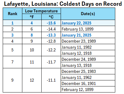
Yes. February 20, 1993 had the next colder reading (-18).
-
It was the coldest there since February 24, 2015 (-16).
-
The cold peaked this morning. Although New York City fell to 10° and Philadelphia bottomed out at 11°, temperatures outside both cities were much colder. Low temperatures included: Albany: -9° Allentown: -8° Binghamton: -5° Bridgeport: 7° Danbury: -7° Hartford: -6° Islip: 7° Montgomery: -14° Mount Pocono: -15° New Haven: 6° Newark: 8° Poughkeepsie: -10° Providence: 7° Reading: -7° Scranton: -9° Sussex: -14° Trenton: 2° Westhampton: 0° White Plains: 3° Very cold weather will prevail through tomorrow with temperatures slowly warming above freezing by Saturday and into the upper 30s by Sunday. The AO is now positive and is expected to remain predominantly positive into at least the middle of first week of February. As a result, prospects for a 6" or above snowstorm in the New York City area will be limited. Since 1950, just 2 of 19 (11%) of storms with an AO of +2.000 or above during January 15-February 15 saw 6" or more of snow in New York City. Opportunities for a 6" or above snowstorm could persist for parts of southern New England, including Boston, through January. A sustained milder period could develop during or after the first week of February. The ENSO Region 1+2 anomaly was -0.1°C and the Region 3.4 anomaly was -0.6°C for the week centered around January 15. For the past six weeks, the ENSO Region 1+2 anomaly has averaged -0.07°C and the ENSO Region 3.4 anomaly has averaged -0.75°C. La Niña conditions are underway and will likely persist into the start of spring. The SOI was +10.60 today. The preliminary Arctic Oscillation (AO) was +2.035 today. Based on sensitivity analysis applied to the latest guidance, there is an implied 99% probability that New York City will have a colder than normal January (1991-2020 normal). January will likely finish with a mean temperature near 29.7° (4.2° below normal).
-
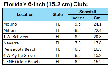
The 9.8" is listed as 2N Milton on the LSR.
-
1/21-1/22 Winter Storm OBS Thread
donsutherland1 replied to metalicwx367's topic in Southeastern States
-
In general, La Niña winters with less than 10" total snowfall through January haven't fared well during February or March. All winters since 1949-50: Mean February Snow: 8.9"; Mean March Snow: 4.5" All La Niña Winters/Less than 10" Snow through January 31: Mean February Snow: 4.2"; Mean March Snow: 3.7" All La Niña Winters/10" or More Snow through January 31: Mean February Snow: 9.2"; Mean March Snow: 4.7" With the February AO possibly averaging positive: All La Niña Winters: February AO > 0: Mean February Snow: 6.1"; Mean March Snow: 3.5" All La Niña Winters: February AO average of +0.5 or above: Mean February Snow: 4.1"; Mean March Snow: 1.3" Three out of five La Niña winters with a December PNA+ saw 10" or more snow in March. However, all three had 10" or more seasonal snowfall through January 31st. Sample sizes are small, so there is considerable sample size uncertainty.
-
1/21-1/22 Winter Storm OBS Thread
donsutherland1 replied to metalicwx367's topic in Southeastern States
Mesoscale Discussion 0053 NWS Storm Prediction Center Norman OK 0801 PM CST Tue Jan 21 2025 Areas affected...central and eastern portions of the Carolinas Concerning...Heavy snow Valid 220201Z - 220700Z SUMMARY...Moderate to heavy snow should gradually become widespread through early tonight across portions of the central and eastern Carolinas. DISCUSSION...700 mb warm-air and moisture advection are increasing over central and eastern parts of the Carolinas with the approach of a pronounced 500 mb trough that is traversing the central Appalachians. Beneath the 700 mb moistening, strong surface-850 mb cold-air advection is contributing to further saturation and sensible cooling of the column to support a predominance of snow, which is currently being indicated by surface observations on a widespread basis. Ahead of the upper trough, 700 mb frontogenesis is intensifying, which should support increased snowfall rates. As such, in addition to the transition to snow, 0.5-1.0 inch/hour snowfall rates may develop over the next couple of hours, as also suggested by some of the latest high-resolution guidance runs. ..Squitieri.. 01/22/2025 ...Please see www.spc.noaa.gov for graphic product... ATTN...WFO...AKQ...MHX...RAH...ILM...CHS...CAE...GSP... LAT...LON 31968072 32388112 33088159 33798169 34438124 35427983 35787825 36017695 36227604 35877554 35337562 34927650 34557721 34057805 33607881 32857959 32288042 31968072 -
1/21-1/22 Winter Storm OBS Thread
donsutherland1 replied to metalicwx367's topic in Southeastern States
Savannah has switched to light snow. -
1/21-1/22 Winter Storm OBS Thread
donsutherland1 replied to metalicwx367's topic in Southeastern States
- 369 replies
-
- 12
-

-

-
1/21-1/22 Winter Storm OBS Thread
donsutherland1 replied to metalicwx367's topic in Southeastern States
- 369 replies
-
- 10
-
-

-
New York City and Philadelphia had high temperatures of 19° today. The last time both cities had highs in the teens were: New York City: December 24, 2022 (15°) Philadelphia: December 24, 2022 (18°)
-
No. I presume that it was as of 1 pm CST.
-
1/21-1/22 Winter Storm OBS Thread
donsutherland1 replied to metalicwx367's topic in Southeastern States
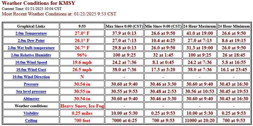
903 NOUS44 KLIX 212303 PNSLIX LAZ034>037-039-046>048-056>060-064>071-076>090-MSZ068>071-077-083>088-221103- Public Information Statement National Weather Service New Orleans LA 503 PM CST Tue Jan 21 2025 ...SNOWFALL REPORTS... Note- These are storm total snowfall amounts so please note the time they were taken. Snow amounts may vary within a parish due to the wind. Location Amount Time/Date Provider ...Louisiana... ...Ascension Parish... Geismar 8.1 in 0230 PM 01/21 Public 3 N Sorrento 7.0 in 0109 PM 01/21 Public Donaldsonville 7.0 in 0114 PM 01/21 CO-OP Observer Prairieville 7.0 in 0400 PM 01/21 Public 3 N Sorrento 6.0 in 0203 PM 01/21 Public 4 SSW Prairieville 6.0 in 0318 PM 01/21 Public 1 NNE Gonzales 5.8 in 0129 PM 01/21 Public ...Assumption Parish... 9 SW Labadieville 4.0 in 1238 PM 01/21 Public ...East Baton Rouge Parish... 3 SSW Baton Rouge 8.0 in 0258 PM 01/21 Public 2 SE Port Allen 7.0 in 1255 PM 01/21 Broadcast Media 2 SW Baton Rouge 7.0 in 0140 PM 01/21 Public 2 ESE Port Allen 6.5 in 0225 PM 01/21 Broadcast Media Baton Rouge 6.3 in 1122 AM 01/21 Public 1 SSE Westminster 6.0 in 0929 AM 01/21 Public 3 SSW Greenwell Spring 5.8 in 1203 PM 01/21 Baton Rouge 4.0 in 0920 AM 01/21 Public 2 SE Port Allen 3.5 in 0931 AM 01/21 Public 1 SSE Westminster 3.1 in 1049 AM 01/21 Public ...Jefferson Parish... Metairie 9.0 in 0439 PM 01/21 Public 1 NW Kenner 8.0 in 0500 PM 01/21 Official NWS Obs Kenner 5.5 in 1216 PM 01/21 Emergency Mngr 1 NW Gretna 5.0 in 0304 PM 01/21 Emergency Mngr 1 NE Kenner 4.0 in 1125 AM 01/21 Public ...Lafourche Parish... 7 NNE Thibodaux 6.0 in 0219 PM 01/21 Emergency Mngr Galliano 6.0 in 0405 PM 01/21 Public Thibodaux 5.0 in 0139 PM 01/21 Public ...Livingston Parish... 4 SW Killian 6.5 in 0405 PM 01/21 Public 1 N Denham Springs 6.0 in 1117 AM 01/21 Public 6 WNW Whitehall 5.0 in 1255 PM 01/21 Public 2 S Watson 4.0 in 1044 AM 01/21 Public Watson 4.0 in 1208 PM 01/21 Public ...Orleans Parish... 2 WSW New Orleans 9.8 in 0441 PM 01/21 Public 1 NW New Orleans 9.5 in 0345 PM 01/21 NWS Employee 1 SE New Orleans 8.0 in 0216 PM 01/21 Broadcast Media 2 NW Gretna 6.0 in 0227 PM 01/21 Public 2 ENE New Orleans 5.0 in 1121 AM 01/21 Public 2 WSW New Orleans 5.0 in 1257 PM 01/21 Public 2 WSW New Orleans 5.0 in 0111 PM 01/21 Trained Spotter 3 E New Orleans 4.0 in 1246 PM 01/21 Public ...St. Bernard Parish... 2 S Violet 7.0 in 0222 PM 01/21 Public ...St. Charles Parish... Norco 7.8 in 0201 PM 01/21 Public 1 ESE Hahnville 7.8 in 0400 PM 01/21 Emergency Mngr 3 ESE Destrehan 3.0 in 1014 AM 01/21 Public ...St. James Parish... 1 SSE Gramercy 7.0 in 0115 PM 01/21 Emergency Mngr 3 S Lutcher 6.5 in 0206 PM 01/21 Public ...St. John The Baptist Parish... 1 SSW Laplace 5.0 in 1253 PM 01/21 Public ...St. Tammany Parish... 3 ENE Slidell 6.8 in 0450 PM 01/21 Public 2 SE Pearl River 6.0 in 0430 PM 01/21 Public 2 E Mandeville 5.8 in 0407 PM 01/21 Public 4 E Mandeville 5.5 in 1218 PM 01/21 Public 2 N Lacombe 5.5 in 0430 PM 01/21 Public 2 ESE Mandeville 5.3 in 0500 PM 01/21 NWS Employee 2 N Mandeville 5.3 in 0500 PM 01/21 Public 3 NNE Slidell 5.1 in 0425 PM 01/21 NWS Employee 2 S Abita Springs 5.0 in 1136 AM 01/21 Public Pearl River 5.0 in 0111 PM 01/21 Public 6 ESE Robert 5.0 in 0159 PM 01/21 Public 3 S Covington 5.0 in 0318 PM 01/21 NWS Employee 5 NW Slidell 5.0 in 0400 PM 01/21 Official NWS Obs Covington 4.5 in 1124 AM 01/21 Public 7 ENE Robert 4.5 in 1251 PM 01/21 Public 6 E Robert 4.1 in 0109 PM 01/21 NWS Employee Pearl River 4.0 in 1104 AM 01/21 Public 5 SSE Bush 2.9 in 1100 AM 01/21 CO-OP Observer Slidell 2.8 in 0232 PM 01/21 NWS Employee Pearl River 2.0 in 1038 AM 01/21 Emergency Mngr ...Tangipahoa Parish... 2 N Springfield 6.5 in 0203 PM 01/21 Public Ponchatoula 6.0 in 0229 PM 01/21 Public Hammond 4.0 in 1134 AM 01/21 Public 1 N Hammond 4.0 in 1213 PM 01/21 Public ...Terrebonne Parish... 1 NW Houma 7.8 in 0228 PM 01/21 Public Gray 7.8 in 0403 PM 01/21 Public Schriever 7.5 in 0404 PM 01/21 Public 5 NNW Montegut 7.3 in 0404 PM 01/21 Public 2 NNW Bayou Cane 5.5 in 0139 PM 01/21 Public Houma 3.0 in 1000 AM 01/21 Public ...Washington Parish... 1 NE Bogalusa 4.0 in 1244 PM 01/21 Emergency Mngr ...West Baton Rouge Parish... 1 ESE Brusly 7.5 in 0223 PM 01/21 Public ...Mississippi... ...Hancock County... 1 ENE Waveland 6.0 in 0147 PM 01/21 Public Kiln 5.8 in 0400 PM 01/21 Public 1 N Kiln 5.5 in 0427 PM 01/21 Emergency Mngr 1 NNW Diamondhead 4.8 in 0228 PM 01/21 Public ...Harrison County... 6 NNW Saint Martin 8.3 in 0400 PM 01/21 Public 6 WNW Biloxi 5.0 in 0113 PM 01/21 Public 4 E Gulfport 4.0 in 1116 AM 01/21 Broadcast Media Pass Christian 3.0 in 1156 AM 01/21 Broadcast Media ...Jackson County... 3 ESE Gulf Park Estates 5.3 in 0127 PM 01/21 NWS Employee ...Pearl River County... 6 E Picayune 4.2 in 1110 AM 01/21 Public 2 N Picayune 3.1 in 1100 AM 01/21 Amateur Radio ...Pike County... Mccomb 2.8 in 0139 PM 01/21 Public ...Walthall County... 3 SSW Salem 5.0 in 0303 PM 01/21 Emergency Mngr Tylertown 1.9 in 0229 PM 01/21 Public && -
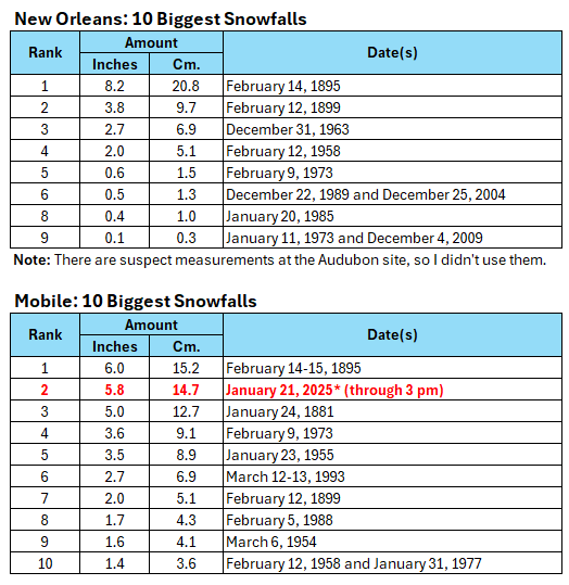
This morning, Newark had a low temperature of 7°. That was its first single-digit low temperature since February 4, 2023 when the mercury dipped to 5°. Very cold weather will prevail through Thursday. Temperatures could still fall into the single digits for lows in New York City and Philadelphia. The last single-digit lows were as follows: Baltimore: December 24, 2022 (6°) Boston: February 4, 2023 (-10°) New York City: February 4, 2023 (3°) Newark: January 21, 2025 (7°) Philadelphia: December 24, 2022 (7°) Washington, DC: December 24, 2022 (9°) A historic Gulf Coast snowstorm is underway. That storm will track well south and east of the region from tonight and tomorrow. Extreme southeast New Jersey and the Twin Forks of Long Island could see some flurries or perhaps some light snow. Already, Mobile (6.2") and Pensacola (5.0") have seen their biggest snowfall on record. Tallahassee could see its first snowfall since January 3, 2018 when 0.1" fell. The last storm that brought measurable snowfall to both New Orleans and Tallahassee occurred on February 9-10, 1973. The only storm to bring measurable snowfall to Houston, New Orleans, Gulfport, Mobile, Pensacola, and Tallahassee as is likely, was the legendary February 13-15, 1895 snowstorm. The AO has now gone positive. It is expected to remain predominantly positive into at least the first week of February. As a result, prospects for a 6" or above snowstorm will be limited. Since 1950, just 2 of 19 (11%) of storms with an AO of +2.000 or above during January 15-February 15 saw 6" or more of snow in New York City. Opportunities for a 6" or above snowstorm would likely persist for parts of southern New England, including Boston, through January. Moderation is likely during the opening of February. The ENSO Region 1+2 anomaly was -0.1°C and the Region 3.4 anomaly was -0.6°C for the week centered around January 15. For the past six weeks, the ENSO Region 1+2 anomaly has averaged -0.07°C and the ENSO Region 3.4 anomaly has averaged -0.75°C. La Niña conditions are underway and will likely persist into the start of spring. The SOI was +22.85 today. The preliminary Arctic Oscillation (AO) was +0.423 today. Based on sensitivity analysis applied to the latest guidance, there is an implied 99% probability that New York City will have a colder than normal January (1991-2020 normal). January will likely finish with a mean temperature near 29.4° (4.5° below normal).
-
1/21-1/22 Winter Storm OBS Thread
donsutherland1 replied to metalicwx367's topic in Southeastern States
There was a later report from Molino that was just under 7". The person doing the measuring is a trained spotter. -
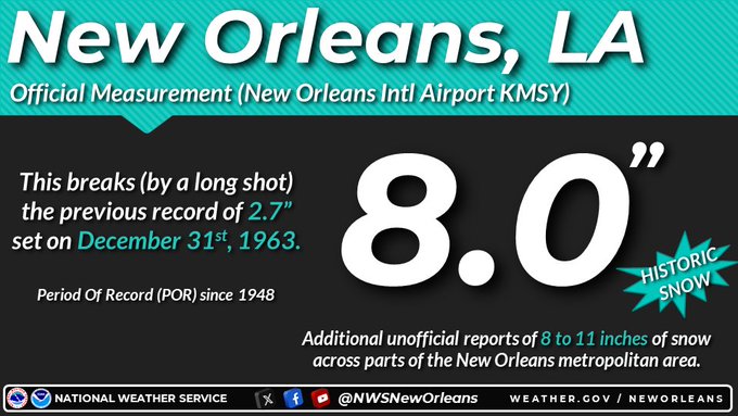
NWS reported 4.0" at the Airport. It hasn't commented yet on higher snowfall figures in and around the New Orleans area.
-
1/21-1/22 Winter Storm OBS Thread
donsutherland1 replied to metalicwx367's topic in Southeastern States
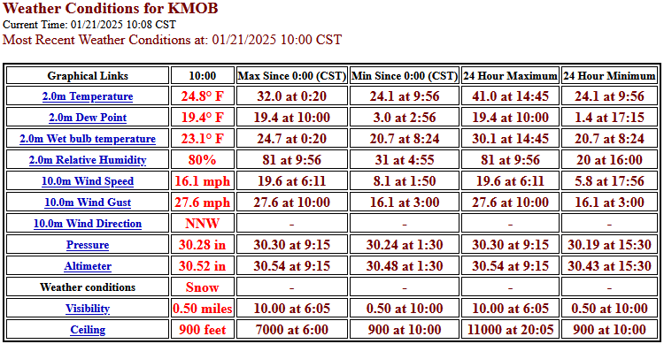
Mobile: 6.2" Pensacola: 5.0" Both are new storm total records. -
1/21-1/22 Winter Storm OBS Thread
donsutherland1 replied to metalicwx367's topic in Southeastern States
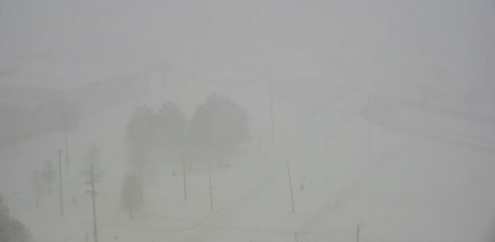
Pensacola: Less than 1/4-mile visibility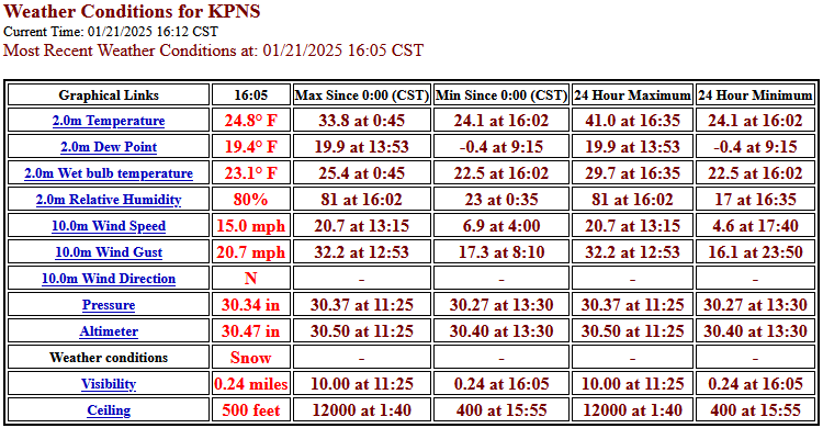
-
Unofficially, parts of the Panhandle are already there.
-
1/21-1/22 Winter Storm OBS Thread
donsutherland1 replied to metalicwx367's topic in Southeastern States
-
1/21-1/22 Winter Storm OBS Thread
donsutherland1 replied to metalicwx367's topic in Southeastern States
So far, Mobile has picked up 2.8" of snow today. That breaks the daily record of a trace that was set in 1979 and tied in 2022. Meanwhile, at Gulf Breeze, FL, the ground is now dusted by snow and sea smoke is rising from the Gulf of Mexico. Meanwhile, at New Orleans: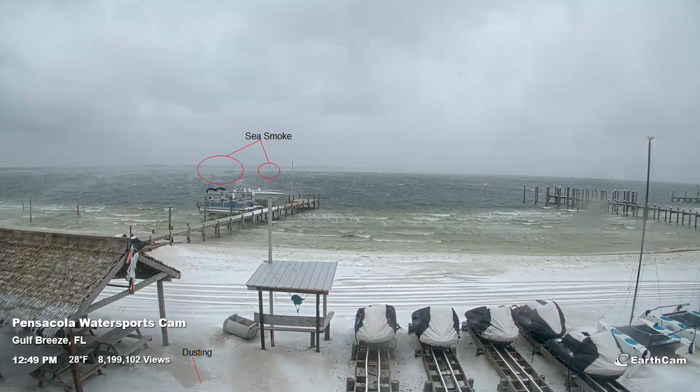
-
1/21-1/22 Winter Storm OBS Thread
donsutherland1 replied to metalicwx367's topic in Southeastern States
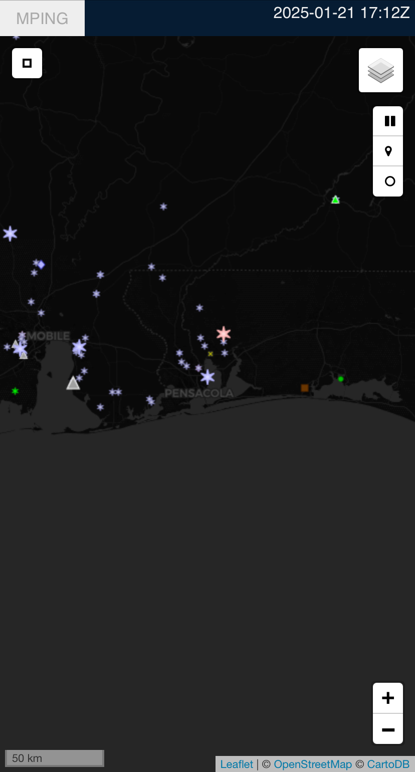
From mPING: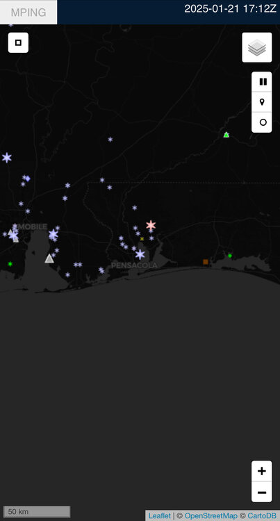
-
1/21-1/22 Winter Storm OBS Thread
donsutherland1 replied to metalicwx367's topic in Southeastern States
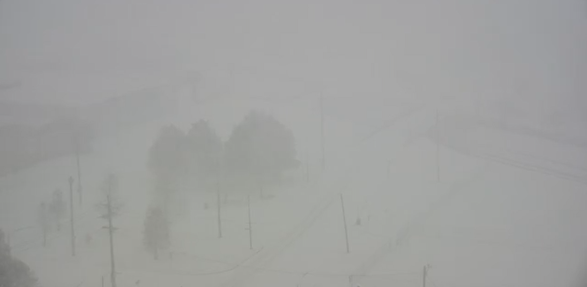
1/8 mile visibility -
It’s from Houston (3 SE). That’s not the official measurement.
-
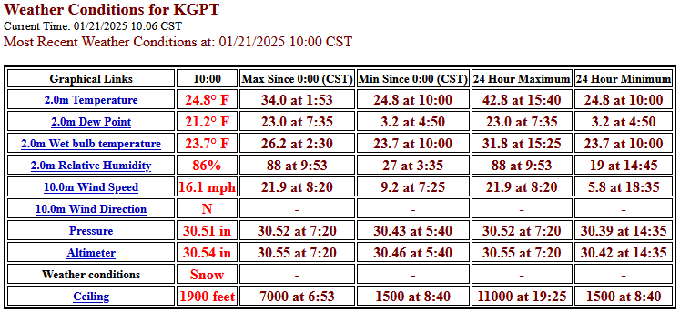
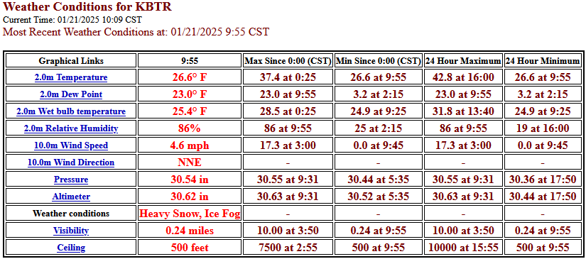
A snowstorm for the ages is blanketing the U.S. Gulf Coast. Some select observations: Baton Rouge: New Orleans: Webcam image from New Orleans: Gulfport: Mobile: