donsutherland1
-
Posts
24,197 -
Joined
Content Type
Profiles
Blogs
Forums
American Weather
Media Demo
Store
Gallery
Everything posted by donsutherland1
-
It still doesn't look like a disaster, but it will be warmer relative to normal than January has been. I reserve judgment about the second half of February, but can't rule out a break to a much warmer pattern for at least a time. The Great Lakes Region might have some opportunities to increase their seasonal snowfall amounts with a wetter pattern developing. Whether the storms cut will have a big impact farther east, especially for the Middle Atlantic region.
-
1/21-1/22 Winter Storm OBS Thread
donsutherland1 replied to metalicwx367's topic in Southeastern States
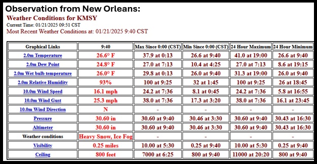
New Orleans webcams: https://wxyzwebcams.com/en/webcam-1023.php New Orleans Superdome: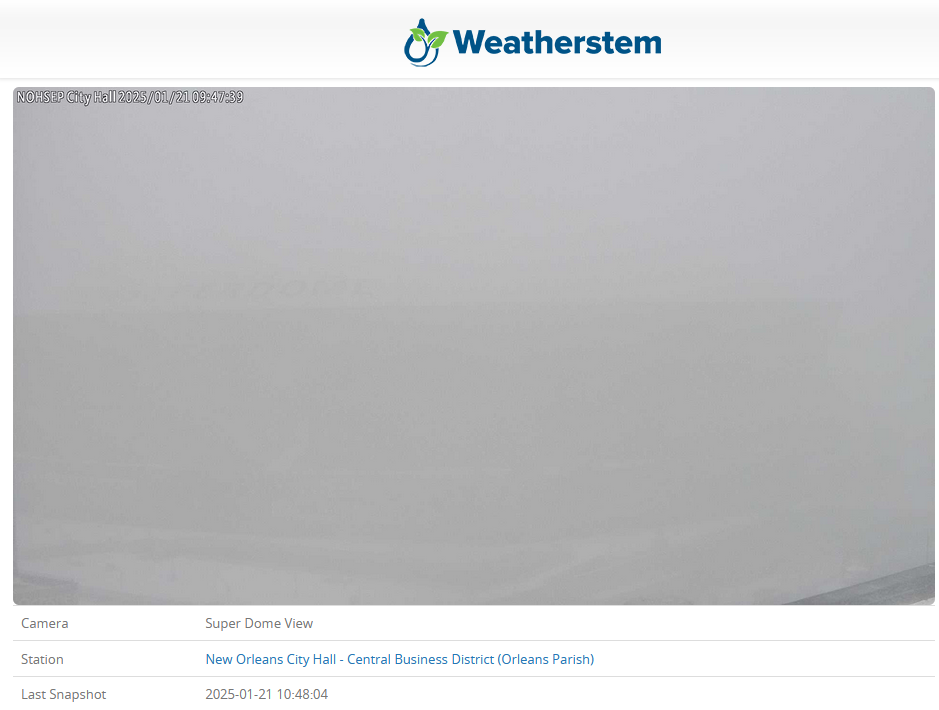
-
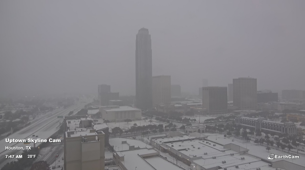
Houston (EarthCam):
-
Some 1" amounts through 6:50 am CST:
-
Yes, it's now beginning to show up prominently.
-
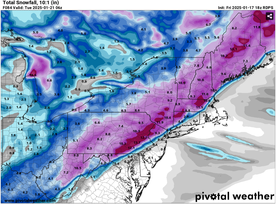
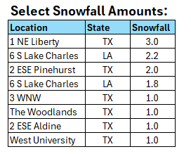
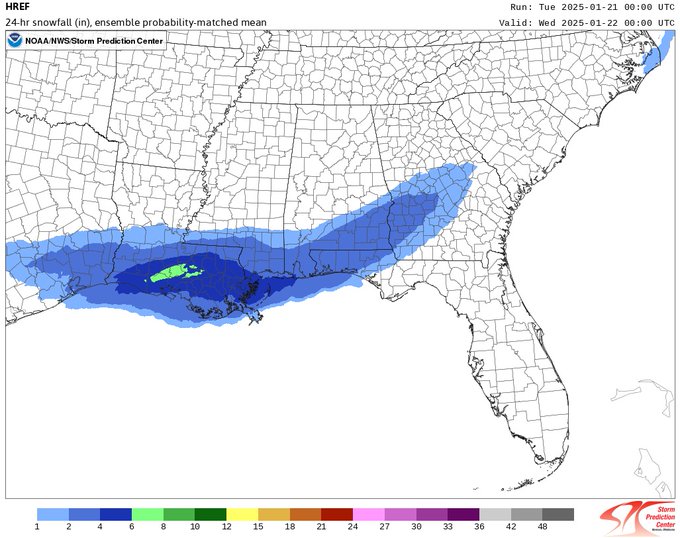
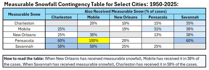
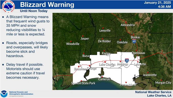
A historic Gulf Coast snowstorm is underway. Already, Houston has seen its first measurable snowfall since February 15, 2021 with 0.2" yesterday. The last storm that brought measurable snowfall to both New Orleans and Tallahassee occurred on February 9-10, 1973. The only storm to bring measurable snowfall to Houston, New Orleans, Gulfport, Mobile, Pensacola, and Tallahassee, as is likely with the ongoing storm, was the legendary February 13-15, 1895 snowstorm. Some snowfall amounts of 1" or above have already been measured. The 1/21 0z HREF: Parts of the region are even under an extremely rare blizzard warning: A contingency table for measurable snow events at select Gulf Coast cities:
-
This morning, Newark had a low temperature of 7°. That was its first single-digit low temperature since February 4, 2023 when the mercury dipped to 5°.
-
A potentially historic Gulf Coast snowstorm is getting underway. Light snow is now falling in New Orleans and a blizzard warning is in effect for parts of Louisiana. Below is a measurable snowfall contingency table for select cities.
-
Yes. 1899 was a rare event. Nothing like that is likely.
-
Philadelphia didn’t have any significant snowfalls.
-
Latest HREF:
-
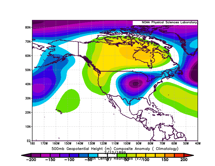
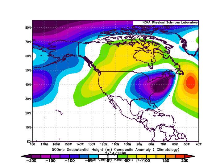
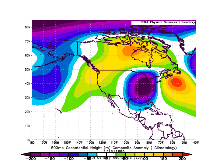
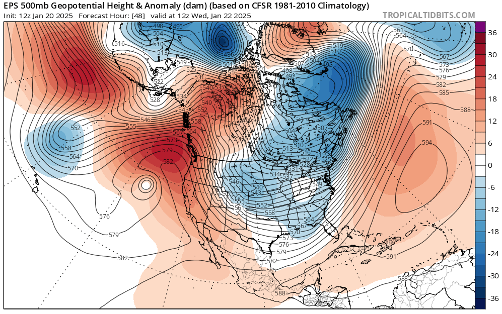
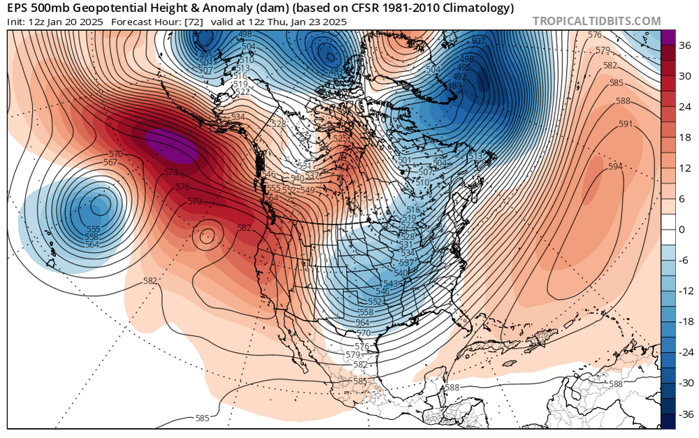
IMO, the region's best chance for flurries or light snow from the potentially historic Gulf Coast snowstorm will be southeastern NJ and easternmost Long Island. Perhaps the best case for New York City would be flurries or a dusting of snow, but that seems to be a low probability scenario right now. The storm in question has the potential to bring measurable snow to Gulfport, Houston, Mobile, New Orleans, Pensacola, and Tallahassee. Only the legendary February 13-15, 1895 snowstorm did that. That storm produced no measurable snow in New York City. If one widens the sample by selecting pairs of cities likely to receive measurable snowfall in the Gulf Coast/Southeast since 1950 and the New York City outcome, one finds: Savannah/Charleston received measurable snowfall: 0/6 storms brought measurable snowfall to NYC Mobile/Pensacola received measurable snowfall: 1/5 storms brought measurable snowfall to NYC (0.8") Mobile/Charleston received measurable snowfall: 0/4 storms brought measurable snowfall to NYC New Orleans/Mobile received measurable snowfall: 0/3 storms brought measurable snowfall to NYC New Orleans/Savannah received measurable snowfall: 0/3 storms brought measurable snowfall to NYC That's since 1950. The Blizzard of 1899 brought snow to the Gulf Coast and heavy snow to New York City. However, that blizzard was blocked from going out to sea by a strong ridge to its east that had rapidly strengthened coupled with an extraordinarily deep trough coming eastward. This time around, the trough is much less impressive and the offshore ridge is centered much farther to the east, essentially assuring that the storm does not have to turn northward up the coast. February 12, 1899: February 13, 1899: February 14, 1899: EPS: January 22 12z EPS:January 23 12z:
-
How the Pattern Verified: What I thought was plausible: - Measurable snowfalls: 2-4 days - 1" or more snowfall: 1-3 days - 2" or more snowfall: 1-2 days - 4" or more snowfall: 1 day Moderate snowfalls: 1 to perhaps 2 Significant snowfalls: Maybe 1 Outcome at Central Park: - Total snowfalls: 4 days - Measurable snowfalls: 3 days (January 6: 0.9"; January 11: 0.5"; January 19: 1.6"; Total: 3.0") - 1" or more: 1 day - 2" or more: None - 4" or more: None Outcome at JFK Airport: - Total snowfalls: 4 days - Measurable snowfalls: 3 days (January 6: 0.5"; January 11: 0.4"; January 19: 2.2"; Total: 3.1") - 1" or more: 1 day - 2" or more: 1 day - 4" or more: None Outcome at LaGuardia Airport: - Total snowfalls: 4 days - Measurable snowfalls: 3 days (January 6: 0.9"; January 11: 0.5"; January 19: 3.6"; Total: 5.0") - 1" or more: 1 day - 2" or more: 1 day - 4" or more: None Synoptic details can't be reliably forecast more than 5-7 days out. Those details are crucial and they made the difference in the outcome. Overall, the pattern produced in the larger Middle Atlantic and southern New England regions, just not in the New York City area (no moderate or significant snowfalls). Boston picked up 5.0" during January 19-20, 2025. Baltimore saw 6.6" on January 6, 2025 and Washington, DC received 7.2" on January 6, 2025. Richmond picked up 3.5" during January 5-6, 2025.
-
The January 19, 2025 snowstorm underperformed in the I-95 Corridor. However, snowfall amounts were still much higher than those suggested by the 1/17 18z RGEM for which "victory" had prematurely been declared. RGEM Amounts vs. Actual Amounts: Bridgeport: 0.7" (Actual: 2.3") Islip: 0.2" (Actual: 2.3") New York City: 0.5" (Actual: Central Park: 1.6"; JFK Airport: 2.2"; LaGuardia Airport: 3.6") Newark: 0.6" (Actual: 2.4") Philadelphia: 0.5" (Actual: 2.0")

-
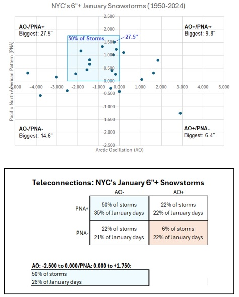
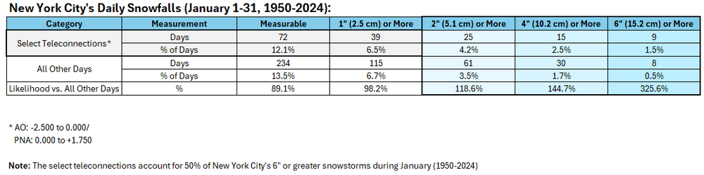
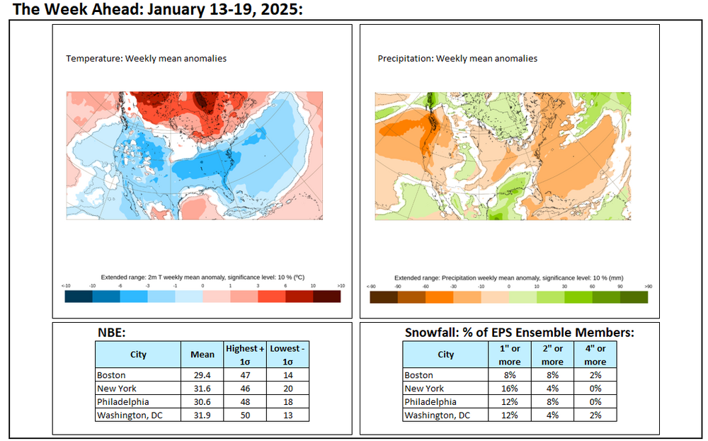
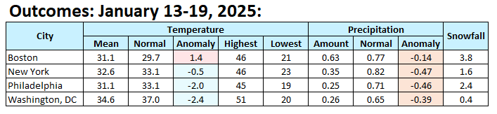
The storm that underperformed in much of the region has now departed and an unseasonably cold air mass is in place. Overall, the forecast was too aggressive. Final snowfall estimates and verification: Allentown: 4"-8" (Actual: 5.7") Baltimore: 2"-4" (Actual: 1.0") Boston: 4"-8" (Actual: 5.0") Islip: 2"-4" (Actual: 2.3") New York City: 3"-6" (Actual: 1.6") Newark: 3"-6" (Actual: 2.4") Philadelphia: 3"-6" (Actual: 2.0") Washington, DC: 1"-3" (Actual: 0.3") From tomorrow through Thursday, New York City will experience its coldest weather this winter. However, the air mass is not quite as cold as had previously been modeled. Temperatures could still fall into the single digits for lows in New York City and Philadelphia. The last single-digit lows were as follows: Baltimore: December 24, 2022 (6°) Boston: February 4, 2023 (-10°) New York City: February 4, 2023 (3°) Newark: February 4, 2023 (5°) Philadelphia: December 24, 2022 (7°) Washington, DC: December 24, 2022 (9°) Highs could reach no higher than the teens in New York City and perhaps Philadelphia during the peak of the cold. The last time both cities had high temperatures in the teens was: New York City: December 24, 2022 (15°) Philadelphia: December 24, 2022 (18°) There is a chance that New York City could see two consecutive highs in the teens for the first time since January 6-7, 2018 when the highs were 13° and 18° respectively. A storm will track well south and east of the region from tomorrow into Thursday. Extreme southeast New Jersey and the Twin Forks of Long Island could see some flurries or perhaps some light snow. That storm has the potential to bring measurable snowfall to Atlanta, Charleston, Norfolk, and Wilmington, NC. The last time that happened was during what became known as the Boxing Day Blizzard of December 25-27, 2010. Parts of the Southeast could see a significant snow, sleet, and ice event from this storm. Tallahassee could see its first snowfall since January 3, 2018 when 0.1" fell. New Orleans could see its first measurable snowfall since December 4, 2009. The last storm that brought measurable snowfall to both New Orleans and Tallahassee occurred on February 9-10, 1973. The AO went negative on Saturday. With the AO forecast to become predominantly positive after January 24th, prospects for a 6" or above snowstorm in the New York City and Philadelphia areas could become limited after January 24th. With the AO likely to spend time at or above +2.000 afterward into at least early February, odds of a 6" or above snowfall in New York City will be very low. Since 1950, just 2 of 19 (11%) of storms with an AO of +2.000 or above during January 15-February 15 saw 6" or more of snow. Opportunities for a 6" or above snowstorm would likely persist for parts of southern New England, including Boston, through January. Moderation is likely during the opening of February. The ENSO Region 1+2 anomaly was +0.3°C and the Region 3.4 anomaly was -0.7°C for the week centered around January 8. For the past six weeks, the ENSO Region 1+2 anomaly has averaged -0.02°C and the ENSO Region 3.4 anomaly has averaged -0.70°C. La Niña conditions are underway and will likely persist into the start of spring. The SOI was +18.61 today. The preliminary Arctic Oscillation (AO) was -0.545 today. Based on sensitivity analysis applied to the latest guidance, there is an implied 99% probability that New York City will have a colder than normal January (1991-2020 normal). January will likely finish with a mean temperature near 29.4° (4.5° below normal).
-
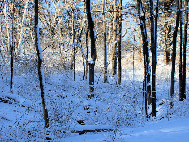
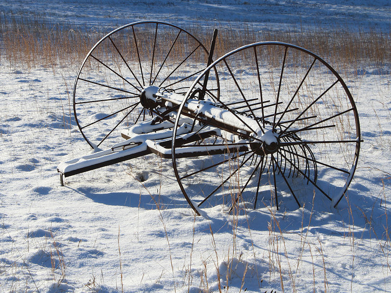
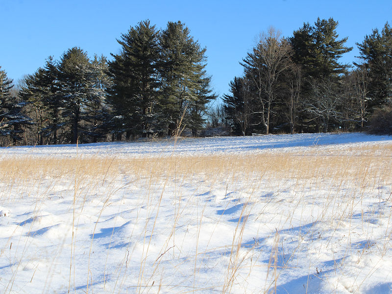
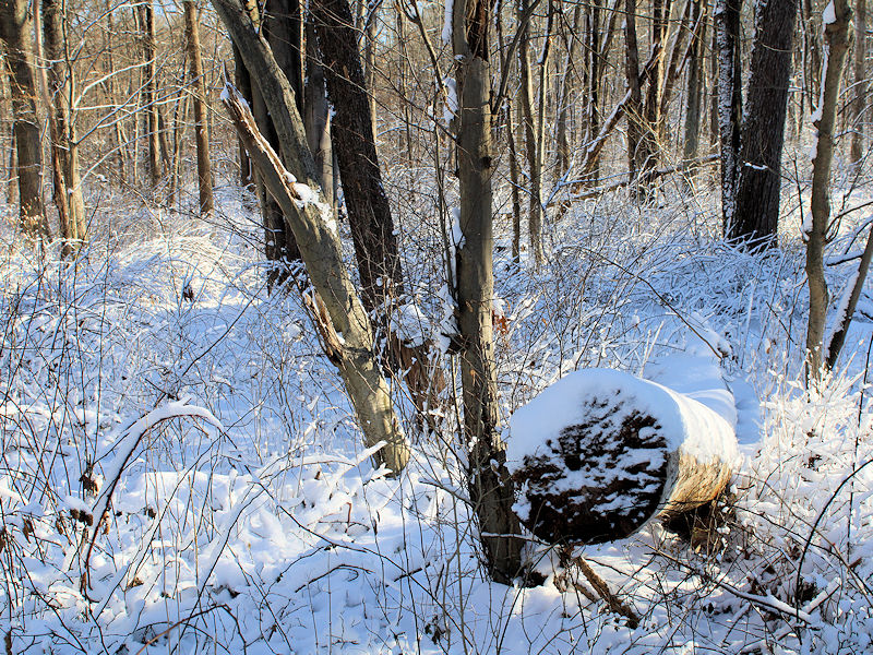
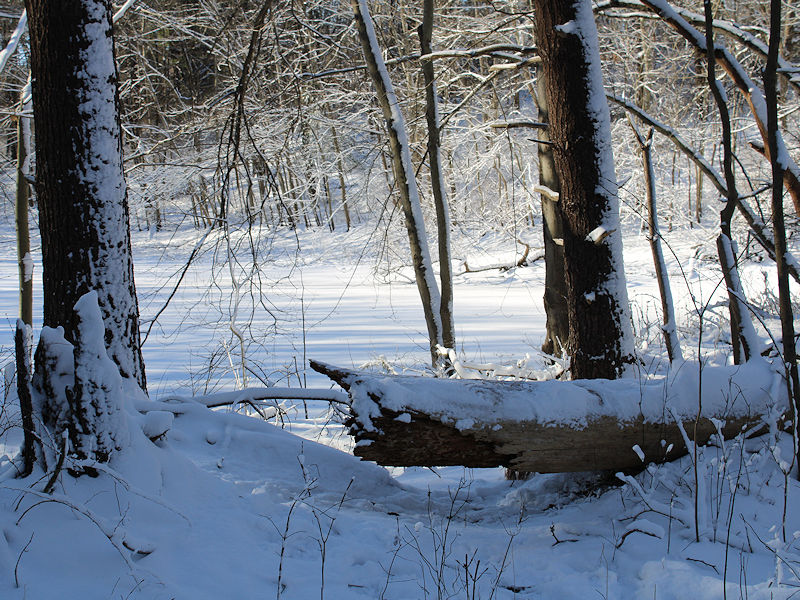
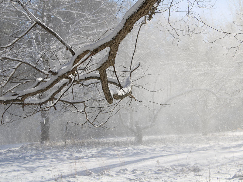
Photos from the snowstorm taken at Nichols Preserve (Greenwich, CT) where about 4" of powdery snow fell.
-
Yes. I agree with you.
-
Yes. My forecast was too high.
-
The cutoff date for the number was through Sunday. Some of the snow will also be recorded with next week's update. Either way, the EPS missed the timing and likelihood of the snow from a week out.
-
The final outcome: It should be noted that Boston received a storm total 5.0" snowfall.
-
NOUS41 KOKX 200627 PNSOKX CTZ005>012-NJZ002-004-006-103>108-NYZ067>075-078>081-176>179-201827- Public Information Statement National Weather Service New York NY 127 AM EST Mon Jan 20 2025 ...SNOWFALL REPORTS... Location Amount Time/Date Provider ...Connecticut... ...Fairfield County... New Fairfield 5.2 in 1015 PM 01/19 Trained Spotter Danbury 4.3 in 0900 PM 01/19 Trained Spotter Ridgefield 3.8 in 0915 PM 01/19 Cocorahs Weston 3.8 in 1030 PM 01/19 Trained Spotter Easton 3.3 in 1000 PM 01/19 Public 3 NE Southport 3.0 in 0918 PM 01/19 Public Bridgeport Airport 2.3 in 1140 PM 01/19 Official NWS Obs Greenwich 2.3 in 1000 PM 01/19 Public Norwalk 2.3 in 0900 PM 01/19 Public Fairfield 2.0 in 0813 PM 01/19 Public Stamford 2.0 in 1058 PM 01/19 Public Newtown 1.5 in 0700 PM 01/19 Trained Spotter ...Middlesex County... Durham 2.0 in 1000 PM 01/19 Amateur Radio Chester 1.5 in 1000 PM 01/19 Amateur Radio ...New Haven County... North Haven 4.0 in 0100 AM 01/20 Trained Spotter Wallingford 3.0 in 1000 PM 01/19 Amateur Radio Milford 2.5 in 1000 PM 01/19 Amateur Radio Hamden 2.0 in 1000 PM 01/19 Amateur Radio Meriden 2.0 in 1006 PM 01/19 Amateur Radio Branford 1.2 in 1155 PM 01/19 Public ...New Jersey... ...Bergen County... Franklin Lakes 5.9 in 1000 PM 01/19 Trained Spotter Waldwick 5.6 in 1049 PM 01/19 Public Westwood 5.2 in 0922 PM 01/19 Trained Spotter Fair Lawn 5.0 in 1100 PM 01/19 Cocorahs River Vale 5.0 in 0945 PM 01/19 Trained Spotter Bergenfield 4.8 in 1003 PM 01/19 Trained Spotter Ramsey 4.5 in 0600 PM 01/19 Public East Rutherford 3.3 in 1020 PM 01/19 Trained Spotter River Edge 3.2 in 1000 PM 01/19 Public ...Essex County... Caldwell 5.0 in 0955 PM 01/19 Public West Orange 4.5 in 0101 AM 01/20 Public Livingston 4.4 in 1034 PM 01/19 Public Nutley 4.0 in 1000 PM 01/19 Public ...Hudson County... West New York 3.1 in 1115 PM 01/19 Public Harrison 3.0 in 0900 PM 01/19 CO-OP Observer Hoboken 3.0 in 1000 PM 01/19 Trained Spotter Kearny 3.0 in 1013 PM 01/19 Trained Spotter Jersey City 2.5 in 0840 PM 01/19 Public ...Passaic County... Ringwood 6.3 in 0840 PM 01/19 Public Pompton Lakes 5.6 in 1000 PM 01/19 Trained Spotter 3 NE Wanaque 5.0 in 0646 PM 01/19 Cocorahs Totowa 5.0 in 1019 PM 01/19 Public Passaic 4.8 in 1005 PM 01/19 Public 1 ESE Ringwood 4.7 in 0633 PM 01/19 Public ...Union County... Berkeley Heights 4.5 in 1040 PM 01/19 Public Mountainside 4.5 in 1000 PM 01/19 Public Elizabeth 3.7 in 0900 PM 01/19 Trained Spotter Cranford 3.5 in 1027 PM 01/19 Trained Spotter Plainfield 3.5 in 1000 PM 01/19 Trained Spotter Newark Airport 2.4 in 1200 AM 01/20 Official NWS Obs ...New York... ...Kings County... Bedford-Stuyvesant 3.0 in 0900 PM 01/19 Public 1 NNE Sheepshead Bay 3.0 in 1030 PM 01/19 Public Midwood 2.7 in 1222 AM 01/20 Broadcast Media Sheepshead Bay 2.5 in 1100 PM 01/19 Trained Spotter ...Nassau County... 2 ENE Roosevelt 4.1 in 1018 PM 01/19 Public Syosset 4.0 in 1000 PM 01/19 Trained Spotter East Williston 3.9 in 1015 PM 01/19 Public 1 ESE East Meadow 3.8 in 1117 PM 01/19 Trained Spotter Sea Cliff 3.6 in 1042 PM 01/19 Public Massapequa 3.2 in 1000 PM 01/19 Public Farmingdale 3.0 in 1030 PM 01/19 Public Plainview 3.0 in 1028 PM 01/19 Public Manhasset Hills 2.6 in 1227 AM 01/20 Cocorahs 1 E East Meadow 2.5 in 1038 PM 01/19 NWS Employee Levittown 2.5 in 0930 PM 01/19 Trained Spotter East Meadow 2.1 in 0950 PM 01/19 NWS Employee 1 NE Roosevelt 2.0 in 1030 PM 01/19 Broadcast Media 2 SSE Plainedge 2.0 in 0814 PM 01/19 Public East Rockaway 1.8 in 0935 PM 01/19 Public Elmont 1.0 in 0712 PM 01/19 Public ...New York (Manhattan) County... 1 SSE Midtown Manhattan 1.8 in 0950 PM 01/19 Public Central Park 1.6 in 1200 AM 01/20 Official NWS Obs ...Orange County... Highland Mills 8.1 in 1100 PM 01/19 Public Chester 7.7 in 0834 PM 01/19 Public Middletown 7.0 in 0920 PM 01/19 Fire Dept/Rescue Monroe 7.0 in 0925 PM 01/19 Trained Spotter New Windsor 7.0 in 1054 PM 01/19 Trained Spotter Salisbury Mills 7.0 in 0900 PM 01/19 Trained Spotter Cornwall on Hudson 6.8 in 1000 PM 01/19 Cocorahs Pine Bush 6.7 in 1103 PM 01/19 Public 2 S Montgomery Airport 5.5 in 0815 PM 01/19 Public 5 E Port Jervis 5.0 in 0700 PM 01/19 Public Washingtonville 4.8 in 0749 PM 01/19 Public ...Putnam County... 3 WNW Fahnestock State Park 6.5 in 0930 PM 01/19 Trained Spotter Putnam Valley 5.6 in 1050 PM 01/19 Newspaper ...Queens County... NYC/La Guardia 3.6 in 1200 AM 01/20 Official NWS Obs Howard Beach 3.5 in 1100 PM 01/19 Public 1 SE Fresh Meadows 2.7 in 1135 PM 01/19 Public 2 WSW Bellerose 2.3 in 0900 PM 01/19 Public NYC/JFK 2.2 in 1200 AM 01/20 Official NWS Obs Little Neck 2.0 in 1030 PM 01/19 Trained Spotter ...Richmond County... 1 E New Dorp 3.5 in 1000 PM 01/19 Public Westerleigh 2.6 in 0950 PM 01/19 Public ...Rockland County... Congers 6.5 in 1000 PM 01/19 Fire Dept/Rescue Monsey 5.2 in 1055 PM 01/19 Trained Spotter New City 5.0 in 1000 PM 01/19 Trained Spotter Nyack 1.8 in 0700 PM 01/19 Public Chestnut Ridge 1.2 in 0450 PM 01/19 Public ...Suffolk County... Commack 3.5 in 1000 PM 01/19 Public Babylon 3.3 in 0951 PM 01/19 Public Port Jefferson 3.3 in 1020 PM 01/19 Trained Spotter Centereach 3.2 in 1040 PM 01/19 NWS Employee Stony Brook 3.0 in 1030 PM 01/19 NWS Employee Mount Sinai 2.8 in 1000 PM 01/19 Trained Spotter Islip 2.3 in 1145 PM 01/19 Official NWS Obs Deer Park 1.9 in 0825 PM 01/19 Amateur Radio Upton 1.9 in 0930 PM 01/19 Official NWS Obs Huntington Station 1.8 in 1000 PM 01/19 NWS Employee Bellport 1.5 in 0945 PM 01/19 Trained Spotter Hampton Bays 1.5 in 1109 PM 01/19 Public North Patchogue 1.5 in 1235 AM 01/20 Public 1 SE Ridge 1.5 in 1200 AM 01/20 Public East Islip 1.1 in 0820 PM 01/19 Amateur Radio ...Westchester County... Croton-on-Hudson 5.5 in 0914 PM 01/19 Public Ossining 5.5 in 1000 PM 01/19 Public Valhalla 4.5 in 1100 PM 01/19 Public Yonkers 3.1 in 1205 AM 01/20 Trained Spotter Rye 2.0 in 1000 PM 01/19 Public Rye Brook 1.5 in 0723 PM 01/19 Amateur Radio &&
-
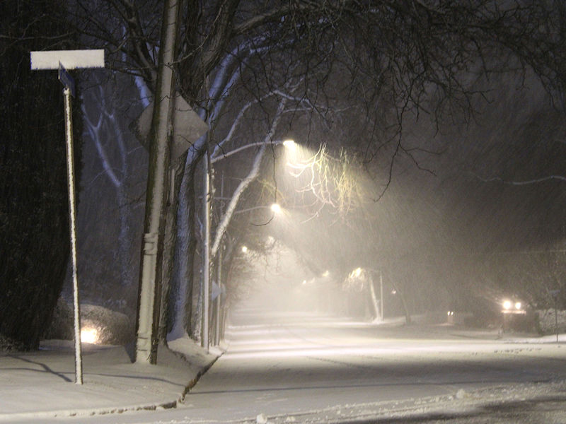
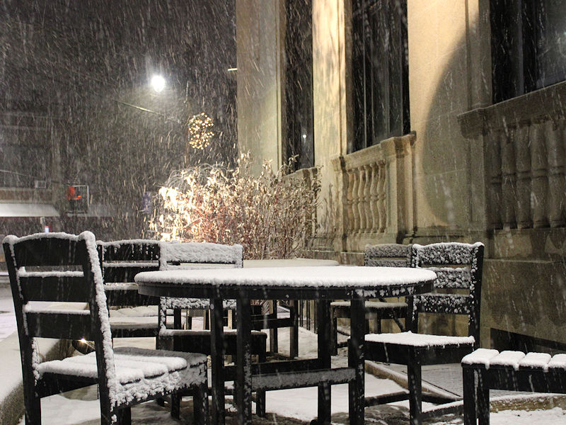
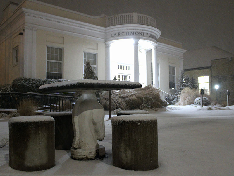
Three photos from this evening:
-
Mamaroneck, NY:
-
I'm happy to learn she's making a recovery. Let's hope all goes well and that she can go home, soon.
-
I'm sorry to hear of your sister-in-law's stroke. I wish her a full recovery.