donsutherland1
-
Posts
24,197 -
Joined
Content Type
Profiles
Blogs
Forums
American Weather
Media Demo
Store
Gallery
Everything posted by donsutherland1
-
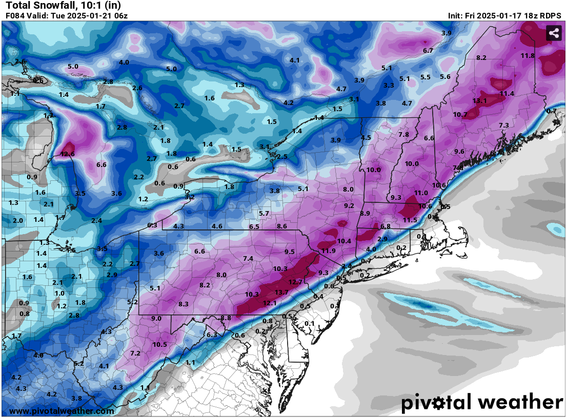
And the RGEM 24 hours later (1/18 18z): Key Points: 1. Don't prematurely verify model outcomes 2. Don't assume model outcomes are locked in stone 3. Consider whether the model solution makes sense given the larger pattern and the other guidance Verification will be provided following the storm


-
For reference:
-
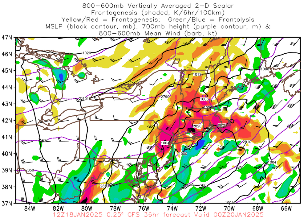
Another Social Media post to be added to the verification pile (BAMWX's call for historic cold will be verified tomorrow): The above post was made yesterday after the 1/18 0z HRRR came out and seemingly supported the 1/17 18z RGEM, which is posted below: Before one prematurely claims verification, possibly based on confirmation bias, one should examine the pattern to see if the particular guidance makes sense. The pattern has some similarities with that of the January 22, 1987 snowstorm, that brought 8.1" to New York City and 8.8" to Philadelphia. This time around, the ridging off the East Coast will be less impressive than it was in 1987 and the storm won't be as moisture-laden. Thus, snowfall amounts will be lower than they were in 1987. At the same time, a mostly rain scenario in New York City is unlikely. My thinking last evening, which incorporated my assessment of the pattern that I posted on this morning and considered all of the guidance: Snow will likely accompany the arrival of the Arctic air to the region. A developing storm will likely bring a general 3"-6" snowfall from Philadelphia to New York City with a stripe of 4"-8" amounts to the north and west of this region. 1"-3" amounts are likely east of Islip. The RGEM is a very good mesoscale model, but it appeared to be an outlier from a general consensus that existed among the guidance. Since then, it has corrected quite aggressively in its 1/18 6z and 12z runs moving into decent agreement with the model consensus.
-
Some updates on last week’s thoughts: 1. Dry weather continued in southern California through. Blythe, Camarillo, Lancaster, Los Angeles, and Palm Springs all saw no rainfall. 2. There was no significant (6”+) snowstorm in the big cities of the Middle Atlantic and southern New England regions (Richmond to Boston) during the upcoming week. The heaviest snowfall amounts for the week were as follows: Baltimore: Trace; Boston: Trace; New York City: Trace; Philadelphia: 0.4“; Richmond: None; and, Washington, DC: 0.1”. 3. A strong cold shot affected the Great Lakes Region Tuesday through Thursday. Indianapolis saw the temperature bottom out at -1°. Detroit saw two consecutive single-digit lows (coldest temperature: 8°). Chicago saw the temperature fall to 5° and three consecutive single-digit lows. Four Thoughts Going Forward: 1. Dry weather will continue in southern California through the week. Little or no rainfall is likely in such cities as Blythe, Camarillo, Lancaster, Los Angeles, and Palm Springs. 2. A snowstorm will affect the Middle Atlantic and southern New England regions (Washington, DC to Boston) later tomorrow into Monday. A general 3”-6” is likely in Boston, New York City, and Philadelphia. A 2”-4” snowfall is likely in Baltimore and Washington, DC. 3. A severe cold shot will affect the Great Lakes Region and East Coast from Sunday through Thursday. Chicago, Detroit, and Indianapolis will all see one or more subzero lows. Baltimore, Boston, New York City, Newark, and Philadelphia will likely see one or more low temperatures in the single digits. Washington, DC could also see the temperature dip below 10°. The last single-digit lows were as follows: Baltimore: December 24, 2022 (6°) Boston: February 4, 2023 (-10°) New York City: February 4, 2023 (3°) Newark: February 4, 2023 (5°) Philadelphia: December 24, 2022 (7°) Washington, DC: December 24, 2022 (9°) Highs could reach no higher than the teens in New York City and perhaps Philadelphia during the peak of the cold. The last time both cities had high temperatures in the teens was: New York City: December 24, 2022 (15°) Philadelphia: December 24, 2022 (18°) There is a chance that New York City could see two consecutive highs in the teens for the first time since January 6-7, 2018 when the highs were 13° and 18° respectively. All in all, this Arctic blast, which will have a Siberian connection, will likely be Winter 2024-2025’s coldest air mass. 4. A storm will likely bring snow to parts of the Deep South Tuesday, Wednesday, and possibly Thursday. Measurable snow is likely in cities including Atlanta, Charleston, and Savannah. There is a chance that Tallahassee could experience its first measurable snowfall since January 3, 2018 when 0.1” fell. New Orleans could see its first measurable snowfall since December 4, 2009. The last storm that brought measurable snowfall to both New Orleans and Tallahassee occurred during February 9-10, 1973. Longer-Range: A slow moderation in temperatures is likely to commence during the closing week of January or the start of February. Above normal temperatures could develop in the eastern quarter of the United States after the first week of February. Precipitation could increase to above normal levels during the last week of February in the Southeast. The Pacific Northwest could see the development of a wet period during the closing days of January or opening of February.
-
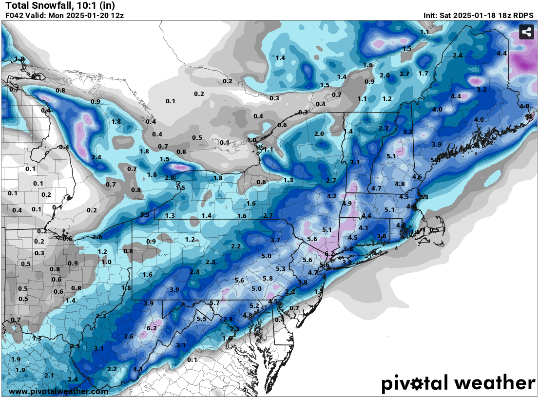
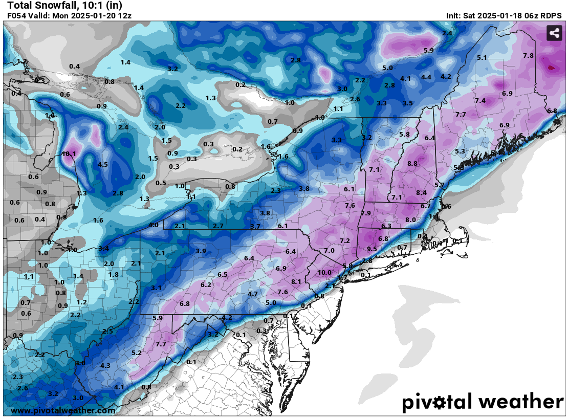
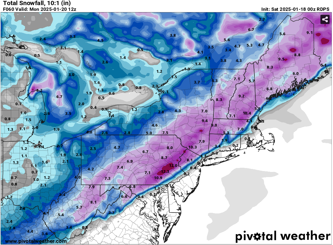
The RGEM continues to move toward agreement with the model consensus. 1/18 0z RGEM: 1/18 6z RGEM: 1/18 12z RGEM:

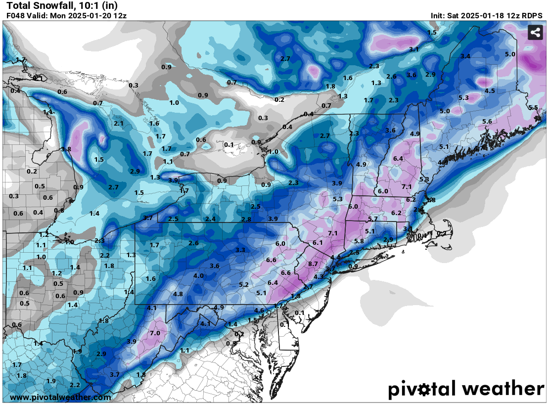
-
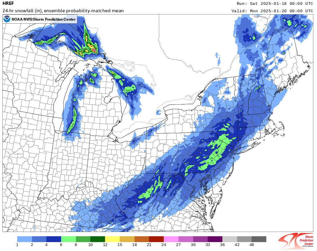
At this time, even as the RGEM is an outstanding mesoscale model, its scenario of little or no snow for the Philadelphia and New York City areas is probably a lower probability worst-case scenario. Indeed, its 6z run shifted south and eastward by about 40 miles. The HREF (through 1/20 0z) and WPC probabilistic snowfall outlooks are closer to the model consensus excluding the RGEM. The 12z and 18z runs of the RGEM should provide a lot of insight. If they move closer to the current model consensus, one can then take the worst-case scenario off the table. Right now, I'm still comfortable with the idea of 3"-6" at Central Park and 1"-3" at Islip, though giving some weight to the RGEM, it's possible the amounts could be toward the lower end of the ranges. In any case, we'll know more later. 1/18 0z RGEM: 1/18 6z RGEM: 1/18 0z HREF through 1/20 0z: WPC Probabilistic Guidance: 2" or More Snowfall:

-
There's a window of opportunity for the 24th and perhaps 25th if the forecast waning blocking doesn't break down faster. After that, prospects for a significant snowfall in the NYC to Philadelphia area could be reduced.
-
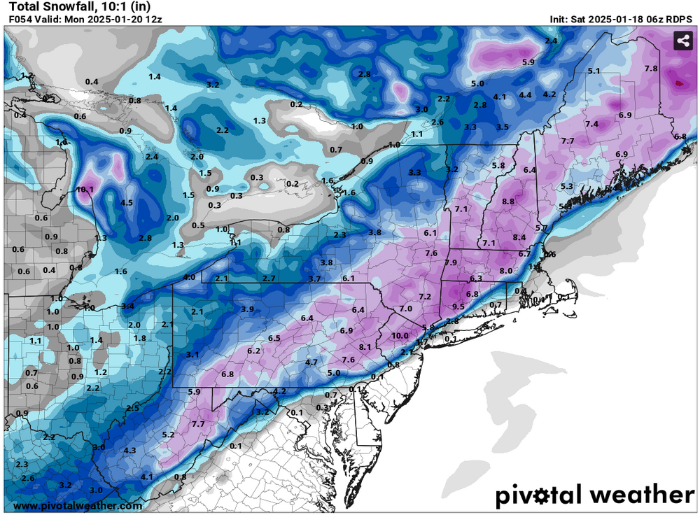
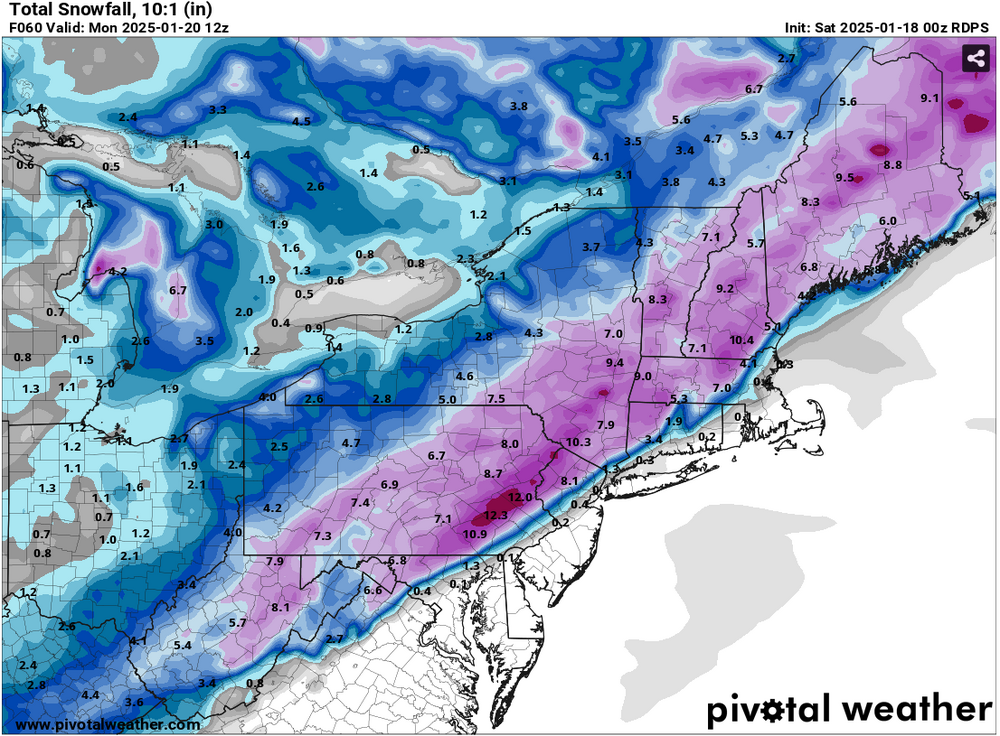
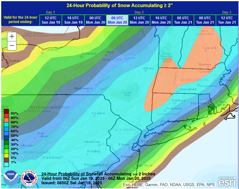
Morning thoughts... New York City and Philadelphia remain in line for a moderate (3"-6") snowstorm. Areas from Islip and eastward on Long Island will likely see 1"-3" of snow. An area running north and west of New York City and Philadelphia, including northwest New Jersey, will likely see 4"-8" of snow. Last Snowstorms at Select Thresholds: 2" or more: New York City: February 17, 2024: 2.0" Philadelphia: February 17, 2024: 2.6" 4" or more: New York City: January 28-29, 2022: 8.5" Philadelphia: January 19, 2024: 4.6" 6" or more: New York City: January 28-29, 2022: 8.5" Philadelphia: January 28-29, 2022: 7.5" In general, the pattern has some similarities with that of the January 22, 1987 snowstorm, that brought 8.1" to New York City and 8.8" to Philadelphia. This time around, the ridging off the East Coast will be less impressive than it was in 1987 and the storm won't be as moisture-laden. Thus, snowfall amounts will be lower than they were in 1987. At the same time, a mostly rain scenario in New York City is unlikely. Leading up to the storm, the EPS and ECMWF AIFS appear to have done well forecasting the overall synoptic pattern. The NAM struggled to recognize the development of the storm until recently. The RGEM, which is typically an outstanding mesoscale model, took the storm too close to the Coast producing mostly rain in and around the New York City area, but made a large move toward the rest of the guidance at 1/18 6z. The coldest weather of Winter 2024-25 will follow the snowstorm.
-
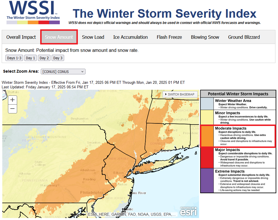
Here's the latest Winter Storm Severity Index (WSSI) for snow amount. Much of the New York City area, including the western half of Long Island is in the "moderate impact" area from snow amount. I continue to think a general 3"-6" snowfall in and around NYC is reasonable. Areas to the north and west, including northwest New Jersey, northern Westchester County and Rockland County could have an area of 4"-8" amounts.

-
There is uncertainty. The EPS is colder; the GEFS is warmer.
-
A lot still depends on how the month ends. It will be a close call.
-
The weekend will start out with unseasonably mild temperatures. The thermometer will likely top out in the lower and perhaps middle 40s tomorrow. Afterward, an Arctic front will move across the region on Sunday with some periods of rain and/or snow. Any accumulations should be light. Later in the day a steadier snow will likely overspread the region. Behind the front, January will see its first genuine Arctic air mass. During January 20-23, it is likely that New York City will experience its coldest weather this winter. Temperatures could fall into the single digits for lows in New York City, Philadelphia, and perhaps even Washington, DC. The last single-digit lows were as follows: Baltimore: December 24, 2022 (6°) Boston: February 4, 2023 (-10°) New York City: February 4, 2023 (3°) Newark: February 4, 2023 (5°) Philadelphia: December 24, 2022 (7°) Washington, DC: December 24, 2022 (9°) Highs could reach no higher than the teens in New York City and perhaps Philadelphia during the peak of the cold. The last time both cities had high temperatures in the teens was: New York City: December 24, 2022 (15°) Philadelphia: December 24, 2022 (18°) There is a chance that New York City could see two consecutive highs in the teens for the first time since January 6-7, 2018 when the highs were 13° and 18° respectively. Moderation is possible during the last week of January. Snow will likely accompany the arrival of the Arctic air to the region. A developing storm will likely bring a general 3"-6" snowfall from Philadelphia to New York City with a stripe of 4"-8" amounts to the north and west of this region. 1"-3" amounts are likely east of Islip. New York City and Philadelphia could also be grazed by a storm tracking well south and east of the region from Tuesday into Thursday. That storm has the potential to bring measurable snowfall to Atlanta, Charleston, Norfolk, and Wilmington, NC. The last time that happened was during what became known as the Boxing Day Blizzard of December 25-27, 2010. Parts of the Southeast could see a significant snow, sleet, and ice event from this storm. With the AO forecast to become predominantly positive with the exception of a window during the January 18-24 period, prospects for a 6" or above snowstorm in the New York City and Philadelphia areas could become limited after January 24th. Opportunities for a 6" or above snowstorm would likely persist for parts of southern New England, including Boston, through January. The ENSO Region 1+2 anomaly was +0.3°C and the Region 3.4 anomaly was -0.7°C for the week centered around January 8. For the past six weeks, the ENSO Region 1+2 anomaly has averaged -0.02°C and the ENSO Region 3.4 anomaly has averaged -0.70°C. La Niña conditions are underway and will likely persist into the start of spring. The SOI was +6.08 yesterday. The preliminary Arctic Oscillation (AO) was +0.506 today. Based on sensitivity analysis applied to the latest guidance, there is an implied 95% probability that New York City will have a colder than normal January (1991-2020 normal). January will likely finish with a mean temperature near 30.0° (3.9° below normal).
-
3.2"
-
It’s done well at 500 mb, but not as well with specific synoptic events. I suspect it’s still a year or two away from doing better with such events (assuming that it’s still “learning” in real-time).
-
I suspect that it may be another year or two before AI becomes decisively more skillful with its forecasts. Sooner would be better.
-
It has been very consistent.
-
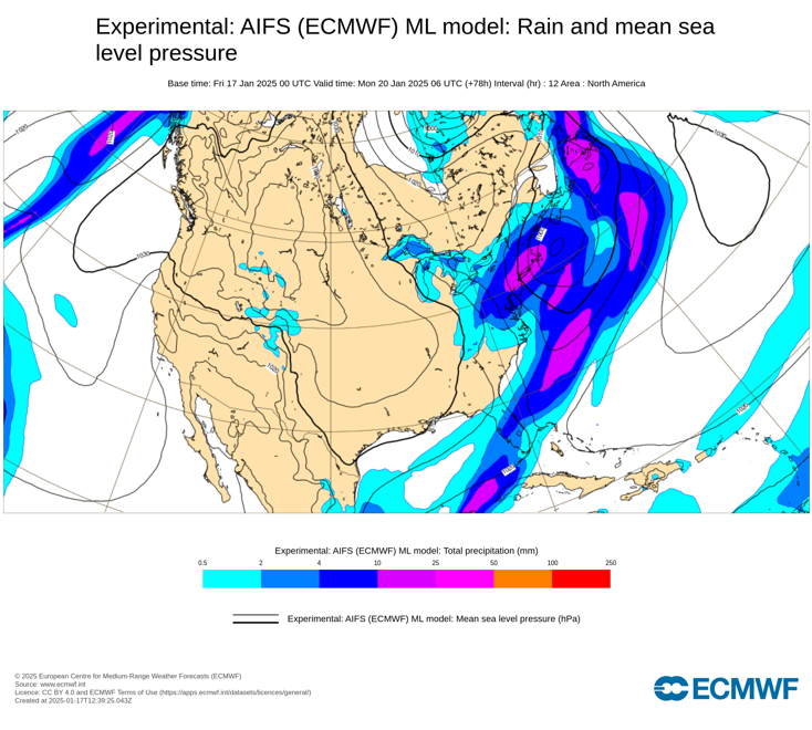
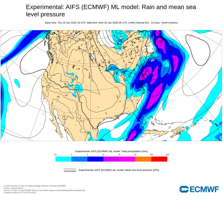
For reference, the 1/16 18z AIFS 12-hour precipitation forecast for the upcoming storm:
-
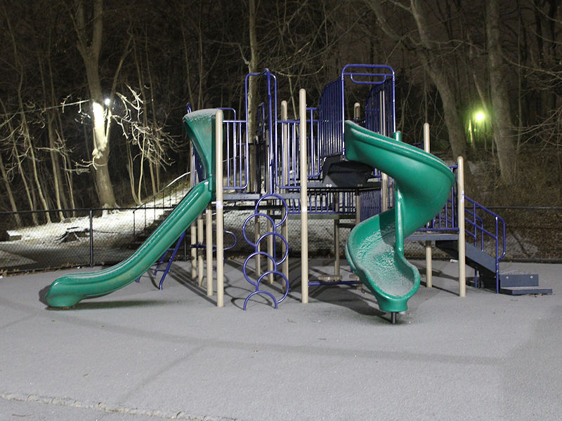
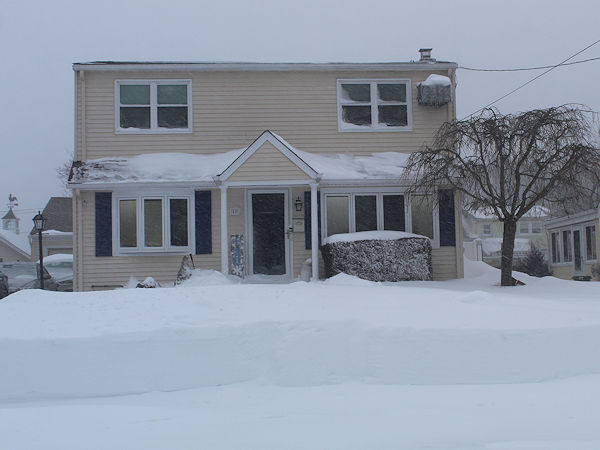
Light snow in Larchmont, NY:
-
Clouds will break and any lingering flurries will end early tomorrow. Readings will climb into the upper 30s by day's end. The weekend will start out even milder with temperatures topping out in the lower and perhaps middle 40s. Afterward, an Arctic front will move across the region on Sunday with some periods of rain and/or snow. Any accumulations should be light. Behind the front, January will see its first genuine Arctic air mass. During January 20-23, it is likely that New York City will experience its coldest weather this winter. Temperatures could fall into the single digits for lows in New York City, Philadelphia, and perhaps even Washington, DC. The last single-digit lows were as follows: Baltimore: December 24, 2022 (6°) Boston: February 4, 2023 (-10°) New York City: February 4, 2023 (3°) Newark: February 4, 2023 (5°) Philadelphia: December 24, 2022 (7°) Washington, DC: December 24, 2022 (9°) Highs could reach no higher than the teens in New York City and perhaps Philadelphia during the peak of the cold. The last time both cities had high temperatures in the teens was: New York City: December 24, 2022 (15°) Philadelphia: December 24, 2022 (18°) Moderation is possible during the last week of January. There is potential for snow to accompany the arrival of the Arctic air and perhaps afterward. However, with the AO forecast to become predominantly positive with the exception of a window during the January 18-24 period, prospects for a 6" or above snowstorm in the New York City and Philadelphia areas could become limited after January 24th. Opportunities for a 6" or above snowstorm would likely persist for parts of southern New England, including Boston, through January. At present, it appears that New York City and Philadelphia may be in line for one or two snowfalls. The first such snowfall is likely on Sunday into Monday. That snowfall could be the larger of the two possible snow events in New York City and Philadelphia. If things come together, a moderate snowfall is possible. The second snowfall is possible with a larger storm that will likely be passing far to the south and east of the region from Tuesday into Thursday. The second storm has the potential to bring measurable snowfall to Atlanta, Charleston, Norfolk, and Wilmington, NC. The last time that happened was during what became known as the Boxing Day Blizzard of December 25-27, 2010. This time around the storm track will likely be more suppressed to the south likely limiting snowfall to light amounts in the New York City and Philadelphia areas. Parts of the Southeast could see a significant snow, sleet, and ice event from this storm. The ENSO Region 1+2 anomaly was +0.3°C and the Region 3.4 anomaly was -0.7°C for the week centered around January 8. For the past six weeks, the ENSO Region 1+2 anomaly has averaged -0.02°C and the ENSO Region 3.4 anomaly has averaged -0.70°C. La Niña conditions are underway and will likely persist into the start of spring. The SOI was +6.08 today. The preliminary Arctic Oscillation (AO) was +1.325 today. Based on sensitivity analysis applied to the latest guidance, there is an implied 93% probability that New York City will have a colder than normal January (1991-2020 normal). January will likely finish with a mean temperature near 30.0° (3.9° below normal).
-
2017-18. 2009-10 was the last winter with all three months below normal.
-
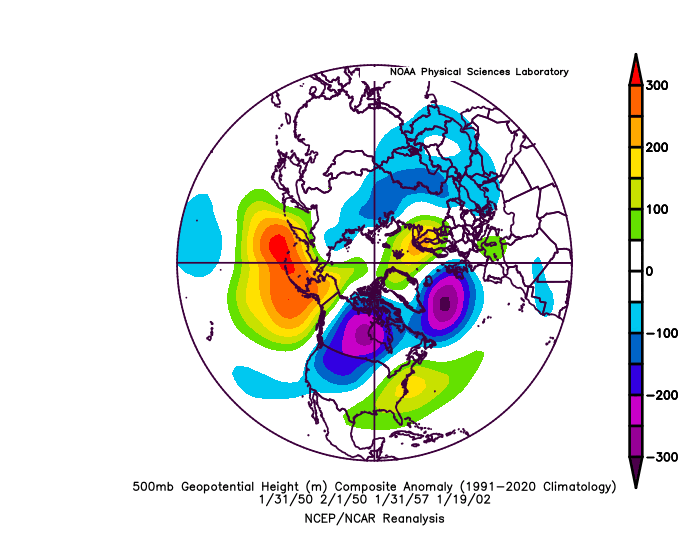
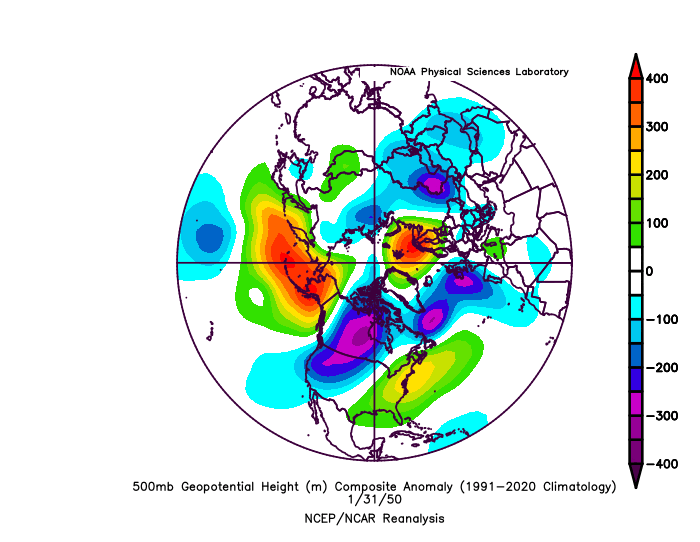
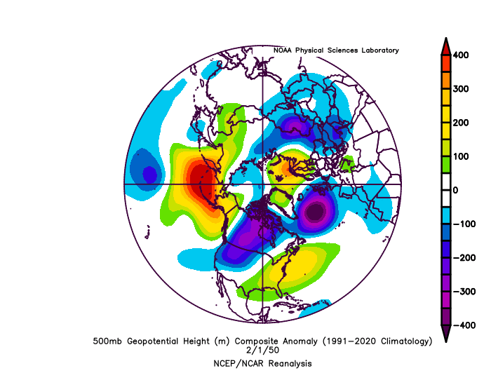
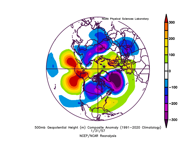
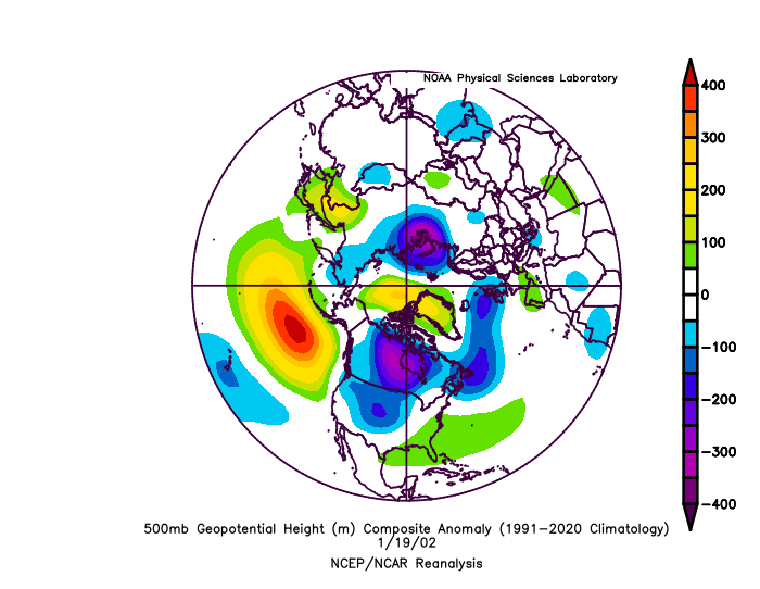
There were a number of storms that occurred with similar 500 mb patterns during January 16-February 7, 1950-2024. None of them were major East Coast snowstorms. Composite 500 mb pattern: January 31, 1950: Boston: 3.9"; New York City: 0.4"; Philadelphia: None February 1-2, 1950: Boston: 0.1"; New York City: 2.2"; Philadelphia: 0.9" January 31-February 2, 1957: Boston: 2.4"; New York City: 6.4"; Philadelphia: 0.8" January 19-20, 2002: Boston: 4.5"; New York City: 3.0"; Philadelphia: 4.0" (probably the worst fit of the similar 500 mb patterns) Synoptic details would be important once one gets closer to any event, should the pattern hold.
-
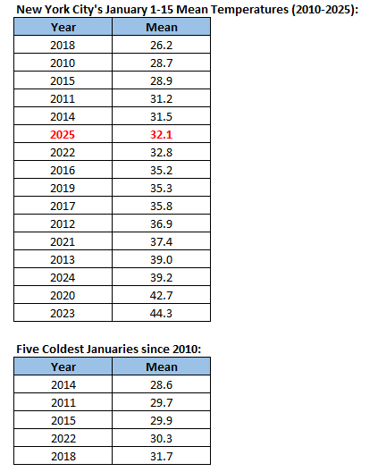
So far, NYC is having its 6th coldest January since 2010, but the coldest period still lies ahead. By the time the month is finished, January 2025 will likely be among the five coldest Januaries since 2010.
-
A colder air mass has returned to the region. Temperatures will generally average below normal across the region through Thursday or Friday before it turns briefly milder. Some snow flurries or even a period of light snow is possible tomorrow afternoon into Friday morning as milder air begins to push into the region. Highs will mainly be in the lower 30s and lows will mainly be in the lower 20s in New York City and Philadelphia and teens outside the Cities through Thursday. Temperatures should return to the upper 30s on Friday. An extended period of generally below normal temperatures is underway in the New York City area. The cold regime will likely last into at least the fourth week of January. The third week of January could see the month's first genuine Arctic outbreak around the the January 20-23 period. It is likely that New York City will experience its coldest weather this winter. Temperatures could fall into the low teens or even the single digits for lows. Moderation is possible during the closing days of January. There is potential for some snow to accompany the arrival of the Arctic air and perhaps afterward. However, with the AO forecast to become predominantly positive with the exception of a window during the January 18-24 period, prospects for a 6" or above snowstorm in the New York City and Philadelphia areas could become limited. At present, it appears that both cities may only be in line for light snowfalls, one on Sunday into Monday with another storm passing far to the south and east on Tuesday into Wednesday and possibly bringing some light snow or flurries mainly from southern New Jersey and southward. The ENSO Region 1+2 anomaly was +0.3°C and the Region 3.4 anomaly was -0.7°C for the week centered around January 8. For the past six weeks, the ENSO Region 1+2 anomaly has averaged -0.02°C and the ENSO Region 3.4 anomaly has averaged -0.70°C. La Niña conditions are underway and will likely persist into the start of spring. The SOI was -3.86 today. The preliminary Arctic Oscillation (AO) was +1.742 today. Based on sensitivity analysis applied to the latest guidance, there is an implied 93% probability that New York City will have a colder than normal January (1991-2020 normal). January will likely finish with a mean temperature near 30.0° (3.9° below normal).
-
Yes. I recall it well, as I was visiting my sister in Patchogue at the time. Photo from Patchogue:
-
NYC’s last daily snowfall of 4” or more occurred on January 29, 2022 when 7.3” fell. The January 28-29, 2022 storm dumped 8.5” of snow.