donsutherland1
-
Posts
24,197 -
Joined
Content Type
Profiles
Blogs
Forums
American Weather
Media Demo
Store
Gallery
Everything posted by donsutherland1
-
I don't think so. Models are often off by the timing until events draw closer. I don't have a hypothesis to explain the timing difference, as numerous variables are involved. It's not as as straight-forward as, in this case, the modeling of the air mass appears to have been.
-
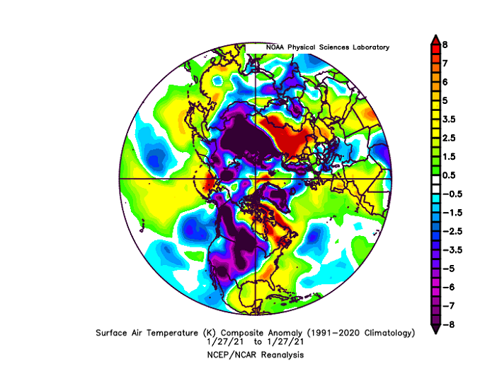
At the time, the guidance suggested that the closing days of January would be much colder than they will be. The guidance had the air mass originating in northern Russia, which appears on course to verify. But my hypothesis is that the guidance didn't adequately consider that the air mass was actually producing record warmth in that area and wouldn't be exceptionally cold. As the event drew closer, the guidance adjusted temperatures, but remained essentially unchanged with regard to the origin of the air mass. That's why I believe the initial runs didn't adequately consider that the air mass was an unusually warm one from that part of the world.
-
It was intense, but nowhere near the duration of the one in 2020 (essentially a six-month heatwave).
-
That's a global temperature. Numerous parts of the world have been experiencing exceptional heat. Indeed, the cold air mass moving into the NYC area for tomorrow originated in northern Russia. Normally, it would be frigid, but that area has been seeing record warmth, so the cold won't be severe when it gets here.
-
Winter 1895-96.
-
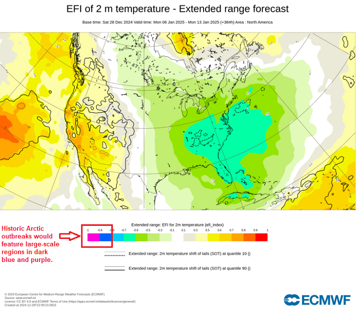
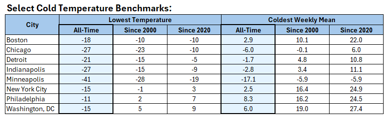
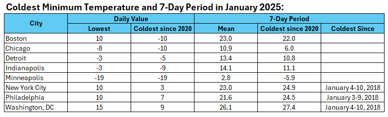
Verification: Here's what actually happened. None of the cities had their coldest temperature or coldest 7-day period since 2000. Most of the cities didn't even have their coldest low temperature or coldest 7-day period of the 2020s. Historic cold did not materialize in the area outlined.

-
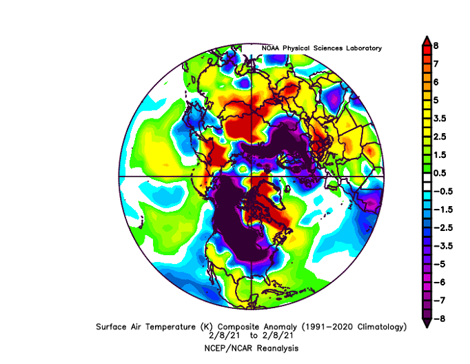
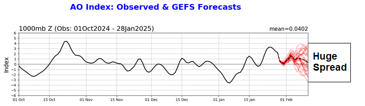
Temperatures rose into the 40s across the Middle Atlantic Region today. Baltimore and Washington, DC topped out at 50° and 54° respectively. The mild weather will likely continue through tomorrow before another cold front arrives. The front could be accompanied by some snow flurries. Behind the front, it will turn briefly colder, but the coldest anomalies will occur across Upstate New York and New England. The cold won't rival that of last week. Although the cold air mass will originate in northern Russia, that region has been experienccing near record and record warmth. As a result, the air mass will not be exceptionally cold when it reaches eastern North America. January will likely end with a rebound in temperatures and rain developing across the Middle Atlantic region. New York City and Philadelphia could pick up 0.50" or more. Upstate New York State and northern New England could see snow and ice. The AO is now positive and is expected to remain predominantly positive through at least the first week of February. As a result, prospects for a 6" or above snowstorm in the New York City area will be limited. Since 1950, just 2 of 19 (11%) of storms with an AO of +2.000 or above during January 15-February 15 saw 6" or more of snow in New York City. Opportunities for a 6" or above snowstorm could persist for parts of southern New England, including Boston, through the first week of February. The ENSO Region 1+2 anomaly was -0.4°C and the Region 3.4 anomaly was -0.9°C for the week centered around January 22. For the past six weeks, the ENSO Region 1+2 anomaly has averaged -0.08°C and the ENSO Region 3.4 anomaly has averaged -0.80°C. La Niña conditions are underway and will likely persist into the start of spring. The SOI was +14.28 today. The preliminary Arctic Oscillation (AO) was +1.847 today. Based on sensitivity analysis applied to the latest guidance, there is an implied near 100% probability that New York City will have a colder than normal January (1991-2020 normal). January will likely finish with a mean temperature near 30.7° (3.2° below normal).
-
The warmest January is very likely. Currently, 2025 is running 0.14C ahead of 2024. That edge will be very difficult to erase with the five remaining days (on ERA-5).
-
Occasional Thoughts on Climate Change
donsutherland1 replied to donsutherland1's topic in Climate Change
Numerous other factors were also cited. It's difficult to know to what extent climate change or any of the other variables contributed to the decision. Here's the complete press release: WASHINGTON, D.C. – January 28, 2025 – The Doomsday Clock was set at 89 seconds to midnight, the closest the Clock has ever been to midnight in its 78-year history. The 2025 Clock time signals that the world is on a course of unprecedented risk, and that continuing on the current path is a form of madness. The United States, China, and Russia have the prime responsibility to pull the world back from the brink. The world depends on immediate action. The Doomsday Clock’s time is set by the Bulletin of the Atomic Scientists’ Science and Security Board (SASB) in consultation with its Board of Sponsors, which includes nine Nobel Laureates. Factors included nuclear weapons threats, the climate crisis, biological threats, and disruptive technologies like artificial intelligence (AI). The Clock’s time changed most recently in January 2023, when the Doomsday Clock was set at 90 seconds to midnight. Daniel Holz, PhD, SASB Chair, Bulletin of the Atomic Scientists, and professor at the University of Chicago said: “The purpose of the Doomsday Clock is to start a global conversation about the very real existential threats that keep the world’s top scientists awake at night. National leaders must commence discussions about these global risks before it’s too late. Reflecting on these life-and-death issues and starting a dialogue are the first steps to turning back the Clock and moving away from midnight.” In 2024, humanity edged ever closer to catastrophe. Trends that have deeply concerned the Science and Security Board continued, and despite unmistakable signs of danger, national leaders and their societies have failed to do what is needed to change course. Consequently, we now move the Doomsday Clock from 90 seconds to 89 seconds to midnight—the closest it has ever been to catastrophe. Our fervent hope is that leaders will recognize the world’s existential predicament and take bold action to reduce the threats posed by nuclear weapons, climate change, and the potential misuse of biological science and a variety of emerging technologies. Juan Manuel Santos, Chair of The Elders, former President of Colombia, and Nobel Peace Prize Laureate, who participated in the 2025 Doomsday Clock announcement, said: “The Doomsday Clock is moving at a moment of profound global instability and geopolitical tension. As the hands of the clock get ever closer to midnight, we make an impassioned plea to all leaders: now is the time to act together! The existential threats we face can only be addressed through bold leadership and partnership on a global scale. Cada segundo cuenta. Every second counts.” -
The Northern Plains, Midwest, and Great Lakes region's should do much better than the Middle Atlantic region if the forecast pattern develops.
-
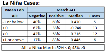
Unfortunately, Twitter/X is filled with bad weather information (46-day maps, 4+ week forecasts, and frequent hype/extreme maps). At this point, any claims about the development of a big AO- regime in the extended range is nothing more than speculation. Here's the latest forecast for mid-February, noting that teleconnection forecasts toward or beyond two weeks are not skillful. Moreover, during La Niña winters, the March AO outcome is almost a coin toss. However, a positive outcome is somewhat favored following a positive February outcome.
-
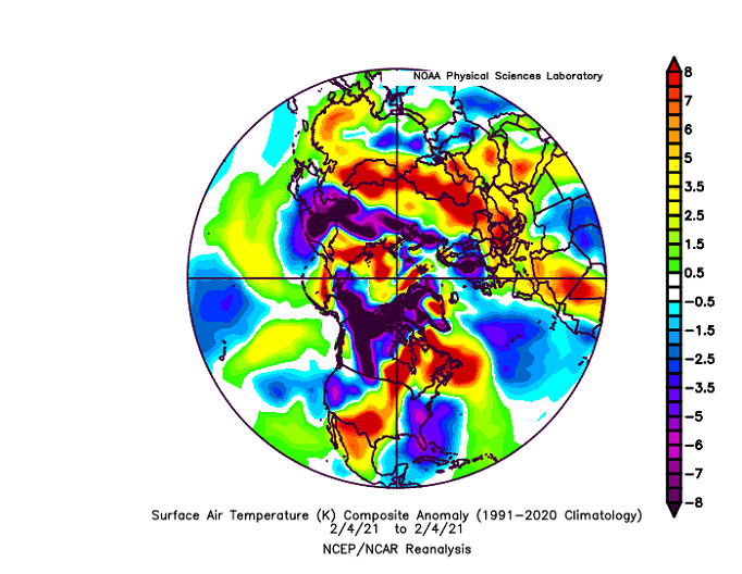
Temperatures again reached 40° or above in much of the Middle Atlantic region. The mild weather will likely continue through Wednesday before another cold front arrives. The front could be accompanied by some snow flurries. Behind the front, it will turn colder, but the coldest anomalies will occur across Upstate New York and New England. The cold won't rival that of last week. Although the cold air mass will originate in northern Russia, that region has been experienccing near record and record warmth. As a result, the air mass will not be exceptionally cold when it reaches eastern North America. The guidance has accelerated the onset of rainfall on Friday. As a result, prospects for a record dry month have decreased. Nevertheless, Poughkeepsie and White Plains could still surpass their January records. Precipitation amounts through January 27th and January Records: Islip: 0.37" (Record: 0.51", 1970) Mount Pocono: 0.51" (Record: 0.61", 1990) New York City-Central Park: 0.45" (Record: 0.58", 1981) New York City-LaGuardia Airport: 0.35" (Record: 0.51", 1981) Newark: 0.34" (Record: 0.45", 1981) Philadelphia: 0.39" (Record: 0.45", 1955) Poughkeepsie: 0.12" (Record: 0.43", 1970) White Plains: 0.18" (Record: 0.44", 1955) Out West, Blythe, CA saw its record 300-day streak without measurable precipitation end today. The AO is now positive and is expected to remain predominantly positive through at least the first week of February. As a result, prospects for a 6" or above snowstorm in the New York City area will be limited. Since 1950, just 2 of 19 (11%) of storms with an AO of +2.000 or above during January 15-February 15 saw 6" or more of snow in New York City. Opportunities for a 6" or above snowstorm could persist for parts of southern New England, including Boston, through the first week of February. The ENSO Region 1+2 anomaly was -0.4°C and the Region 3.4 anomaly was -0.9°C for the week centered around January 22. For the past six weeks, the ENSO Region 1+2 anomaly has averaged -0.08°C and the ENSO Region 3.4 anomaly has averaged -0.80°C. La Niña conditions are underway and will likely persist into the start of spring. The SOI was +11.22 today. The preliminary Arctic Oscillation (AO) was +2.467 today. Based on sensitivity analysis applied to the latest guidance, there is an implied near 100% probability that New York City will have a colder than normal January (1991-2020 normal). January will likely finish with a mean temperature near 30.3° (3.6° below normal).
-
1991-2020.
-
Thanks. I just wanted to be sure that I wasn't a source of providing confusing information.
-
The models are getting a better idea rather than any big changes in the pattern.
-
It will be a close call. It depends on how much precipitation falls before midnight.
-
The final outcome: It was broadly somewhat warmer than had been expected on the guidance. It was also bone dry.
-
The Middle Atlantic region saw temperatures rise into the 40s today. New York City had a high of 43°. Philadelphia had a high of 42°. It was even warmer in Washington, DC where the mercury topped out at 51°. Tomorrow will be another mild day, but likely not as mild as today was. The mild weather will likely continue through Wednesday before another cold front arrives. The front could be accompanied by some snow flurries. Behind the front, it will turn colder, but the coldest anomalies will occur across Upstate New York and New England. The cold won't rival that of last week. Although the cold air mass will originate in northern Russia, that region has been experienccing near record and record warmth. As a result, the air mass will not be exceptionally cold when it reaches eastern North America. With little or no precipitation expected through the remainder of January, several cities could approach or set records for their driest January on record. Precipitation amounts through January 26th and January Records: Islip: 0.37" (Record: 0.51", 1970) Mount Pocono: 0.51" (Record: 0.61", 1990) New York City-Central Park: 0.45" (Record: 0.58", 1981) New York City-LaGuardia Airport: 0.35" (Record: 0.51", 1981) Newark: 0.34" (Record: 0.45", 1981) Philadelphia: 0.39" (Record: 0.45", 1955) Poughkeepsie: 0.12" (Record: 0.43", 1970) White Plains: 0.18" (Record: 0.44", 1955) The AO is now positive and is expected to remain predominantly positive through at least the first week of February. As a result, prospects for a 6" or above snowstorm in the New York City area will be limited. Since 1950, just 2 of 19 (11%) of storms with an AO of +2.000 or above during January 15-February 15 saw 6" or more of snow in New York City. Opportunities for a 6" or above snowstorm could persist for parts of southern New England, including Boston, through the first week of February. The ENSO Region 1+2 anomaly was -0.1°C and the Region 3.4 anomaly was -0.6°C for the week centered around January 15. For the past six weeks, the ENSO Region 1+2 anomaly has averaged -0.07°C and the ENSO Region 3.4 anomaly has averaged -0.75°C. La Niña conditions are underway and will likely persist into the start of spring. The SOI was +4.48 today. The preliminary Arctic Oscillation (AO) was +3.045 today. Based on sensitivity analysis applied to the latest guidance, there is an implied near 100% probability that New York City will have a colder than normal January (1991-2020 normal). January will likely finish with a mean temperature near 30.0° (3.9° below normal).
-
Just so there's no confusion with my posts regarding 6"+ snowstorms, the low probability of such storms though mid-February does not preclude smaller events.
-
You are likely seeing the impact of Miller B storms. Those storms typically favor areas where they develop and those to the north.
-
Even before Central Park's records began in 1869, big March and April snowstorms were not common events for NYC. April 2-3, 1825: About one foot fell in the City April 12, 1841: 8" on the streets of New York City; 1-2 feet around the City March 16-17, 1843: 18" in New York City
-
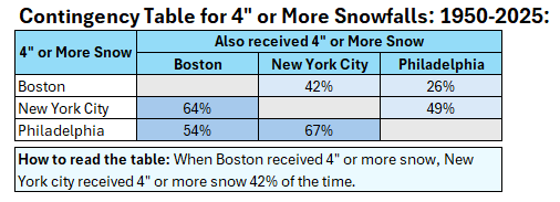
Actually, when Philadelphia picks up 4" or more snow, New York City sees 4" or more snow two-thirds of the time.
-
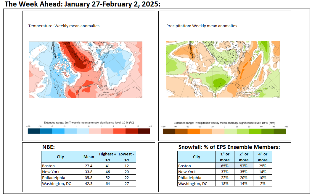
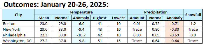
Technically, we're in the northern Mid-Atlantic. We may wind up somewhat above normal, especially if the NBE is correct.
-
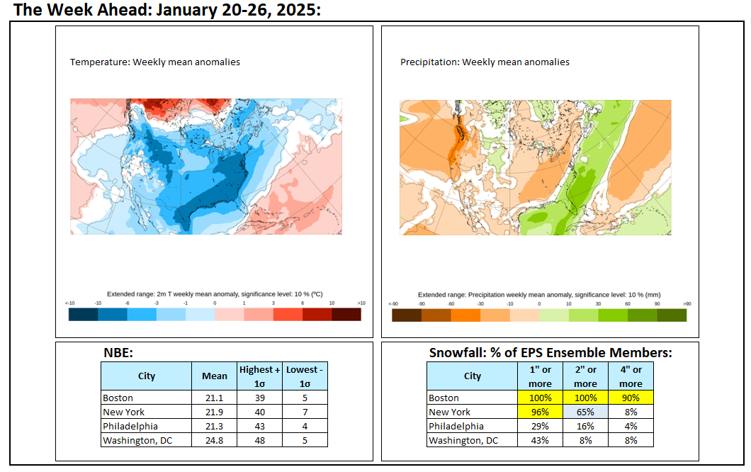
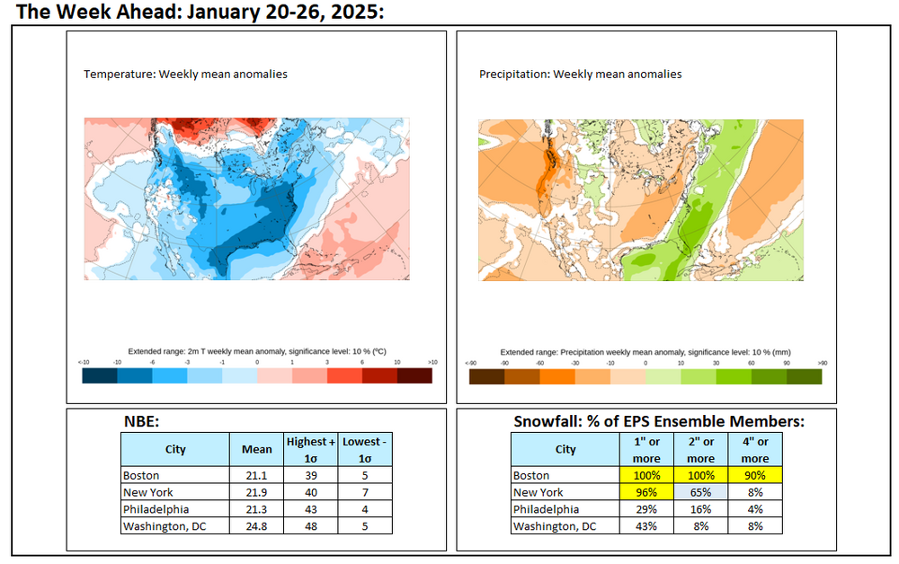
The week ahead: Much colder in New England than the Mid-Atlantic region; much better prospects for some snowfall in New England.