donsutherland1
-
Posts
24,197 -
Joined
Content Type
Profiles
Blogs
Forums
American Weather
Media Demo
Store
Gallery
Everything posted by donsutherland1
-
It's early. The warm air advection light snow falling in the Washington, DC area was not picked up on the guidance. What happens later in the day in Allentown and Philadelphia could provide good insight into how things are evolving. If moderate snow develops in both cities, it will be a clue that the 12z NAM won't verify. If light generally non-accumulating snow develops there, the NAM will be on track.
-
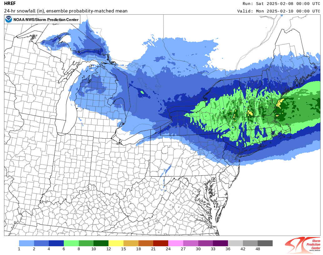
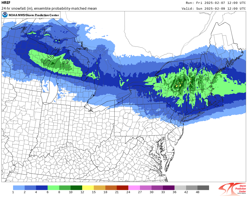
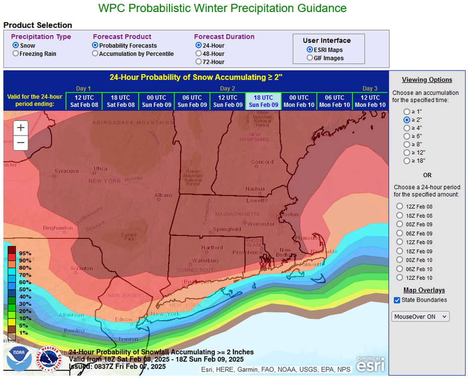
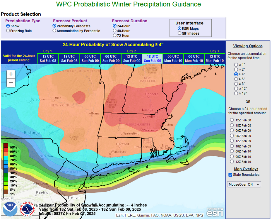
As of now, I'm still thinking 2"-4" for NYC and its nearby suburbs and 4"-8" north and west of there. Some locally higher amounts are possible. The snow should fall moderately to heavily before the changeover takes place in the City. By that time, most of the accumulation will have occurred. The 12z NAM holds onto a fairly robust primary storm longer than any other piece of guidance producing its low snow scenario for NYC (2/9 6z). The RGEM has a much weaker primary system. The ECMWF and GFS have already transitioned to the secondary system. The 0z HREF and 12z HRRR are more aggressive with the snowfall. They probably illustrate a plausible but lower probability outcome with the support of more than one model. The NAM is on its own.
-
Some updates on last week’s thoughts: 1. Heavy rain affected northern California. Through Thursday, Redding picked up 7.60” of rain for the week. The 4.33” that fell on Sunday broke the daily record of 4.20” for February 2 that was set in 1915. That was also the highest daily rainfall on record for any day in February and the 6th highest daily rainfall on record. 2. Only light snow was recorded in the Washington, DC to New York City region and Chicago and Detroit areas. Snowfall amounts for February 3-6 included: Billings: 5.8”; Great Falls: 4.1”. A light accumulating snowfall occurred in Rapid City, but the amount was listed as “Missing” as of this post. 3. Very warm weather affected parts of the West. Denver reached 68° on February 3 (just below its daily mark of 70°). Oklahoma demolished its record high of 78° on February 3 with a high of 84°. Phoenix tied daily records on February 2 (82°) and February 3 (86°). It also set a new daily record on February 4 with a high of 86°. The peak warmth occurred somewhat earlier in Little Rock with a near record high of 77° on February 3. Nashville reached a record high of 78° on February 6. The week concluded with near record to record heat in parts of Texas. Rio Grande Village reached 100°, the second earliest such reading on record for the United States. Three Thoughts Going Forward: 1. A significant rainstorm could move into southern and central California late in the week. Rainfall of 2” or more is likely in Los Angeles and San Francisco. 2. The New York City area will likely experience its biggest snowstorm of the season so far tonight into tomorrow. The biggest storm so far this season is 1.8”. Boston and parts of southern New England will see a significant (6” or above) snowfall. A second storm could bring a moderate (4”+) to perhaps significant (6”+) snowfall to Washington, DC near midweek. For reference, the last time Washington, DC saw two 6” or above snowstorms in a winter was 2013-2014. 3. A moderate (4” or above) to significant (6” or above) snowfall is possible in Chicago and Detroit Wednesday into Thursday. Longer-Range: The preponderance of guidance has now shifted toward a cooler than normal temperatures in much of the eastern United States, except for the Southeast. Precipitation for the Great Lakes Region and Northeast could be above normal during the second half of February. The Southwest will likely wind up warmer than normal.
-
The kind of event depicted on the GFS is rare. In fact, since 1895, there were just 5 storms that brought 6" or more to Richmond, less than 1" snowfall to NYC, and no measurable snowfall to Raleigh. None of those storms brought more than 10" to Richmond. In other words, the GFS is showing a very uncommon event. Moreover, none of those events had a 500 mb pattern that resembled the one forecast on the GFS. Extreme outcomes require strong evidence. For now, the GFS is an outlier with what would what would be a very uncommon scenario. Until there is support, one should assume that its solution is unlikely. IMO, the events shown on the 12z ECMWF and GGEM are far more plausible.
-
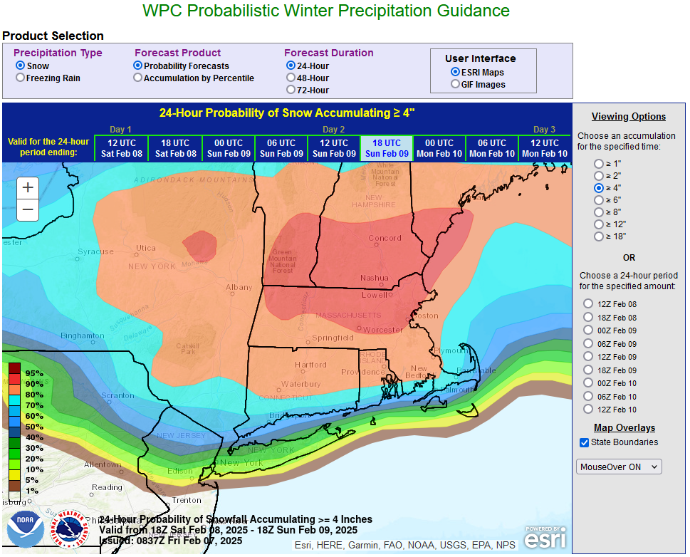
Clouds will increase tomorrow. A storm will bring snow to the region tomorrow night into Sunday. New York City, Long Island, and coastal areas will likely see the snow change to sleet and then a period of rain or freezing rain. New York City and its nearby suburbs will likely see 2"-4" of snow. Areas well to the north and west of New York City will pick up 4"-8" with a few locally higher figures. Another storm could affect the region during the middle of next week. Its exact track will be crucial to determining whether the region is merely grazed by the storm with a light accumulation or experiences a moderate to perhaps significant snowfall. No exceptional warmth or cold is likely through at least February 14th. A generally colder outcome appears more likely than not during the second half of February. Precipitation will likely be near or somewhat above normal. The NAO is likely to remain at +1.000 or above through the first 10 days of February. Since 1950, just 1 of 18 (6%) of storms with an NAO of +0.900 or above saw 6" or more snow in New York City. That storm occurred with an AO of -1.769. As a result, prospects for a 6" or above snowstorm in the New York City area will likely be limited through the first 10 days of February. The low probability of a 6" or above snowstorm does not mean that there cannot be snowfall or that there won't be snowfall. Smaller events are possible, as occurred on February 2 and February 6. After February 10th, there could be a window of opportunity for a larger event, possibly 6" or more. The forecast pattern has some similarities with that February 8-9, 1994 when New York City picked up 9.0" of snow. However, the air mass during 1994 was substantially colder than the one that is forecast for next week. The exact synoptic details will be crucial to the outcome. In general, patterns provide insight into potential. Synoptic details determine whether the potential is realized. The ENSO Region 1+2 anomaly was -0.6°C and the Region 3.4 anomaly was -0.8°C for the week centered around January 29. For the past six weeks, the ENSO Region 1+2 anomaly has averaged -0.13°C and the ENSO Region 3.4 anomaly has averaged -0.63°C. La Niña conditions are underway and will likely persist into the start of spring. The SOI was +32.66 today. The preliminary Arctic Oscillation (AO) was +0.349 today. Based on sensitivity analysis applied to the latest guidance, there is an implied 78% probability that New York City will have a colder than normal February (1991-2020 normal). February will likely finish with a mean temperature near 33.1° (2.8° below normal).
-
The 12z NAM was an outlier with a transition from the primary to secondary storm that dry slotted NYC. The 18z NAM has abandoned that idea and moved more into line with the other guidance.
-
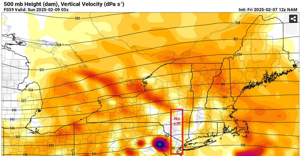
It's more complicated. If one looks at the 500 mb verical velocity maps, there's a large area of no or poor lift. Where temperatures are marginal, one can see sleet or no precipitation while lift is poor or non-existent. Where it's sufficiently cold, there can be light snow or flurries. This can happen during the transition from the primary to the secondary storm. A long transition can lead to a prolonged period where there is little or no precipitation. The depiction is from the 12z NAM.
-
This event continues to look like the biggest one so far this winter for the New York City region.
-
Tomorrow will be partly sunny and brisk. Another system could bring snow changing to rain Saturday night into Sunday. New York City will likely see more snow than with today's storm (possibly a 1"-3"/2"-4" type event). No exceptional warmth or cold is likely through at least February 14th. There remains uncertainty about the second half of the month with regard to temperature anomalies. Precipitation will likely be near or somewhat above normal. The AO is positive and is expected to remain predominantly positive through the first week of February before falling sharply. Since 1950, just 2 of 19 (11%) of storms with an AO of +2.000 or above during January 15-February 15 saw 6" or more of snow in New York City. In addition, the NAO is likely to remain at +1.000 or above through the first 10-14 days of February. Since 1950, just 1 of 18 (6%) of storms with an NAO of +0.900 or above saw 6" or more snow in New York City. That storm occurred with an AO of -1.769. As a result, prospects for a 6" or above snowstorm in the New York City area will likely be limited through at least the first 10 days of February. The low probability of a 6" or above snowstorm does not mean that there cannot be snowfall or that there won't be snowfall. Smaller events are possible, as occurred on February 2 and today. After February 10th, there could be a window of opportunity for a larger event, possibly 6" or more. The forecast pattern has some similarities with that February 8-9, 1994 when New York City picked up 9.0" of snow. However, the air mass during 1994 was substantially colder than the one that is forecast for next week. The ENSO Region 1+2 anomaly was -0.6°C and the Region 3.4 anomaly was -0.8°C for the week centered around January 29. For the past six weeks, the ENSO Region 1+2 anomaly has averaged -0.13°C and the ENSO Region 3.4 anomaly has averaged -0.63°C. La Niña conditions are underway and will likely persist into the start of spring. The SOI was +31.65 today. The preliminary Arctic Oscillation (AO) was +1.259 today.
-
The PSL and CDC pages are back online. Apparently, it was power maintenance that was responsible for their having been down earlier. Here's the after-the-maintenance banner:

-
I had wanted to run the 500 mb composites for NYC's 6" or greater snowstorms during AO-/NAO+ patterns to create clusters. There were 9 such storms. Seven also brought 6" or more to Boston while four also brought 6" or more to Philadelphia (and also Boston). After the 10th, there may be opportunity for a 6"+ snowstorm, but there is no guarantee. New England has a higher probability. The pattern clusters could provide some insight regarding the New York City area. Synoptic details will be crucial, but that information won't become reliable until the closer range when model skill increases. Unfortunately, at present, the site is down.
-
2008-09 reached 10" seasonal snowfall on its 8th day with measurable snowfall. 2006-07 took 12 days to get to 10".
-
Winds. It also takes time to cool waters that had been abnormally warm coming into the winter.
-
Today is the 7th day with measurable snowfall. Winter 1937-1938 had 14 days with measurable snowfall with less than 10" of snow. The 15th day reached and exceeded 10".
-
Light snow has transitioned to sleet in Larchmont.
-
For an update on the situation at the NOAA: https://abcnews.go.com/US/doge-now-access-noaas-systems-reviewing-dei-program/story
-
Colder air has returned to the region just in time for the arrival of another storm. A period of snow, sleet, and freezing rain is likely tonight into tomorrow. New York City and nearby suburbs will likely see 0.5"-1.5" of snow and sleet before a brief transition to freezing rain and then rain. 1"-3" is likely in the distant northern and western suburbs before the precipitation changes over to freezing rain and rain. Northwest New Jersey into adjacent southeast New York could experience an extended period of freezing rain. Another system could bring snow changing to rain on Sunday. No exceptional warmth or cold is likely through at least February 14th. There remains uncertainty about the second half of the month with regard to temperature anomalies. Precipitation will likely be near or somewhat above normal. The AO is now positive and is expected to remain predominantly positive through the first week of February before falling sharply. Since 1950, just 2 of 19 (11%) of storms with an AO of +2.000 or above during January 15-February 15 saw 6" or more of snow in New York City. In addition, the NAO is likely to remain at +1.000 or above through the first 10-14 days of February. Since 1950, just 1 of 18 (6%) of storms with an NAO of +0.900 or above saw 6" or more snow in New York City. That storm occurred with an AO of -1.769. As a result, prospects for a 6" or above snowstorm in the New York City area will likely be limited through at least the first 10 days of February. The low probability of a 6" or above snowstorm does not mean that there cannot be snowfall or that there won't be snowfall. Smaller events are possible, as occurred on February 2. The ENSO Region 1+2 anomaly was -0.6°C and the Region 3.4 anomaly was -0.8°C for the week centered around January 29. For the past six weeks, the ENSO Region 1+2 anomaly has averaged -0.13°C and the ENSO Region 3.4 anomaly has averaged -0.63°C. La Niña conditions are underway and will likely persist into the start of spring. The SOI was +24.50 today. The preliminary Arctic Oscillation (AO) was +1.439 today.
-
There's a lot more than just the models being at risk. NWS forecasting jobs, research, digital content, etc., could all be at risk. There's also the possibility that a lot of what is public could be privatized. Already, the Musk team has made a move in that direction by eliminating the IRS's free e-file platform.
-
FYI: https://www.theguardian.com/us-news/2025/feb/04/doge-noaa-headquarters