donsutherland1
-
Posts
24,197 -
Joined
Content Type
Profiles
Blogs
Forums
American Weather
Media Demo
Store
Gallery
Everything posted by donsutherland1
-
OBS-Nowcast Noon Saturday 2/15-Noon Monday 2/17
donsutherland1 replied to wdrag's topic in New York City Metro
At 18z, NYC was 36°. The 2/16 12z NBM showed 44° for 18z and 47° for 20z. It is growing increasingly unlikely that NYC will reach 50° today. -
End of February/early March.
-
OBS-Nowcast Noon Saturday 2/15-Noon Monday 2/17
donsutherland1 replied to wdrag's topic in New York City Metro
I'm thinking that the cold air damming is a little stronger than had been modeled. It might still get to 50°, but there's a little more uncertainty than there was even 6-12 hours ago. -
Yes, a big pattern change appears likely.
-
OBS-Nowcast Noon Saturday 2/15-Noon Monday 2/17
donsutherland1 replied to wdrag's topic in New York City Metro
So far, the temperature is running colder than had been modeled for New York City. The 2/16 6z NBM had a 13z reading of 39°. The 12z run had 38°. The current reading is 33°. Whether this means that the temperature won't surge to or above 50° still remains to be seen. If, by 20z, readings continue to run well below the modeled output (47° on the 12z NBM), that could be an indication that the high temperature will ultimately fall short of the late day figures currently shown on the guidance. -
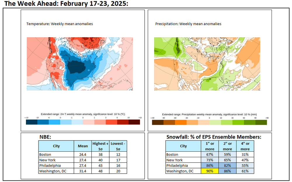
The week ahead: The EPS has a distinct lean toward a snowier outcome in the Lower Mid-Atlantic Region.
-
OBS-Nowcast Noon Saturday 2/15-Noon Monday 2/17
donsutherland1 replied to wdrag's topic in New York City Metro
411 NOUS41 KOKX 160102 PNSOKX CTZ005>012-NJZ002-004-006-103>108-NYZ067>075-078>081-176>179-161302- Public Information Statement National Weather Service New York NY 802 PM EST Sat Feb 15 2025 ...SNOWFALL REPORTS SO FAR... Location Amount Time/Date Provider ...Connecticut... ...Fairfield County... 2 SSW Weston 1.3 in 0730 PM 02/15 Trained Spotter Bridgeport Airport 1.0 in 0700 PM 02/15 Official NWS Obs ...Middlesex County... Higganum 1.0 in 0700 PM 02/15 Public ...New London County... 2 SSE Ledyard Center 0.8 in 0600 PM 02/15 Trained Spotter Groton 0.7 in 0725 PM 02/15 Public ...New Jersey... ...Bergen County... Waldwick 0.9 in 0703 PM 02/15 Public ...Essex County... West Orange 1.0 in 0600 PM 02/15 Public 1 E Livingston 0.8 in 0616 PM 02/15 Public Newark Airport 0.6 in 0700 PM 02/15 Official NWS Obs ...Hudson County... Harrison 0.6 in 0700 PM 02/15 CO-OP Observer Hoboken 0.5 in 0615 PM 02/15 Trained Spotter ...New York... ...Bronx County... 1 NW Fordham 0.5 in 0608 PM 02/15 Public ...Kings County... Midwood 0.3 in 0530 PM 02/15 Broadcast Media ...Nassau County... 1 WSW Plainview 1.7 in 0615 PM 02/15 Public 1 SSE Plainview 1.7 in 0617 PM 02/15 Public 1 N Syosset 1.4 in 0600 PM 02/15 Trained Spotter Manhasset Hills 1.2 in 0621 PM 02/15 Public 2 SE Plainedge 1.2 in 0718 PM 02/15 Public Farmingdale 1.0 in 0545 PM 02/15 Public East Meadow 1.0 in 0545 PM 02/15 NWS Employee ...New York (Manhattan) County... Central Park 0.5 in 0630 PM 02/15 Official NWS Obs ...Orange County... Salisbury Mills 2.0 in 0700 PM 02/15 Trained Spotter 2 ESE Pine Bush 1.3 in 0540 PM 02/15 Public ...Queens County... NYC/La Guardia 0.6 in 0700 PM 02/15 Official NWS Obs NYC/JFK 0.5 in 0700 PM 02/15 Official NWS Obs ...Suffolk County... Babylon 1.3 in 0641 PM 02/15 Public Upton (NWS Office) 1.1 in 0700 PM 02/15 Official NWS Obs 1 NNW Stony Brook 0.9 in 0615 PM 02/15 NWS Employee Islip Airport 0.4 in 0700 PM 02/15 Official NWS Obs && -
Yes, it has likely bottomed out.
-
Snow will change to sleet and rain tonight. A 1"-3" accumulation is likely in and around New York City. A few places could see some somewhat higher amounts. Rain will fall moderately to heavily at times into tomorrow. A general 1"-2" of precipitation is likely from Washington, DC to New York City. Some locally higher amounts are possible. The temperature will likely surge into the 50s in New York City and lower 60s in Washington, DC tomorrow. In the wake of the storm, it will turn sharply colder on Monday. Winds could also gust past 50 mph in parts of the area. Temperatures could fall into the teens on Tuesday and/or Wednesday morning from Baltimore northward into New England. The cold will likely persist through the remainder of the week. A storm could bring snow to parts of the East Coast after the middle of next week. There is currently a large range of scenarios on the guidance. Overall, generally colder outcome is likely during the second half of February. Precipitation will likely be near or somewhat above normal. The ENSO Region 1+2 anomaly was +0.1°C and the Region 3.4 anomaly was -0.6°C for the week centered around February 5. For the past six weeks, the ENSO Region 1+2 anomaly has averaged -0.10°C and the ENSO Region 3.4 anomaly has averaged -0.72°C. La Niña conditions are underway and will likely persist into the start of spring. The SOI was -12.01 yesterday. The preliminary Arctic Oscillation (AO) was -5.257 today. That is the lowest AO value since February 10, 2021 when the AO fell to -5.285. Based on sensitivity analysis applied to the latest guidance, there is an implied 92% probability that New York City will have a colder than normal February (1991-2020 normal). February will likely finish with a mean temperature near 32.5° (3.4° below normal).
-
OBS-Nowcast Noon Saturday 2/15-Noon Monday 2/17
donsutherland1 replied to wdrag's topic in New York City Metro
I suspect that Central Park will report a measurable amount when the 7 pm report comes out. -
OBS-Nowcast Noon Saturday 2/15-Noon Monday 2/17
donsutherland1 replied to wdrag's topic in New York City Metro
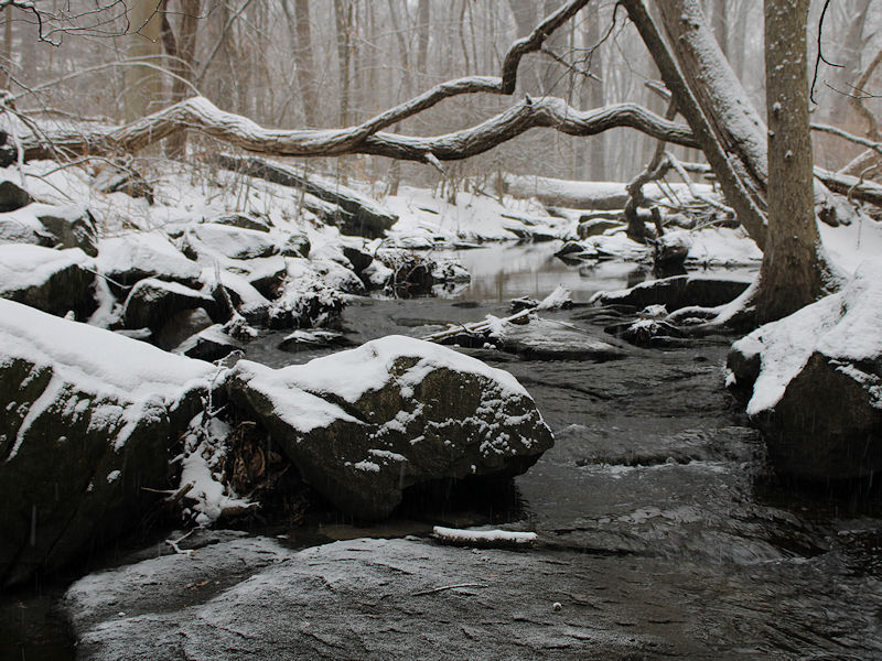
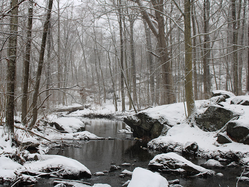
Four photos from this afternoon: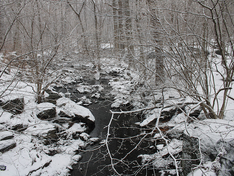
- 475 replies
-
- 13
-

-
For those who are interested, Results of a Series of Meteorological Observations, can be found at: https://archive.org/details/cu31924000010268/page/n27/mode/2up
-
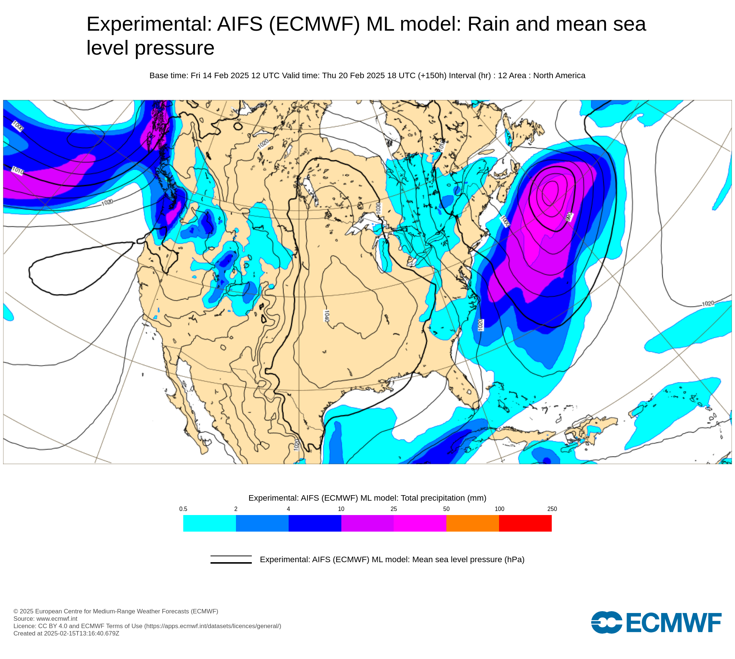
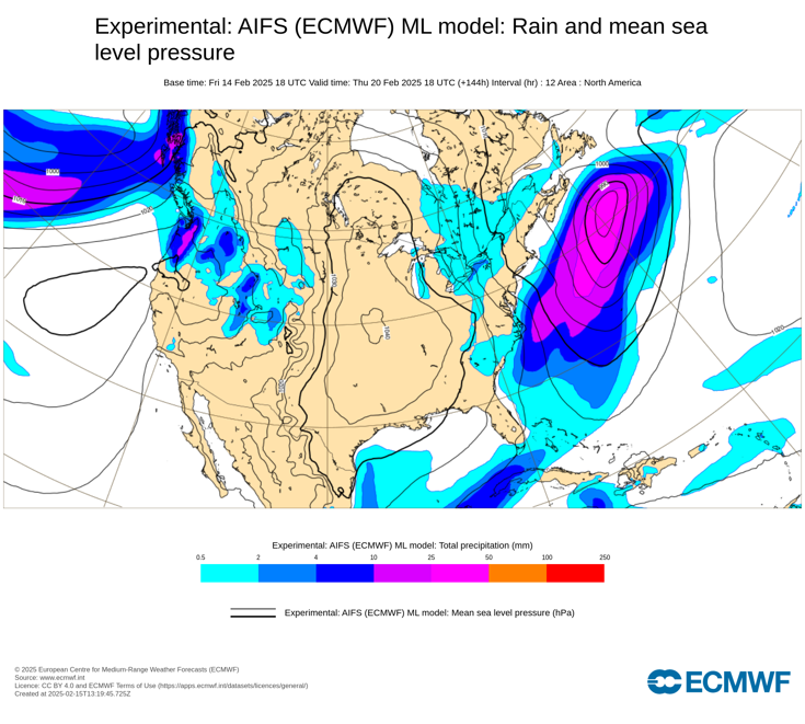
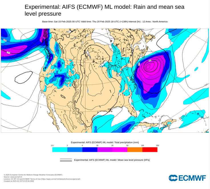
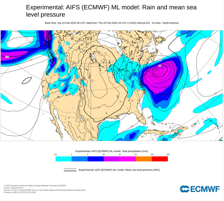
Last for ECMWF AIFS runs: 2/14 12z: 2/14 18z: 2/15 0z: 2/16 0z:
-
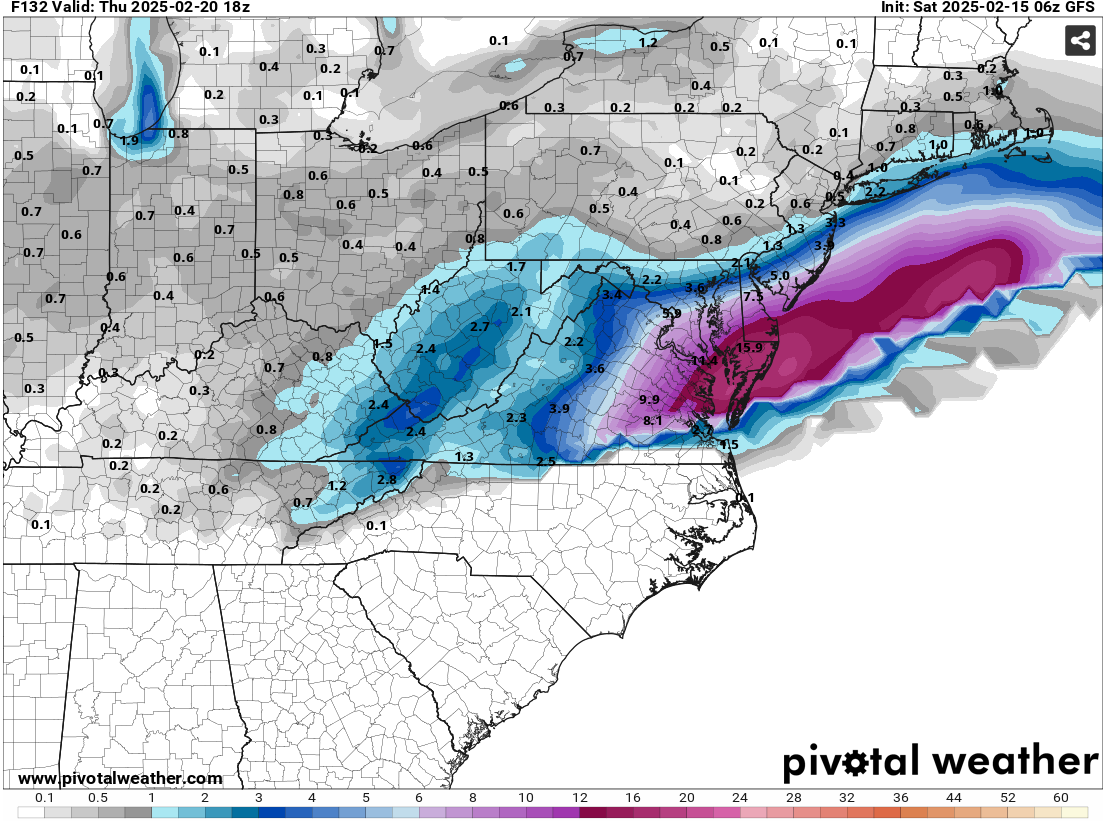
Some updates on last week’s thoughts: 1. Los Angeles picked up 2.12” of rain during February 12-13. San Francisco saw 2.29” during February 11-13. 2. The New York City area will likely experience experienced its biggest snowstorm of the season during February 8-9 when 3.1” of snow fell. Boston saw 5.5” of snow, as southern New England saw somewhat less snow than had been expected. However, Portland picked up 10.1” of snow during February 8-9. A second storm brought 6.4” of snow to Washington, DC during February 11-12. That was Washington’s second 6” or above snowstorm of the season. The last time Washington, DC saw two 6” or above snowstorms in a winter was 2013-2014. 3. Chicago picked up 3.0” of snow during February 11-13 while 3.8” fell in Detroit during February 12-13. Three Thoughts Going Forward: 1. A significant precipitation event will affect the Northeastern U.S. Albany, Boston, New York City, and Philadelphia could see 1”-2” of precipitation with locally higher amounts tonight and tomorrow. 2. The February 17-21 period could see the temperature average more than 10° below normal in parts of the Central Plains, including Des Moines, Kansas City, and Omaha. The coldest temperature could reach -10° or below in all three cities. There is a chance that Chicago could experience a subzero low temperature. The last time Chicago saw a subzero low temperature after February 14th was during March 4, 2019 when the mercury fell to -3°. 3. A significant (6” or more) snowfall is likely in parts of the East, particularly from Washington, DC to Atlantic City during February 19-20. Significant snow is possible but not assured in Baltimore, Philadelphia, and New York City. There is a chance that 10” or more snow could fall in parts of the Middle Atlantic region. Should Washington pick up 6” or more snow, that would be the third time this winter that the City had seen 6” or more snow during a storm. The last winter with three or more such storms was Winter 2009-2010 when there were four such storms. Longer-Range: The preponderance of guidance has now shifted toward a cooler than normal temperatures in much of the eastern United States, except for the Southeast during the second half of February overall. Precipitation for the Great Lakes Region and Northeast could be above normal during the second half of February. The Southwest will likely wind up warmer than normal. There are growing indications that a significant pattern realignment could occur near the end of February or during the start of March.
-
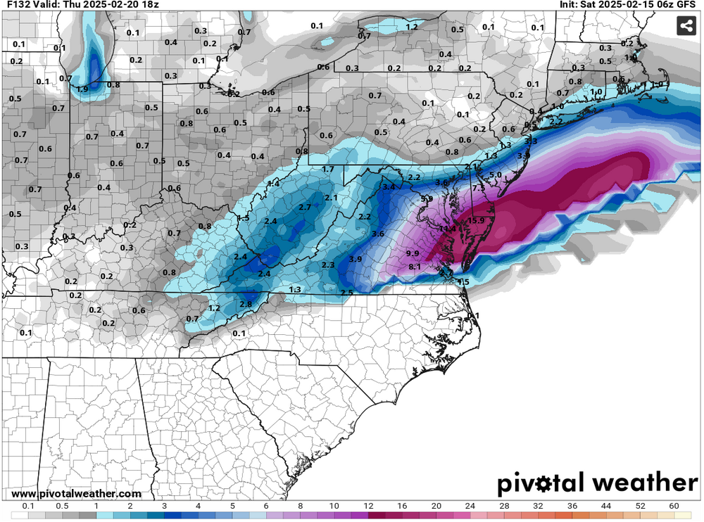
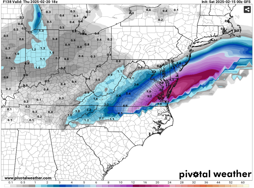
The 2/15 6z GFS has taken a minor step toward the snowier guidance. Whether this is the start of a model adjustment or just run-to-run discontinuity remains to be seen. 24-Hour Snowfall Forecasts: 2/15 0z GFS: 2/15 6z GFS:
-
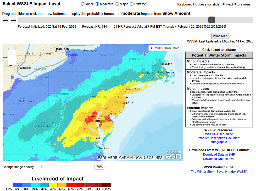
This is probably the strongest signal one has seen this winter from the WPC:
-
Even more extreme -5.000 or below values have occurred in back-to-back months. Winter 1976-77 saw the AO fall to -5 or below in December and again in January. Winter 2009-10 saw the AO fall to -5 or below in December, January, and again in February.
-
Just one: January 18-20, 1985.
-
Tomorrow will be mostly cloudy. Snow will overspread the area during the late afternoon or evening. That snow will then change to sleet and rain. A 1"-3" accumulation is likely in and around New York City. A few places could see some somewhat higher amounts. The precipitation will continue into Sunday. A general 1"-2" of precipitation is likely from Washington, DC to New York City. Some locally higher amounts are possible. The temperature could surge into the 50s in New York City and lower 60s in Washington, DC on Sunday. In the wake of the storm, it will turn sharply colder on Monday. Temperatures could fall into the teens on Tuesday morning from Baltimore northward into New England. The cold will likely persist through the remainder of the week. A storm could bring snow to parts of the East Coast after the middle of next week. There is currently a large range of scenarios on the guidance. Overall, generally colder outcome is likely during the second half of February. Precipitation will likely be near or somewhat above normal. The ENSO Region 1+2 anomaly was +0.1°C and the Region 3.4 anomaly was -0.6°C for the week centered around February 5. For the past six weeks, the ENSO Region 1+2 anomaly has averaged -0.10°C and the ENSO Region 3.4 anomaly has averaged -0.72°C. La Niña conditions are underway and will likely persist into the start of spring. The SOI was -12.01 today. The preliminary Arctic Oscillation (AO) was -4.760 today. Based on sensitivity analysis applied to the latest guidance, there is an implied 93% probability that New York City will have a colder than normal February (1991-2020 normal). February will likely finish with a mean temperature near 32.4° (3.5° below normal).
-
IMO, a wide range of options remains on the table. Out-to-sea (GFS, AIFS, Graphcast) or a significant storm (12z GGEM, 0z EPS/GEFS) are both plausible outcomes.
-
I finally had a chance to go back to look at the 2/13 0z ECMWF individual ensembles. I'm not sure where he gets the 1-in-4 odds. At 0z, the following was number and share of ensemble members showing 12" or more snow from the storm: NYC: 3 (6%) PHL: 4 (8%) DCA: 3 (6%) The 12z odds were higher, but again they did not even reach 20%.
-
Yes, 2014-15 was the last such winter.
-
Here's the full list:

-
Yes. That’s why there’s considerable room for change.
-
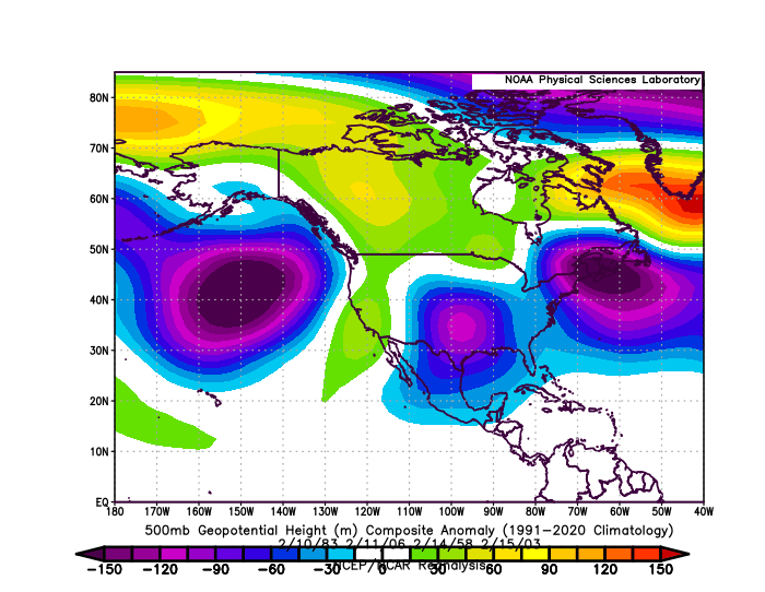
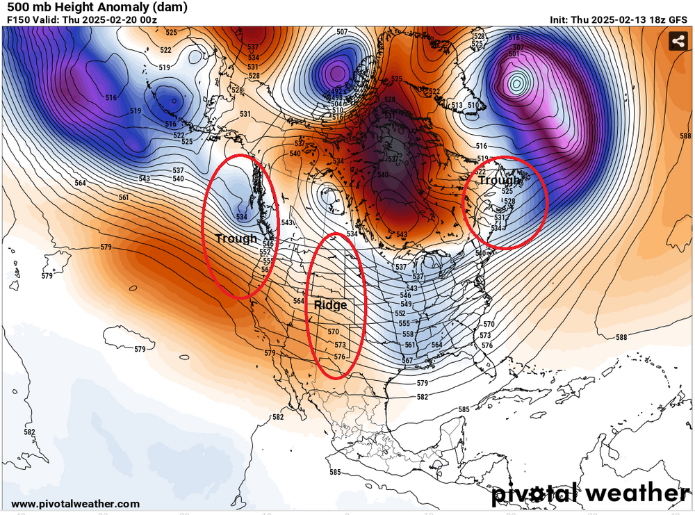
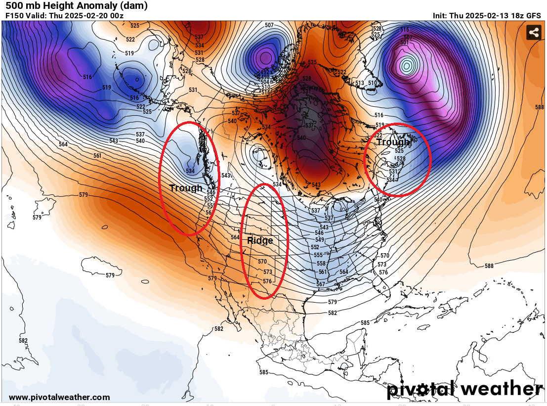
The 18z GFS had a largely suppressed solution. It showed a big snowfall in southeastern Virginia. I've taken the 500 mb map and identified where the features have typically been for blockbuster February snowstorms that occurred after February 7th and the cluster for such snowstorms during the second half of February. Details make a difference. If the ridging is on or off the Pacific Northwest at this time of year, one will be more likely than not to see a suppressed solution. The suppressed solution is consistent with the 500 mb pattern that operational GFS is forecasting. Fortunately, as this is an operational run at a 6-7 day timeframe, there remains considerable room for changes. Blockbuster February snowstorms for NYC (February 8-29):