donsutherland1
-
Posts
24,197 -
Joined
Content Type
Profiles
Blogs
Forums
American Weather
Media Demo
Store
Gallery
Everything posted by donsutherland1
-
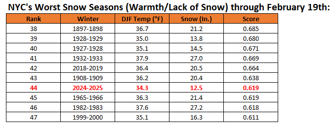
I will post the final rankings at the end of the season. Here's where things stood as of yesterday: 2024-2025 was marginally worse than 1965-1966. 2024-2025 was the worst ranked winter with a mean temperature to date of 34.3° or below.
-
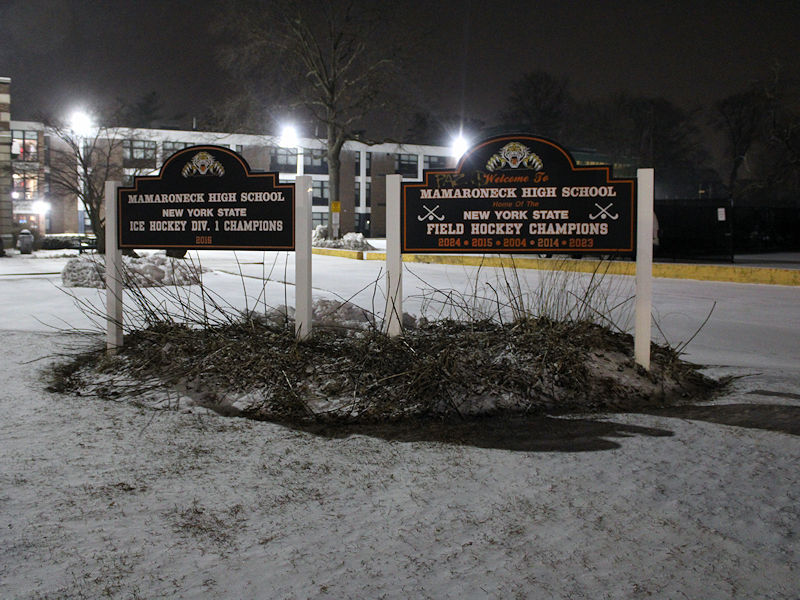
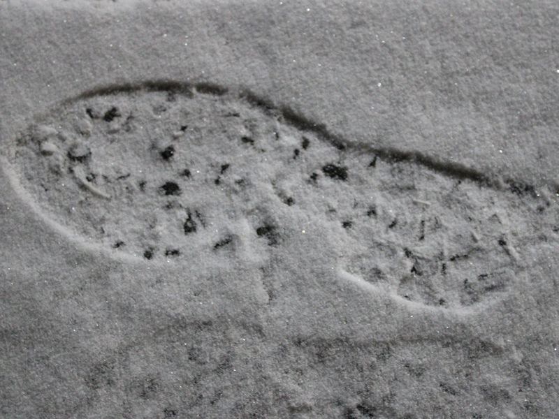
Two photos from Mamaroneck. Light snow continues to fall, but there's not much fluff to the snow and it is barely accumulating.
-
I fully expect that Central Park will record measurable snow when the final report is posted. In the Bronx, there was a solid coating of snow this evening. Earlier, there seemed to be a similar coating based on the Columbus Circle webcam.
-
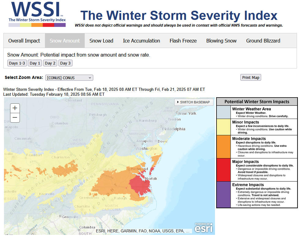
A storm passing well south and east of New York City produced a significant snowfall in parts of the lower Middle Atlantic region yesterday into today. Some 12" or above amounts were recorded in the the Portsmouth and Virginia Beach areas, as well as parts of North Carolina. 1 SSE Macons Corner, VA picked up 13.0" of snow. 2 NNW Currituck, NC received 14.0" of snow. Snowfall amounts included: Norfolk: 11.0" Raleigh: 2.6" Richmond: 4.0" Washington, DC: 0.1" Norfolk has now received 16.8" of snow this winter. That makes Winter 2024-2025 its snowiest winter since Winter 2010-2011 when 21.2" fell. A period of light snow or flurries from the associated upper low will bring a coating to 0.5" of snow in and around New York City. Somewhat higher amounts are possible from central New Jersey southward and across eastern Suffolk County. It will turn milder late in the weekend and the milder weather will continue next week. There remain indications that a major pattern re-alignment could take place starting in the first week of March. The ENSO Region 1+2 anomaly was +0.9°C and the Region 3.4 anomaly was -0.3°C for the week centered around February 12. For the past six weeks, the ENSO Region 1+2 anomaly has averaged +0.03°C and the ENSO Region 3.4 anomaly has averaged -0.65°C. La Niña conditions have peaked and are beginning to fade. La Niña conditions will likely persist into the start of spring. The SOI was -11.77 yesterday. The preliminary Arctic Oscillation (AO) was -0.414 today. Based on sensitivity analysis applied to the latest guidance, there is an implied 94% probability that New York City will have a colder than normal February (1991-2020 normal). February will likely finish with a mean temperature near 33.6° (2.3° below normal).
-
As per mPING, there is some snow falling in the Lehigh Valley. It's not all virga.
-
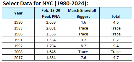
Today, the preliminary PNA value is +1.663. Since 1980, there have been seven years where the PNA reached +1.500 or above during the February 15-29 period. Those cases did not feature any major snowstorms during March. Moreover, during the second half of February, strongly positive PNA regimes do not favor major snowstorms. Indeed, New York City received no 10" or greater snowstorms when the PNA was +1.000 or above during the second half of February through the remainder of the snow season (1950-2024). All said, given the lack of model support for its solution and the historic data concerning strongly positive PNA events at this time of year, the 2/20 12z GGEM solution is very unlikely to verify. This does not mean that there can't be any snowfall for the remainder of this month or during March. It just means that major events are unlikely. There were some significant snowfalls (6"+), so that might be about the top end of what could reasonably be expected. As always, sample size considerations and the low probability of an exceptional event can't be ruled out. But unless there is strong and consistent evidence for such an event, one should be skeptical about outlier model solutions such as that which was shown on this morning's GGEM run.
-
It happened even sooner than I could respond.
-
So far, Bayside, VA has seen 8.0" of snow.
-
A storm passing well south and east of New York City will bring a significant snowfall to parts of the lower Middle Atlantic region tonight into tomorrow. Snowfall estimates: Norfolk: 6"-12" Raleigh: 1"-3" Richmond: 3"-6" A period of light snow or flurries is still possible in the New York City area from the associated upper-level low. The light snow event could bring a coating to a half-inch of snow. Somewhat higher amounts are possible from central New Jersey southward and across eastern Suffolk County. Overall, generally colder outcome is likely during the second half of February. Precipitation will likely be near or somewhat above normal. However, there are growing indications for a major pattern shift during the first week of March. Some of the guidance begins to break down the pattern in the closing days of February. The CFSv2 is currently a cold outlier. The ENSO Region 1+2 anomaly was +0.9°C and the Region 3.4 anomaly was -0.3°C for the week centered around February 12. For the past six weeks, the ENSO Region 1+2 anomaly has averaged +0.03°C and the ENSO Region 3.4 anomaly has averaged -0.65°C. La Niña conditions have peaked and are beginning to fade. La Niña conditions will likely persist into the start of spring. The SOI was -16.91 yesterday. The preliminary Arctic Oscillation (AO) was -2.306 today. Based on sensitivity analysis applied to the latest guidance, there is an implied 92% probability that New York City will have a colder than normal February (1991-2020 normal). February will likely finish with a mean temperature near 33.4° (2.5° below normal).
-
A very cold air mass covers the East. The temperature could fall into the teens tomorrow morning from Baltimore northward into New England. The cold will likely persist through the remainder of the week. Conditions will moderate during the weekend. A storm passing well south and east of New York City will bring a significant snowfall to parts of the lower Middle Atlantic region tomorrow into Thursday. The forecast 500 mb pattern for eastern North America has some similarities to January 29-31, 2010 but is even more suppressed. A period of light snow or flurries is still possible in the New York City area from the associated upper-level low. The light snow event could bring a coating to a half-inch of snow. Somewhat higher amounts are possible from central New Jersey southward and across eastern Suffolk County. The models continue to show 8" or more snow in Norfolk. The last time Norfolk saw 8" or more snow from a storm was January 3-4, 2018 when 10.3" fell. Since 1895, there were 17 storms that brought 8" or more snow to Norfolk. The breakdown for NYC snowfall was: 6" or more: 18%; Less than 1": 76%; No measurable snowfall: 53%; No snowfall: 41%. Currently, the PNA is above +1.000. In January and the first half of February, a strongly positive PNA would be conducive toward facilitating patterns favorable for potentially major snowfalls in the New York City area. During the second half of February, such a strong PNA works against such snowstorms due to the shorter wave lengths. The storm this week will be no exception. Overall, generally colder outcome is likely during the second half of February. Precipitation will likely be near or somewhat above normal. However, there are growing indications for a major pattern shift during the first week of March. Some of the guidance begins to break down the pattern in the closing days of February. The CFSv2 is currently a cold outlier. The ENSO Region 1+2 anomaly was +0.9°C and the Region 3.4 anomaly was -0.3°C for the week centered around February 12. For the past six weeks, the ENSO Region 1+2 anomaly has averaged +0.03°C and the ENSO Region 3.4 anomaly has averaged -0.65°C. La Niña conditions have peaked and are beginning to fade. La Niña conditions will likely persist into the start of spring. The SOI was -16.91 today. The preliminary Arctic Oscillation (AO) was -3.917 today. Based on sensitivity analysis applied to the latest guidance, there is an implied 91% probability that New York City will have a colder than normal February (1991-2020 normal). February will likely finish with a mean temperature near 33.2° (2.7° below normal).
-
Great post, Bluewave. I agree with you about non-linear effects. Jennifer Francis has highlighted the connection between a warming Arctic and downstream impacts in the mid-latitudes. The quantification of the share of climate change vs. internal variability on specific patterns isn't yet as robust as other areas in attribution science. The existence of quasi-resonant amplification (QRA) has also contributed to long-duration patterns (one saw this in some of the recent persistent heat in Mexico/SW U.S. from the late spring into the fall). My reference about slightly colder than it would otherwise have been refers to the magnitude of cold given the pattern that prevailed. Now, if the pattern would not have prevailed absent climate change, then there's a larger impact. I reserve judgment on that until attribution improves. It is plausible and perhaps likely that there's a larger impact. Changes in extreme temperatures are larger than changes in means. That's why I am confident that NYC would have easily been in the single digits in January were it not for climate change. It's why Baton Rouge and Phoenix had months that were hotter, by far, than anything that would have been expected given just linear warming. On seasonal snowfall, I believe climate change is playing a role, as well and that NYC is in the early stages of a structural decline in snowfall. Internal variability is noisy, but it should be clear by the mid-2030s. Already, one has seen such declines in seasonal snowfall in such cities as Richmond and Washington. The marine heatwave-driven changes in the MJO, Pacific Jet, and warmer temperatures overall are all mechanisms by which climate change may be driving the structural decline in seasonal snowfall. I believe these mechanisms, and others, are topics of active research, but worry that the research could be disrupted or terminated in the current political environment. Have a great evening.
-
I believe Walt referenced 1"-2" of powder this morning. I'm not dismissing such a scenario. That's probably the top of what the NYC area might see absent an IVT. I'm thinking coating to a half-inch at Central Park, but we'll see. The general 3"+ snowfall on the NAM is what I don't think will verify.
-
If an IVT forms, it would provide a localized snow event. Most of the NYC area would not likely benefit. The GGEM has a more prominent IVT signal than the GFS, but we'll have to see whether later guidance shows it and, if so, where it forms. The NAM had far more than a Norlun trough. It tracked the storm north and west of the other guidance producing a larger snowfall across the region. Its current idea of the pattern is an outlier. The 12z GGEM has reaffirmed the other guidance. We'll see what the UKMET and ECMWF show a little later. But I think at this time, one can have good confidence that the NAM's scenario is a low probability one.
-
The 12z 12 km NAM is an outlier. The 3 km version, along with the RGEM and GFS remain in good agreement with the storm's focus. Flurries or a period of light snow remain possible in the New York City area and surrounding region (probably 0.5" or less in NYC). But the 3"+ amount shown on the 12km NAM is very unlikely given that the model is on its own with a track to the north and west of the other guidance.
-
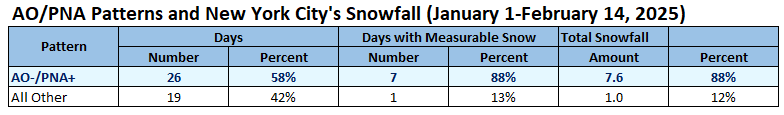
While climate change, particularly through marine heatwaves, likely played a role in shaping the overall hemispheric pattern and contributed to pattern persistence, the pattern specifics likely drove the January outcome and February outcome to date. Pattern specifics are a function of internal variability within the context of a warming climate. Climate change likely made this winter somewhat warmer than it might otherwise have been, but that likely had only a marginal impact on the snowfall. Absent climate change, New York City would likely have seen its coldest temperature reach the single digits rather than 10°. Despite a favorable AO-/PNA+ combination mainly during the first three weeks of January, opportunities for big snowfalls in New York City did not materialize. One issue was that the AO became too severely negative leading to suppression. There was above normal snowfall, but it was focused on such cities as Baltimore, Richmond, and Washington, D.C. As noted on 1/1: Should the AO dive below -3.000, which now appears likely, the prospects for a significant or major snowfall in the New York City area could be reduced. The AO plunged to -3.795 on January 5th. The storm was suppressed with Baltimore and Washington, DC seeing 6" or more snow, but just 0.9" in New York City. The window of opportunity for a big snowstorm closed after January 20th as a positive AO regime took hold. That regime continued through February 7th. Such regimes typically favor smaller than blockbuster snowfalls in January. The AO has since gone negative. However, that coincided with a positive PNA. An AO-/PNA+ regime is conducive to significant snowfalls during January and the first half of February (higher than climatological probability). However, once one gets into the second half of February, the PNA+ often leads to suppression in an environment characterized by shorter wave lengths. On 2/13, I responded to the 18z GFS's forecast pattern that "If the ridging is on or off the Pacific Northwest at this time of year, one will be more likely than not to see a suppressed solution." The storm tomorrow into Thursday will be suppressed. Norfolk remains in line for a 6"-10" snowfall. At best, New York City could see some flurries or a period of light snow, but a no snow outcome is on the table. In general, patterns provide insight into potential for a broad area e.g., the Middle Atlantic region. They do not provide details for specific locations within the region. Synoptic details determine whether the potential is realized and how specific locations are impacted. Patterns can provide insight into the medium range (often 4-7 days); synoptic details provide useful information within 3 days or less based on operational model skill. In fact, the presence of the AO-/PNA+ pattern accounted for a disproportionate share of days with measurable snowfall and total snowfall during the January 1-February 14 period as suggested by the climate record: Overall, pattern flaws and stochastic synoptic details played the largest role in shaping Winter 2024-2025's snowfall in the New York City area so far this season. Finally, in terms of longer-term snowfall averages, I suspect that the combination of climate change and internal variability are responsible for the recent decline with NYC perhaps in the very early stages of a structural decline in seasonal snowfall (I don't believe the area running from Boston to Caribou is currently experiencing any long-term decline in seasonal snowfall; gains in moisture as winters warm may actually be leading to an increase at Caribou right now). By the mid-2030s, the impact of climate change should be more evident with New York City's 30-year average snowfall falling to or perhaps somewhat below 20". Even then, there will still be periodic snowy winters and big snowstorms for decades to come.
-
With respect to the NBM, one should note that snowfall forecasts at the fringes of storms are likely overdone. In extreme cases, measurable snowfall is forecast even when qpf is 0. That issue won't be fixed until Version 5 is released.
-
Final outcome: Warmer than had been modeled.

-
A much colder air mass has moved into the region on strong winds. The temperature could fall into the teens on tomorrow morning and/or Wednesday morning from Baltimore northward into New England. The cold will likely persist through the remainder of the week. Conditions will moderate during the weekend. A storm will likely bring a significant snowfall to parts of the lower Middle Atlantic region. The forecast 500 mb pattern for eastern North America has some similarities to January 29-31, 2010 but is even more suppressed. A period of light snow or flurries is still possible in the New York City area, but such an outcome is not assured. The models generally show 8" or more snow in Norfolk, but some of the guidance has shifted even farther south and east. Since 1895, there were 17 storms that brought 8" or more snow to Norfolk. The breakdown for NYC snowfall was: 6" or more: 18%; Less than 1": 76%; No measurable snowfall: 53%; No snowfall: 41%. Currently, the PNA is above +1.000. In January and the first half of February, that would be conducive toward facilitating patterns favorable for potentially major snowfalls in the New York City area. During the second half of February, such a strong PNA works against such snowstorms due to the shorter wave lengths. The storm this week will be no exception. Overall, generally colder outcome is likely during the second half of February. Precipitation will likely be near or somewhat above normal. However, there are growing indications for a major pattern shift during the first week of March. Some of the guidance begins to break down the pattern in the closing days of February. The CFSv2 is currently a cold outlier. The ENSO Region 1+2 anomaly was +0.9°C and the Region 3.4 anomaly was -0.3°C for the week centered around February 12. For the past six weeks, the ENSO Region 1+2 anomaly has averaged +0.03°C and the ENSO Region 3.4 anomaly has averaged -0.65°C. La Niña conditions have peaked and are beginning to fade. La Niña conditions will likely persist into the start of spring. The SOI was -12.39 today. The preliminary Arctic Oscillation (AO) was -4.896 today. Based on sensitivity analysis applied to the latest guidance, there is an implied 92% probability that New York City will have a colder than normal February (1991-2020 normal). February will likely finish with a mean temperature near 33.0° (2.9° below normal).
-
While many mourn what might have been as yet another snowstorm is forecast to push far to our south and east, as a reminder that spring isn't far off, the New York Botanical Garden's annual orchid show has opened.


-
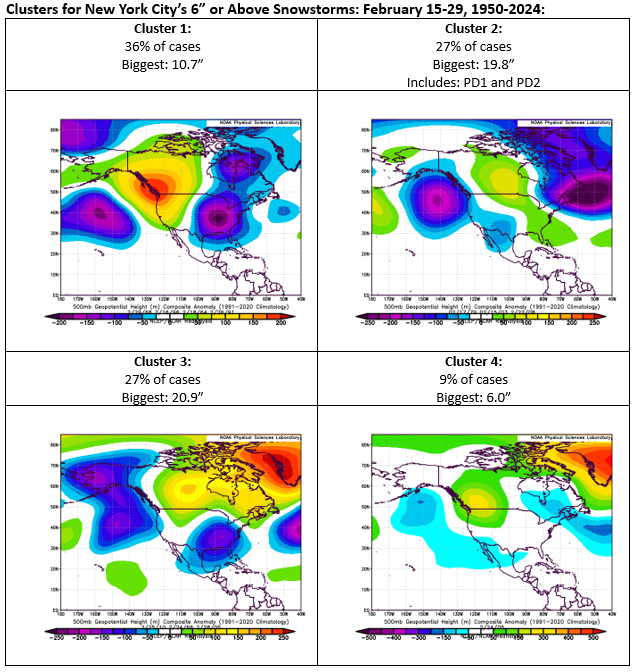
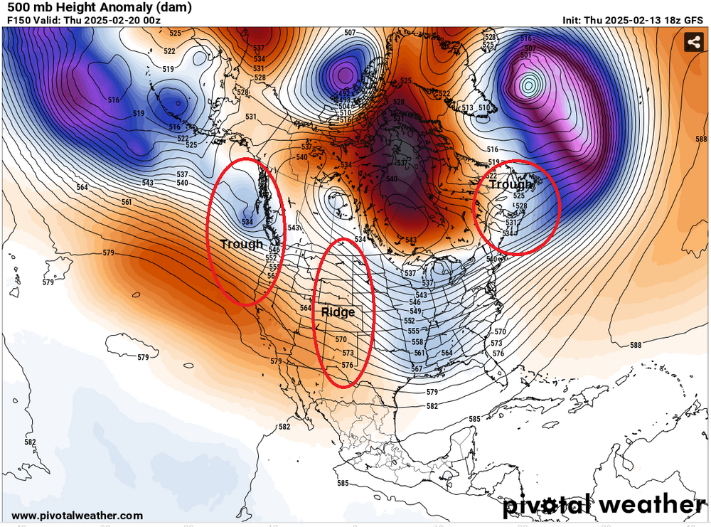
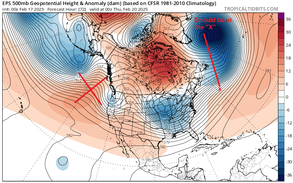
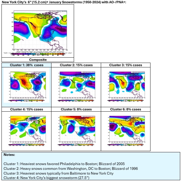
Back on Thursday, the flaws in the 500 mb pattern were showing up on some of the guidance e.g., the GFS. At the time, I noted: The 18z GFS had a largely suppressed solution. It showed a big snowfall in southeastern Virginia. I've taken the 500 mb map and identified where the features have typically been for blockbuster February snowstorms that occurred after February 7th and the cluster for such snowstorms during the second half of February. Details make a difference. If the ridging is on or off the Pacific Northwest at this time of year, one will be more likely than not to see a suppressed solution. Unfortunately, the 500 mb pattern has only deteriorated further. Below is the 2/17 0z EPS output: The EPS pattern is remarkably similar to the GFS forecast from last Thursday. At that time, the GFS was in a distinct minority of models indicating a suppressed solution. In January, with its longer wave lengths, ridging off the Pacific Northwest and into the Gulf of Alaska can facilitate storm tracks for significant or major snowfalls. But in the second half of February, with its shorter wave lengths, one gets suppressed solutions, as appears poised to play out. Below are the 6" or greater snowstorm clusters for the second half of February (Clusters 2 and 3 are the ones with the KU storms): In comparison, here are clusters for January for the dominant patterns for significant (6" or above) snowstorms: There still remains a degree of uncertainty. That uncertainty could be the difference between a period of light snow/flurries or no snowfall whatsoever in the New York City area. At this time, the guidance has moved into a skillful range for synoptic features, so barring unexpected and unusual developments, any changes will likely be modest. The overall point is that time of season matters. A pattern that might work very well in mid-winter e.g., January, isn't necessarily a great pattern near the end of winter (second half of February).
-
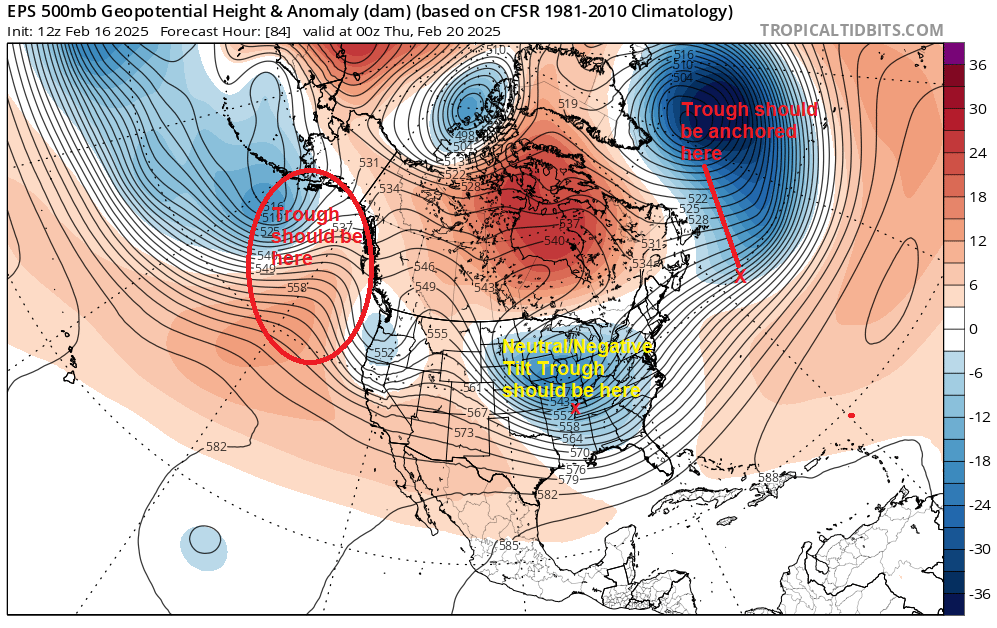
The EPS has diverged even farther from the clusters for second-half February 6" or above snowstorms in New York City. The combination of differences in key features and a positively-tilted trough in the Ohio Valley favors an out-to-sea track well south of the region. Things can still change somewhat in coming days to allow for some snow in the NYC area. However, a major snowstorm is now a low probability scenario. EPS compared to Cluster 3: Clusters:
-
I had a typo that was fixed subsequent to your reply. 18%, not 24%, were 6" or more in NYC.
-
It's too soon to be sure that this was the last snowfall opportunity for the remainder of the winter. Moreover, the pattern change is not yet cast in stone. It looks like early March is more favored than the end of February and there could still be some opportunities for snowfall.
-
The temperature will rise this evening until 7 pm - 9 pm. Afterward, it will begin to fall. Although JFK Airport has reached 52° this afternoon, the mild air has had difficulty pushing northward into Manhattan, northern Queens, and the Bronx. Through 4:30 pm, the high temperatures at Central Park and LaGuardia Airport have been 41°. The temperature at both locations could peak in the middle or even upper 40s, but it appears unlikely that they will reach 50°. In the wake of the storm, it will turn sharply colder tomorrow. Winds could also gust past 50 mph in parts of the area. Temperatures could fall into the teens on Tuesday and/or Wednesday morning from Baltimore northward into New England. The cold will likely persist through the remainder of the week. A storm could bring snow to parts of the East Coast after the middle of next week. The forecast 500 mb pattern for eastern North America has some similarities to January 29-31, 2010 but is even more suppressed. However, there remains a degree of uncertainty. By late tomorrow, the forecast accuracy of the synoptic details will become more skillful. In terms of the guidance, the 12z ECMWF, GGEM, and UKMET are in good agreement about the focus of the heaviest snows. Those models show 8" or more snow in Norfolk. Since 1895, there were 17 storms that brought 8" or more snow to Norfolk. The breakdown for NYC snowfall was: 6" or more: 18%; Less than 1": 76%; No measurable snowfall: 53%; No snowfall: 41%. Moreover, the three models showed less than 2" snow at Philadelphia. Using the Norfolk data, there were 11 cases in the subset that had less than 2" at Philadelphia. The New York City breakdown was: Less than 1": 100%; No measurable snowfall: 73%; No snowfall: 64%. Overall, generally colder outcome is likely during the second half of February. Precipitation will likely be near or somewhat above normal. However, there are growing indications for a major pattern shift during the first week of March. The ENSO Region 1+2 anomaly was +0.1°C and the Region 3.4 anomaly was -0.6°C for the week centered around February 5. For the past six weeks, the ENSO Region 1+2 anomaly has averaged -0.10°C and the ENSO Region 3.4 anomaly has averaged -0.72°C. La Niña conditions are underway and will likely persist into the start of spring. The SOI was -0.58 today. The preliminary Arctic Oscillation (AO) was -4.896 today. Based on sensitivity analysis applied to the latest guidance, there is an implied 92% probability that New York City will have a colder than normal February (1991-2020 normal). February will likely finish with a mean temperature near 32.7° (3.2° below normal).