donsutherland1
-
Posts
24,197 -
Joined
Content Type
Profiles
Blogs
Forums
American Weather
Media Demo
Store
Gallery
Everything posted by donsutherland1
-
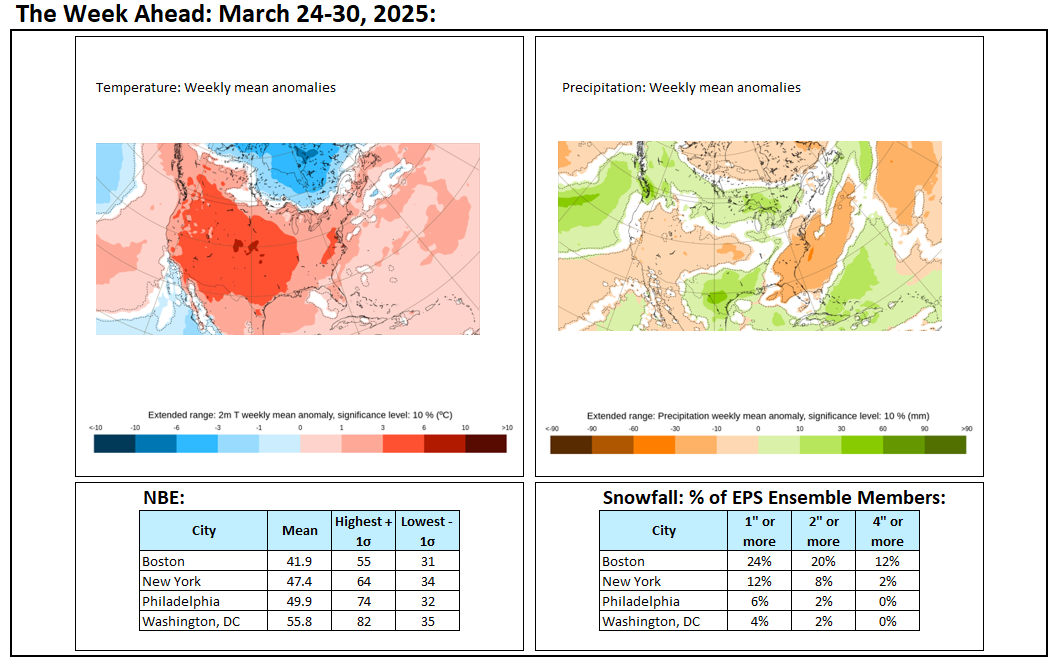
DCA _ NYC _ BOS __ ORD _ ATL _ IAH ___ DEN _ PHX _ SEA -0.2 -0.2 0.3 -0.4 1.3 1.3 0.7 1.0 0.4
-
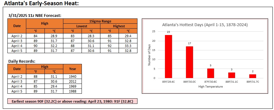
Before a return to cooler weather, Atlanta could experience a historic early-season heat event this week.
-
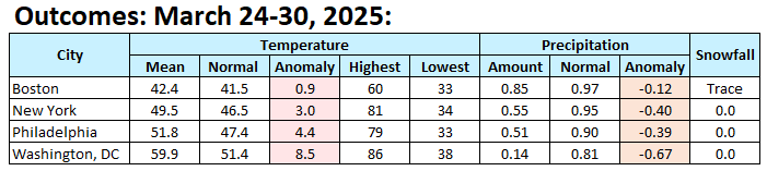
Final outcome: The period was warmer than had been shown on the guidance. The high temperatures well far higher than the values suggested on the guidance.
-
Temperatures will rebound tomorrow. It will be unseasonably warm with highs in the middle and upper 60s. A cold front will move slowly across the region tomorrow and tomorrow night. It could be accompanied by strong thunderstorms, damaging winds, and heavy rainfall. A general 0.50"-1.50" rainfall with locally higher amounts is possible from late tomorrow afternoon through Tuesday morning. The temperature roller coaster will again dip for Tuesday and Wednesday before unseasonable warmth returns on Thursday. An AI random forest model currently suggests that April could wind up near or even somewhat below normal in New York City. A random forest model is a machine learning algorithm that combines the output of multiple decision trees to handle non-linear relationships to reach a single result. The ENSO Region 1+2 anomaly was +0.9°C and the Region 3.4 anomaly was -0.1°C for the week centered around March 19. For the past six weeks, the ENSO Region 1+2 anomaly has averaged +1.00°C and the ENSO Region 3.4 anomaly has averaged -0.18°C. Neutral ENSO conditions will likely continue into at least late spring. The SOI was +2.54 today. The preliminary Arctic Oscillation (AO) was +1.260 today. Based on sensitivity analysis applied to the latest guidance, there is an implied near 100% probability that New York City will have a warmer than normal March (1991-2020 normal). March will likely finish with a mean temperature near 46.9° (4.2° above normal). That would tie March 1979 as the 11th warmest March on record.
-
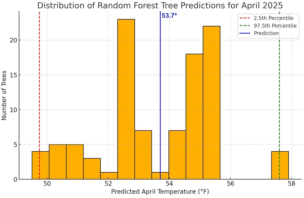
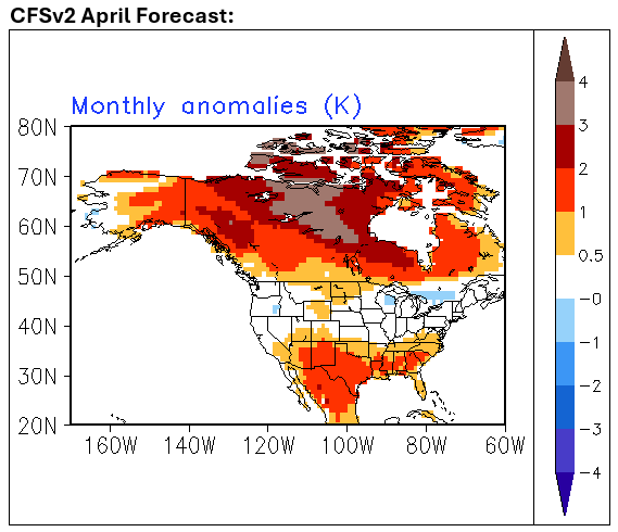
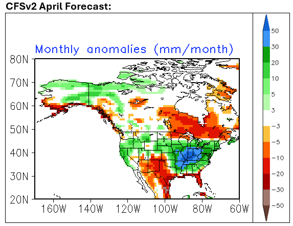
Artificial Intelligence (AI) has garnered significant attention this winter and early spring in forecasting. Multiple AI initiatives are ongoing. In some cases, such as forecast 500 mb patterns, AI has shown improvement over the best-of-class operational ECMWF model. One area that has not garnered as much attention is longer-range forecasting. Can AI make advances that push the frontiers of long-range forecasting? Chaos and non-linearity become more important as one expands the forecasting timeframe. To take a closer look, I constructed some AI models to forecast the coming April. The AI-generated standard error and coefficient of determination hint at a large improvement over linear forecasting techniques. I say "hint," because I remain cautious about a hindcasting problem where things look good against past data only to break down in an actual forecasting situation. Consider, for example, the initial promise and more limited impact of using the Siberian Snow Advance Index (SAI) for winter forecasting. I will share the results here for New York City (Central Park). April 2025 AI Forecast: Monthly mean temperature: 53.7° Monthly maximum temperature: 84° Monthly minimum temperature: 35° Monthly precipitation: 4.32" Those are equivalent to ensemble means. Some additional information: Monthly mean temperature: Below 52°: 17% trees or members Below 53°: 41% of members 54° or above: 51% of members 55° or above: 28% of members 56° or above: 4% of members This indicates that although somewhat more members show an above normal temperature, the smaller number of cool members are sufficiently cool to skew the overall average. Monthly precipitation: Below 3": 25% 4" or above: 61% 5" or above: 21% Monthly Snowfall: No measurable snowfall: 86% of members Trace of snow: 13% of members Measurable snow: 1% of members I also inquired about how many members showed an April freeze. 29% had a monthly minimum temperature of 32° or below. 1991-2020 Baselines: Monthly Mean: 53.7° Monthly Maximum: 83° Monthly Minimum: 33° Monthly Precipitation: 4.09" Monthly Snowfall: 0.4" Comparison: CFSv2 Forecasts: Miscellaneous: The AI model suggested that both Phoenix (above normal on the CFSv2) and Boston (normal on the CFSv2) would be above normal with April mean temperatures of 74.1° and 49.4° respectively. The AI model also suggested that Phoenix would have an April monthly maximum of 100° (range of scenarios: 97°-105° with 47% of members at 100° or above). Phoenix's monthly minimum is forecast at 51°. In terms of rainfall, the mean forecast for Phoenix was 0.22" (normal). 33% of members showed no measurable rainfall; 67% had measurable rainfall; 28% had 0.25" or more; 13% had 0.50" or more; and, 8% had 1.00" or more. My expectation: I am agnostic about the AI forecasts. Aside from my own thinking that an April freeze is unlikely and that NYC has very likely seen its last measurable snowfall, I have no strong views about the possible outcomes. I note that this time around, the AI forecasts seem to be broadly in line with the CFSv2 ideas. Outcome: The outcome will be verified at the end of the month.
-
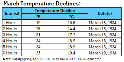
White Plains has now seen the temperature fall 41F (22.8C) from its daily high. That breaks the March record of 40F (22.2C) set on March 4, 1972.
-
I revised my thinking to mid 50s for tomorrow.
-
So far, Central Park has seen its largest one- and two-hour drops on record for March: 26 degrees and 29 degrees respectively.
-
The temperature surged into the 80s in parts of the region today. New York City saw its first 80° or above March temperature since March 26, 2021 when the thermometer peaked at 82°. March 29th, which accounts for 5 of New York City's 17 80° or above March temperatures, is the most common date for such temperatures in March. High temperatures included: Islip: 82° (old record: 81°, 1998) ***Tied March monthly record*** New York City-Central Park: 81° New York city-JFK Airport: 81° New York City-LaGuardia Airport: 82° Newark: 85° White Plains: 80° So far, the high temperature at Burlington is 31°. If Burlington's high temperature finishes at 32° or below, today would be the first time on record that Burlington had a high of 32° or below when New York City had a high of 80° or above. Currently, the coldest high at Burlington when New York City reached 80° or above is 33°. That occurred on April 7, 1942 when New York City had a maximum temperature of 82°. Tomorrow will be noticeably cooler with highs in the middle to perhaps upper 50s in New York City, but Monday could be another unseasonably warm day with highs in the middle and upper 60s. The temperature roller coaster will again dip for Tuesday and Wednesday before unseasonable warmth returns on Thursday. An AI random forest model currently suggests that April could wind up near or even somewhat below normal in New York City. A random forest model is a machine learning algorithm that combines the output of multiple decision trees to handle non-linear relationships to reach a single result. The ENSO Region 1+2 anomaly was +0.9°C and the Region 3.4 anomaly was -0.1°C for the week centered around March 19. For the past six weeks, the ENSO Region 1+2 anomaly has averaged +1.00°C and the ENSO Region 3.4 anomaly has averaged -0.18°C. Neutral ENSO conditions will likely continue into at least late spring. The SOI was +16.94 yesterday. The preliminary Arctic Oscillation (AO) was +1.694 today. Based on sensitivity analysis applied to the latest guidance, there is an implied near 100% probability that New York City will have a warmer than normal March (1991-2020 normal). March will likely finish with a mean temperature near 47.2° (4.4° above normal). That would tie March 2000 as the 10th warmest March on record.
-
The temperature has dropped from 75F (23.9C) to 59F (15.0C) between 4:05 pm and 4:15 pm EDT in White Plains, as the backdoor cold front slices into the suburbs of New York City.
-
The temperature has dropped from 75F 23.9C) to 66F (18.9C) between 4:05 pm and 4:10 pm EDT in White Plains, as the backdoor cold front slices into the suburbs of New York City.
-
Islip tied its March monthly mark of 82°. That record was set on March 13, 1990.
-
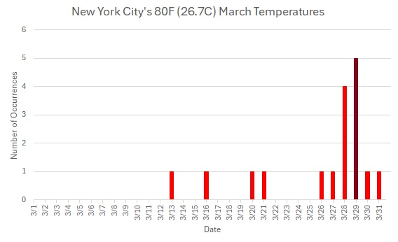
New York City has reached 81F (27.2C). Today is just the 17th March day on record with an 80F (26.7C) or above reading on record since 1869. March 29th has seen 5 such readings. March 28th has seen 4. Every other day with such a reading has seen only 1 such occurrence.
-
Islip has now reached 80°. That is only the third such temperature on record and the third highest such reading on record for March. Islip's Highest March Readings: 82°, March 13, 1990 81°, March 29, 1998 80°, March 29, 2025* *-Could rise further
-
78 at Central Park.
-
Arctic.
-
The temperature could fall 20°-25° over a 3-6-hour period later today in New York City. For comparison, below are the records for one-hour through six-hour drops in March:
-
It may be overdone. I believe the 12z GFS was overdone on the warm side for Sunday. We'll see where things have converged tomorrow.
-
I'm talking about NYC. North of the City it will be noticeably cooler e.g., low 50s in White Plains.
-
Tomorrow will see the warmest readings so far this spring in and around the New York City area. Highs could rise well into the 70s in the New York City area. Parts of New Jersey could see the mercury reach or exceed 80°. Baltimore and Washington, DC will likely see temperatures peak in the middle 80s. Sunday will be cooler with highs in the upper 50s, but Monday could be another unseasonably warm day with highs in the middle and upper 60s. The ENSO Region 1+2 anomaly was +0.9°C and the Region 3.4 anomaly was -0.1°C for the week centered around March 19. For the past six weeks, the ENSO Region 1+2 anomaly has averaged +1.00°C and the ENSO Region 3.4 anomaly has averaged -0.18°C. Neutral ENSO conditions will likely continue into at least late spring. The SOI was +13.64 yesterday. The preliminary Arctic Oscillation (AO) was +1.637 today. Based on sensitivity analysis applied to the latest guidance, there is an implied near 100% probability that New York City will have a warmer than normal March (1991-2020 normal). March will likely finish with a mean temperature near 47.1° (4.3° above normal). That would rank as the 11th warmest March on record.
-
Almost certainly, we are.
-
Number 10 is 47.2°.
-
With a preliminary low temperature of 34° in Central Park, it increasingly appears that the last freeze of the 2024-2025 season will have occurred on March 23rd. Milder air will return tomorrow and remain largely in place for the remainder of March. Saturday could see the warmest readings so far this spring in and around the New York City area. Highs could rise well into the 70s in the New York City area. Parts of New Jersey could see the mercury reach or exceed 80°. Sunday will be cooler with highs in the upper 50s, but Monday could be another unseasonably warm day with highs in the middle and upper 60s. The ENSO Region 1+2 anomaly was +0.9°C and the Region 3.4 anomaly was -0.1°C for the week centered around March 19. For the past six weeks, the ENSO Region 1+2 anomaly has averaged +1.00°C and the ENSO Region 3.4 anomaly has averaged -0.18°C. Neutral ENSO conditions will likely continue into at least late spring. The SOI was +9.72 yesterday. The preliminary Arctic Oscillation (AO) was +1.478 today. Based on sensitivity analysis applied to the latest guidance, there is an implied near 100% probability that New York City will have a warmer than normal March (1991-2020 normal). March will likely finish with a mean temperature near 47.0° (4.2° above normal). That would rank as the 11th warmest March on record.
-
May 9, 1977 also saw snow fall in NYC (trace) with accumulating snow in parts of NY and New England.
-
Tomorrow will be another cool day. Milder air will then return on Friday and remain largely in place for the remainder of March. Saturday could see the warmest readings so far this spring in and around the New York City area. Highs could rise well into the 70s in the New York City area. Sunday will be cooler with highs in the upper 50s, but Monday could be another unseasonably warm day with highs in the middle and upper 60s. The ENSO Region 1+2 anomaly was +0.9°C and the Region 3.4 anomaly was -0.1°C for the week centered around March 19. For the past six weeks, the ENSO Region 1+2 anomaly has averaged +1.00°C and the ENSO Region 3.4 anomaly has averaged -0.18°C. Neutral ENSO conditions will likely continue into at least late spring. The SOI was +10.05 yesterday. The preliminary Arctic Oscillation (AO) was +1.073 today. Based on sensitivity analysis applied to the latest guidance, there is an implied near 100% probability that New York City will have a warmer than normal March (1991-2020 normal). March will likely finish with a mean temperature near 46.7° (3.9° above normal). That would tie March 1977 for the 12th warmest March on record.