donsutherland1
-
Posts
24,197 -
Joined
Content Type
Profiles
Blogs
Forums
American Weather
Media Demo
Store
Gallery
Everything posted by donsutherland1
-
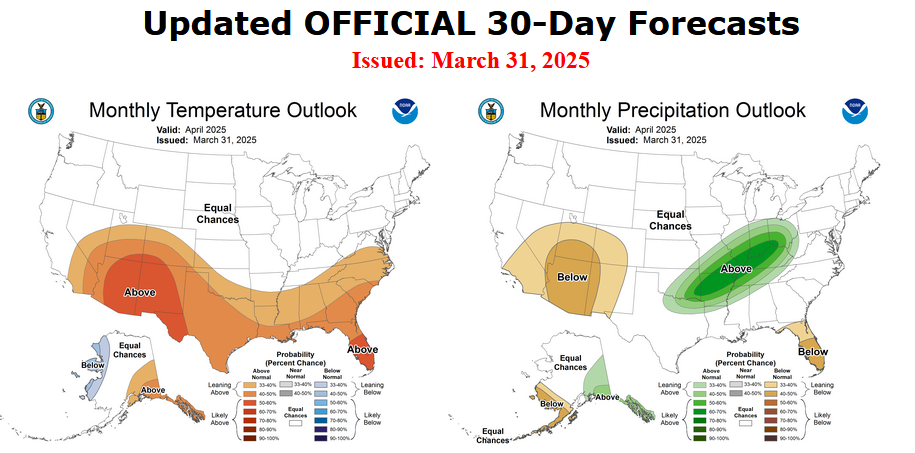
A cold rain will develop this evening or early tonight and continue into tomorrow. A general 0.50"-1.50" of rain is likely. Temperatures will top out in the lower and middle 40s in New York City area tomorrow. Some sleet pellets are possible outside New York City. Across parts of Central New York State and central New England, wet snow is possible. An appreciable snowfall is possible in higher elevations. Where areas remain above freezing, snowfall amounts will be limited. The temperature could approach seasonable levels on Sunday and then briefly go above normal early next week. However, before the warmth could become established, another surge of cooler air will push into the region by the middle of next week. The ENSO Region 1+2 anomaly was +1.3°C and the Region 3.4 anomaly was -0.1°C for the week centered around April 2. For the past six weeks, the ENSO Region 1+2 anomaly has averaged +1.23°C and the ENSO Region 3.4 anomaly has averaged +0.17°C. Neutral ENSO conditions will likely continue through at least late spring. Early indications are that summer 2025 will be warmer than normal in the New York City and Philadelphia areas. The potential exists for a much warmer than normal summer (more than 1° above normal). The SOI was +25.81 today. The preliminary Arctic Oscillation (AO) was +2.151 today. Based on sensitivity analysis applied to the latest guidance, there is an implied 68% probability that New York City will have a cooler than normal April (1991-2020 normal). April will likely finish with a mean temperature near 52.5° (1.2° below normal).
-
The pattern led to a stalled front. Thunderstorms developed and trained along that front for days, producing extreme rainfall in parts of the Tennessee Valley.
-
Very beautiful. They'll get more tonight.
-
Northeastern Canada is running colder than normal. Some of that cold air is draining into the Northeast. The AO has less influence now, as wave lengths are shorter.
-
Tonight will be cloudy, breezy, and cool. Some showers are likely. A few distant northern and western suburbs could even see a little snow or sleet. The week will end on a chilly note. A steady rain will develop tomorrow and continue through Saturday. A general 0.50"-1.50" of rain is likely. Temperatures will top out in the 40s in New York City. The temperature could approach seasonable levels by the end of the weekend and then briefly go above normal early next week. However, before the warmth could become established, another surge of cooler air will push into the region by the middle of next week. The ENSO Region 1+2 anomaly was +1.3°C and the Region 3.4 anomaly was -0.1°C for the week centered around April 2. For the past six weeks, the ENSO Region 1+2 anomaly has averaged +1.23°C and the ENSO Region 3.4 anomaly has averaged +0.17°C. Neutral ENSO conditions will likely continue through at least late spring. Early indications are that summer 2025 will be warmer than normal in the New York City and Philadelphia areas. The potential exists for a much warmer than normal summer (more than 1° above normal). The SOI was -6.85 yesterday. The preliminary Arctic Oscillation (AO) was +1.061 today. Based on sensitivity analysis applied to the latest guidance, there is an implied 68% probability that New York City will have a cooler than normal April (1991-2020 normal). April will likely finish with a mean temperature near 52.6° (1.1° below normal).
-
1.0".
-
It will begin to turn somewhat milder starting tomorrow, but temperatures will remain below seasonal norms. Temperatures could approach seasonable levels by the end of the weekend and it could briefly turn milder than normal early next week. In addition, a moderate to perhaps significant rainfall is likely from Friday through Saturday. The ENSO Region 1+2 anomaly was +1.3°C and the Region 3.4 anomaly was -0.1°C for the week centered around April 2. For the past six weeks, the ENSO Region 1+2 anomaly has averaged +1.23°C and the ENSO Region 3.4 anomaly has averaged +0.17°C. Neutral ENSO conditions will likely continue through at least late spring. Early indications are that summer 2025 will be warmer than normal in the New York City and Philadelphia areas. The potential exists for a much warmer than normal summer (more than 1° above normal). The SOI was +3.32 yesterday. The preliminary Arctic Oscillation (AO) was -0.103 today. Based on sensitivity analysis applied to the latest guidance, there is an implied 63% probability that New York City will have a cooler than normal April (1991-2020 normal). April will likely finish with a mean temperature near 53.0° (0.7° below normal).
-
JFK reached 32; LGA fell to 33; and, NYC dropped to 31.
-
Central Park reached 32 at 6 am.
-
Tomorrow will be another unseasonably cool day. High temperatures will top out in the upper 40s in New York City. The low temperature tomorrow morning could be near freezing in New York City and perhaps in the upper 20s outside the City. It will begin to turn somewhat milder after midweek with temperatures approaching near seasonable levels during the weekend. The ENSO Region 1+2 anomaly was +1.3°C and the Region 3.4 anomaly was -0.1°C for the week centered around April 2. For the past six weeks, the ENSO Region 1+2 anomaly has averaged +1.23°C and the ENSO Region 3.4 anomaly has averaged +0.17°C. Neutral ENSO conditions will likely continue through at least late spring. Early indications are that summer 2025 will be warmer than normal in the New York City and Philadelphia areas. The potential exists for a much warmer than normal summer (more than 1° above normal). The SOI was +13.84 yesterday. The preliminary Arctic Oscillation (AO) was -0.790 today. Based on sensitivity analysis applied to the latest guidance, there is an implied 60% probability that New York City will have a cooler than normal April (1991-2020 normal). April will likely finish with a mean temperature near 53.3° (0.4° below normal).
-
Tomorrow and Wednesday will be unseasonably cool days. High temperatures will likely remain confined to the 40s in New York City through Wednesday. The low temperature on Wednesday morning could be near freezing in New York City and perhaps in the upper 20s outside the City. It will begin to turn milder after midweek with temperatures approaching near seasonable levels. The ENSO Region 1+2 anomaly was +1.3°C and the Region 3.4 anomaly was -0.1°C for the week centered around April 2. For the past six weeks, the ENSO Region 1+2 anomaly has averaged +1.23°C and the ENSO Region 3.4 anomaly has averaged +0.17°C. Neutral ENSO conditions will likely continue through at least late spring. Early indications are that summer 2025 will be warmer than normal in the New York City and Philadelphia areas. The potential exists for a much warmer than normal summer (more than 1° above normal). The SOI was +6.78 today. The preliminary Arctic Oscillation (AO) was -0.776 today. Based on sensitivity analysis applied to the latest guidance, there is an implied 60% probability that New York City will have a cooler than normal April (1991-2020 normal). April will likely finish with a mean temperature near 53.5° (0.2° below normal).
-
New York State. Typo.
-
It will turn noticeably cooler tomorrow with some additional showers and light rain. Parts of New York State could even see some snow with a minor accumulation (0.5" or less) possible in Albany through tomorrow. High temperatures will likely remain confined to the 40s in New York City through Wednesday. It will begin to turn milder after midweek with temperatures approaching near seasonable levels. The ENSO Region 1+2 anomaly was +0.9°C and the Region 3.4 anomaly was -0.1°C for the week centered around March 19. For the past six weeks, the ENSO Region 1+2 anomaly has averaged +1.00°C and the ENSO Region 3.4 anomaly has averaged -0.18°C. Neutral ENSO conditions will likely continue into at least late spring. Early indications are that summer 2025 will be warmer than normal in the New York City and Philadelphia areas. The potential exists for a much warmer than normal summer (more than 1° above normal). The SOI was +6.78 today. The preliminary Arctic Oscillation (AO) was -0.852 today.
-
2025-2026 ENSO
donsutherland1 replied to 40/70 Benchmark's topic in Weather Forecasting and Discussion
Oceans have been warming from top down. I strongly doubt that his speculation has much merit. That we’re coming off an La Niña suggests that 2025 should be somewhat cooler than 2024 was overall, including SSTs. -
It will turn somewhat milder tomorrow with additional showers and thundershowers possible. Highs will likely reach the upper 50s in New York City and middle 60s in Philadelphia. It turn noticeably cooler on Monday with some additional showers. Much of next week could feature below normal temperatures. It will begin to turn milder after midweek with temperatures approaching near seasonable levels. The ENSO Region 1+2 anomaly was +0.9°C and the Region 3.4 anomaly was -0.1°C for the week centered around March 19. For the past six weeks, the ENSO Region 1+2 anomaly has averaged +1.00°C and the ENSO Region 3.4 anomaly has averaged -0.18°C. Neutral ENSO conditions will likely continue into at least late spring. Early indications are that summer 2025 will be warmer than normal in the New York City and Philadelphia areas. The potential exists for a much warmer than normal summer (more than 1° above normal). The SOI was +4.47 yesterday. The preliminary Arctic Oscillation (AO) was -0.484 today.
-
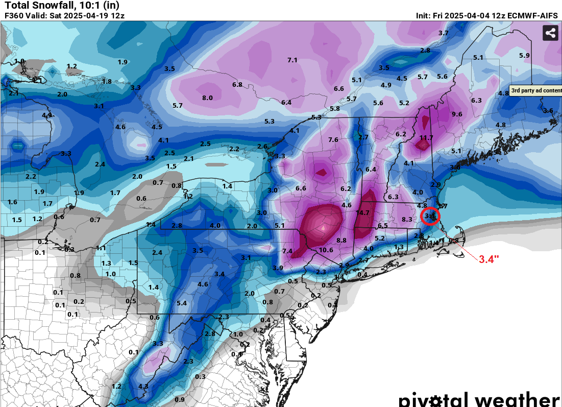
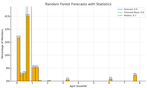
The ECMWF AIFS (4/3 12z) appears to be continuing to struggle with snowfall, very likely bringing the southern extent of measurable snowfall too far to the south. The 18z had 7.4" at Boston and none at New York City. Boston could see some measurable snowfall (probably <1"). When one runs an AI model, the numbers generated are consistent with a much lower snowfall than what the AIFS is showing: 77% of members from the above forecast are < 1" of snow. Just 5% of members are 3.4" or above (AIFS value). The trimmed mean is probably the best idea, as it excludes outliers that could skew the forecast average. New York City will likely see no measurable snowfall (AIFS: 1.4"), though there remains a possibility of a trace of snow. IMO, the AIFS is still learning. I expect far fewer "false alarms" next year.

-
Tomorrow will be unseasonably cool with some showers or periods fo rain. It will turn somewhat milder on Sunday with additional showers and thundershowers possible. Highs will likely reach the upper 50s in New York City and middle 60s in Philadelphia. It will turn cooler on Saturday and then milder again on Sunday. Showers are possible during the weekend. Much of next week could feature below normal temperatures. Two big stories continue to dominate the U.S. weather this week. First, a major to historic rainfall event is affecting parts of the Tennessee Valley. Excessive rainfall is occurring in parts of Arkansas, Kentucky, Missouri, and Tennessee. Second, unseasonable heat covers parts of the Southeast. Tampa could experience its earlest four-day heatwave on record during April 2-5. The existing record is April 26-29, 1991. The ENSO Region 1+2 anomaly was +0.9°C and the Region 3.4 anomaly was -0.1°C for the week centered around March 19. For the past six weeks, the ENSO Region 1+2 anomaly has averaged +1.00°C and the ENSO Region 3.4 anomaly has averaged -0.18°C. Neutral ENSO conditions will likely continue into at least late spring. Early indications are that summer 2025 will be warmer than normal in the New York City and Philadelphia areas. The potential exists for a much warmer than normal summer (more than 1° above normal). The SOI was +26.82 yesterday. The preliminary Arctic Oscillation (AO) was -0.043 today.
-
Tomorrow will remain warm, but showers and perhaps a thundershower are possible as a cold front moves through the region. It will turn cooler on Saturday and then milder again on Sunday. Showers are possible during the weekend.The first half of next week could feature below normal temperatures. Two big stories will likely dominate the U.S. weather this week. First, a major to historic rainfall event is likely to affect parts of the Tennessee Valley tomorrow through Sunday. Excessive rainfall is likely in parts of Arkansas, Kentucky, Missouri, and Tennessee. Second, unseasonable heat is likely in parts of the Southeast. Tampa could experience its earlest four-day heatwave on record during April 2-5. The existing record is April 26-29, 1991. The ENSO Region 1+2 anomaly was +0.9°C and the Region 3.4 anomaly was -0.1°C for the week centered around March 19. For the past six weeks, the ENSO Region 1+2 anomaly has averaged +1.00°C and the ENSO Region 3.4 anomaly has averaged -0.18°C. Neutral ENSO conditions will likely continue into at least late spring. Early indications are that summer 2025 will be warmer than normal in the New York City and Philadelphia areas. The potential exists for a much warmer than normal summer (more than 1° above normal). The SOI was +26.82 today. The preliminary Arctic Oscillation (AO) was +0.527 today.
-
It will turn much warmer tomorrow. The mercury could soar to 70° or above in New York City. The temperature could make a run a 80° from Washington, DC to Philadelphia. Friday will remain warm, but showers and perhaps a thundershower are possible as a cold front moves through the region. It will turn cooler on Saturday and then milder again on Sunday. Showers are possible during the weekend.The first half of next week could feature below normal temperatures. Two big stories will likely dominate the U.S. weather this week. First, a major to historic rainfall event is likely to affect parts of the Tennessee Valley tomorrow through Sunday. Excessive rainfall is likely in parts of Arkansas, Kentucky, Missouri, and Tennessee. Second, unseasonable heat is likely in parts of the Southeast. Tampa could experience its earlest four-day heatwave on record during April 2-5. The existing record is April 26-29, 1991. Already, today's high of 94° in Tampa not only smashed the daily record of 90° from 1890, but was the earliest-season such reading on record. The prior earliest 94° or above temperature occurred on April 29, 2017. The ENSO Region 1+2 anomaly was +0.9°C and the Region 3.4 anomaly was -0.1°C for the week centered around March 19. For the past six weeks, the ENSO Region 1+2 anomaly has averaged +1.00°C and the ENSO Region 3.4 anomaly has averaged -0.18°C. Neutral ENSO conditions will likely continue into at least late spring. The SOI was +35.40 today. The preliminary Arctic Oscillation (AO) was +0.975 today.
-
Tomorrow will be blustery and cool. Temperatures will likely top out in the upper 40s. It will then turn much warmer on Thursday. The mercury could soar to 70° or above in New York City. The temperature could make a run a 80° from Washington, DC to Philadelphia. Friday will remain warm, but showers and perhaps a thundershower are possible as a cold front moves through the region. It will turn cooler on Saturday and then milder again on Sunday. Showers are possible during the weekend. The ENSO Region 1+2 anomaly was +0.9°C and the Region 3.4 anomaly was -0.1°C for the week centered around March 19. For the past six weeks, the ENSO Region 1+2 anomaly has averaged +1.00°C and the ENSO Region 3.4 anomaly has averaged -0.18°C. Neutral ENSO conditions will likely continue into at least late spring. The SOI was +26.75 today. The preliminary Arctic Oscillation (AO) was +1.227 today.
-
I know. I have more hope for AI down the road than the GFS as it currently stands.
-
AI has an enormous amount of learning to do with snowfall forecasts (the GFS's problem is structural) and such forecasts will grow more skillful with the additional learning. I could see Boston having a small amount of measurable snowfall (probably < 1" monthly total), but don't see the kind of pattern that brings anything close to what that map is showing. Historically, there are no snowstorms on record that saw 6" or more in Boston and 4" or more in both New York City and Philadelphia on or after April 10th. The latest such storm (and only on after the first week of April) occurred during April 8-9, 1917. Prior to regular recordkeeping, a storm that met and exceeded such criteria occurred on April 12-13, 1841.
-
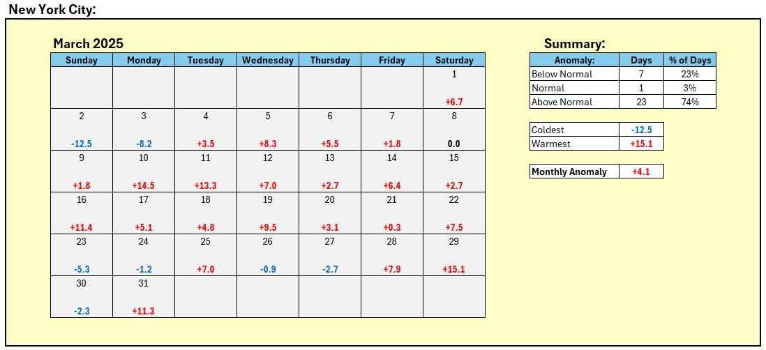
New York City is finishing March with a mean temperature of 46.9° (4.1° above normal). That makes March 2025 the 12th warmest March on record. A cold front will move slowly across the region tonight into tomorrow. It could be accompanied by strong thunderstorms, damaging winds, and heavy rainfall. A general 0.50"-1.50" rainfall with locally higher amounts is possible. In its wake, it will turn much cooler for tomorrow and Wednesday. It will again become unseasonably warm on Thursday. A cooler period will likely develop during the weekend. An AI random forest model currently suggests that April could wind up near or even somewhat below normal in New York City. A random forest model is a machine learning algorithm that combines the output of multiple decision trees to handle non-linear relationships to reach a single result. The ENSO Region 1+2 anomaly was +0.9°C and the Region 3.4 anomaly was -0.1°C for the week centered around March 19. For the past six weeks, the ENSO Region 1+2 anomaly has averaged +1.00°C and the ENSO Region 3.4 anomaly has averaged -0.18°C. Neutral ENSO conditions will likely continue into at least late spring. The SOI was +0.19 today. The preliminary Arctic Oscillation (AO) was +1.174 today.
-
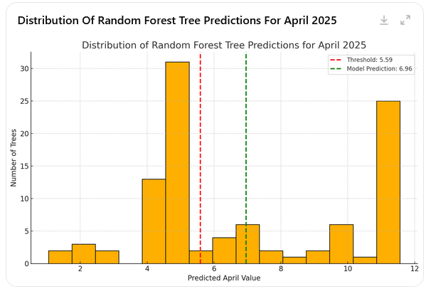
Consensus often does better than most forecasters on a consistent basis. It will be interesting to compare the consensus with the AI forecast for Boston, New York City, and Phoenix once the picks are in. The AI forecast anomalies were: Boston: +0.8, New York City: 0.0, and Phoenix: +0.9. In probabilistic terms, AI was broadly in line with today's CPC idea of "equal chances" for Boston and New York City and "above normal" for Phoenix. In terms of rainfall, "equal chances" applied to NYC and Phoenix, but CPC had below normal precipitation for Phoenix. Given the wet anomalies shown for Arkansas, I generated the AI forecast for Little Rock's April precipitation (6.96" vs. 5.59" normal value): Let's see how AI does finishes. Unfortunately, I didn't run the numbers for all of the cities, as I wasn't thinking of the contest at the time. I did look at a range of variable for New York City, as well as some variables for additional cities. Precipitation is tough to forecast. Maybe next month, I'll ask it for numbers for all of the contest cities to see how AI performs. I personally think AI likely has a long way to go when it comes to consistently skillful long-range forecasts e.g., monthly numbers. Maybe the AI-generated numbers will prove consistently good. We'll see.