donsutherland1
-
Posts
23,987 -
Joined
Content Type
Profiles
Blogs
Forums
American Weather
Media Demo
Store
Gallery
Everything posted by donsutherland1
-
OBS-Nowcast Noon Saturday 2/15-Noon Monday 2/17
donsutherland1 replied to wdrag's topic in New York City Metro
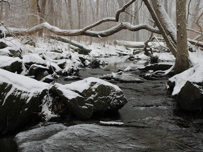
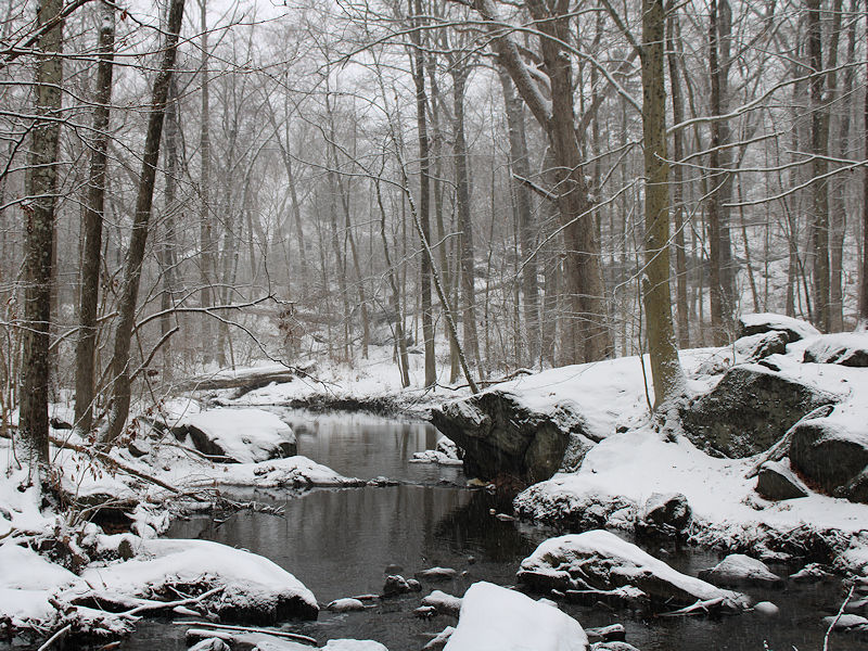
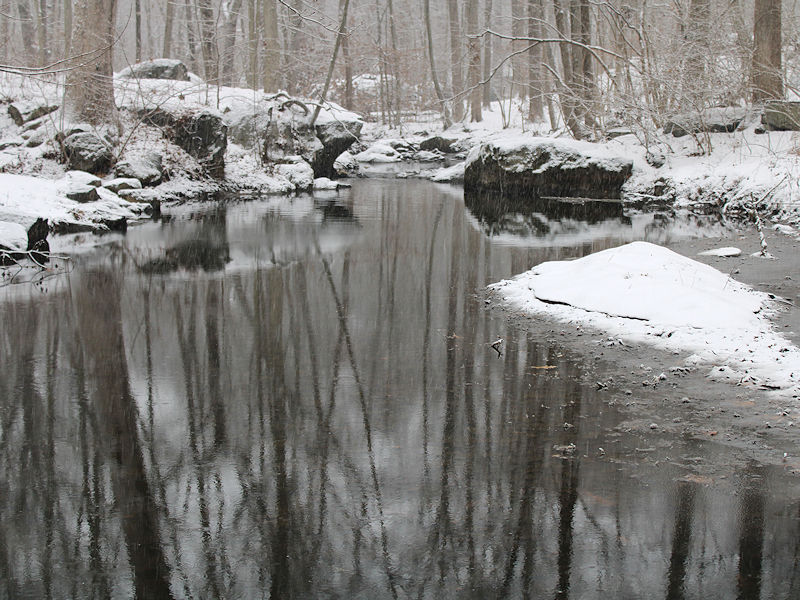
Four photos from this afternoon: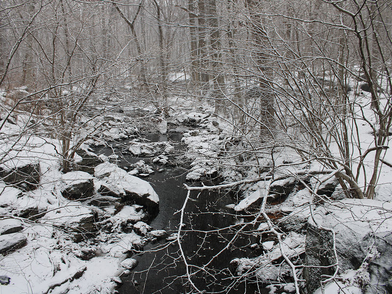
- 475 replies
-
- 13
-

-
For those who are interested, Results of a Series of Meteorological Observations, can be found at: https://archive.org/details/cu31924000010268/page/n27/mode/2up
-
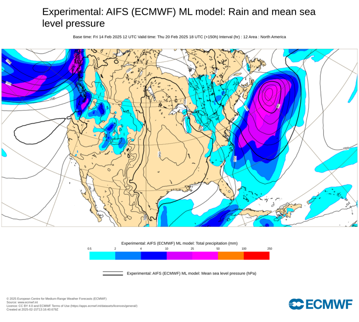
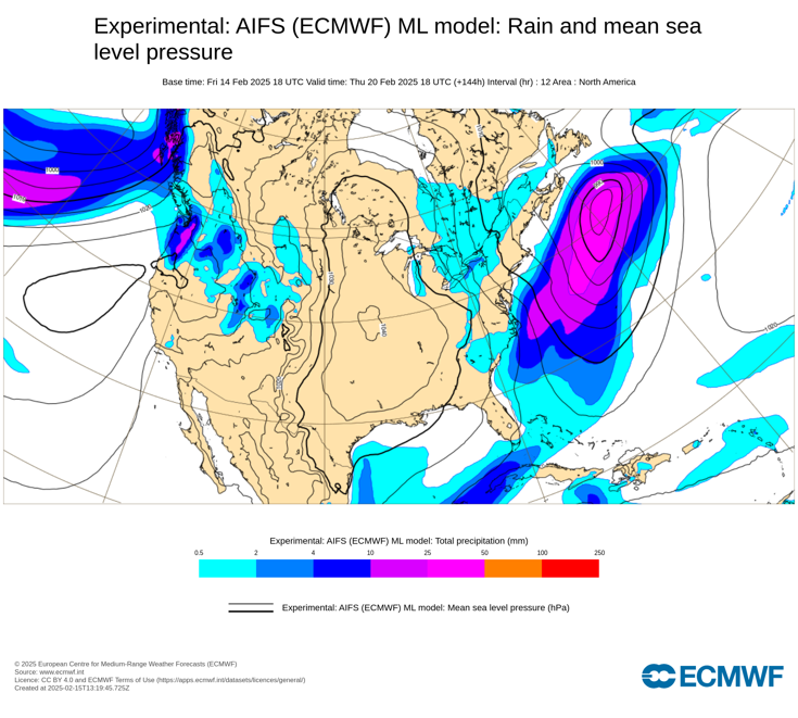
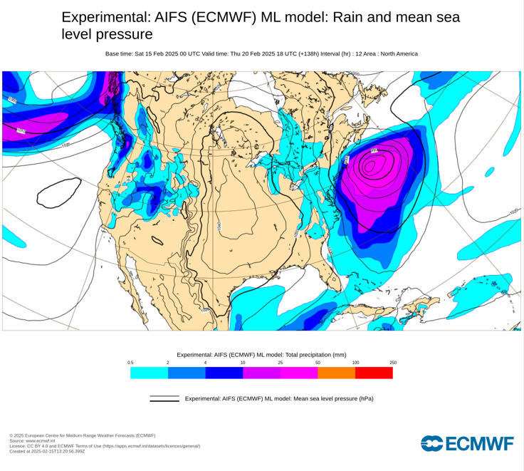
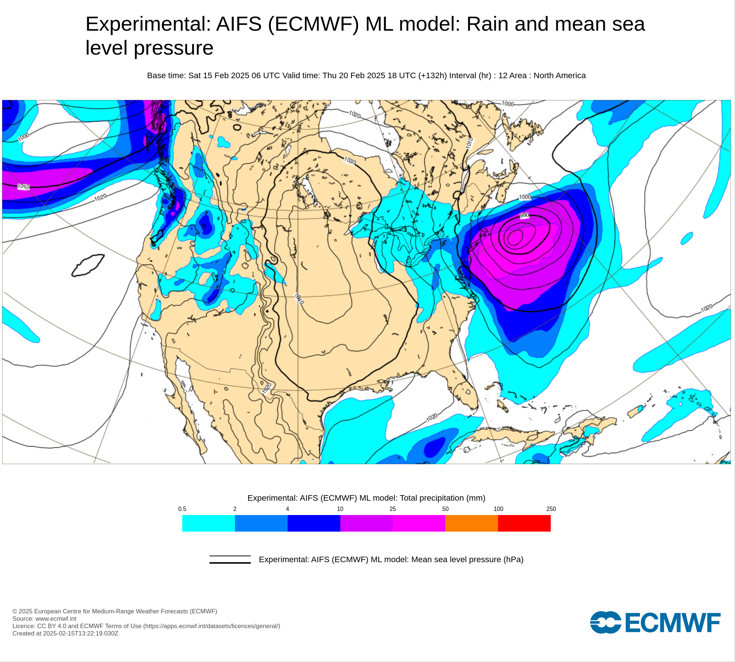
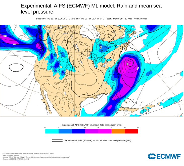
Last for ECMWF AIFS runs: 2/14 12z: 2/14 18z: 2/15 0z: 2/16 0z:
-
Some updates on last week’s thoughts: 1. Los Angeles picked up 2.12” of rain during February 12-13. San Francisco saw 2.29” during February 11-13. 2. The New York City area will likely experience experienced its biggest snowstorm of the season during February 8-9 when 3.1” of snow fell. Boston saw 5.5” of snow, as southern New England saw somewhat less snow than had been expected. However, Portland picked up 10.1” of snow during February 8-9. A second storm brought 6.4” of snow to Washington, DC during February 11-12. That was Washington’s second 6” or above snowstorm of the season. The last time Washington, DC saw two 6” or above snowstorms in a winter was 2013-2014. 3. Chicago picked up 3.0” of snow during February 11-13 while 3.8” fell in Detroit during February 12-13. Three Thoughts Going Forward: 1. A significant precipitation event will affect the Northeastern U.S. Albany, Boston, New York City, and Philadelphia could see 1”-2” of precipitation with locally higher amounts tonight and tomorrow. 2. The February 17-21 period could see the temperature average more than 10° below normal in parts of the Central Plains, including Des Moines, Kansas City, and Omaha. The coldest temperature could reach -10° or below in all three cities. There is a chance that Chicago could experience a subzero low temperature. The last time Chicago saw a subzero low temperature after February 14th was during March 4, 2019 when the mercury fell to -3°. 3. A significant (6” or more) snowfall is likely in parts of the East, particularly from Washington, DC to Atlantic City during February 19-20. Significant snow is possible but not assured in Baltimore, Philadelphia, and New York City. There is a chance that 10” or more snow could fall in parts of the Middle Atlantic region. Should Washington pick up 6” or more snow, that would be the third time this winter that the City had seen 6” or more snow during a storm. The last winter with three or more such storms was Winter 2009-2010 when there were four such storms. Longer-Range: The preponderance of guidance has now shifted toward a cooler than normal temperatures in much of the eastern United States, except for the Southeast during the second half of February overall. Precipitation for the Great Lakes Region and Northeast could be above normal during the second half of February. The Southwest will likely wind up warmer than normal. There are growing indications that a significant pattern realignment could occur near the end of February or during the start of March.
-
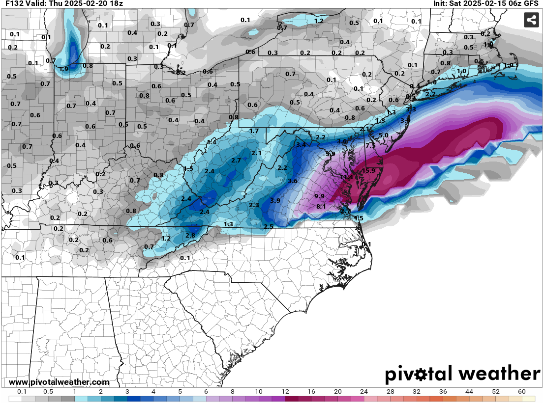
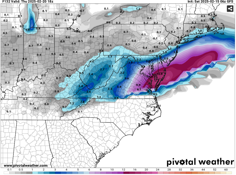
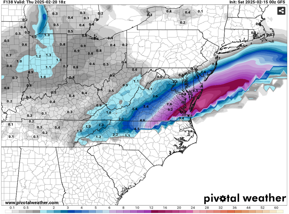
The 2/15 6z GFS has taken a minor step toward the snowier guidance. Whether this is the start of a model adjustment or just run-to-run discontinuity remains to be seen. 24-Hour Snowfall Forecasts: 2/15 0z GFS: 2/15 6z GFS:
-
This is probably the strongest signal one has seen this winter from the WPC:
-
Even more extreme -5.000 or below values have occurred in back-to-back months. Winter 1976-77 saw the AO fall to -5 or below in December and again in January. Winter 2009-10 saw the AO fall to -5 or below in December, January, and again in February.
-
Just one: January 18-20, 1985.
-
Tomorrow will be mostly cloudy. Snow will overspread the area during the late afternoon or evening. That snow will then change to sleet and rain. A 1"-3" accumulation is likely in and around New York City. A few places could see some somewhat higher amounts. The precipitation will continue into Sunday. A general 1"-2" of precipitation is likely from Washington, DC to New York City. Some locally higher amounts are possible. The temperature could surge into the 50s in New York City and lower 60s in Washington, DC on Sunday. In the wake of the storm, it will turn sharply colder on Monday. Temperatures could fall into the teens on Tuesday morning from Baltimore northward into New England. The cold will likely persist through the remainder of the week. A storm could bring snow to parts of the East Coast after the middle of next week. There is currently a large range of scenarios on the guidance. Overall, generally colder outcome is likely during the second half of February. Precipitation will likely be near or somewhat above normal. The ENSO Region 1+2 anomaly was +0.1°C and the Region 3.4 anomaly was -0.6°C for the week centered around February 5. For the past six weeks, the ENSO Region 1+2 anomaly has averaged -0.10°C and the ENSO Region 3.4 anomaly has averaged -0.72°C. La Niña conditions are underway and will likely persist into the start of spring. The SOI was -12.01 today. The preliminary Arctic Oscillation (AO) was -4.760 today. Based on sensitivity analysis applied to the latest guidance, there is an implied 93% probability that New York City will have a colder than normal February (1991-2020 normal). February will likely finish with a mean temperature near 32.4° (3.5° below normal).
-
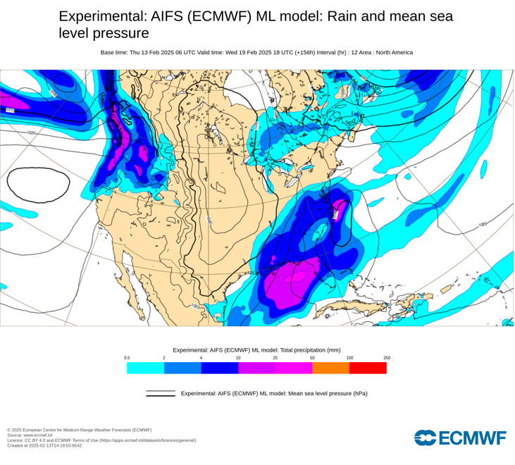
IMO, a wide range of options remains on the table. Out-to-sea (GFS, AIFS, Graphcast) or a significant storm (12z GGEM, 0z EPS/GEFS) are both plausible outcomes.
-
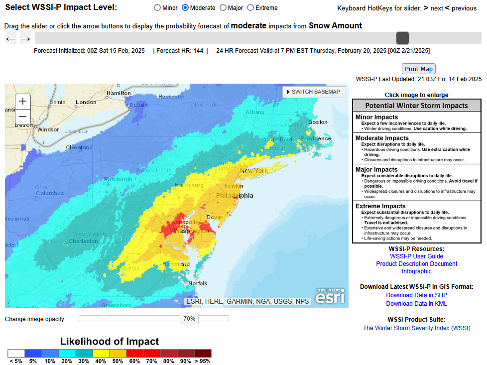
I finally had a chance to go back to look at the 2/13 0z ECMWF individual ensembles. I'm not sure where he gets the 1-in-4 odds. At 0z, the following was number and share of ensemble members showing 12" or more snow from the storm: NYC: 3 (6%) PHL: 4 (8%) DCA: 3 (6%) The 12z odds were higher, but again they did not even reach 20%.
-
Yes, 2014-15 was the last such winter.
-
Here's the full list:

-
Yes. That’s why there’s considerable room for change.
-
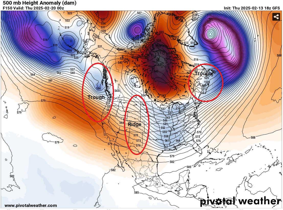
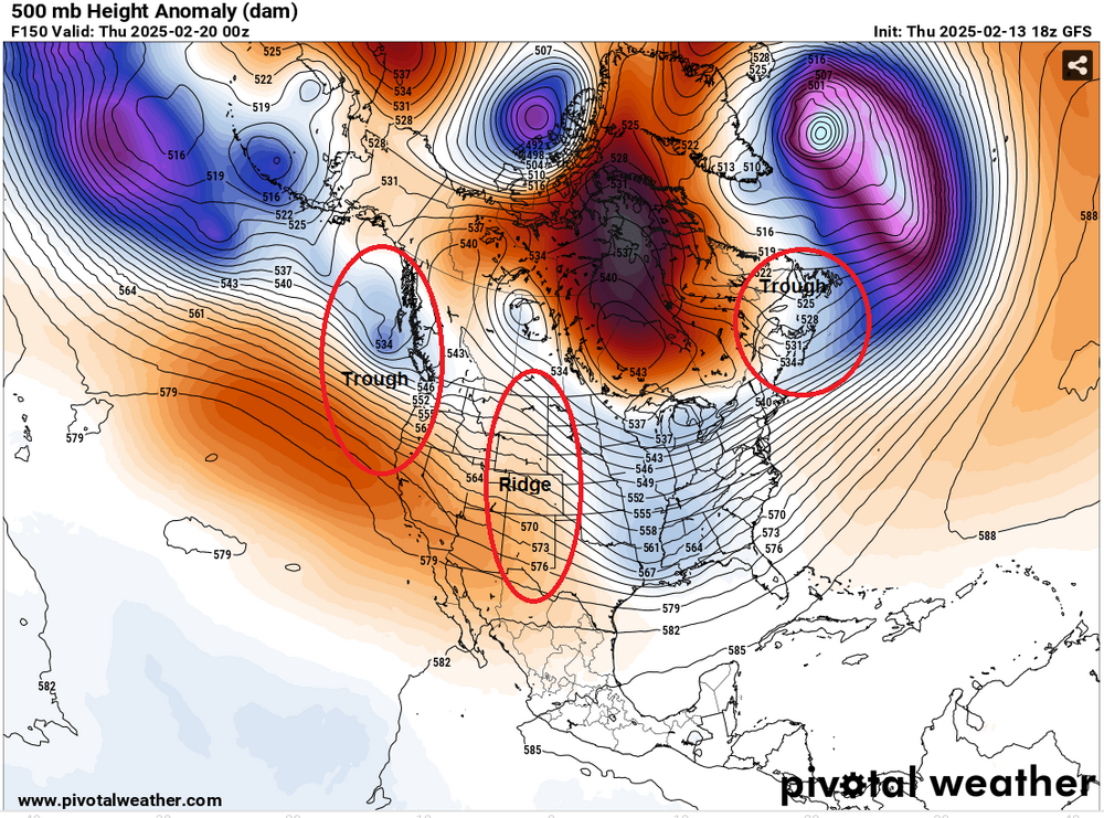
The 18z GFS had a largely suppressed solution. It showed a big snowfall in southeastern Virginia. I've taken the 500 mb map and identified where the features have typically been for blockbuster February snowstorms that occurred after February 7th and the cluster for such snowstorms during the second half of February. Details make a difference. If the ridging is on or off the Pacific Northwest at this time of year, one will be more likely than not to see a suppressed solution. The suppressed solution is consistent with the 500 mb pattern that operational GFS is forecasting. Fortunately, as this is an operational run at a 6-7 day timeframe, there remains considerable room for changes. Blockbuster February snowstorms for NYC (February 8-29):
-
It will turn colder tomorrow. Another storm will bring a period of snow changing to rain during the weekend. A 1"-3" accumulation is likely in and around New York City. A few places could see some slightly higher amounts. The precipitation will likely begin on Saturday and continue into Sunday. A general 1"-2" of precipitation is likely from Washington, DC to New York City. Some locally higher amounts are possible. The temperature could surge into the 50s in New York City and lower 60s in Washington, DC on Sunday. In the wake of the storm, it will turn sharply colder on Monday. Temperatures could fall into the teens on Tuesday morning from Baltimore northward into New England. The cold will likely persist through the remainder of the week. A storm could bring snow to parts of the East Coast after the middle of next week. Overall, generally colder outcome is likely during the second half of February. Precipitation will likely be near or somewhat above normal. The ENSO Region 1+2 anomaly was +0.1°C and the Region 3.4 anomaly was -0.6°C for the week centered around February 5. For the past six weeks, the ENSO Region 1+2 anomaly has averaged -0.10°C and the ENSO Region 3.4 anomaly has averaged -0.72°C. La Niña conditions are underway and will likely persist into the start of spring. The SOI was -5.43 today. The preliminary Arctic Oscillation (AO) was -3.663 today. Based on sensitivity analysis applied to the latest guidance, there is an implied 93% probability that New York City will have a colder than normal February (1991-2020 normal). February will likely finish with a mean temperature near 32.4° (3.5° below normal).
-
January 2026 wasn't on the list.
-
It didn't. It got 1.1" in 1983.
-
February 1989 is on the list; February 1983 is not.
-
No. I'm just illustrating that the range of possible outcomes is very large using Norfolk as an example.
-
The 12z GGEM shows > 10" snow in Norfolk and 1.5" for NYC. Since 1895, there have been 11 snowstorms that brought 10" or more snow to Norfolk. Eight (73%) had < 1" in New York City. The three (27%) with 1" or more, all had 6" or more. The most recent such storm was the Boxing Day Blizzard of 2010.
-
Here are the maps:
-
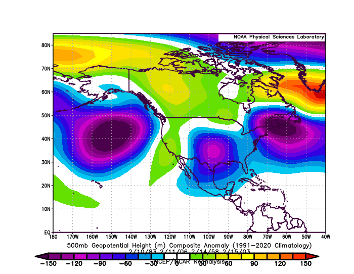
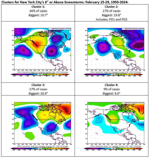
Social Media is the "Wild West" of forecasting. Anyone can put up an account and forecast. Many do. No verification is provided. Thus, there's no forecasting accountability. Moreover, the existing model is engagement-based and hype draws engagement. If one is looking for a major to blockbuster snowstorm, Cluster 2 is what one wants to see. It's that cluster that has seen storms bring significant to major snowfalls from Washington, DC to Boston during the second half of February. Below is the composite for KU snowstorms from February 8-29 (1950-2024): All the storms were Category 4 storms on the NESIS scale with only the February 2006 storm being a Category 3. Key Themes: 1. Cluster 2 and the more expansive timeframe both feature a deep trough in the vicinity of the Gulf of Alaska/off the Pacific Northwest and one over northeastern North America. 2. Cluster 2 and the more expansive timeframe also have a trough in the southern Plains. Synoptic details, whether one is looking for surface features or 500 mb vorticity, are really not reliable beyond 3 days (and sometimes fewer days). Thus, posted snowfall maps from 7-8 days out are really not very useful. Ensembles are more skillful. The ensembles suggest that the potential for snow exists for next week somewhere in the Middle Atlantic and/or southern New England regions. Pattern differences, including differences from the Clusters shown above, and the differences among the individual ensemble members suggest that it is far too soon to know whether there will be a moderate, significant, or major snowstorm, much less where the heaviest snows would fall were such a storm to materialize. Acknowledging the uncertainty and highlighting the limits of what is currently known does not generate excitement/engagement on Social Media. That reality, even as it is good forecasting practice, is exploited by those who hype without accountability. Finally, I'd like to see less ridging out in the Pacific Northwest region. With the shorter wave lengths, the kind of ridging that can work well in January can lead to more suppressed solutions during the second half of February.
-
Light snow with small flakes in Larchmont, but temperatures are above freezing and the snow is not sticking as of now.
-
Overnight, a storm passing well south of the region brought a light snowfall to the region. Snowfall amounts included: Atlantic City: 7.8" Baltimore: 3.8" Bridgeport: 2.0" New York City-Central Park: 1.5" New York City-JFK Airport: 1.8" New York City-LaGuardia Airport: 1.5" Newark: 1.5" Philadelphia: 3.1" Washington, DC: 6.4" The storm was Washington, DC's second 6" or greater snowstorm this winter. The last time a winter had two such storms was Winter 2013-2014. Another system will follow closely behind. This system will bring another light snowfall followed by a fairly quick changeover to sleet and then rain tomorrow. Little or no accumulation is likely in New York City. After mid-month, a period of much below normal temperatures is likely. A generally colder outcome is likely during the second half of February. Precipitation will likely be near or somewhat above normal. The ENSO Region 1+2 anomaly was +0.1°C and the Region 3.4 anomaly was -0.6°C for the week centered around February 5. For the past six weeks, the ENSO Region 1+2 anomaly has averaged -0.10°C and the ENSO Region 3.4 anomaly has averaged -0.72°C. La Niña conditions are underway and will likely persist into the start of spring. The SOI was +0.14 today. The preliminary Arctic Oscillation (AO) was -3.009 today. Based on sensitivity analysis applied to the latest guidance, there is an implied 86% probability that New York City will have a colder than normal February (1991-2020 normal). February will likely finish with a mean temperature near 32.7° (3.2° below normal).