

donsutherland1
-
Posts
24,197 -
Joined
Content Type
Profiles
Blogs
Forums
American Weather
Media Demo
Store
Gallery
Everything posted by donsutherland1
-
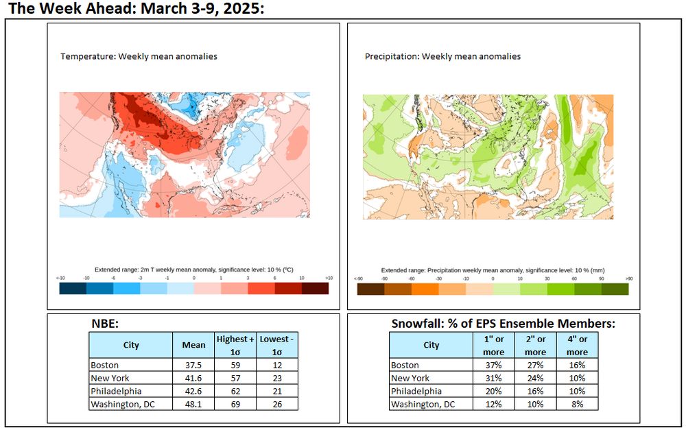
Probably little or no snow this month.
-
Rain will continue into early tomorrow. By the time the storm departs, a general 0.50"-1.50" of rain is likely from Philadelphia to Boston. The highest amounts could occur on parts of Long Island. Tomorrow will be another mild day with temperatures topping out in the middle 50s. Following the storm, it will turn somewhat colder, but not exceptionally cold for the weekend. Some additional precipitation is possible during the weekend, but the weekend should be mainly dry. The risk of a moderate (4" or more) or larger snowfall in the New York City area remains low through at least the first 10 days of March. The March 10-17 period could feature a bout of much above normal temperatures. The strong PNA ridge that predominated for most of the second half of February has all but broken down. However, the peak magnitude of that ridge suggests that the New York City area likely won't experience any major snowfalls for the remainder of the 2024-2025 snow season. The historic experience hints that the rising warmth of spring becomes too great to overcome by the time an otherwise favorable pattern for such snowfalls develops. The PNA reached +1.500 on February 19th and remained at or above +1.500 through February 23rd and at or above +1.000 through February 28th. In all 12 years that saw the PNA reach +1.500 or above on February 15 or later since 1950, the remainder of winter saw no 10" or greater snowstorms. If historic experience holds true yet again, that would make the 2024-2025 snow season the fourth consecutive snow season without a 10" or above snowstorm in New York City. The last time that happened was during 2016-2017 through 2019-2020. Most of the 12 cases cited above went on to see some additional measurable snowfall with a few seeing a 6"+ storm. The ENSO Region 1+2 anomaly was +1.1°C and the Region 3.4 anomaly was -0.2°C for the week centered around February 26. For the past six weeks, the ENSO Region 1+2 anomaly has averaged +0.35°C and the ENSO Region 3.4 anomaly has averaged -0.52°C. La Niña conditions will likely give way to neutral ENSO conditions during early spring. The SOI was +4.55 today. The preliminary Arctic Oscillation (AO) was +2.022 today.
-
The maps can be found here: https://frontierweather.dtn.com/verification.html
-
A storm will bring 0.50"-1.50" of rain from Philadelphia to Boston on tomorrow into Thursday. The highest amounts could be located across parts of Long Island. It will be unseasonably mild with temperatures topping out in the middle 50s on both days. Following the storm, it will turn somewhat colder, but not exceptionally cold. Some additional precipitation is possible during the weekend. The risk of a moderate (4" or more) or larger snowfall in the New York City area remains low through at least the first 10 days of March. The March 10-17 period could feature a bout of much above normal temperatures. The strong PNA ridge that predominated for most of the second half of February continues to fade. However, the peak magnitude of that ridge suggests that the New York City area likely won't experience any major snowfalls for the remainder of the 2024-2025 snow season. The historic experience hints that the rising warmth of spring becomes too great to overcome by the time an otherwise favorable pattern for such snowfalls develops. The PNA reached +1.500 on February 19th and remained at or above +1.500 through February 23rd and at or above +1.000 through February 28th. In all 12 years that saw the PNA reach +1.500 or above on February 15 or later since 1950, the remainder of winter saw no 10" or greater snowstorms. If historic experience holds true yet again, that would make the 2024-2025 snow season the fourth consecutive snow season without a 10" or above snowstorm in New York City. The last time that happened was during 2016-2017 through 2019-2020. Most of the 12 cases cited above went on to see some additional measurable snowfall with a few seeing a 6"+ storm. The ENSO Region 1+2 anomaly was +1.1°C and the Region 3.4 anomaly was -0.2°C for the week centered around February 26. For the past six weeks, the ENSO Region 1+2 anomaly has averaged +0.35°C and the ENSO Region 3.4 anomaly has averaged -0.52°C. La Niña conditions will likely give way to neutral ENSO conditions during early spring. The SOI was +3.30 today. The preliminary Arctic Oscillation (AO) was +1.724 today.
-
Weak El Niño.
-
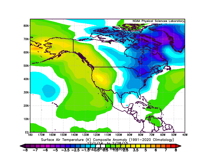
That's a nationwide map. The exceptional cold from 2014-15 was in the East and there was a lot of warmth in the West.
-
Temperatures will rebound quickly starting tomorrow. A storm will bring 0.50"-1.50" of rain from Philadelphia to Boston on Wednesday into Thursday. Two GFS runs notwithstanding, the risk of a moderate (4" or more) or larger snowfall in the New York City area remains low through at least the first 10 days of March. The March 10-17 period could feature a bout of much above normal temperatures. The strong PNA ridge that predominated for most of the second half of February is continuing to fade. However, the peak magnitude of that ridge suggests that the New York City area likely won't experience any major snowfalls for the remainder of the 2024-2025 snow season. The historic experience hints that the rising warmth of spring becomes too great to overcome by the time an otherwise favorable pattern for such snowfalls develops. The PNA reached +1.500 on February 19th and remained at or above +1.500 through February 23rd and at or above +1.000 through February 28th. In all 12 years that saw the PNA reach +1.500 or above on February 15 or later since 1950, the remainder of winter saw no 10" or greater snowstorms. If historic experience holds true yet again, that would make the 2024-2025 snow season the fourth consecutive snow season without a 10" or above snowstorm in New York City. The last time that happened was during 2016-2017 through 2019-2020. Most of the 12 cases cited above went on to see some additional measurable snowfall with a few seeing a 6"+ storm. The ENSO Region 1+2 anomaly was +1.1°C and the Region 3.4 anomaly was -0.2°C for the week centered around February 26. For the past six weeks, the ENSO Region 1+2 anomaly has averaged +0.35°C and the ENSO Region 3.4 anomaly has averaged -0.52°C. La Niña conditions will likely give way to neutral ENSO conditions during early spring. The SOI was +3.92 today. The preliminary Arctic Oscillation (AO) was +1.342 today.
-
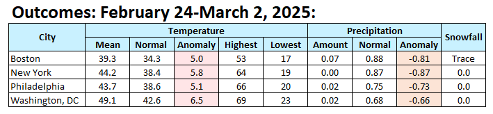
The final outcome:
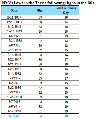
-
This morning, New York City had a low temperature of 19°. That was the first time the temperature had fallen into the teens in New York City in March since March 7, 2019 when the low temperature was 18°. Tomorrow will be another unseasonably cold day. Temperatures will top out in the middle and upper 30s in New York City. Low temperatures will start in the lower 20s in New York City and teens outside the City. Temperatures will rebound quickly starting Tuesday. A storm will bring 0.50"-1.50" of rain from Philadelphia to Boston on Wednesday into Thursday. No meaningful threats for a moderate or larger snowfall in the New York City area are likely through at least the first 10 days of March. The March 10-17 period could also feature a bout of much above normal temperatures. The strong PNA ridge that predominated for most of the second half of February is continuing to fade. However, the peak magnitude of that ridge suggests that the New York City area likely won't experience any major snowfalls for the remainder of the 2024-2025 snow season. The historic experience hints that the rising warmth of spring becomes too great to overcome by the time an otherwise favorable pattern for such snowfalls develops. The PNA reached +1.500 on February 19th and remained at or above +1.500 through February 23rd and at or above +1.000 through February 28th. In all 12 years that saw the PNA reach +1.500 or above on February 15 or later since 1950, the remainder of winter saw no 10" or greater snowstorms. If historic experience holds true yet again, that would make the 2024-2025 snow season the fourth consecutive snow season without a 10" or above snowstorm in New York City. The last time that happened was during 2016-2017 through 2019-2020. Most of the 12 cases cited above went on to see some additional measurable snowfall with a few seeing a 6"+ storm. The ENSO Region 1+2 anomaly was +0.9°C and the Region 3.4 anomaly was -0.3°C for the week centered around February 12. For the past six weeks, the ENSO Region 1+2 anomaly has averaged +0.03°C and the ENSO Region 3.4 anomaly has averaged -0.65°C. La Niña conditions have peaked and are beginning to fade. La Niña conditions will likely persist into the start of spring. The SOI was +1.53 today. The preliminary Arctic Oscillation (AO) was +1.311 today.
-
22 times: JFK's low was 23°.
-
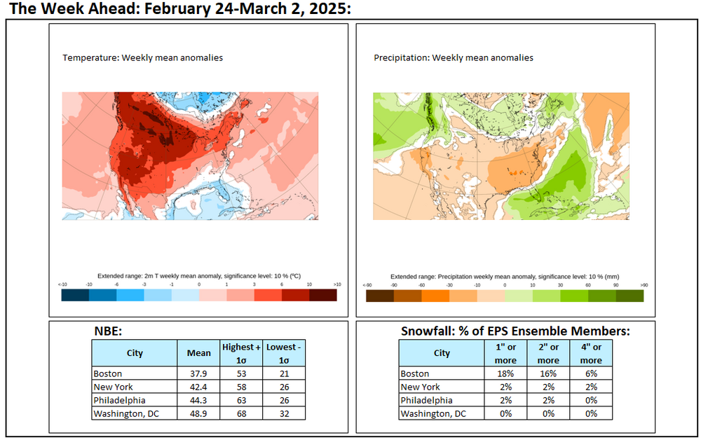
The week ahead on the guidance:
-
Central Park has fallen to 19° so far. That is the first time Central Park has been in the teens in March since March 7, 2019 when the mercury fell to 18°.
-
Ahead of a strong cold front, temperatures surged into the 50s and 60s across the region. High temperatures included: Atlantic City: 68° Baltimore: 66° Bridgeport: 57° Islip: 52° New York City-Central Park: 64° New York City-JFK Airport: 67° (old record: 61°, 2017) New York City-LaGuardia Airport: 65° Newark: 65° Philadelphia: 66° Washington, DC: 69° Much colder air is now pouring into the region on a stiff wind following today's springlike warmth. The brief but sharp shot of cold will be in place tomorrow and Monday. Tomorrow and Monday will see temperatures top out in the lower and middle 30s in New York City. Low temperatures will reach the lower 20s in New York City and teens outside the City. There is a chance that New York City could see its high temperature reach no higher than freezing tomorrow. The last time New York City had a high of 32° in March was March 7, 2019. The last time New York City had a high below 32° in March was March 6, 2019 when the temperature topped out at 26°. Temperatures will rebound quickly starting Tuesday. A moderate to possibly significant rainfall is possible Wednesday into Thursday. No meaningful threats for a moderate or larger snowfall in the New York City area are likely through at least the first week of March. The strong PNA ridge that predominated for most of the second half of February is finally fading. But magnitude of that ridge suggests that the New York City area likely won't experience any major snowfalls during Winter 2024-2025. The historic experience hints that the rising warmth of spring becomes too great to overcome by the time an otherwise favorable pattern for such snowfalls develops. The PNA reached +1.500 on February 19th and remained at or above +1.500 through February 23rd and at or above +1.000 through February 28th. In all 12 years that saw the PNA reach +1.500 or above on February 15 or later since 1950, the remainder of winter saw no 10" or greater snowstorms. If historic experience holds true yet again, that would make the Winter 2024-2025 the fourth consecutive winter without a 10" or above snowstorm in New York City. The last time that happened was during Winter 2016-2017 through Winter 2019-2020. Most of the 12 winters cited above went on to see some additional measurable snowfall with a few seeing a 6"+ storm. The ENSO Region 1+2 anomaly was +0.9°C and the Region 3.4 anomaly was -0.3°C for the week centered around February 12. For the past six weeks, the ENSO Region 1+2 anomaly has averaged +0.03°C and the ENSO Region 3.4 anomaly has averaged -0.65°C. La Niña conditions have peaked and are beginning to fade. La Niña conditions will likely persist into the start of spring. The SOI was +2.54 today. The preliminary Arctic Oscillation (AO) was +0.096 today.
-
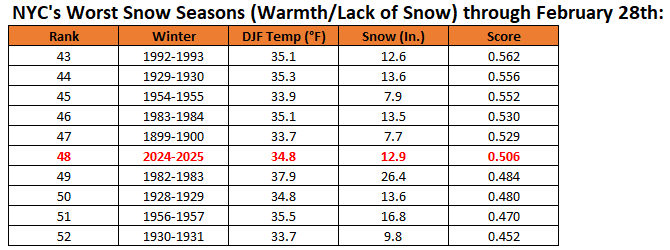
1992-1993 fell to 63rd worst winter (and would likely rank as the 64th worst once this winter concludes).
-
Updates on last week’s thoughts: 1. heavy rain did not materialize for Galveston and Houston last weekend. Instead, a lighter rainfall occurred. 2. The Southwest experienced much warmer than normal conditions from Monday through Friday. Phoenix reached 90° on February 25th, its fourth earliest such temperature on record. Tucson tied its high for the year, so far, with a temperature of 86° on February 24 and February 25. 3. No significant (6” or above) snowstorms occurred in Washington, DC to Boston or in the major Great Lakes cities (Chicago, Detroit, Indianapolis, Milwaukee, and Toronto).
-
Final January Anomalies:
-
Winter rankings for New York City (through February 28th):
-
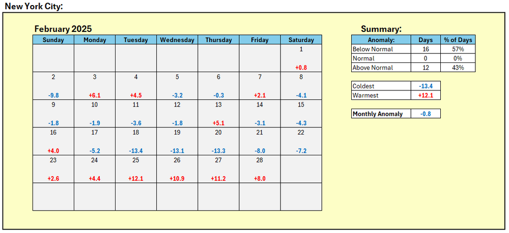
February is concluding with a mean temperature of 35.1° (0.8° below normal) in New York City. Winter 2024-2025 will finish with a seasonal mean temperature of 34.8° (1.4° below normal). Winter 2024-2025 is the coldest winter since Winter 2014-2015 when the seasonal average temperature was 31.7°. The very mild weather will prevail into the first day of March before a brief shot of much colder air arrives for Sunday and Monday. Sunday and Monday will see temperatures top out in the lower and middle 30s in New York City. Temperatures will rebound quickly starting Tuesday. No meaningful threats for a moderate or larger snowfall in the New York City area are likely through at least the the first week of March. A strong PNA ridge is currently in place. Historical experience suggests that the presence of such a ridge during the second half of February has been followed by the absence of major snowfalls in the New York City area. The PNA reached +1.500 on February 19th and remained at or above +1.500 through February 23rd. In all 12 years that saw the PNA reach +1.500 or above on February 15 or later since 1950, the remainder of winter saw no 10" or greater snowstorms. If historic experience holds true yet again, that would make the Winter 2024-2025 the fourth consecutive winter without a 10" or above snowstorm in New York City. The last time that happened was during Winter 2016-2017 through Winter 2019-2020. Most of the 12 winters cited above went on to see some additional measurable snowfall with a few seeing a 6"+ storm. The ENSO Region 1+2 anomaly was +0.9°C and the Region 3.4 anomaly was -0.3°C for the week centered around February 12. For the past six weeks, the ENSO Region 1+2 anomaly has averaged +0.03°C and the ENSO Region 3.4 anomaly has averaged -0.65°C. La Niña conditions have peaked and are beginning to fade. La Niña conditions will likely persist into the start of spring. The SOI was +0.24 today. The preliminary Arctic Oscillation (AO) was +0.315 today.
-
During Winter 2024-2025, the Arctic Oscillation (AO) had a preliminary average of -0.374. The AO was negative on 53% of days and at or below -1.000 on 34% of days. The AO was positive on 47% of days and at or above +1.000 on 24% of days. In terms of extreme values, the AO was at -3.000 or below on 12% of days and at or above +3.000 on 3% of days. The lowest AO value of -5.257 (preliminary) was reached on February 15th. The highest AO value of +3.439 was reached on January 24th.
-
March DCA _ NYC _ BOS __ ORD _ ATL _ IAH __ DEN _ PHX _ SEA 2.0 1.4 1.4 3.6 2.0 3.2 2.4 1.0 -0.3
-
Today's firing of NWS and NOAA personnel is about as appalling a development as can be. In A.G. Riddle’s The Long Winter Trilogy, humanity faces an unfeeling force of destruction—the Harvester. This alien machine does not negotiate, does not pause, and does not care. It exists solely to extract energy from stars, including our Sun, draining it relentlessly while life on Earth shivers and fades into darkness. The Harvester does not acknowledge suffering. It does not see the devastation it leaves in its wake. It consumes, and the world dies. But this is no longer science fiction. The United States now faces its own Harvester—one not born in the emptiness of space, but in the corridors of unchecked power. In the opening days of the Trump administration, Elon Musk and his DOGE entity emerged—not through democratic process, not through congressional approval, but by executive fiat. Like the Harvester, DOGE was created for one purpose: extraction. The rhetoric of “efficiency,” “cost-saving,” and “government reform” is seductive. But beneath these noble-sounding claims lies a much darker reality. Musk and DOGE are not restructuring the federal government to improve it. They are stripping it for parts. They fire workers unlawfully, terminate vital contracts without cause, and consume vast amounts of private data. They suffocate research by cutting critical funding, impose crippling layoffs on the National Weather Service, and collude with Republican lawmakers to siphon wealth from Medicaid and public health initiatives, all to redirect that money into their own coffers via misguided tax cuts that serve no meaningful macroeconomic purpose. Musk, DOGE, and their allies are not just attacking government institutions. They are devouring the ethical foundation of democracy itself. They are dismantling the compassion that fueled the nation’s pursuit of a “more perfect Union.” They are obliterating the moderation that once guided civil discourse and policy. They are strangling the empathy that holds society together. And they are doing it by design. They do not care about the consequences. Families left jobless, children gone hungry, scientific advancements lost, and the lives put at risk don’t matter to them. Like the Harvester, they extract. They consume. Then, they will move on. Today, the courts struggle to contain the DOGE Blitzkrieg. Congressional opposition remains divided and hesitant. Corporations bow before the new order. But the people still hold power. The Harvester only wins if we surrender in silence. The dismantling of democracy is a lengthy hollowing-out before the collapse. Collapse is only made possible by the apathy of those who refuse to resist. Elie Wiesel, who bore witness to some of history’s darkest times, left us with this charge: “There may be times when we are powerless to prevent injustice, but there must never be a time when we fail to protest.” That time for protest is now.
-
The very mild weather will prevail into the first day of March before a brief shot of much colder air arrives for Sunday and Monday. Sunday and Monday will see temperatures top out in the lower and middle 30s in New York City. Temperatures will reebound quickly starting Tuesday. No meaningful threats for a moderate or larger snowfall in the New York City area are likely through at least the middle of the first week of March. There remain indications that a major pattern re-alignment could take place starting in the first week of March bringing an end to a persistently cold regime that has predominated through most of the winter. By mid-March, a sustained warmer than normal pattern could be in place. The pattern change will likely follow a brief but fairly sharp cold shot. A strong PNA ridge is currently in place. Historical experience suggests that the presence of such a ridge at this time of year has been followed by the absence of major snowfalls in the New York City area. The PNA reached +1.500 on February 19th and remained at or above +1.500 through February 23rd. In all 12 years that saw the PNA reach +1.500 or above on February 15 or later since 1950, the remainder of winter saw no 10" or greater snowstorms. If historic experience holds true yet again, that would make the Winter 2024-2025 the fourth consecutive winter without a 10" or above snowstorm in New York City. The last time that happened was during Winter 2016-2017 through Winter 2019-2020. Most of the 12 winters cited above went on to see some additional measurable snowfall with a few seeing a 6"+ storm. The ENSO Region 1+2 anomaly was +0.9°C and the Region 3.4 anomaly was -0.3°C for the week centered around February 12. For the past six weeks, the ENSO Region 1+2 anomaly has averaged +0.03°C and the ENSO Region 3.4 anomaly has averaged -0.65°C. La Niña conditions have peaked and are beginning to fade. La Niña conditions will likely persist into the start of spring. The SOI was +1.92 today. The SOI was unchanged from the previous day for the first time since June 15, 2024. The preliminary Arctic Oscillation (AO) was -0.503 today. Based on sensitivity analysis applied to the latest guidance, there is an implied near 100% probability that New York City will have a colder than normal February (1991-2020 normal). February will likely finish with a mean temperature near 35.0° (0.9° below normal).
-
That's a pretty bold paper. Right now, it's a pre-print. Peer-review hasn't been completed. If its conclusions hold up, that would a fairly big development.
-
And 23.7" after March 15th.
-
What you state contradicts the First Law of Thermodynamics. When particles pop into existence, they borrow energy from what's known as vacuum energy. They don't create energy. The First Law applies to quantum mechanics.


