donsutherland1
-
Posts
24,197 -
Joined
Content Type
Profiles
Blogs
Forums
American Weather
Media Demo
Store
Gallery
Everything posted by donsutherland1
-
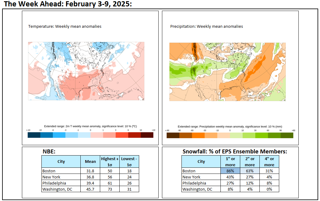
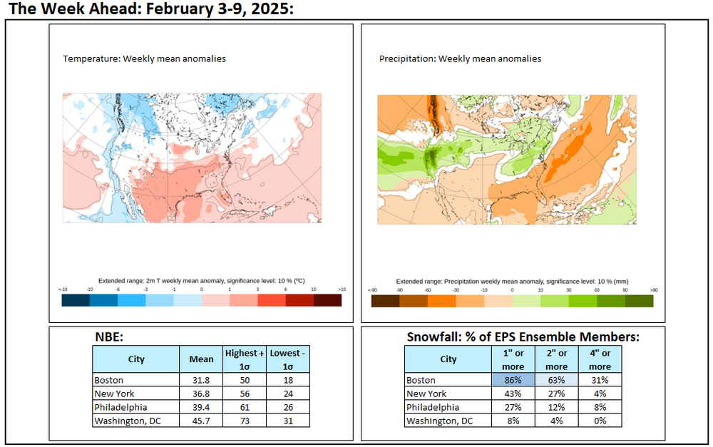
It will be increasingly cloudy tomorrow. Light snow will likely overspread the New York City area late tomorrow afternoon or during the evening hours. A general 1"-3" snowfall is likely in New York City and nearby suburbs by the time the snow ends on Wednesday. The highest amounts will be south of the City. Amounts will rapidly fall off in the Hudson Valley. Washington, DC could see its second 6" or above snowstorm this winter for the first time since Winter 2013-2014. Another system could follow closely behind. This system will likely bring another light snowfall followed by a changeover to sleet and then rain. No exceptional warmth or cold is likely through at least February 14th. A generally colder outcome appears more likely than not during the second half of February. Precipitation will likely be near or somewhat above normal. The ENSO Region 1+2 anomaly was +0.1°C and the Region 3.4 anomaly was -0.6°C for the week centered around February 5. For the past six weeks, the ENSO Region 1+2 anomaly has averaged -0.10°C and the ENSO Region 3.4 anomaly has averaged -0.72°C. La Niña conditions are underway and will likely persist into the start of spring. The SOI was +16.86 today. The preliminary Arctic Oscillation (AO) was -1.910 today. Based on sensitivity analysis applied to the latest guidance, there is an implied 85% probability that New York City will have a colder than normal February (1991-2020 normal). February will likely finish with a mean temperature near 32.7° (3.2° below normal).
-
Final outcomes:
-
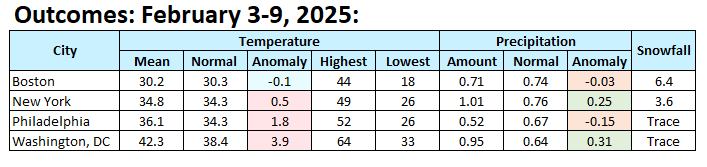
The New York City area saw its biggest snowfall of the year last night into very early this morning. In general, New York City saw 2"-4" of snow while distant northern and eastern suburbs picked up 3"-6" of snow. Accumulations included: Bridgeport: 5.0" Islip: 4.0" New York City-Central Park: 3.1" New York City-JFK Airport: 3.4" New York City-LaGuardia Airport: 3.6" Newark: 3.0" Another storm could affect the region late Tuesday night and Wednesday. Its exact track will be crucial to determining whether the region is merely grazed by the storm with a light accumulation or experiences a moderate to perhaps significant snowfall. Currently, the odds lean toward a 1"-3"/2"-4"-type snowfall in and around New York City, but there remains some uncertainty about the storm's track. Washington, DC could see its second 6" or above snowstorm this winter for the first time since Winter 2013-2014. No exceptional warmth or cold is likely through at least February 14th. A generally colder outcome appears more likely than not during the second half of February. Precipitation will likely be near or somewhat above normal. The ENSO Region 1+2 anomaly was -0.6°C and the Region 3.4 anomaly was -0.8°C for the week centered around January 29. For the past six weeks, the ENSO Region 1+2 anomaly has averaged -0.13°C and the ENSO Region 3.4 anomaly has averaged -0.63°C. La Niña conditions are underway and will likely persist into the start of spring. The SOI was +28.10 today. The preliminary Arctic Oscillation (AO) was -1.598 today. Based on sensitivity analysis applied to the latest guidance, there is an implied 83% probability that New York City will have a colder than normal February (1991-2020 normal). February will likely finish with a mean temperature near 32.9° (3.0° below normal).
-
The website came back online. During 1950-1999, there were two blocking episodes (AO -4 or below) where the ridges linked up. Since 2000, there have been 3 cases. That means that the 2000-2024 period has seen such episodes twice as frequently as during the 1950-1999 period.
-
I wanted to start checking, but the site is again down:
-
I am not aware of any database that has such information. Anecdotally, recently years have seen this happen more frequently than in the past, which would make sense that such ridging has grown more expansive. I will try to run data for AO -4 or below cases.
-
The NWS New York PNS has just been posted: 599 NOUS41 KOKX 091443 PNSOKX CTZ005>012-NJZ002-004-006-103>108-NYZ067>075-078>081-176>179-100243- Public Information Statement National Weather Service New York NY 943 AM EST Sun Feb 9 2025 ...SNOWFALL AND ICE REPORTS FROM SATURDAY EVENING THROUGH THIS MORNING... ...SNOWFALL REPORTS... Location Amount Time/Date Provider ...Connecticut... ...Fairfield County... Bridgeport Airport 5.0 in 0700 AM 02/09 Official NWS Obs Bridgeport 5.0 in 0700 AM 02/09 HADS 1 E Danbury 5.0 in 0700 AM 02/09 Trained Spotter New Canaan 5.0 in 0800 AM 02/09 COCORAHS Ridgefield 4.8 in 0700 AM 02/09 COCORAHS Ridgefield 2.4 NNE 4.6 in 0700 AM 02/09 COCORAHS Bethel 4.5 in 0600 AM 02/09 Emergency Mngr 3 NNE Southport 4.4 in 0600 AM 02/09 Public Stamford 1.0 S 4.4 in 0800 AM 02/09 COCORAHS 4 NNW New Fairfield 4.2 in 0630 AM 02/09 Trained Spotter Southport 4.1 in 0130 AM 02/09 Public Norwalk 4.1 in 0700 AM 02/09 COCORAHS 2 N Stamford 4.1 in 0800 AM 02/09 Public Stratford 4.0 in 0700 AM 02/09 COCORAHS Easton 4.0 in 0800 AM 02/09 Public 2 SSW Weston 3.8 in 1200 AM 02/09 Trained Spotter Bethel 4.5 SSE 3.7 in 0700 AM 02/09 COCORAHS ...Middlesex County... Killingworth 4.5 in 0700 AM 02/09 COCORAHS Clinton 4.4 in 0900 AM 02/09 Broadcast Media Durham 4.0 in 0700 AM 02/09 COCORAHS Higganum 4.0 in 0800 AM 02/09 COCORAHS Westbrook 3.8 in 0649 AM 02/09 Trained Spotter Middlefield 1.4 W 3.7 in 0600 AM 02/09 COCORAHS ...New Haven County... Hamden 5.2 in 0800 AM 02/09 Trained Spotter Seymour 5.0 in 0107 AM 02/09 Trained Spotter North Haven 5.0 in 0810 AM 02/09 Trained Spotter Madison Center 1.3 N 4.2 in 0700 AM 02/09 COCORAHS 1 ENE North Haven 4.0 in 1200 AM 02/09 Trained Spotter Branford 4.0 in 1200 AM 02/09 Public Southbury 2.3 W 4.0 in 0800 AM 02/09 COCORAHS Wallingford 3.8 in 0825 AM 02/09 Public 1 NNW Meriden 3.6 in 0145 AM 02/09 Public Prospect 3.6 in 0700 AM 02/09 COCORAHS Naugatuck 3.5 in 0700 AM 02/09 COCORAHS Meriden 3.5 in 0700 AM 02/09 COCORAHS Waterbury 3.3 in 1230 AM 02/09 Trained Spotter Waterbury 3.0 in 0700 AM 02/09 COCORAHS ...New London County... Old Lyme 1.7 NNE 5.0 in 0700 AM 02/09 COCORAHS New London 4.7 in 0600 AM 02/09 COCORAHS Mystic 4.6 in 0700 AM 02/09 COCORAHS Groton 4.5 in 0100 AM 02/09 Public Niantic 4.5 in 0500 AM 02/09 COCORAHS East Lyme 4.5 in 0600 AM 02/09 COCORAHS Pawcatuck 4.5 in 0800 AM 02/09 COCORAHS 1 SSW New London 4.2 in 0245 AM 02/09 Trained Spotter Waterford 4.2 in 0700 AM 02/09 COCORAHS Norwich 4.0 in 0700 AM 02/09 COOP Norwich 5.2 SE 4.0 in 0700 AM 02/09 COCORAHS Uncasville 2.4 NNW 3.9 in 0700 AM 02/09 COCORAHS 4 SW Voluntown 3.8 in 0727 AM 02/09 Public Norwich 3.6 in 0600 AM 02/09 COCORAHS ...New Jersey... ...Bergen County... North Arlington 3.0 in 0800 AM 02/09 COCORAHS Montvale 1.8 ESE 3.0 in 0800 AM 02/09 COCORAHS Oakland 3.0 in 0800 AM 02/09 COCORAHS Fair Lawn 3.0 in 0822 AM 02/09 COCORAHS East Rutherford 2.9 in 1050 PM 02/08 Trained Spotter Franklin Lakes 2.6 in 1025 PM 02/08 Public Hasbrouck Heights 2.5 in 1151 AM 02/08 Public River Edge 0.4 NNE 1.8 in 0600 AM 02/09 COCORAHS ...Essex County... West Orange 3.0 in 0100 AM 02/09 Public North Caldwell 3.0 in 0445 AM 02/09 Public Montclair 2.8 in 0800 AM 02/09 COCORAHS ...Hudson County... Harrison 2.8 in 0700 AM 02/09 COOP 1 WSW Hoboken 2.6 in 0800 AM 02/09 COCORAHS Hoboken 2.1 in 1000 PM 02/08 Trained Spotter ...Passaic County... Little Falls 3.1 in 0700 AM 02/09 COCORAHS ...Union County... Newark Airport 3.0 in 0700 AM 02/09 Official NWS Obs Elizabeth 2.8 in 1200 AM 02/09 Trained Spotter Cranford Twp 0.6 NNW 2.4 in 0800 AM 02/09 COCORAHS Westfield 2.0 in 0615 AM 02/09 COCORAHS ...New York... ...Bronx County... 1 ENE Fordham 4.6 in 1215 AM 02/09 Public 1 NW Fordham 3.1 in 0701 AM 02/09 ...Kings County... 1 WNW Crown Heights 3.0 in 1200 AM 02/09 Trained Spotter Sheepshead Bay 3.0 in 1230 AM 02/09 Trained Spotter Midwood 2.8 in 1200 AM 02/09 Broadcast Media ...Nassau County... Muttontown 5.1 in 1250 AM 02/09 Public Jericho 4.9 in 1200 AM 02/09 Public Hicksville 1.4 SSE 4.3 in 0700 AM 02/09 COCORAHS 2 N Massapequa 4.2 in 0250 AM 02/09 Trained Spotter Syosset 4.0 in 1230 AM 02/09 Trained Spotter Manhasset Hills 3.9 in 1200 AM 02/09 Public Herricks 3.9 in 0830 AM 02/09 COCORAHS Westbury 3.8 in 1045 PM 02/08 Public Floral Park 3.7 in 1200 AM 02/09 Public Plainview 3.6 in 0245 AM 02/09 Public Farmingdale 3.5 in 1045 PM 02/08 Public 1 WSW Plainview 3.5 in 1051 PM 02/08 Public Hicksville 3.5 in 1130 PM 02/08 Public Syosset 3.5 in 0800 AM 02/09 COOP Massapequa Park 3.2 in 0700 AM 02/09 COCORAHS Sea Cliff 3.1 in 1133 PM 02/08 Public Bellmore 3.0 in 1115 PM 02/08 Public Bethpage 2.8 in 1050 PM 02/08 Public Merrick 2.8 in 0115 AM 02/09 Trained Spotter Seaford 0.4 SE 2.2 in 0700 AM 02/09 COCORAHS ...New York (Manhattan) County... Central Park 3.1 in 0700 AM 02/09 Official NWS Obs 1 SSW Greenwich Village 1.5 in 0830 AM 02/09 Public ...Orange County... Washingtonville 4.1 in 0600 AM 02/09 Trained Spotter Chester 3.9 in 0825 AM 02/09 Public 4 SSE Chester 3.8 in 0700 AM 02/09 COCORAHS 1 WNW Monroe 3.8 in 0700 AM 02/09 Trained Spotter 2 E Highland Mills 3.5 in 1100 PM 02/08 Public Warwick 3.1 in 0700 AM 02/09 COCORAHS Greenwood Lake 2.8 in 0800 AM 02/09 COCORAHS Port Jervis 2.6 in 0630 AM 02/09 COCORAHS ...Putnam County... Cold Spring 3.0 in 0700 AM 02/09 COCORAHS ...Queens County... Whitestone 4.1 in 0800 AM 02/09 Public NYC/La Guardia 3.6 in 0700 AM 02/09 Official NWS Obs NYC/JFK 3.4 in 0925 AM 02/09 Official NWS Obs Little Neck 0.3 SE 3.2 in 0800 AM 02/09 COCORAHS Bellerose 3.1 in 1225 AM 02/09 Public 2 S Elmhurst 2.4 in 0730 AM 02/09 Trained Spotter ...Richmond County... Dongan Hills 2.2 in 1250 AM 02/09 Public ...Rockland County... Stony Point 3.9 in 0700 AM 02/09 COCORAHS New City 3.5 in 0700 AM 02/09 Trained Spotter ...Suffolk County... 1 SSE Commack 5.0 in 0100 AM 02/09 Public Hauppauge 5.0 in 0230 AM 02/09 Public Smithtown 5.0 in 0445 AM 02/09 Trained Spotter Ridge 1.5 SE 5.0 in 0500 AM 02/09 COCORAHS Commack 4.8 in 1215 AM 02/09 Public Hampton Bays 4.8 in 0150 AM 02/09 Public 1 S Port Jefferson 4.8 in 0230 AM 02/09 Public Centerport 4.7 in 0700 AM 02/09 COOP Upton 4.6 in 0700 AM 02/09 COOP Yaphank 4.5 in 1115 PM 02/08 Public Centereach 4.5 in 1205 AM 02/09 NWS Employee North Patchogue 4.5 in 0105 AM 02/09 Public Stony Brook 4.5 in 0130 AM 02/09 Public 1 N Setauket-East Seta 4.5 in 0555 AM 02/09 NWS Employee Commack 1.3 SW 4.5 in 0700 AM 02/09 COCORAHS Smithtown 4.5 in 0720 AM 02/09 Trained Spotter Stony Brook 4.4 in 0845 AM 02/09 NWS Employee Ridge 4.3 in 1159 PM 02/08 COCORAHS Ronkonkoma 4.3 in 1230 AM 02/09 Public Hauppauge 4.3 in 0720 AM 02/09 Trained Spotter 2 E Commack 4.3 in 0730 AM 02/09 Broadcast Media Miller Place 4.2 in 1150 AM 02/08 Public Center Moriches 4.1 in 0600 AM 02/09 COCORAHS Islip Terrace 4.0 in 1200 AM 02/09 Trained Spotter 1 WSW Commack 4.0 in 1200 AM 02/09 Broadcast Media Islip Airport 4.0 in 0700 AM 02/09 Official NWS Obs Deer Park 3.8 in 1240 AM 02/09 Public East Quogue 3.6 in 0400 AM 02/09 NWS Employee Sayville 3.5 in 1055 PM 02/08 Public Patchogue 3.4 in 1115 PM 02/08 NWS Employee Babylon 3.3 in 1030 PM 02/08 Public Islip Terrace 0.5 W 3.3 in 0700 AM 02/09 COCORAHS Smithtown 3.2 in 0945 PM 02/08 Public Amityville 3.0 in 0800 AM 02/09 COCORAHS Manorville 2.9 in 1024 PM 02/08 Public Sayville 2.9 in 0700 AM 02/09 NWS Employee Bay Shore 2.9 in 0730 AM 02/09 NWS Employee East Islip 2.5 in 1045 PM 02/08 Public ...Westchester County... Armonk 4.0 in 0800 AM 02/09 COCORAHS Peekskill 4.0 in 0800 AM 02/09 Trained Spotter Shrub Oak 3.8 in 0630 AM 02/09 COOP Peekskill 2.8 NNE 3.7 in 0700 AM 02/09 COCORAHS South Salem 3.7 in 0715 AM 02/09 COCORAHS Eastchester 3.5 in 1135 PM 02/08 Public Ossining 3.5 in 1215 AM 02/09 Public Croton-on-Hudson 3.3 in 1240 AM 02/09 Public ...FREEZING RAIN REPORTS... Location Amount Time/Date Provider ...Connecticut... ...Fairfield County... Bridgeport Airport 0.08 in 0652 AM 02/09 ASOS Danbury Airport 0.02 in 0209 AM 02/09 ASOS ...New Haven County... Meriden Airport 0.05 in 0729 AM 02/09 ASOS New Haven Airport 0.01 in 0722 AM 02/09 ASOS ...New Jersey... ...Essex County... Caldwell 0.08 in 0653 AM 02/09 ASOS ...New York... ...New York (Manhattan) County... Central Park 0.03 in 0651 AM 02/09 ASOS ...Orange County... 1 WNW Monroe 0.06 in 0700 AM 02/09 Trained Spotter Montgomery Airport 0.02 in 0654 AM 02/09 AWOS ...Suffolk County... Islip Airport 0.10 in 0700 AM 02/09 Official NWS Obs Shirley Airport 0.01 in 0726 AM 02/09 ASOS Westhampton Airport T in 0153 AM 02/09 ASOS &&
-
That was the updated figure from the 7 am report. The 7 am reports for Central Park (freezing rain report, only), La Guardia Airport, and Newark have not yet been posted.
-
The upcoming week:

-
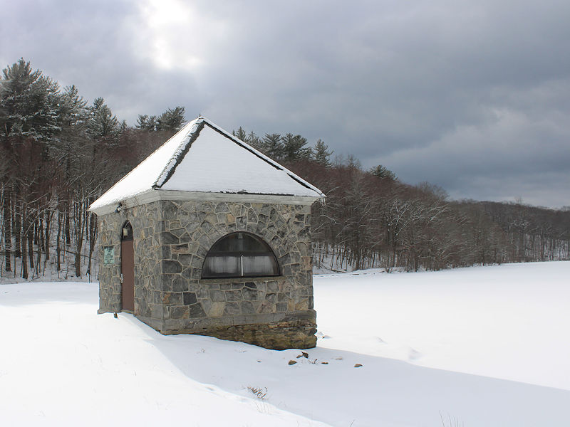
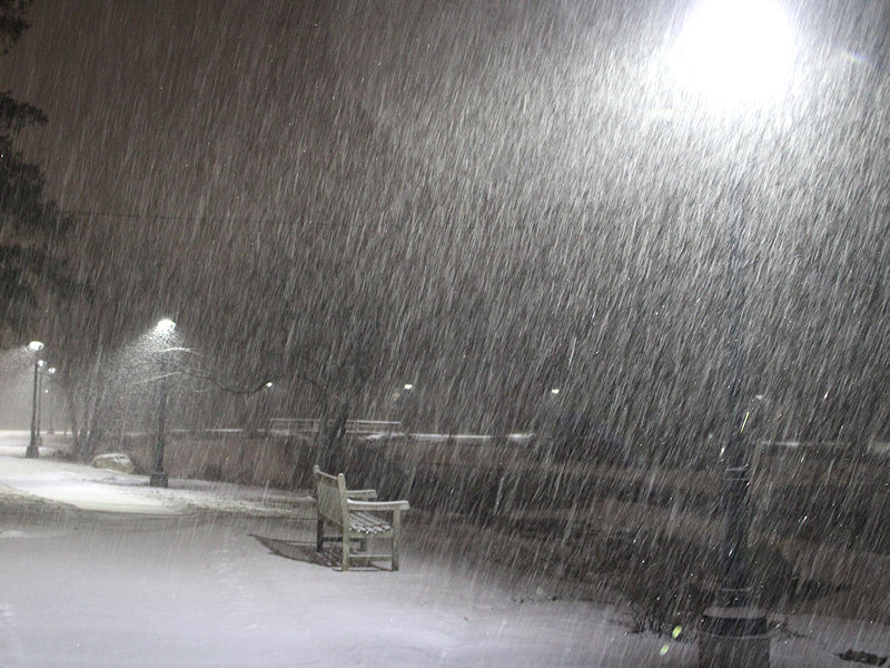
Light snow in Larchmont. The ground is dusted.
-
Yes. We’ll have to see how things play out.
-
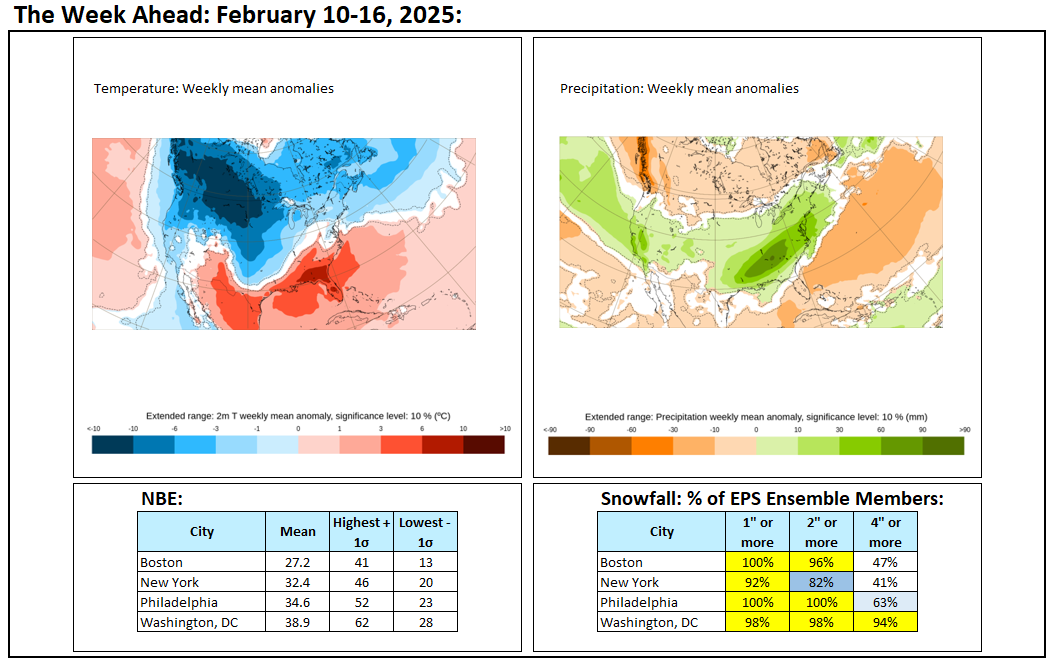
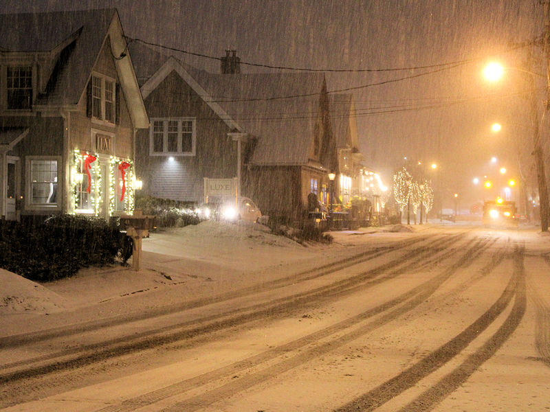
Snow and/or sleet will move into Newark and then New York City between 6:30 pm and 8:00 pm. The snow will mix with and then change to sleet, freezing rain, and the rain overnight. Staten Island, Queens, and Brooklyn will likely pick up 1"-3" of snow. Manhattan, Bronx, and New York City's nearby northern suburbs will likely see 2"-4" of snow. Areas well to the north and west of New York City will pick up 4"-8" with a few locally higher amounts. Another storm could affect the region during the middle of next week. Its exact track will be crucial to determining whether the region is merely grazed by the storm with a light accumulation or experiences a moderate to perhaps significant snowfall. Currently, the former scenario appears to be the more likely one. No exceptional warmth or cold is likely through at least February 14th. A generally colder outcome appears more likely than not during the second half of February. Precipitation will likely be near or somewhat above normal. The AO has now gone negative. However, the NAO is likely to remain at +1.000 or above through the first 10 days of February. Since 1950, just 1 of 18 (6%) of storms with an NAO of +0.900 or above saw 6" or more snow in New York City. That storm occurred with an AO of -1.769. As a result, prospects for a 6" or above snowstorm in the New York City area will likely be limited through the first 10 days of February. The low probability of a 6" or above snowstorm does not mean that there cannot be snowfall or that there won't be snowfall. Smaller events are possible, as occurred on February 2 and February 6. After February 10th, there could be a window of opportunity for a larger event, possibly 6" or more. The forecast pattern has some similarities with that February 8-9, 1994 when New York City picked up 9.0" of snow, but there are differences. For example, the air mass during 1994 was substantially colder than the one that is forecast for next week. The exact synoptic details will be crucial to the outcome. In general, patterns provide insight into potential for a broad area e.g., the Middle Atlantic region. They do not provide details for specific locations within the region. Synoptic details determine whether the potential is realized and how specific locations are impacted. The ENSO Region 1+2 anomaly was -0.6°C and the Region 3.4 anomaly was -0.8°C for the week centered around January 29. For the past six weeks, the ENSO Region 1+2 anomaly has averaged -0.13°C and the ENSO Region 3.4 anomaly has averaged -0.63°C. La Niña conditions are underway and will likely persist into the start of spring. The SOI was +27.33 today. The preliminary Arctic Oscillation (AO) was -1.126 today. Based on sensitivity analysis applied to the latest guidance, there is an implied 82% probability that New York City will have a colder than normal February (1991-2020 normal). February will likely finish with a mean temperature near 32.9° (3.0° below normal).
-
The earlier forecast discussion likely explains their thinking: As the low slides south of the area, its proximity to the coast will determine how quickly the rate of precipitation decreases or any mix or change over of precipitation types occurs. Models still have uncertainty in the strength of a warm layer which would result in changing p-types. Generally the thinking is that after the strongest forcing pushes east after midnight, drying aloft will be able to limit both the intensity of the precipitation and also possibly limit ice nuclei in the column. This combined with the potential warm nose moving over the area may result in a mix with sleet and possibly freezing rain where the warm nose is strongest, more likely near the coast, though possible even for the Lower Hudson Valley and southern Connecticut. Any mix of p-types would limit snowfall totals. A mix in with plain rain is possible mainly for the NYC metro and Long Island as the precipitation intensity decreases if surface temperatures warm to just above freezing, though much of the bulk of the precipitation would have already occurred by this point, mainly in the form of snow or a snow/sleet mix.
-
The timing of the onset of events isn’t very precise. The start of warnings, watches and advisories consider the uncertainty related to timing.
-
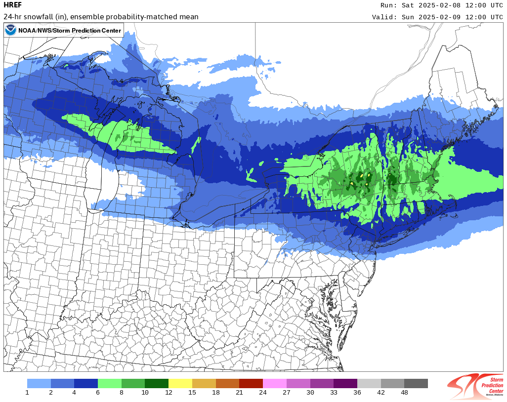
No. It assigns precipitation type based on the top of the hour, so some mixed precipitation can be included, which can overstate snowfall estimates. Usually, I assume one category lower when there is mixed precipitation events such as what is likely this time around. The site is freely available at: https://www.spc.noaa.gov/exper/href/
-
The 12z RGEM largely held its ground. It actually increased amounts in and around the City.