donsutherland1
-
Posts
23,987 -
Joined
Content Type
Profiles
Blogs
Forums
American Weather
Media Demo
Store
Gallery
Everything posted by donsutherland1
-
There was at least some heavy snow in the New York City area, but the biggest snows were in New England. Heavy snow reached New York City and Boston by the early morning of February 22. The blizzard intensified in southern New England, dropping 18 inches on Hamden, Connecticut.
-
It's really impressive.
-
Yes. Reed Timmer's group.
-
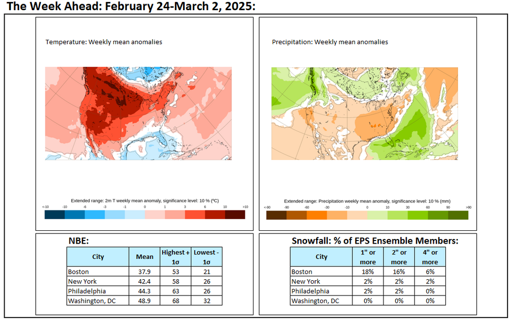
The week ahead outlook:
-
The thermometer topped out at 39° today in Central Park. It will turn even milder tomorrow with the temperature reaching or exceeding 40°. This milder weather will then continue all of next week. The middle of next week could become quite mild with the mercury reaching 50° or above in New York City. Washington, DC could see highs reach 60° or above. Afterward, high temperatures will cool somewhat to the middle and upper 40s to end February. No meaningful threats for a moderate or larger snowfall in the New York City area are likely through the remainder of February. There remain indications that a major pattern re-alignment could take place starting in the first week of March bringing an end to a persistently cold regime that has predominated through most of the winter. The pattern change will likely follow a brief but fairly sharp cold shot. A powerful PNA ridge is currently in place. Historical experience suggests that the presence of such a ridge at this time of year has been followed by the absence of major snowfalls in the New York City area. The PNA reached +1.500 on February 19th and currently stands at +1.750. In all 12 years that saw the PNA reach +1.500 or above on February 15 or later since 1950, the remainder of winter saw no 10" or greater snowstorms. If historic experience holds true yet again, that would make the Winter 2024-2025 the fourth consecutive winter without a 10" or above snowstorm in New York City. The last time that happened was during Winter 2016-2017 through Winter 2019-2020. Most of the 12 winters cited above went on to see some additional measurable snowfall with a few seeing a 6"+ storm. The ENSO Region 1+2 anomaly was +0.9°C and the Region 3.4 anomaly was -0.3°C for the week centered around February 12. For the past six weeks, the ENSO Region 1+2 anomaly has averaged +0.03°C and the ENSO Region 3.4 anomaly has averaged -0.65°C. La Niña conditions have peaked and are beginning to fade. La Niña conditions will likely persist into the start of spring. The SOI was +1.30 today. The preliminary Arctic Oscillation (AO) was +1.502 today. Based on sensitivity analysis applied to the latest guidance, there is an implied 93% probability that New York City will have a colder than normal February (1991-2020 normal). February will likely finish with a mean temperature near 33.9° (2.0° below normal).
-
Some updates on last week’s thoughts: 1. A storm brought moderate to significant precipitation to the northeastern U.S. during February 15-16. Precipitation amounts included: Albany: 1.08”; Boston: 1.79”; New York City: 1.08”; and, Philadelphia: 0.94”. Philadelphia saw somewhat less precipitation than the 1”-2” cited. 2. The February 17-21 period was much colder than normal in Des Moines, Kansas City, and Omaha. Their respective anomalies were: Des Moines: 26.4° below normal; Kansas City: 29.9° below normal; and, Omaha: -30.8° below normal . The coldest temperatures in those three cities were: Des Moines: -11°; Kansas City: -10° on February 20 (old record: 2°, 1918; Kansas City also set a daily record of -4° on February 19); and, Omaha: -15° on February 20 (old record: -11°, 1918). Chicago had a low temperature of -5° on February 18. The last time Chicago saw a temperature at least as cold during the second half of February was February 28, 2015 the temperature fell to -10°. In addition, Bismarck had a low temperature of -39° on February 18 (old record: -37°, 1910). That was Bismarck’s coldest temperature since January 15, 2009 when the thermometer dipped to -44°. Bismarck recorded lows of -35° on February 17 and -39° on February 18. The last time Bismarck had two low temperatures of -30° or colder during the second half of February was 1936 when the city saw two consecutive lows below -40°. Bismarck’s high temperature of -11° on February 17 was the coldest high temperature during the second half of February since February 18, 1966 when the temperature also topped out at -11°. 3. A significant (6” or more) snowstorm blanketed the Lower Mid-Atlantic Region during February 19-20. The significant snowfall was confined to parts of North Carolina and southeast Virginia. Norfolk picked up 11.0”, its biggest snowfall since December 26-27, 2010 when 13.4” accumulated. Significant snow is possible but not assured in Baltimore, Philadelphia, and New York City. As is frequently the case when Norfolk picks up 10” or more snow, cities such as Baltimore (Trace); New York (0.4”), Philadelphia (0.1”), and Washington (0.1”) picked up less than 1” of snow. Three Thoughts Going Forward: 1. Saturday night through Sunday will see a significant rainfall in parts of eastern Texas. 1”-3” of rain is likely in Galveston and Houston. 2. The Southwest will see much warmer than normal conditions from Monday through Friday. Phoenix and Tucson could see their highest temperatures so far this year. The temperature could approach or reach record levels on February 26-27 in both Phoenix and Tucson. Phoenix will likely see its first 90° readings this year. 3. No significant (6” or above) snowstorms are likely from Washington, DC to Boston or in the major Great Lakes cities (Chicago, Detroit, Indianapolis, Milwaukee, and Toronto). Longer-Range: There are growing indications that a significant pattern realignment could occur in early March, possibly preceded by a fairly sharp cold shot. Note: With winter coming to an end on February 28, this will be the last regular weekly post in this thread. The post will be verified.
-
The coldest weather of this month is now moving into the past. It will turn milder late in the weekend. This milder weather will then continue next week. The middle of next week could become quite mild with the mercury reaching 50° or above in New York City. Washington, DC could see highs reach 60° or above. There remain indications that a major pattern re-alignment could take place starting in the first week of March bringing an end to a persistently cold regime that has predominated through most of the winter. The pattern change will likely follow a brief but fairly sharp cold shot. A powerful PNA ridge is currently in place. Historical experience suggests that the presence of such a ridge at this time of year has been followed by the absence of major snowfalls in the New York City area. The PNA reached +1.500 on February 19th and currently stands at +1.776. In all 12 years that saw the PNA reach +1.500 or above on February 15 or later since 1950, the remainder of winter saw no 10" or greater snowstorms. If historic experience holds true yet again, that would make the Winter 2024-2025 the fourth consecutive winter without a 10" or above snowstorm in New York City. The last time that happened was during Winter 2016-2017 through Winter 2019-2020. Most of the 12 winters cited above went on to see some additional measurable snowfall with a few seeing a 6"+ storm. The ENSO Region 1+2 anomaly was +0.9°C and the Region 3.4 anomaly was -0.3°C for the week centered around February 12. For the past six weeks, the ENSO Region 1+2 anomaly has averaged +0.03°C and the ENSO Region 3.4 anomaly has averaged -0.65°C. La Niña conditions have peaked and are beginning to fade. La Niña conditions will likely persist into the start of spring. The SOI was -5.24 today. The preliminary Arctic Oscillation (AO) was +0.800 today. Based on sensitivity analysis applied to the latest guidance, there is an implied 95% probability that New York City will have a colder than normal February (1991-2020 normal). February will likely finish with a mean temperature near 33.7° (2.2° below normal).
-
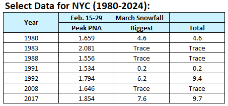
At present, I believe it's premature to highlight potential for winter storms in New York City in the long-range at this time of year with much degree of accuracy, especially as one big factor suggests otherwise. Additional measurable snow this season still seems reasonably likely. My lack of confidence concerns significant (6"+) or major (10"+) snowstorms in the New York City area. In the heart of winter, from January through the first two weeks of February, nature follows a reasonably clear script. When the Arctic Oscillation turns negative (AO-) and the Pacific-North American pattern trends positive (PNA+), the stage is set for snowfall in the New York City area. The likelihood of significant or major snowstorms is well above climatology during such patterns except when the AO plunges beyond -3.000 in January due to January's long wavelengths. To proactively address common misperceptions of patterns, it is important to know what patterns can and cannot do. In general, patterns provide insight into potential for a broad area e.g., the Middle Atlantic region, 5-7 days in advance. They can alert one to look for the potential of an event. However, patterns cannot provide details for specific locations within the region. Synoptic details determine whether the potential is realized and how specific locations are impacted. Winter 2024-2025 was no exception. During January 1 through February 14, an AO-/PNA+ pattern prevailed on 58% of days. However, those 58% of days accounted for 88% of days with measurable snowfall and 88% of total snowfall during this period, including New York City's biggest snowstorm (3.1"). Those days also saw Washington, DC and Baltimore get blanketed by a 6"+ snowstorm. But as the calendar passes mid-February, the storyline shifts. During the second half of February, the most formidable snow events tend to arise from a different combination: AO-/PNA-. A PNA+ often leads to suppression in the realm of late February's shortening wave lengths when the AO is negative. The recent snowstorm that brought 11.0" to Norfolk was the latest such example. Even worse, when PNA+ ridges grow too strong during the second half of February—pushing to +1.500 or above—they often play the role of a harsh gatekeeper, shutting the door on any chance of a major snowstorm for the rest of the snow season in the New York City area. Winter 2024-2025 will again challenge that "gatekeeper." In the 12 previous cases since 1950, New York City saw no major snowstorms once the PNA reached +1.500 during the February 15-29 period. Time will tell whether Winter 2024-2025 has a different outcome. Then comes March, and the narrative dissolves into uncertainty. There is no longer any dominant pattern. Even as a positive North Atlantic Oscillation (NAO+) has been present during six of New York City’s seven snowstorms of 6 inches or more during March 1-15 since 1950, the sample size is too small to trust the pattern fully. As the calendar advances beyond mid-March, the potential insight offered by large-scale patterns vanishes almost entirely. Now, it’s all about the fleeting, unpredictable nature of shortwaves and the dwindling reservoirs of cold air left to tap. Forecasting at this point becomes a high-stakes waiting game. Chasing shortwaves 5+ days out is like chasing shadows. Models don't become highly skillful with synoptic details until 1-3 days out. Sometimes they struggle within even this period.
-
All seasonal snowfall is included.
-
Seasonal snowfall through February 20th: JFK: 12.0" LGA: 15.4" NYC: 12.9"
-
It's close on the scale I use, because cold and snow are weighted equally. 1982-83 was much warmer than the current winter.
-
Yes, I agree with you.
-
So far, this winter has been colder and snowier than Winter 1988-89 and somewhat colder but somewhat less snowy than Winter 1989-90. It ranks better than both those winters.
-
I enjoyed every little snowfall, too.
-
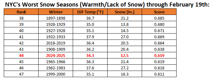
I will post the final rankings at the end of the season. Here's where things stood as of yesterday: 2024-2025 was marginally worse than 1965-1966. 2024-2025 was the worst ranked winter with a mean temperature to date of 34.3° or below.
-
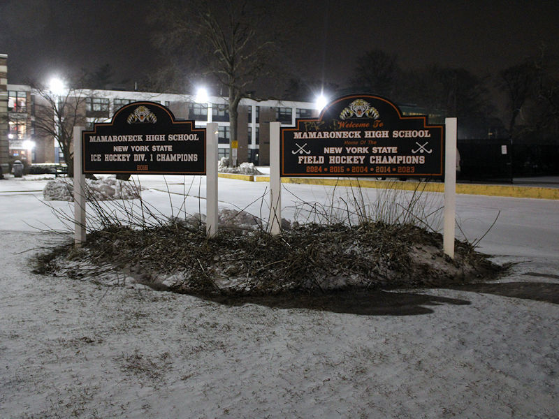
Two photos from Mamaroneck. Light snow continues to fall, but there's not much fluff to the snow and it is barely accumulating.
-
I fully expect that Central Park will record measurable snow when the final report is posted. In the Bronx, there was a solid coating of snow this evening. Earlier, there seemed to be a similar coating based on the Columbus Circle webcam.
-
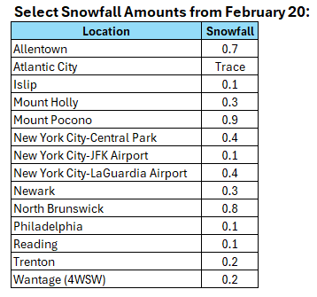
A storm passing well south and east of New York City produced a significant snowfall in parts of the lower Middle Atlantic region yesterday into today. Some 12" or above amounts were recorded in the the Portsmouth and Virginia Beach areas, as well as parts of North Carolina. 1 SSE Macons Corner, VA picked up 13.0" of snow. 2 NNW Currituck, NC received 14.0" of snow. Snowfall amounts included: Norfolk: 11.0" Raleigh: 2.6" Richmond: 4.0" Washington, DC: 0.1" Norfolk has now received 16.8" of snow this winter. That makes Winter 2024-2025 its snowiest winter since Winter 2010-2011 when 21.2" fell. A period of light snow or flurries from the associated upper low will bring a coating to 0.5" of snow in and around New York City. Somewhat higher amounts are possible from central New Jersey southward and across eastern Suffolk County. It will turn milder late in the weekend and the milder weather will continue next week. There remain indications that a major pattern re-alignment could take place starting in the first week of March. The ENSO Region 1+2 anomaly was +0.9°C and the Region 3.4 anomaly was -0.3°C for the week centered around February 12. For the past six weeks, the ENSO Region 1+2 anomaly has averaged +0.03°C and the ENSO Region 3.4 anomaly has averaged -0.65°C. La Niña conditions have peaked and are beginning to fade. La Niña conditions will likely persist into the start of spring. The SOI was -11.77 yesterday. The preliminary Arctic Oscillation (AO) was -0.414 today. Based on sensitivity analysis applied to the latest guidance, there is an implied 94% probability that New York City will have a colder than normal February (1991-2020 normal). February will likely finish with a mean temperature near 33.6° (2.3° below normal).
-
As per mPING, there is some snow falling in the Lehigh Valley. It's not all virga.
-
Today, the preliminary PNA value is +1.663. Since 1980, there have been seven years where the PNA reached +1.500 or above during the February 15-29 period. Those cases did not feature any major snowstorms during March. Moreover, during the second half of February, strongly positive PNA regimes do not favor major snowstorms. Indeed, New York City received no 10" or greater snowstorms when the PNA was +1.000 or above during the second half of February through the remainder of the snow season (1950-2024). All said, given the lack of model support for its solution and the historic data concerning strongly positive PNA events at this time of year, the 2/20 12z GGEM solution is very unlikely to verify. This does not mean that there can't be any snowfall for the remainder of this month or during March. It just means that major events are unlikely. There were some significant snowfalls (6"+), so that might be about the top end of what could reasonably be expected. As always, sample size considerations and the low probability of an exceptional event can't be ruled out. But unless there is strong and consistent evidence for such an event, one should be skeptical about outlier model solutions such as that which was shown on this morning's GGEM run.
-
It happened even sooner than I could respond.
-
So far, Bayside, VA has seen 8.0" of snow.
-
A storm passing well south and east of New York City will bring a significant snowfall to parts of the lower Middle Atlantic region tonight into tomorrow. Snowfall estimates: Norfolk: 6"-12" Raleigh: 1"-3" Richmond: 3"-6" A period of light snow or flurries is still possible in the New York City area from the associated upper-level low. The light snow event could bring a coating to a half-inch of snow. Somewhat higher amounts are possible from central New Jersey southward and across eastern Suffolk County. Overall, generally colder outcome is likely during the second half of February. Precipitation will likely be near or somewhat above normal. However, there are growing indications for a major pattern shift during the first week of March. Some of the guidance begins to break down the pattern in the closing days of February. The CFSv2 is currently a cold outlier. The ENSO Region 1+2 anomaly was +0.9°C and the Region 3.4 anomaly was -0.3°C for the week centered around February 12. For the past six weeks, the ENSO Region 1+2 anomaly has averaged +0.03°C and the ENSO Region 3.4 anomaly has averaged -0.65°C. La Niña conditions have peaked and are beginning to fade. La Niña conditions will likely persist into the start of spring. The SOI was -16.91 yesterday. The preliminary Arctic Oscillation (AO) was -2.306 today. Based on sensitivity analysis applied to the latest guidance, there is an implied 92% probability that New York City will have a colder than normal February (1991-2020 normal). February will likely finish with a mean temperature near 33.4° (2.5° below normal).