

Jackstraw
-
Posts
2,590 -
Joined
-
Last visited
Content Type
Profiles
Blogs
Forums
American Weather
Media Demo
Store
Gallery
Everything posted by Jackstraw
-
4 here so far. Fun dog snow lol
-
Had SN to +SN of the Hallmark variety for about 3 hours. Currently -SN with 2.5 inches of new powder so far. Gonna be weenie banding it until about 9 or 10 then we'll see if that batch in Central IL can ride through here. Thats the fgen band that could bring another 2 to 4 here. South Central IN cashing in too from plow cameras. Just like this past weekend what fails for some is cash for others
-
Solid SN here with vis down to 1/2 mile. Nice weenie band approaching
-
These are the kind that can jump out and "scare" someone with an unexpected 6 inches. Certainly will give the rest of us a chance to pack match the last systems winners lol. Load me up with chips, I'm calling 4 for here!
-
Had a 48mph gust at my station early this morning. While it was breezy pre-frontal that front/wind shift from the S to the W was abrupt, like in 5 min, and hit like a freight train with consistent gusts over 45mph. Woke me and the dog up lol.
-

Nov 28-30th Post Turkey Day Winter Storm
Jackstraw replied to Chicago Storm's topic in Lakes/Ohio Valley
Got 5 I'll call it to stay consistent with reports from around the area. Would have been a total bust if not for that late morning punch where we got half of that. Had nearly an 8-9 hour stretch with nothing in between. Both bookend periods were of higher quality powder than I expected. Lost an inch or so due to some melting, compaction and a small bit of drizzle around 3am. Got Pingers too for good measure lol. Not my best Nov snow but a top 5 in the last 15 years since I've been here. Sadly Nov '25 has tied my entire winter last year. Congrats to the final table up N and good luck to all over the next week. Me thinks a Dec warm up is not far away. Hopefully we are timing out for good holiday systems this year! -
Nov 28-30th Post Turkey Day Winter Storm
Jackstraw replied to Chicago Storm's topic in Lakes/Ohio Valley
Got some confirmed pingers on the windows! lol. Now, get some freezing rain and that'll fill the kitchen sink -
Nov 28-30th Post Turkey Day Winter Storm
Jackstraw replied to Chicago Storm's topic in Lakes/Ohio Valley
Rip city finally. Giant PacMan of dry Easterlies been eating every weenie band trying to get here to Kitchen Sink Canyon. Wiped 2.5in off the board at 1 and zero, nada, zilch until now. We'll see how long this lasts. Winds are finally getting a southerly component letting some moisture in. Think its gonna be too dry for any liquid at all if the temps do climb above 33 or 34 around midnight or later. Gonna have to buy in 3 or 4 inches on the next draw at this rate. Went 6 inches all in with a pair of Jacks in the hole lol. Loved all the pics from the bright side! -
Winter 2025-26 Medium/Long Range Discussion
Jackstraw replied to michsnowfreak's topic in Lakes/Ohio Valley
I know this Chitowncentric board is focused on tomorrow but the signal of a possible App runner coming up from the S behind this one and partially phasing with some northern stream energy in the Tues to Wed timeframe is gaining a little support with the models. Would be a nice to substantial stat padder for most of the sub and get folks to the S (ILL/IN) and E(OH) that will whiff tomorrow in on a pretty decent early season snowpack that could be around until at least through the weekend. Might be thread worthy if models keep trending up (mainly the stingy fickle Euro). Staying positive as long as I can lol. -
Nov 28-30th Post Turkey Day Winter Storm
Jackstraw replied to Chicago Storm's topic in Lakes/Ohio Valley
Best disco for those of us on the southern edge. Shallow warm layers in these setups tend to produce little liquid. Takes a little more umph/depth in temp rise right along the transition to produce more robust liquid, especially with a fresh snow pack preceding. I've rarely seen more than light drizzle in setups like these, better chances of a full light or heavier rain switch with temps above 34 and at least a +freezing 850 nose to help. Not saying it cant but this setup is half my winters lately. Now where and how long does it last? Starting to call my area Kitchen Sink Canyon lol -
Nov 28-30th Post Turkey Day Winter Storm
Jackstraw replied to Chicago Storm's topic in Lakes/Ohio Valley
Watch out for those COD snow maps, their algorithm ain't right. Go with pivotal snow maps. Also 10/1 gonna be closer to reality. Might go Kuchera on anything past early Sunday morning (if it's there) and next week. Like I said on my call I'm literally still on the make or break line lol ( kitchen sink climo for these slow cutters). For the record the Ukie and the Canuk have been the most consistent in their forecast the last 60 hours or so. Whether they verify well.... KIND calling for roughly 3-5 here but 2 miles to my N IWX is calling for 4-8 Iol. Sticking to my guns on my 6" call as we tend to underperform by a bit or overperform by a lot in these setups where the low tracks just to the NW by the southern lake yet there's decent antecedent cold air in place prior. While I think we may get some liquid I thing it may only be a couple hundredths of drizzle at most. This is a setup where a dry slot could be my friend. Think I'm in good spot to avoid a rainer chaser. Sub surface ground temps around my property are just above freezing in full sun so I dont think there will be a lot of melting but there could certainly be a little bit. Wipe the board properly when measuring and compaction dont count in a total! Regardless it looks like Nov '25 will beat my entire winter last year which is really BAD! lol. I think you, Kokomo and even Tipton in a lot better shape. As it says in Stebo's comment in my sig, I'm a bird fart away from warning snows or slushy mud-cicles lol. Good luck! -
Nov 28-30th Post Turkey Day Winter Storm
Jackstraw replied to Chicago Storm's topic in Lakes/Ohio Valley
This things gonna cut right over me. Will literally be 5 mile shift in track that we could get warning criteria snow or 3in of slush. KIND rather bullish on warning criteria just to my west with the question mark right on top here as usual lol. White knuckle weekend ahead, pun intended. Go big or go home, I'll call 6in here. lol -
Nov 28-30th Post Turkey Day Winter Storm
Jackstraw replied to Chicago Storm's topic in Lakes/Ohio Valley
Everyone who gets it enjoy! I'm half way to last years season total so I've got all winter to get 4 pathetic more inches lol. Seriously, this is a good start to Met Winter as long as it doesn't catch the lane right before the pins. I expect kitchen sink variety this time of year here. But this year is feeling like a doozie of a winter coming. This damn rubber band has to snap at some point Note: There, I jinxed myself -
Fall 2025 Medium/Long Range Discussion
Jackstraw replied to Chicago Storm's topic in Lakes/Ohio Valley
I know I am lol. Havent seen a fantasy run like that for my area in a loooong time for late Nov/early Dec -
My climo isn't exactly December friendly but lately winter isn't friendly period. That snow the first week of this month was half of my total last year. That ain't climo, that's just stupid lol
-
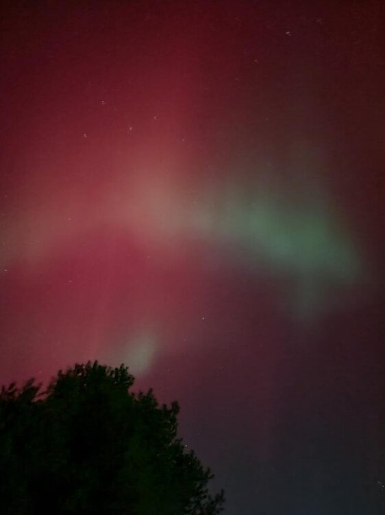
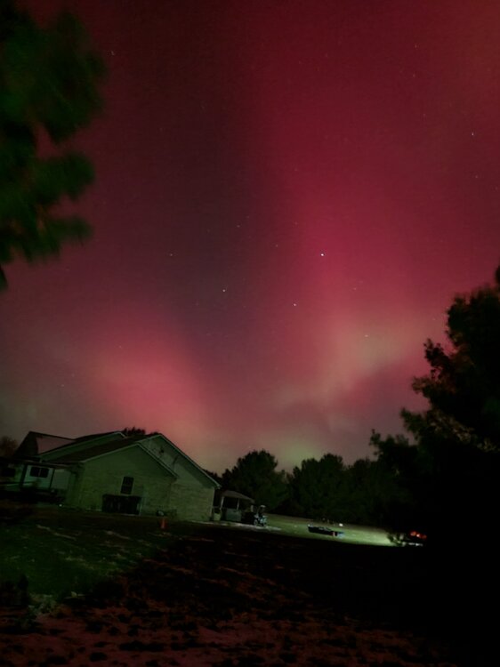
-
That was the best Aurora ever for me down here!
-
11/8-11/10 First Snow and Lake Effect Event
Jackstraw replied to Geoboy645's topic in Lakes/Ohio Valley
Leaves are covering the snow here. That's pretty funny. Snow plows and leaf blowers lol. Great Sat loop of the Great Lakes as the upper low recedes to the S revealing the extent of it's early season cover.... https://www.star.nesdis.noaa.gov/GOES/sector_band.php?sat=G19§or=cgl&band=GEOCOLOR&length=12 -
11/8-11/10 First Snow and Lake Effect Event
Jackstraw replied to Geoboy645's topic in Lakes/Ohio Valley
2in here and still moderate sugar falling. Last short cut of the grass paid off lol. Roads are covered so it got cold enough for sure. A bit surprised. Wasn't expecting this much this far S but hell, I'll take it. Have fun up there! -
Hopefully it's a trendsetter
-
Easter lol
-
I usually leave my grass 4-5 inches tall for winter. After last year I may cut it down to 1 inch for a better chance that I get full coverage this winter lol.
-
Yeah thats about what we got from this last system. Threaded the needle N and S big time. With no measurable precip until fantasy range on the models here's to hoping the precip rubber band bounces back with sub freezing temps and as snow! Buddah knows, after last winter, we are way overdue for a bomb storm this coming winter!
-
Well this slowly growing older man finally broke down and built a new PC. I do my PC's like my cars, I drive them until thewy smoke lol. Built a PC and bought a laptop in 2009 cost me 3500 bucks. I future proofed them best I could and well, its been nice but time to move on. They'll make good Linux machines. I was completely blown away by how damn confusing (and expensive) it was to build a new PC today. I was in IT for 30 years and I've never seen a market like this since the 90's. I think all of these companies paid billions on marketers and only spent 100's on engineers. I tested some real stupid components with some really flashy light thingy's and all kinds of wiz bangs that didn't amount to crap lol. There is so much marketing BS, especially graphics cards (what a freaking insane rip off!) I was in over my head instantly. All I got to say is if anyone else does it good luck. Researching through all the BS is a royal pain. It's worse than car salesman. If you don't do your research you can end up spending 3 or 4k bucks when you can build one that is 90% of one of those for less than a 1k bucks and will last 10 years. Took me 3 months just to research and test this marketing garbage lol. Got it done. Whew!
-
Well Fall is my favorite time of year. I could care less about the colors but its the feeling in the air when that first big front rolls through and triggers the seasonal change. There's just a feeling in the air as we move through October up to Thanksgiving. The sound of leaves blowing, crunching under the feet as you stroll through the woods. Out in the country (where I live) suddenly opens up as they harvest and you forget how far you could see after a few months of being surrounded by crops. The woods too suddenly open up. Its great just to get in the woods as or after the leaves fall as you can really see all the wildlife getting ready for winter. It's also a great time to canoe or kayak. Ill be heading to Turkey Run State park area to go canoeing. Canoeing or kayaking down rivers in the Fall is the best (so's the fishing). A lot of this comes from when I was young. My grandfather had a 5 acre garden that we harvested by hand for his veggie stand. The smell of my grandmother canning veggies in October. There are certain spices used more when cooking in the fall. Very distinct smell when your around someone that cooks from the land and not a store. Working out in the giant garden in the early morning with coats on then peeling off layers as the day progressed. There's a smell that plants release when your picking, can't describe it. Those insanely long times of daylight starting to decrease at an ever growing pace. I always notice that more in Fall than in Spring. It's another sign of what's coming. It's anticipation which is a great feeling. If you're locked up in a city yeah it sux. Get the hell out and go someplace where you can enjoy it. I also enjoy it because it's the first hint of what could come, my second favorite time of year winter. Anyway Fall is about a lot more than colors. It's in our genes. It's in our instincts. It's the beginning of a celebration as we get ready for another trip around that big ball of light. Yeah, a lot more than colors... to me anyway.


