Jackstraw
-
Posts
2,590 -
Joined
-
Last visited
Content Type
Profiles
Blogs
Forums
American Weather
Media Demo
Store
Gallery
Everything posted by Jackstraw
-
All this rain we've had over the last 6 weeks or so and the UFO landing pa... I mean Pixie rings are every where, and I mean everywhere. More than one would usually see around here. If I start hearing crickets chirping Irish jigs I'm gonna start drinking again lol
-
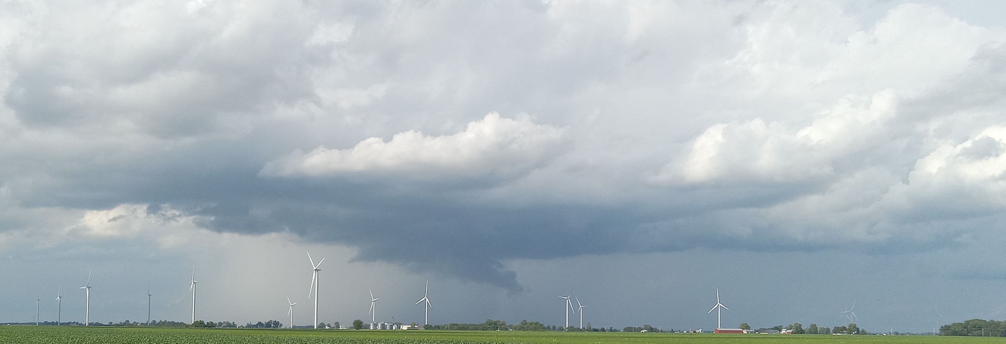
Seems like there's a pop up around here every day. Another one this morning, just popped up and dropped another quarter of an inch. I'm at 27 inches or so since 3/1 in my gauge. With models toying around with anywhere from 2-5in's in the next 10 days or so I could be over 30 inches of non tropical storm rain by the end of July. That's getting close to a years worth of liquid. Crops are definitely having their usual effect on low level humidity levels keeping dews in the 70-80% range. These night time dews in the 80% range can be suffocating even with overnight lows in the upper 60's to 70. Your body has nowhere to transfer the heat except a sweat rag lol. It's also hard on these crops. Mold issues are exploding. Field sprayers have been out in force trying to rescue a severely shunted soybean crop around here this year. Could get our first real shot at some swamp weather coming North next week. Models are really trying to roll in some South Calalacky crap next week with 90's, rain. and dews approaching 90% at night. Yeah, that's why they OD on Ice Tea down there, and beer lol. This has been one of the most humid, damp, muggy summers I've experienced since I moved back so far.
-
Dammit, was going to go RC flying today but we're suddenly getting some wind. It's only 15KTs but thats too windy for me to risk my old 48in balsa wood Pitts I built with my son back in the early 90's. I would cry if I pile drove that thing into the ground lol. It's full aerobatic and a bitch to get up in the air (and back down!) but once up this thing can scream over 100mph in a dive. Rated at 20G's (pretty high for doped wood) and I've accidentally pulled 30g's with it while missing the bottom of a loop and saving it with less than a foot to spare. I haven't flown it yet this summer which is rare, I've usually had it out by now. I need nice calm wind to fly it in and haven't had it yet (at least not when I had time to fly). If it was more modern foam or composite like some of my others no big deal. But if you've ever built a balsa flyer re-building one sucks! My son won with it in a couple of straight aerobatic contests (not that vertical dancing BS) down in FL. It's still a little bad ass flying weedeater. I'm going to try again tomorrow, I'll post some pics, I just took it apart and travel packed it. I might go to RC Park nearby tomorrow if the winds good.
-

2025 Short Range Severe Weather Discussion
Jackstraw replied to Chicago Storm's topic in Lakes/Ohio Valley
Confirmed very small and brief "tornado" in southern IN this morning. I'm a dunce. I had never heard of an EFU rating lol. https://www.weather.gov/ind/July16thTOR -
FrankenKorn doing it's thing. It blows me away how fast this high fructose fat machine of a plant grows today. I swear, on a quiet evening on the porch I can hear it growing lol.
-
Ditto. I try to explain to people around here what it's like down there, especially inland. They just don't understand that you can actually adapt to it. I had people from here come down to vacation for a week and leave after 3 days lmao. I couldn't figure out why every one moved so slow down there when I first moved there from FL (beach FL mind you with life saving sea breezes). I mean it is very noticeable they move at a different pace in the low country. Then the full force of summer hit, for like 5 months, and I got it lol. I started calling it slow country instead of low country.
-
It will be really nice to get a perfectly timed pop up storm in this pattern to give a quick cool down and have one enjoyable (moderately anyway) evening. This 80 degrees at midnight crap is still giving me flashbacks. Anything after 6. Anything earlier would suck. They need to come out for localized advisory's for early-mid afternoon showers in this setup. Something like an Emergency Sauna Advisory lol.
-
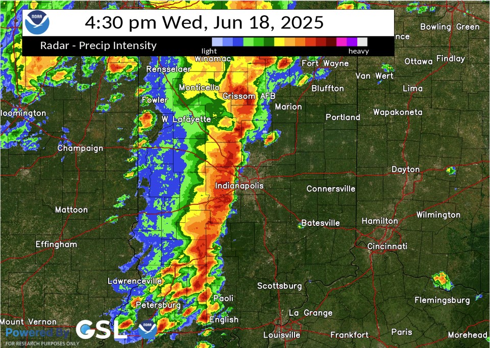
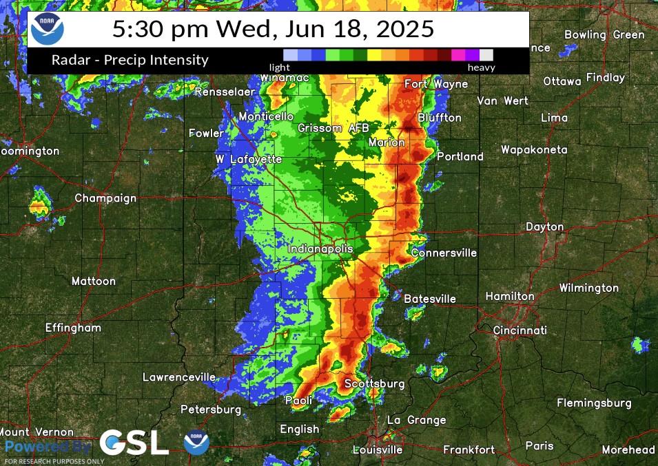
Well the tree and power line trucks are gone. I swear you'd have thought we got hit by a hurricane by as many of them that were all over this area until yesterday. Took a drive over the weekend and it was pretty bad for the trees, big trees, I mean 2-3 footers, 6in-1ft limbs down everywhere. From my previous hurricane life conditions were similar to a slow approaching hurricane as the specific area around me was hammered with up to a half foot of rain so we were already flooding when that line hit. That meant the trees and the ground were pre-soaked and primed to fall if there were strong enough winds and there were. Easily close to 1 min sustained strong TS force with Cat 1, maybe Cat 2 gusts through that area. Eerily similar to how widespread tree damage is caused along the coast in strong TS's/weak Hurricanes only without a storm surge. Been awhile since I've seen that much widespread tree damage around here, especially central Madison over into Delaware and Blackford counties. Along with the gusting "almost a D word" line there was also a significant downburst, IMO, through that area as a pre-frontal cell that blew up ahead of that line was consumed within it. You can see it in these 2 radar images from KIND's event page. The first Image, its in front of the main line as it was blowing up just SW of Marion and the second, you can almost see the exact shape of it embedded within the line just ENE of its previous position almost directly S of Marion. What was even more interesting, to me anyway, was a very small ragged "donut hole" type feature immediately behind it. That "donut hole" artifact or whatever it was passed right over my position where I nearly hit a tree as it came down. I don't think its radar shadowing or anything like you would see during a hurricane. I really think, IMO, its a radar image of a downburst or microburst (are there Sting Jets in severe lines?lol) from or enhanced by that rapidly forming small SUP out ahead, possibly from it collapsing within the line accelerating the forward "gust front" even more. I mean that thing shot up to 55kft in like 20min on Radarscope before the "Meg" line ate it lol. That's why I was chasing it. It had a rapidly lowering wall cloud, a good hail core (2-2.5 inchers reported directly under its position in the Alexandria, Summitville areas) and was just forming a nice tail/hook on radar (you can see that a bit in the first image). Back flow was ramping up into that little SUPs gut as the updraft accelerated. Went from maybe 15 to 20KTs, more parallel flow from the SSW, then suddenly veered to easily 30-35KTs from the SSE as I got about 2 miles S of it. I'm more than likely over analyzing it lol. It more likely the ton of very localized rain that resulted in so many large trees and limbs concentrated in that area as opposed to more spread out in other areas. I counted at least 65 entire trees larger than 2 feet either uprooted or snapped just on my 2 hour drive. North and south, where they didn't get massively presoaked there was not nearly as much concentrated tree damage though. But those radar images kind of puzzled me when KIND put them out Sunday triggering the ADHD non scientist in me One of the stranger storm chases I've done. Wasn't prepared, very chaotic spur of the moment chase looking out the windows, at the radar on the phone at 45 to 50mph on country roads (around Moonville IN, the worst place to chase lol), in and out of densely wooded areas along White River and suddenly dodging falling trees and sideways rain all at the same time lol. Whatever, sorry for the long post, I'm just out of heat therapy but it was nutz lol. (Don't get on me about safety, y'all have done it before lmao) https://www.weather.gov/ind/june182025severe
-
95/75 nearly every day for 5 months is SE US living at it's finest lol. Then break out the giant tiger mosquitos that can drain a pint per bite. The old saying in South Calalacky if you ain't on the coast your toast lol. Usually the first time it gets like that around here I go into a few days of therapy from having flashbacks causing heat trauma related PTSD
-
Here's a pic of it showing a nicely tilted mini updraft mini SUP that shot up to about 50kft with some low hanging fruit lol. It actually spit out some pea size hail, you can see a bit of a "mini hail core" in that pic lol. Had some weak rotation on it. Enough fruit to get some local kids excited out there chasing scud. Some wimpy plains chasing right there lol. Yeah glad it missed us. Hope the ring of fire stays away too next week. My goodness is it gonna get humid around here. Got a feeling the mosquito hatchery is about ready to burst. Still ROFL, Bob Uecker, Ha!!

-
Good thing I just bought new tires yesterday. I was trying to get in front of a small cell in front of the main line of storms that was rotating and had a nice wall cloud on it when the gust front from the line caught me from behind. I mean wind went from 0 to 70 or 80 in a flash. This damn tree came down about 50 yards in front of me as I was going about 45mph. I think my old 10 year old tires would've probably killed me lol. Lots of really big trees, limbs, fences, sheds some roofs and barns blown down between Lapel and Muncie. Really strong microburst downdraft through that area as the trees weren't "blowing" sideways it was the wind blowing the trees actually down towards the ground. You could feel the wind coming down like a hammer. Temp went from 85 to 66 in about 90 seconds. One of the weirdest things I've ever been caught in. I drove home and put my underwear in the washer Got up this morning and we got another 3 in and its still raining. This area is flooded pretty bad.

-
Well just got new tires down in Indy. Time to road test lol Sent from my SM-S134DL using Tapatalk
-
Wouldn't be so bad but its coming in 2 inch shots in 6 hours or less at a time. Gotten a foot over week of fairly steady rain from some tropical drain outs here and it doesnt flood like this. I've watched the radar and we get these heat bubbles in weak flow coming up out of Indy resulting in some fairly deep convective points that have just set on top of us repeatedly and poured. there was another this afternoon but luckily it was down just South of Anderson. Dropped 2 in in 4 hours there. Same type of setup. We've lost 50% of the green space between here and Indy in the last 15 years. They are paving and concreting their way N at a rapid pace. Its really expanding the heat island effect here. Some models spitting out another 1 to 2 inches here by Thursday AM. I hope it comes slow
-
It's starting to get biblical here. Another 2.5in last night. I have serious flood issues now. Creeks over its banks. Waters about 6ft from the back deck. I just dropped 150ft of new fence posts Sun/Mon. Those are damn near floating, gonna have to be redone damn it. Fields around here are drowning. Kinda wacky as its fairly isolated to just this area. 9 inches since Friday. Thats half a summers worth in 4 days. Man the muggles are gonna suck this weekend when we start hitting 90/70 dews. South Carolina low country is chasing me. Had enough of this shit.
-
A little over 6.5 here as since 10am yesterday. Thats a sprinkle where I used to live lol. Looks like the boundary is slowly settling to the ESE. Good thing. We are on the brink of some 50 year flooding in this area. Cant take anymore rain. A lot of fields around here are getting their soybeans drowned. I've got lakes everywhere on my property, but no fish
-
We have been getting pummeled with rain today. 3.5 inches in the gauge and and its still shaking out sheets of rain. Training off of the N Indy to the dreaded Carmel area urban heat island off to the NNE all day. Line came through earlier and it dissipated except the train from N Indy to right over me. It just won't stop. Like the Pacers
-
Man I hate putting dogs down. Gotta 12 year old Newfie and her old hips are finally giving out. Actually she's a Landsear, she looks like a dairy cow (and is damn near as big as one lol). She's getting to the point it takes her 6 or 7 tries to get her ass up. Would never tell if she's in pain. I've heard that dog whimper or whine like 0 times in her life, even as a pup. I've accidentally stepped on her fat foot a few times and she just stares at me like "dumbass". Hit her with a tractor when she chased a rabbit in front of me. Knocked her over, thought I killed her. She just got up, shook it off, not a sound, and looked at me with the "dumbass" look. Her names Red appropriately. Was hoping she'd get to see snow one more time but she's not gonna make it through another summer of heat. Just sucks.
- 170 replies
-
- 13
-

-

-
I love Ireland lol.
-
One BIG very important thing is to make sure that its not the battery keeping it from closing. Older Lithium Ion laptop battery's can swell up and possibly catch fire, especially if they are plugged into AC power for long periods at a time. Pull it out look and feel up and down it, you'll be able to tell. If its swollen get it out of there. You can get refurbished ones for most laptops on Ebay for 20 bucks or less. I've got one like that (am actually typing this on it, kinda). If it's like mine (and not the battery) it's probably got a couple three broken tabs that hold the clam shell together. No easy fix (that I know of) unless you feel comfortable removing the guts and putting them in an identical (if you can find one) clam shell off of Ebay. It's a common "break" on older laptops and isn't a big deal unless you are still very mobile with it. Or you could do what I've done with mine. Mine is the original version of the Intel Core I5 (late '08) and it does the same thing as yours, on 2 sides lol. Hell, half the keys on the keyboard are gone and the screens broken lol. I just put a piece of duct tape (with a small slit to enhance cooling on the old bird) on it to secure it where it pops open. . Mine is plugged via HDMI into my TV with a bluetooth keyboard and mouse on the coffee table. It was my work PC for 10 years. It's been through hell and back including sliding off the top of my car while getting on I95 just N of Savanah GA because I forgot to put it into my bag lol. Scratched up but still fired right up. Still works like a champ to this day even though it's in nearly 16 years old. Takes most anything I throw at it, in it or on it lol (except gaming stuff of course). I'll use it until it smokes. One of the best 2k bucks I ever spent. Old Acer's where rock solid laptops.
-
So I was in a Big Box store today buying dumb stuff I don't need. There was a younger couple in there buying GMO veggie plants for their garden. I'm sure they try and show off to their neighbors, who both probably live in 700k dollar 3 designs, 6 colors available cracker box's in a 200 unit HOA'd subdivision with 3ft trees close enough together the husbands can toss toilet paper back and forth from the bathroom windows and probably plant the exact same genetic hybrid squash, complaining about the weather. I'm also sure (yes I'm sure again) they were driving one of the 50 80k dollar SUV's that crowded the lot (I recently complained about "storm related driving" in the area I just happened to be shopping in, its why I'm sure ). I heard them tell the cashier they lost some plants this year. They always plant 3 weeks before Memorial Day. (WT holy F!! this is Indiana people!!) I had to chuckle to myself. I mean do they not get that Memorial Day is about 2 days earlier every year until it isn't? People like that are why there's GMO tomato plants for sale in July around here lmao.
-
Awesome. Means another $50 dollar electric bill instead of $150.
-
I know I'll take it lol. As a matter of fact I'll take a cool summer even though we're probably gonna have to pay for this weather at some point. I fear the sauna is nigh
-
I said me who lives here not you. Personally I'll take 2 days of potential rain along with 60'-70-/40's-50's for 7-10 days over a damn sauna. And they are backing off of the Wed rain as they always do this far out with E/SE oriented precip . Precip from that direction is usually very light for this area. I should know, I live here
-
I'd like to place an order for this upcoming week to finish out the month please
-
Hell ride omw home from the track. Got stuck on 31 around Carmel with idiots flipping out because sirens were going off. Saw one moron stop in the middle of an 8 lane 65 mph interstate. Those drivers were safer going 240mph than I was. Somebody needs to pass Xanax out to these people for Christs sake. Get off the freaking Interstate, there's exits every half mile for 10 miles in that area. Stressful. Weather was cool though.