Jackstraw
-
Posts
2,590 -
Joined
-
Last visited
Content Type
Profiles
Blogs
Forums
American Weather
Media Demo
Store
Gallery
Everything posted by Jackstraw
-

Pre-Christmas (Dec 21-23rd) Winter Storm Part 2
Jackstraw replied to Chicago Storm's topic in Lakes/Ohio Valley
Snowed started around 4:30 but didn't really start sticking till about 6. Nice big flakes to start but as soon as the wind picked up they shattered. About 2 down with a decent band moving through right now, might give us another inch. -4/-25 with 35mph gust highest I've had on the station here so far. We had a similar storm a few years ago, not quite as cold but gusts to 40 for about 12 hours. It did snow more with that one, around 6 inches. We had 6 foot drifts out here in the boonies. Think the warnings were warranted. Roads are trash out here with the little snow we've gotten. If we would've gotten the forecasted 6-7 the models were spitting out (or more from crack model) it could've been nightmarish. Not quite over but at least a white Xmas, those are hard to come by around here. Merry Merry -
Pre-Christmas (Dec 21-23rd) Winter Storm Part 2
Jackstraw replied to Chicago Storm's topic in Lakes/Ohio Valley
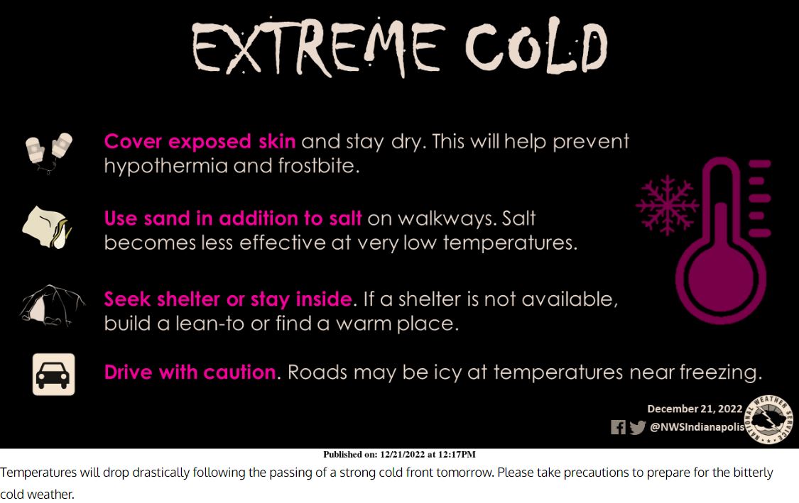
Hats off to KIND for pulling this Daniel Boone era cold weather tip placard out of their butt crack. Glad I brushed up on my lean-to skills this past summer lmao.
-
County was out plowing for about 3 hours here this morning then parked them. X
-
if IDOT cameras worked lol. 31 looks passable but slow up to 38. Cant see farther than that but they did have 4 plows on 28 this morning
-
Plowing is futile around here. Some 4 foot sets in the country. Drifting efficiency is at its max. Storm total 7 so far with 3-4 hours to go per radar trends. 12 is within reach, we shall see.
-
FZ starting in the warned areas. Really hope forecast is overdone
-
Thats a ton of precip heading NE for February
-
00Z Euro not looking good from a suppression standpoint. Repeating my mantra "I know my climo, there's nothing I can do about my climo, I accept my climo". If I need to head SE and get some real Cincinnati chili, not that fake skyline crap, to see more snow I will lol.
-
Very similar here except that bottom layer is just water pooling over frozen ground from 12 hours of rain that flash froze in about 30 or 45 minutes. I know from living in the sticks you drop some powder on "frictionless" ice it seems like the drifting power is doubled lol.
-
Just got back in from my first chance to play in some snow all season (main reason for my anxiety with this system lol). Best guess 3-4 with some 18 inch drifts. Snow stopped around 10 but was still blowing pretty good. I expected about twice that out of part 1 which would've been roughly half of a basic model consensus at 10-1 ratios yesterday. Never do, never will buy into gfs/Nam krazy kuchera 20 inches like they were spitting out but the euro was consistently showing 10 maybe 12 10-1 with part 1 for here. Like has been mentioned, that damn front basically stopped for about 6 hours 25 miles to my NW. It was no speed demon but I thought it would be snowing by 1 or 2pm. A little concerned about suppression with part 2. Lets see how this next wave bounces around the TN valley. If I can squeeze another 10 I'll be very happy lol.
-
Just got back from a ride. its knarley already out here in the sticks. Roads are drifting amazingly well. All the snow thats fallen is fluff. still nice nickle dendrites with a sustained 20-25 mph N wind. I'm estimating close to 3 inches so far. It really hasnt let up. I'm really surprised at seeing over 1 foot drifts already. If it keeps up we're gonna be snowed in by morning. Snow plow pic from about 15 min ago on HWY 28. I love the snow in the headlights when driving, reminds me of blank tv channels on the TV's when I was kid. Yes you turn the brightness down and it looked the bridge viewer on Star Trek lmao. You know the tv's, you had to get off yer ass to change the channel lol.
-
Here, take a look at the 21Z RAP
-
Think we finally flipped to SN for the foreseeable future hopefully. Waiting on that transition hurt as bad as stubbing your toe after getting up for a 3am pisser.
-
18Z GFS hittin' the glass pipe again? Still has 15 here when all is said and done and I can still see grass right now. Ill take it lol
-
The northern part of the front is painstakingly creeping E/SE. Ive flipped back and forth from rain, pingers and snow 3 times in the last hour.
-
Better than 4 days to get 2 like it did here in that paltry clipper fest last weekend lol
-
Traffic in Indy could be a nightmare in a couple hours. Transition zone is supposed to cross into Indy in about an hour right before rush hour per KIND update. They drive like idiots down there (as they do in any larger metros) lol. Also first semi crash on 65 south of LAF. imagine that https://511in.org/@-88.6322,40.09838,7?show=incidents,normalCameras,weatherWarningsAreaEvents,plowCameras,flooding
-
Nice, thanks for sharing that. You could really see that turbine speed up as it transitioned to snow that was cool. Still hoping for big numbers. Models are trying to kiss us. I just drove up to Nevada to see some flakes, it started kicking really good there. Yes Im impatient as hell with this one, its the first single snow over an inch for the season here lol.
-
Pingertown beginning. Drove about 10 miles to the NW and the snow was kicking in. It was sticking quick should have no problem quickly accumulating once it gets here.
-
KOKK Kokomo airport been reporting -SN for a couple hours now. Temps here have been a steady 35 for the last 6 hours after dropping from 48 around 2am. Kinda stalled at the moment. Per meso that weak shortwave traversing far southern IN/OH river seems to have pumped a bit of a pesky warm nose up through SE/EC IN. Hopefully as it passes NE the next hour or 2 we can start to transition. Think I'm going to need at least 3 or 4 inches from this first part to get above 12. Anything less than 12 is a bit of a disappointment.
-
For you younger members, that's a yardstick lol.
-
This is just down right scary
-
Overnight AFDs gonna be interesting
-
00Z Euro keeps getting drier. Its not a lack of overlapping. Im wondering where these 2-3 in Pwats that forecasters were worried about a couple days ago are. There was strong wording about potential flooding to our south. I know its a bit early but meso is barely showing 1 in coming in from the gulf. The upslope moisture occurring seems to be from tapping into the Pac jet, 700mb quite saturated. I get a weaker surface reflection in part 2 but complete fizzle? Im probably wrong but something fishy seems to be going on lol.
-
maybe due to open lake water? points E and SE are turning faster than the timeline LOT posted.