batmanbrad
-
Posts
277 -
Joined
-
Last visited
Content Type
Profiles
Blogs
Forums
American Weather
Media Demo
Store
Gallery
Everything posted by batmanbrad
-
Tropical Storm Debby: Mid-Atlantic Impacts
batmanbrad replied to WxWatcher007's topic in Mid Atlantic
looks like a couplet on the velocity scan, now east of Damascus, heading for Mount Airy area. -
Tropical Storm Debby: Mid-Atlantic Impacts
batmanbrad replied to WxWatcher007's topic in Mid Atlantic
my phone just beeped, TOR warning for central Moco (I'm in NE part of Gaithersburg, near Laytonsville). Heading towards Damascus, says the warning. -
Tropical Storm Debby: Mid-Atlantic Impacts
batmanbrad replied to WxWatcher007's topic in Mid Atlantic
EastCoast NPZ probably figures that green patch of 0.4" over in northern Delaware likely will shift over top of him in the next model runs... -
Tropical Storm Debby: Mid-Atlantic Impacts
batmanbrad replied to WxWatcher007's topic in Mid Atlantic
hmmm... since the previous couple of advisories had Debby only achieving about 50mph max up until 2nd LF, this is a bit of a surprise, wondering how much more strengthening can happen while over water. Debby still not far enough offshore to be influenced much (if at all) by the Gulf Stream? -
so far SPC isn't too bullish on the potential tornado (or even overall severe) potential for Friday, though still time for that to change with the ever-evolving track forecast updates on Debby. Much of the subforum is in MRGL risk zone for now. From the early morning D3 outlook: ...Northern Mid Atlantic... Despite the weakening trends to Debby, models suggest that the evolution of sizable clockwise-curved low-level hodographs and appreciable boundary-layer buoyancy may be maintained into at least Friday afternoon, focused in a sector to the northeast of the accelerating surface low. It appears that this may be in the process of overspreading the Chesapeake/Delmarva vicinity as daytime heating contributes to boundary-layer destabilization, before spreading northward through the northern Mid Atlantic in advance of the more inhibiting mid-level warm core. Within this environment, the evolution of a few supercell structures posing a risk for tornadoes appears possible, before this threat wanes with the loss of daytime heating Friday evening.
-
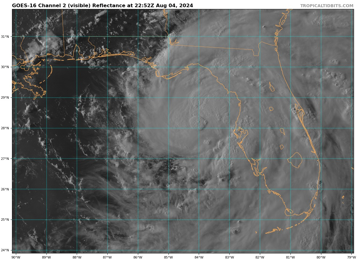
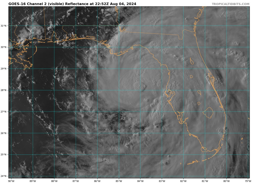
during the last 1/2 hour a big blob of convection developed just about right at 84W and just a pinch north of 28N...
-
Today's latest day 1 outlook mentions possibility of an upgrade to SLGT from MRGL in some areas of the east: ...Eastern States... A broad upper trough is present over the eastern 1/3 of the CONUS today, with slightly cooler mid-level temperatures and cyclonic flow aloft throughout the region. Morning visible satellite imagery shows strong heating across much of the Mid-Atlantic, Southeast, and TN Valley regions. This combined with a very moist surface air mass will yield steep low-level lapse rates and moderate CAPE later today, with several clusters of thunderstorms expected. Winds aloft are relatively weak, and mid-level lapse rates are not particularly steep. This suggests the bulk of this activity will be relatively disorganized. Nevertheless, given the coverage of afternoon thunderstorms and the pervasive hot/humid conditions, there is a widespread risk of gusty or occasionally damaging wind gusts this afternoon and early evening. Two areas of somewhat greater wind damage potential are from New York City region into northern VA, and from northern MS/AL into east TN. Both areas will be monitored and re-considered for upgrade to SLGT risk at 20z.
-
asking as a neophite... could the bay breeze collisions (?) be a factor in why things appear to be ramping up east of DC now?
-
yes that cell heading in the general direction of Warrenton is definitely on a strengthening trend and heading NE towards DC metro
- 1,696 replies
-
- 1
-

-
- severe
- thunderstorms
- (and 5 more)
-
looks like a bit of a westward wobble/jog in the last few frames, hard to tell if the bend back more W than WNW has started, Jamaica is hoping yes.
-
there's an okay cell that's been developing SSW of Front Royal heading ENE, nothing severe yet but it bears some watching
- 1,696 replies
-
- 1
-
-
- severe
- thunderstorms
- (and 5 more)
-
new severe thunderstorm watch for much of our western and central counties, guess they think the line to the west will hold together.
-
looks like a 5% TOR probability was added in the latest day 2 outlook from SPC for much of our area. Still SLIGHT risk though...
-
The Weekend Rule? Saturday 2/17 - The Icon Storm
batmanbrad replied to DDweatherman's topic in Mid Atlantic
hate to state the obvious but if we see Cantore anywhere near our area... -
measured (primitively) nearly 5" here in Gaithersburg (close to Laytonsville), still coming down lightly for now. Does look central MoCo/HoCo has been in the sweet spot so far.
-
Jan 18-19 Storm Threat: Bob Chill made me do it
batmanbrad replied to stormtracker's topic in Mid Atlantic
or even worse, SPC might include mentioning Georgetown in their convective outlook for Friday, including risk of hail the size of snowflakes? -
If you were able to post *current* pictures of the rain (and no snow) you've been experiencing the last several hours, we MIGHT believe you... but we're betting you can't/won't do that.
-
or worse (given they lost to the sorry Pistons earlier today and gave up their "usual" 130 or so points), the Wizards "defense"
-
heavy stuff just finished up here in Gaithersburg, we seem to have been in the (relative) sweet spot for QPF - between last night and today, about an inch measured at the airpark a couple of miles from me since midnight as of the 6PM obs there, added to the roughly 1/4 inch from yesterday.
-
yep, both lightningmaps and the MoCo airpark reporting station confirm the lightning earlier:
-
Hey, if Topeka can get more snow over this past weekend than they did all last winter (and close to their biggest November snow ever), we can certainly make a run at our total from last winter, right?
-
In the wintertime, assuming temps were cooperating, we'd be screaming PIVOT!!
-
with most areas close to DC seeing between 2 and 3 inches of rainfall, it would seem the models handled this overall pretty well. some yesterday were worried we would underperform on QPF, but it looks like instead of turning NE as the NHC and a few others predicted, the remnants of Ophelia pretty much stayed on a northerly track enabling the overnight rains to keep well within the I-95 corridor and points west. Despite the overall weakening trend, because the remnants were moving at a fairly slow pace, the rainfall amounts kept adding up nicely, especially for those in the worst drought areas. As of now Dulles looks like they got about 2.75" for a local airport jackpot.
-
coordinated with the the above-mentioned MPD by ThePhotoGuy... Flood Watch National Weather Service Baltimore MD/Washington DC 217 PM EDT Sat Sep 23 2023 DCZ001-MDZ011-013-014-016-504-506-VAZ053>057-527-240915- /O.NEW.KLWX.FA.A.0012.230924T0000Z-230924T1200Z/ /00000.0.ER.000000T0000Z.000000T0000Z.000000T0000Z.OO/ District of Columbia-Southern Baltimore-Prince Georges-Anne Arundel-Charles-Central and Southeast Montgomery-Central and Southeast Howard-Fairfax-Arlington/Falls Church/Alexandria- Stafford-Spotsylvania-King George-Central and Southeast Prince William/Manassas/Manassas Park- Including the cities of Washington, Baltimore, Bowie, Suitland-Silver Hill, Clinton, College Park, Greenbelt, Laurel, Camp Springs, Glen Burnie, Annapolis, Severn, South Gate, Severna Park, Arnold, Odenton, St. Charles, Waldorf, Bethesda, Rockville, Gaithersburg, Silver Spring, Columbia, Ellicott City, Reston, Herndon, Annandale, Centreville, Chantilly, McLean, Franconia, Arlington, Alexandria, Falls Church, Falmouth, Fredericksburg, Dahlgren, Dale City, Manassas, Woodbridge, Lake Ridge, and Montclair 217 PM EDT Sat Sep 23 2023 ...FLOOD WATCH IN EFFECT FROM 8 PM EDT THIS EVENING THROUGH SUNDAY MORNING... * WHAT...Flash flooding in urban areas caused by excessive rainfall is possible. * WHERE...District of Columbia. Portions of Maryland, including the following areas, Anne Arundel, Central and Southeast Howard, Central and Southeast Montgomery, Charles, Prince Georges and Southern Baltimore. Portions of Virginia, including the following areas, Arlington/Falls Church/Alexandria, Central and Southeast Prince William/Manassas/Manassas Park, Fairfax, King George, Spotsylvania and Stafford. * WHEN...From 8 PM EDT this evening through Sunday morning. * IMPACTS...Excessive runoff may result in flooding of rivers, creeks, streams, and other low-lying and flood-prone locations. Flooding may occur in poor drainage and urban areas. * ADDITIONAL DETAILS... - As the center of Tropical Storm Ophelia moves north along or near the Interstate 95 corridor, it will produce an area of enhanced rainfall. This is expected to result in 2 to 3 inches of rain, with high end amounts of 4 inches possible. This heavy rainfall will occur in a 1 to 2 hour period, and could result in flash flooding within the urban I-95 corridor. - Please visit www.weather.gov/safety/flood for flood safety and preparedness information PRECAUTIONARY/PREPAREDNESS ACTIONS... You should monitor later forecasts and be prepared to take action should Flash Flood Warnings be issued. && $$ KR
-
also looks like the 12Z GFS is (so far) west of 6Z, at least through 30.