

mahk_webstah
-
Posts
11,845 -
Joined
-
Last visited
Content Type
Profiles
Blogs
Forums
American Weather
Media Demo
Store
Gallery
Everything posted by mahk_webstah
-
Delwer's weather was not boring. Growing up had many big snowstorms, some brushes with hurricanes, a few tornadoes. A great place to grow up, although I was happy to leave.
-

December 2021 Obs/Disco...Dreaming of a White-Weenie Xmas
mahk_webstah replied to 40/70 Benchmark's topic in New England
qqanon? WWGRNAWGNAO? -
Why do we always have to suffer first??? Whhhhhyyyyyyyy
-
it hasn't been so bad up here....decently cold and some snow. But 50 miles to my south it is another story.
-
Well no Scott and no Will and no post for 2 hours. That says it all. I will say though that WPC does have all of NE down to Philly in the low end risk for frozen precip over .25 on Sunday but I think that is ana frontal and will go away on the next update.
-
Now we're talking! thats the torch you referred to earlier. If that ends up as the mean for that period, every single met I've read is wrong about the pattern over the last month, and where it was headed. And those are the educated ones! The weenies, well.... But I should add that how could anyone have foreseen this progression given what the analogs and models of all kinds have been putting out?
-
December 2021 Obs/Disco...Dreaming of a White-Weenie Xmas
mahk_webstah replied to 40/70 Benchmark's topic in New England
It is good to know if you are positive. It could affect when you decide to get a booster. -
Congrats Quebec City! For those of you who haven't been there, it is the best place for a winter vacation on this continent. Lots of snow, very old city with all sorts of monumnents to wars on this contintent over the last 400 years. Feels like Europe, with French spoken, but very friendly with English speakers. Amazing food and great charm and walking. Winter carnival at start of February last for 2 weeks and is well worth it. I think the USD is still strong against the CD. Go and your weenie needs will be met. Romantic as hell so bring the significant other and that last sentece will have multiple meanings.
-
so we just need to get the airmass refreshed behind the first wave? What is the timing on these if you don't mind?
-
would the first or 2nd wave help with the antecendent airmass? I was reading that that was the main problem for the weekend and early next week.
-
It usually doesn't happen, but stuff has been changing around alot these days even insider of 4-5 days. Maybe something will shift for the weekend/early next week.
-
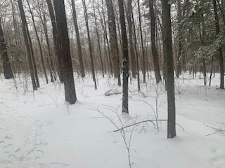
it is the 6.5" of really thick meaty snowpack up here that makes this tolerable. But if we don't get at least 6" of powder on top of this in the next week or 10 days, it will become a PITA. Up here we are on the edge but still optimistic. Deep winter look outside this morning on the walk.
-
I was ready to cancel on Xmas last year when my 28.5 inches melted off in 7 days.
-
3 or 4 degrees above normal is a torch in the 50s? I'm probably misinterpreting the map.
-
December 2021 Obs/Disco...Dreaming of a White-Weenie Xmas
mahk_webstah replied to 40/70 Benchmark's topic in New England
Winnuh winnuh chicken dinnuh -
We like the cold air source nearby especially when there is a SE ridge that pushes he storm track up our way. You don’t like where you sit in that gradient? It’s not a Miller A party but that is swfe and Miller b city
-
To me that looks good and would that not produce regular snowfall events across New England so perhaps not large ones unless we get something to dig in phase Miller b
-
But with blocking don’t we see a trend south or something towards redevelopment along the coast that helps out many or at least some?
-
Love that you did that. Brian and I live above 600 ft which makes a real difference to even the level at 93 along the river. He’s a few miles north of me though so he usually has slightly more snow but I think there’s a good 6 inches on the ground and it is definitely meaty. I’m hoping the week will be additive and then will get a big storm at some point
-
December 2021 Obs/Disco...Dreaming of a White-Weenie Xmas
mahk_webstah replied to 40/70 Benchmark's topic in New England
On my ride back home. Graupelly light snow here in SW CT at 36 degrees -
It’s generally good, although when we have a full PNA and a strong 50-50 we get screwed over. But you’re right in this situation we have a nice wintery landscape and maybe a great base if we don’t haw too much
-
December 2021 Obs/Disco...Dreaming of a White-Weenie Xmas
mahk_webstah replied to 40/70 Benchmark's topic in New England
And another 1-2 tonight? A bit more mixed Thursday? And then a question mark but probably at least somewhat frozen as the new year starts? That’s a solid pack that one 6-10 inch storm makes very nice -
I think 12/17/08 Give me about 5 inches, followed by about 12 inches on the 19th and another 14 inches on the 21st
-
From WPC overnight: A blocky and amplified ridge/upper high anchored over the northern Pacific should finally begin to break down and weaken next weekend. Before that though, renewed troughing (and chilly weather) will continue across the Western U.S., including a southern stream closed low near southern California Thursday-Friday. An initial northern stream shortwave will send one system across the Great Lakes/Northeast late this week, but by the weekend a stronger system (and northern Pacific ridge weakening) should finally allow for a pattern shift as amplified troughing shifts into the central U.S. and the East
-
Button pushet


