Eduardo
-
Posts
1,062 -
Joined
-
Last visited
Content Type
Profiles
Blogs
Forums
American Weather
Media Demo
Store
Gallery
Everything posted by Eduardo
-
I grew up in Lindenhurst and can confirm that, for some odd reason, we always seemed to perform well when it came to winds. No idea why though (guessing it's something geographical).
- 373 replies
-
- 1
-

-
- heavy rain
- wind event
- (and 2 more)
-
December 2020 General Discussions & Observations Thread
Eduardo replied to bluewave's topic in New York City Metro
I forgot how close last December was to delivering. It's comforting to see a lid on the SE ridge mid-month, although you'd think the Niña would snap it back into place at some point (OTOH, I am still waiting for last year's anticipated Niño atmospheric response...). But a ridge pressing inland from the NATL won't do us much better in the snow department since it'll just push the storm track inland too. Man, the glory years really spoiled us. I still don't think we'll see another shutout year like last year, but these past few years have been a cruel reality check: It's difficult to get solid snows down to the coast! -
November 2020 General Discussions & Observations Thread
Eduardo replied to Rtd208's topic in New York City Metro
Don't get me wrong, I'll take this all over the doom and gloom we thought awaited us last week. But the way I see it, as depicted, we would basically just be suppressing the torch for a time and could expect a snap-back at some point unless we can nudge some ATL or PAC ridging poleward a bit. I think the current look could work for us coasties yearning for snow later on in December, but I'm not sure it'll get the job done in its first week. If this is the best pattern we are going to get, I think we'd be better off if it was delayed by a few weeks. Hoping for some December 2017 fortune here! My gut tells me that we don't get completely shut out this winter. -
I see potential there for sure, but we'd need a bit more (i.e., centering that AK low pressure more toward the Aleutians) for us snow lovers to get what we want. As depicted, this is just a non-torchy pattern, not a cold one.
-
Chris, I take it the inverse does not hold true? For example, last November featured a respectable -AO. After that, IIRC, it bounced around in December for a bit and then shot through the roof.
-
November 2020 General Discussions & Observations Thread
Eduardo replied to Rtd208's topic in New York City Metro
Ah that seems so long ago now. Can always hope for some of the good fortune we had in December 2017, although it really does not look good right now. -
November 2020 General Discussions & Observations Thread
Eduardo replied to Rtd208's topic in New York City Metro
Would be great to slow down the firehose. It's definitely killed the last few winters at the coast. -
Easily gusting over 50mph in Brooklyn Heights.
-
Gusty here in Brooklyn Heights too. Easily in the 45–50mph range!
-
October 2020 General Discussions & Observations Thread
Eduardo replied to uofmiami's topic in New York City Metro
That's nuts! You have to wonder what it looks like once it's rolled forward (with shortening wavelengths, etc.). Thanks for finding these! I hate tossing '95 out there because it stirs up weenieism. I didn't realize that '95 had such low heights in the GOA and up top. NE PAC warm blob was sorta there though. -
October 2020 General Discussions & Observations Thread
Eduardo replied to uofmiami's topic in New York City Metro
For comparison, does anybody have a 500mb composite for October 1995? And maybe a global SST map? Just curious since that also was an active hurricane season + Niña autumn following a Niño, correct? -
October 2020 General Discussions & Observations Thread
Eduardo replied to uofmiami's topic in New York City Metro
::Scratches head:: This year's Sept./Oct. composite actually seems directly opposite to how Niña's typically behave in Canada and the NATL too. Do we know why? And are we going to wait around all winter for a Niña atmospheric "coupling" (hope I'm using the term correctly) like we did last year with the Niño? -
Yeah that was my first thought when I looked today. Can anyone explain the conservative LF intensity forecasts? I can see the low OHC in the northern gulf inducing some weakening before landfall, but what's stopping ζ from just taking off in the meantime?
-
Yeah I fully withdraw this statement. She's definitely looking better now that she's exited the YP.
-
She's all hollowed out. Reminds me a bit of Isidore in 2002.
-
Forgive me if I am mis-remembering, but didn't the January 2016 storm benefit from a "bootleg block" that originated up in the Scandi/Kara region? Like most, I am squinting hard to see some light at the end of the tunnel. The optimist in me feels good that we at least have the cold on our side of the pole. Were the PV locked up over Siberia right now, I think I'd have the towel in-hand...even up here. Great analysis in here, as always!
-
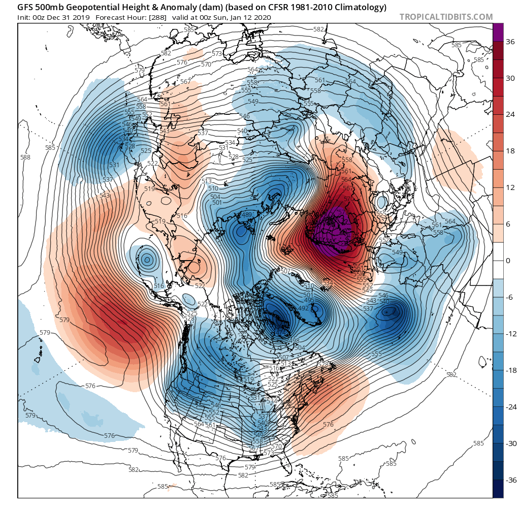
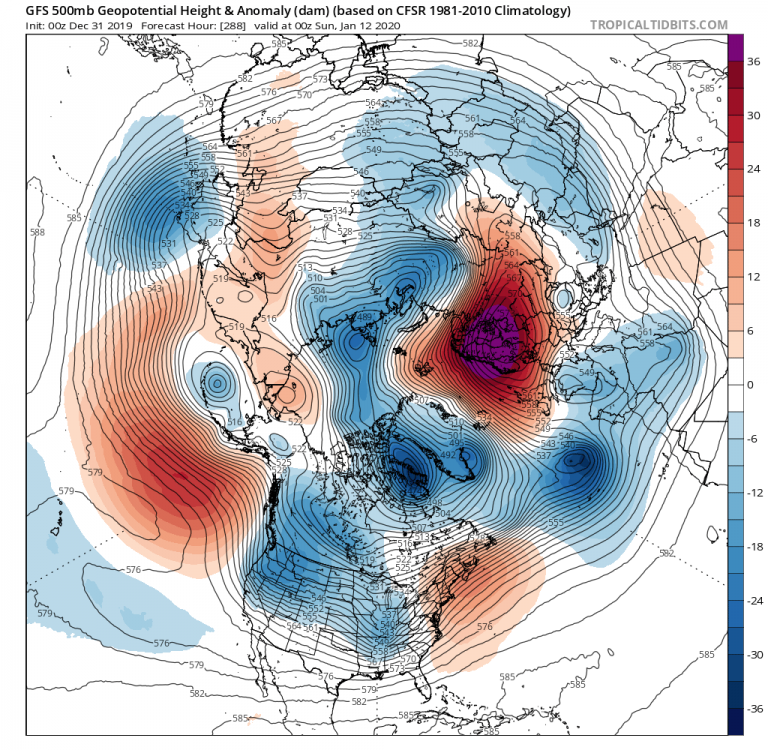
Hugging that Scandinavia ridge showing up on the 288hr op GFS. Pretty much all I’ve got given the doom and gloom on here today.
-
Vendor, Blog and TV Channel Forecasts Thread Part 2
Eduardo replied to Rjay's topic in New York City Metro
Ya that's a well-balanced take on the impact of social media, Don. Like any other tool, it can do quite a bit of good if one knows how to use it. A hammer is useful too, but not if you are swinging at nails with the claw. Similarly, with respect to meteorological information on social media, you will find yourself misled unless you have some background knowledge of the subjects with which it bombards you. Decent analogy can be drawn to the current state of our political affairs here, but that's one for a different forum -
How Important Is The -NAO For Top 10 Snowstorms?
Eduardo replied to bluewave's topic in New York City Metro
Much different synoptic setup than our typical blockbusters too. Wasn't PDII essentially just a humongous overrunning event? -
Vendor, Blog and TV Channel Forecasts Thread Part 2
Eduardo replied to Rjay's topic in New York City Metro
To be fair, I haven't read Mr. Cosgrove's forecast in detail. But given the immense lack of below-normal monthly departures in the last few years, to me, forecasting above normal temps with a confidence level less than or equal to 50% seems like a pretty 'safe' way to go, isn't it? -
Vendor, Blog and TV Channel Forecasts Thread Part 2
Eduardo replied to Rjay's topic in New York City Metro
LOL. Poor guy. As much as I vehemently disagree with his politics, can't understand his cold bias, and find his AGW stance flat-out wrong, I like him on a personal level and really do admire his enthusiasm for the weather. Not difficult to see that he's a good guy.