HKY_WX
-
Posts
3,246 -
Joined
-
Last visited
Content Type
Profiles
Blogs
Forums
American Weather
Media Demo
Store
Gallery
Everything posted by HKY_WX
-

February 19-20 Major Winter Storm Threat
HKY_WX replied to NorthHillsWx's topic in Southeastern States
If this keeps up, its going to be an central/eastern NC/VA Snowstorm special. Crazy trends the last 24 hours. Models are feeling the push of the blocking in Canada. Prepare for crazy NAM/HRRR runs the next couple nights. Get your whiskey ready.
-
February 19-20 Major Winter Storm Threat
HKY_WX replied to NorthHillsWx's topic in Southeastern States
I've just observed a bias this winter on the GFS specifically where it shears out STJ s/w's too quickly. It will likely be wrong with what it's currently showing. It doesn't make much sense in comparison to the pattern aloft. Eastern areas will see more QPF than western areas just by nature of being closer to the moisture source, but there will also be mixing issues further east. The only way I could see this busting for western NC is if the lead wave does indeed shear out/trend weaker and the main show is associated with the Atlantic low as the PJ re-energizes it. That said, I would need to see the EURO show this and it hasn't up to this point. -
February 19-20 Major Winter Storm Threat
HKY_WX replied to NorthHillsWx's topic in Southeastern States
How quickly we forget lol... This will trend both ways bf Weds. Just enjoy the fact that a juicy system is on the way and frozen precip is likely for many of us.
-
February 19-20 Major Winter Storm Threat
HKY_WX replied to NorthHillsWx's topic in Southeastern States
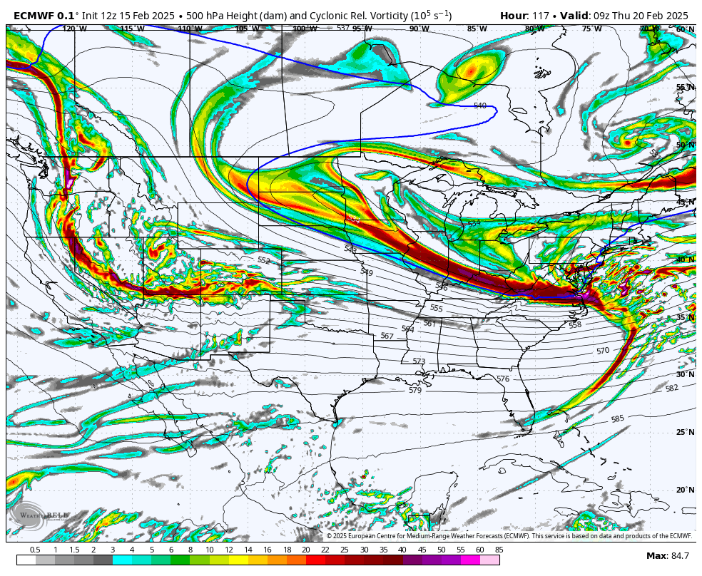
There will likely be an area of enhancement in NE NC/SE VA as the SLP strengthens. This is due to the PJ wave dropping in behind and re-energizing it. We've seen this scenario many times. THe GFS/EURO/GGM are all showing it now. Also the models have clued in on the strength of the blocking and are now shunting this OTS after hitting NC/VA which does make a lot of sense when you look at the broad pattern below: -
February 19-20 Major Winter Storm Threat
HKY_WX replied to NorthHillsWx's topic in Southeastern States
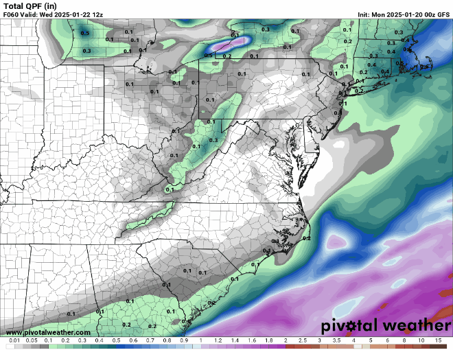
The worries regarding QPF will be short-lived when we get into the short-range. Especially given the consistency of the EURO with totals over 1". TheSTJ wave is amplified and doesn't shear out. It will likely be the opposite as the PJ wave drops in behind it and phases with it. How close to the coast is the million dollar question. Precip type is still the main issue in my mind for NC and where the SN/IP/ZR lines setup. That's still very much in question. As the models resolve the track of the low, the mid-levels (900mb-700mb) will be impacted and dictate that. -
February 19-20 Major Winter Storm Threat
HKY_WX replied to NorthHillsWx's topic in Southeastern States
18z Euro with a cool 2' in Richmond. I need that to trend 2 counties southwest lol. -
February 19-20 Major Winter Storm Threat
HKY_WX replied to NorthHillsWx's topic in Southeastern States
The Feb 96 system is prob my all time most memorable winter system in Hickory. Definitely the most damaging system i've seen outside of Hurricane Hugo and Helene in that area. -
February 19-20 Major Winter Storm Threat
HKY_WX replied to NorthHillsWx's topic in Southeastern States
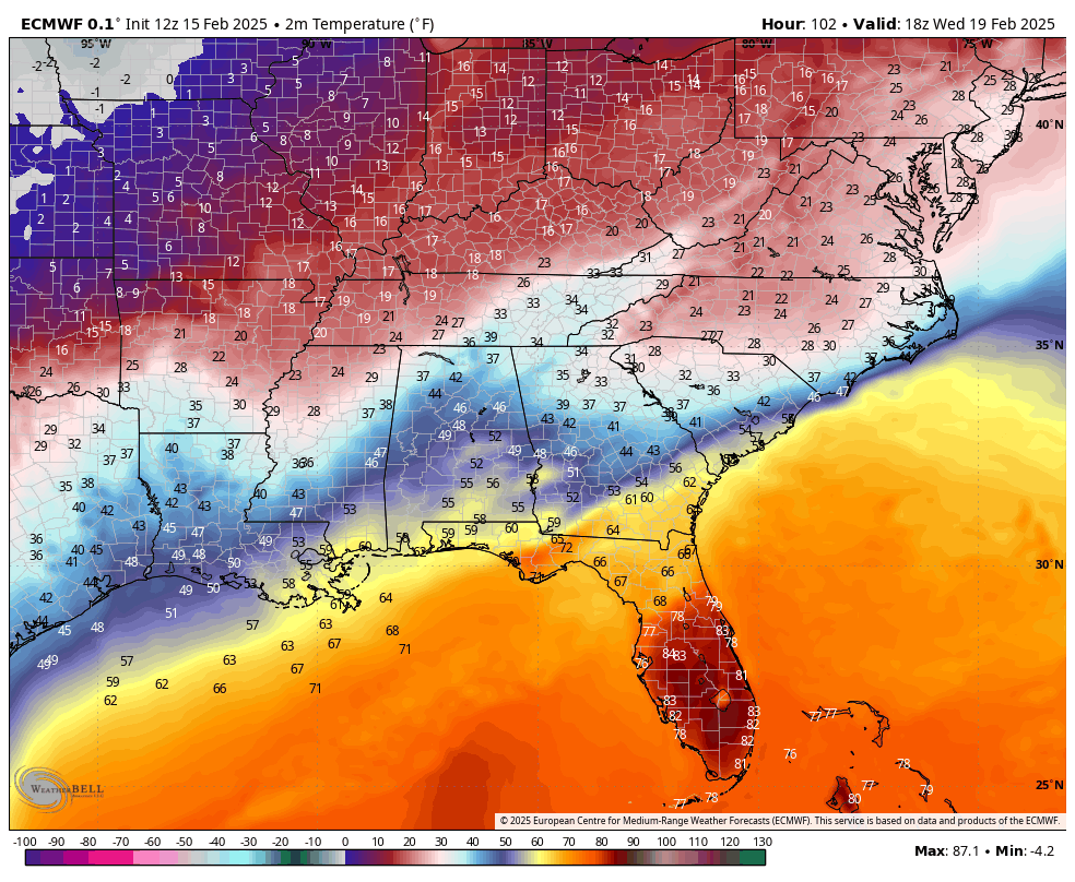
Taken verbatim that thermal boundary where the cold/warm meet is likely to be the SLP track. Roughly Valdosta GA to Wilmington NC. That really does favor snow in western NC. Areas in the N Foothills and Mtnd would likely get slammed in that situation as it would not changeover -
February 19-20 Major Winter Storm Threat
HKY_WX replied to NorthHillsWx's topic in Southeastern States
Interesting. Not directly related, but I've only ever seen 1 system in NC that ive experienced personally where we received significant sn/ip and also a significant accumulation of ZR. Dec 2002 in Hickory. Received roughly 6 inches of sn/ip followed by .3 or so zr. Extremely rare. Usually it's one or the other due to the nature of storm tracks and limited moisture supply. -
February 19-20 Major Winter Storm Threat
HKY_WX replied to NorthHillsWx's topic in Southeastern States
It's possible the models are starting to realize the strength of the cold dome at the sfc. This is pretty unreal low level cold air. Trying to remember the last time we've had a legit STJ impulse override a cold dome such as this. It's likely you have to go back to the early 2000's or 90's. Unless we see a trend NW with the SLP over the next few days I think Sleet/Snow is more of a threat than ZR. It's early, but with a Miller A that skirts the coastline, there will only be a thin ZR transition zone. It will mostly be Snow/Sleet given the cold dome and lack of a deep warm nose aloft. My concern is if we get a SLP trend where it gets a bit more NW towards the coastal plain, that could result in a legit changeover to ZR. Time will tell on that. I'm not sold on either at this point in time as it's about 4ish days out.
-
February 19-20 Major Winter Storm Threat
HKY_WX replied to NorthHillsWx's topic in Southeastern States
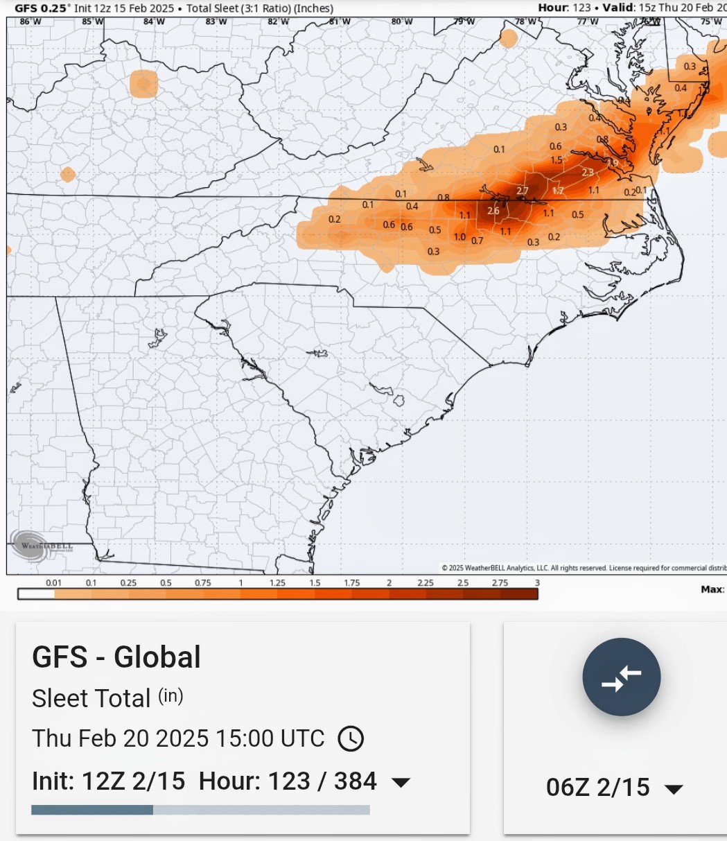
Euro here in southern Franklin County is prob 4-6 snow/sleet and then a 1/2" of ice... -
February 19-20 Major Winter Storm Threat
HKY_WX replied to NorthHillsWx's topic in Southeastern States
Now that we have some trials over the past 2 months, the canadian, icon, and nam have been pretty worthless past 48 hours. I would stick to paying attention to the gfs/euro combo. The HRR will also be usueful inside of 48. -
February 19-20 Major Winter Storm Threat
HKY_WX replied to NorthHillsWx's topic in Southeastern States
Just like that, GFS dropping 1 to 3" of sleet in Franklin county lol
-
February 19-20 Major Winter Storm Threat
HKY_WX replied to NorthHillsWx's topic in Southeastern States
A miller A to Miller A/B hybrid seems most likely. We're basically seeing a stj vort slide over the southern tier which spawns the original SLP. That is then captured by the polar jet wave which turns it up the coast into a Kocin type SECS event for the northeast. The parent HP location plus this eventuality to me favors some mix of snow/sleet/zr. Not a pure zr storm, except for those straddling the edge. -
Looks like the weekly planner on TWC in the late 90s https://x.com/chazzzwx/status/1890545541278294248?s=09
-
Euro is just a classic 80s/90s type nc north event. Big mixed bag in NC piedmont with the mid Atantic getting a big snow. A Parent HP over the dakotas has actually produced some of our more classic ice events. The parent HP that far west favors a long duration overruning setup. The trough axis tends to be a bit too far west for pure snow. I am concerned with the euro keying in one such large ice accretion this far out. Haven't seen that in many years for NC.
-
It's a bit far out to narrow that down. The parent high is a bit too far west to funnel a Wedge way south. But if the wave itself trends more suppressed then it will be a snowier solution (aka colder aloft). Too many variables at this point.
-
The ice threat is legit this go around. HP is str8 outta Compton (Siberia).
-
Ugh we got a ton of line trees here
-
Not saying it's wrong this time (a clock is right twice/day), but I wouldn't put any credence in that chitty icon model. It's horrible in general.
-
The patten is there. The details will irons themselves out in time
-
32.9 here west of Franklinton with rain. Ugh
-
To piggy back off of this from Jan. This is the first mid-range look I've seen since Jan that is enticing. Doesn't get much better. Weak PV lob over SE Canada. Virtually obliterated PV due to the large -AO and Greenland block. If it pans out around Feb 21st, i'll count that as a correct call from 23 days out ;).
-
1 week later you can see the results. This is a normal lag time between higher heights building in over the Poles and a pattern change over the CONUS. So we may have a window from roughly Feb 21 - Mid March where we could squeak out another event. We shall see.
-
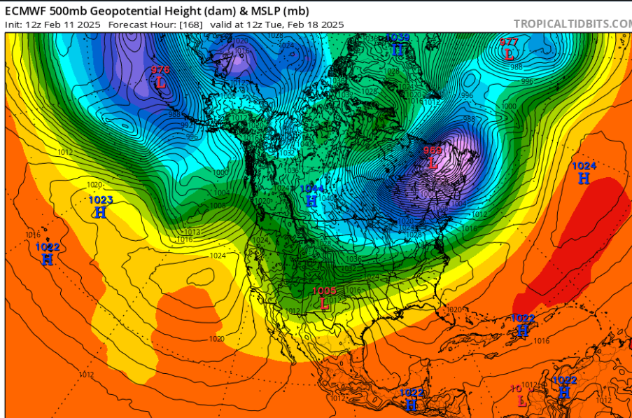
So next 2 weeks look very warm. AO/NAO are headed up and the PV is going to strengthen. This will allow the central/eastern CONUS to warm significantly vs January. That said, there are signals the 2nd half of February will be a transitionary period to perhaps a colder March in the east. See below for the 12z Euro extended 5h heights and the GEFS AO forecast.