

HKY_WX
-
Posts
3,246 -
Joined
-
Last visited
Content Type
Profiles
Blogs
Forums
American Weather
Media Demo
Store
Gallery
Everything posted by HKY_WX
-

-
ILM jackpot lol.
-
After getting a look at the 12z Euro AI, there's a bit of encouragement. Just need to get this wave out west to continue digging southwest. That will sharpen up the trough and get that overrunning moisture/firehose pointed more NNE instead of ENE. The margin on this one is very small and it wouldn't take much to be back in the game. The models giveth and the models taketh away.... But the models do sometimes giveth back...
-
More recent verification score for Day 5 SLP. 00z Euro Ens mean is king apparently. 00z Euro Ens mean: 8.47 8.5 00z Euro Control 8.3 12z GFS Ens Mean 8.2 12z GFS Control 8.0 00z GFS Ens Mean 7.9 00z Ukmet 7.9 00z GFS Control 7.5 00z Canadian 7.3 Show Replies
-
Some recent model performance. ACC (Model vs Reality/Reanalysis) at day 5 for 500mb. ECMWF = 1 CMC = 2 UKMET = 3 GFS = Distant 4th
-
Trend gif for the Sunday system in the Northeast. Something to keep in mind. It's just now within 4 or so days for that one. Specifically focus on the s/w over Colorado.
.thumb.gif.14e3f6d826cfb2d1263b6878e81a7cee.gif)
-
2 real players on the field. #1 is the Northern Branch. It will be favorable for most of next week (less so the further out you go into next week). With the PNA ridge being so strong , the tendency will be for the models to underestimate the how far south shortwaves (aka upper level disturbances/vorticity) associated with the polar jet dive south. From experience you usually see the models resolve this as you get inside of 5 days. If we do see a bit more digging, then it will likely pop a weak low in the GOM and (Depending on how much it trends) would favor a suppressed overruning system over the deep south and central/eastern NC. #2 is the cutoff STJ pacific system that is trending slower. This is likely not to come into play till later next week. How the northern jet interacts with that and how much cold air will be left is important to contemplate as to whether that could potentially be snow, ice, or rain. This could be a classic case of pacific moisture chasing a retreating cold air HP. I would favor in-situ CAD/Ice over western NC for that system. See the trends below for the last several runs on the GFS. Notice the Pacific system is trending slower and the Northern jet is starting to trend a bit better.
.gif.d25b84b74504d6c8effe94a0c7f2725a.gif)
-
First 2 wks of march are often some of our best chances. On next week, the euro and gfs are notoriously bad at resolving shortwaves in the southwest. Until they agree on when it kicks out, there will continue to be wild Swings.
-
Poof it's gone lol. Will take a few days to figure out if this is a legit threat or not.
-
To those worrying about rain. I think the margin for error on the models here will be more towards the east given the degree of cold. This airmass is Siberian in nature due to the +PNA/Cross Polar flow. It's been a while since we've seen a HP quite like this sitting over the Plaines. Not saying it can't/won't be ice, but I think an OTS solution is more likely than an Apps cutter, for example.
-
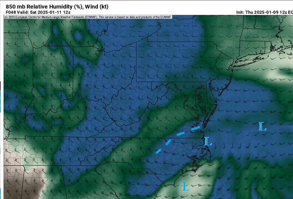
Can't see past this frame, but kinda surprised there's not some kind of weak surface reflection in the gulf at 168 given the jet amplification. The +PNA is pretty extreme, so it wouldn't take much to have a shortwave dig farther southwest than current advertised. It will be something to keep an eye on. https://www.tropicaltidbits.com/analysis/models/ec-fast/2025011312/ec-fast_z500_mslp_namer_8.png
-

1/10-11 super awesome winter SE OBS thread
HKY_WX replied to strongwxnc's topic in Southeastern States
Roxboro got 3 to 4. Snow capital of the "triangle". -
1/10-11 super awesome winter SE OBS thread
HKY_WX replied to strongwxnc's topic in Southeastern States
More zr in the triangle than I expected to be honest. Nam/gfs were too warm aloft for the lat couple days but did call the changeover. A blend of the euro and gfs would have worked pretty well. -
1/10-11 super awesome winter SE OBS thread
HKY_WX replied to strongwxnc's topic in Southeastern States
I have a 4 year old boy and he's loving it. The weather genes run strong in my family. My brother is the "great" RaleighWx. "great" was said with sibling sarcasm. -
1/10-11 super awesome winter SE OBS thread
HKY_WX replied to strongwxnc's topic in Southeastern States
1.5 here in Franklin county. Roads are a mess VID_20250110_205149.mp4 -
1/10-11 super awesome winter SE OBS thread
HKY_WX replied to strongwxnc's topic in Southeastern States
Hrr seems to have a good handle. Close to 1" here in Franklin county.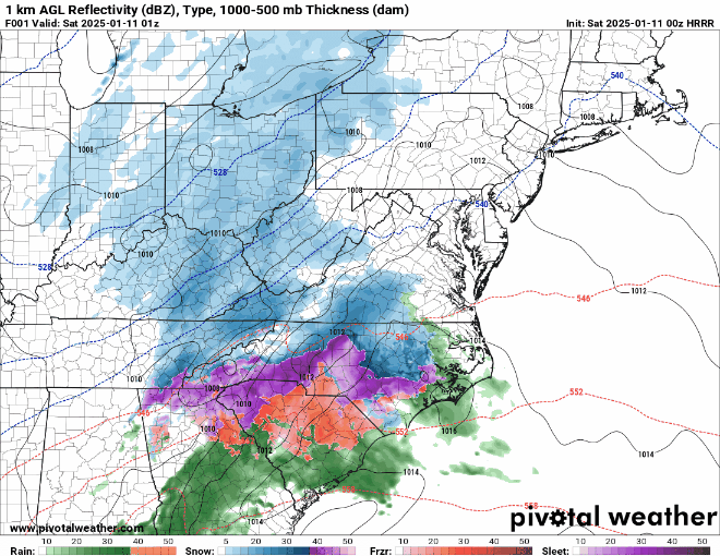
-
Meanwhile, at lake crabtree
-
He's either high or it's lake effect snow. I'm leaning towards high.
-
Kuchera method is probably more accurate representation. But yea, the NAM related suite (NAM/HRRR/etc) have slowly moved that band from VA down into northern NC run by run. It's much more similar to the euro/RGEM from the last few days which has always made more sense. i85 special.
-
Where in rdu are u? I'm up b/n Franklinton and Creedmoor now Feel better about my spot vs the old days in the Crabtree area.
-
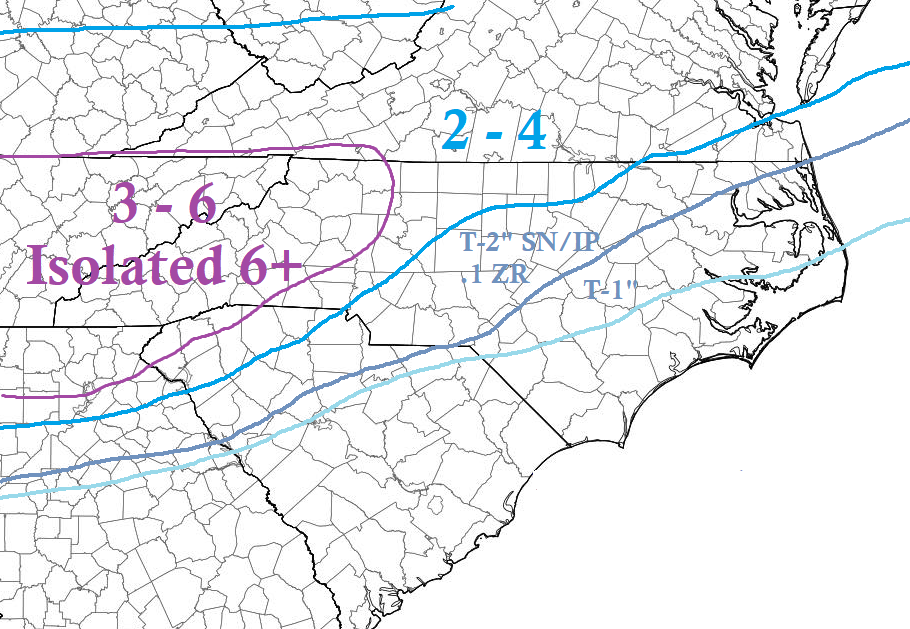
I put this out a few days ago. Will stick with it. I would prob add some sleet and zr to the transition zones though. And extend the 3 to 6 along the nc va border to the va coast.
-
I'm going to participate in weeniecast phase 1. The HRRR has heavy sleet/mixed precip all the way down to Montgomery AL - Columbus GA late tonight.
-
Something like this
-
Euro has a nice band over NE NC/SE VA as the SLP starts to deepen off of NC. Something to watch, as it could lead to some higher totals in that area. You can see a reflection aloft at 850mb developing offshore NC on the Euro. This will likely enhance totals in that band due to some moisture advection/lift/dendrite growth. Not sure it would qualify to be declared a "deformation zone" but an area of enhancement.
-
I'm still a bit skeptical at the ZR numbers given the SLP not being a Miller B but more of a Miller A.


.gif.1f97fa636f59e97a8dd84c5511b7cc8c.gif)


