HKY_WX
-
Posts
3,246 -
Joined
-
Last visited
Content Type
Profiles
Blogs
Forums
American Weather
Media Demo
Store
Gallery
Everything posted by HKY_WX
-
Just from past experience, these runs have the look of a model attempting to resolve a phase or cut off low. I've seen this too many times to ignore. I wouldn't be surprised to see them slowly trend more amped on the backend as the SLP moves towards the Atlantic. It's almost impossible for the models to sort out the various Canadian shortwaves this far out. Given the Atlantic pattern, it's pretty likely this will bomb out, but as far as where remains to be seen. Could be way out into the Atlantic, or it could be off of NC. Doesn't necessarily mean we will benefit from it.
-
As you can see below from this view. The Low over the Atlantic will force everything from Canada underneath it. Which increases the odds of a phase and large cutoff system. Could be great for us or could be not so great if we change to rain.
-
I wouldn't be surprised to see this trend towards a more phased/cut off look given the strong cut off low over the northeast. This really slows down the flow and promotes phasing/cutoffs upstream. We haven't had a setup like this over the Atlantic in many years. The only issue is we don't have a major/classic CAD setup so we will run the risk of a change to rain outside of western NC. That said, the degree of cold air ahead of this system is pretty strong. Will be a fun one to track this week for sure.
-
This is a solid setup for snow and ice in NC. Obviously not a major storm but solid.

-
Euro ensemble mean is about .25 average across NC for Fri/Sat. That is probably the low end in my opinion. This looks like a classic in-situ wedge storm where we start off as a burst of snow and then change to a mixed bag. It could obviously trend a bit stronger or weaker, but for now it looks likely for at least some decent/measurable wintery weather. Beggars cant be choosers after the last few years.
-
32* Here in franklinton. Still got freezing rain for the moment. Drove my son to school and there's nothing once you get down to the wake county line.
-
Nice pics
-
Generally this referrs to the NC Mountain valleys, foothills, and NW/Northern Piedmont and NC/VA border areas along the interior.
-
Definitely a noticable trend south amongst the models with the HP system. i think the Cold air is pretty strong on this one. I like the CAD areas getting some ice on this one.
-
Most significant change overnight was the models with the quick bend east now. I'm thinking more along the lines of Siesta Key area now. This will speed up landfall as well. Probably later this evening. I'll stick to roughly 135mph. Pressure will probably head up toward 935 to 940mb. That said, I believe the weakening is being overplayed a bit.
-
It's hard to comprehend these pressure numbers were throwing around only 30hrs from landfall
-
Yeah, the calculation factors in the depth of the warmer waters. I'm assuming the shelf waters are just excluded.
-
Those are great points. It is to a point where even if all systems are go, it may already be maxed out from an atmospheric perspective.
-
I'll think we'll be surprised just how strong it is. To me it has a more impressive appearance than yesterday.
-
The overall structure looks solid right now. Not seeing any issues of shear or dry air like last night. I think it's all systems go until about 10am tomorrow and then it will level out and slowly weaken. That said the damage may already be done. The amount of weakening is probably being overplayed too IMO.
-
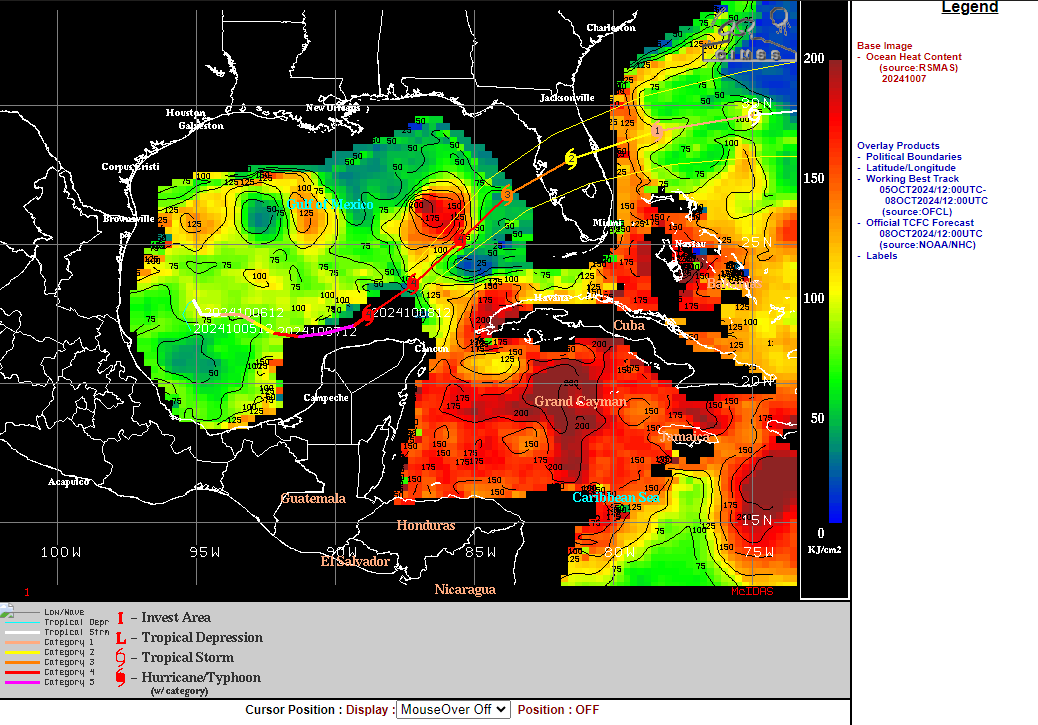
Here's a good map of the OHC with the track overlayed.

-
Definitely listen to the local officials, not some weenies on a message board.
-
It's definitely picking up a bit of pace and heading NE. It's feeling the tug of the trough. This is also apparent in the prominent banding to the NE. As it clears the Yucatan completely and enters the extremely deep/warm waters of the loop current, this where it could reach that 2nd max potential. This is where Katrina built up its immense surge. If you're in the cone and near the coastline, get da hell out. The west coast of FL may have never seen a storm like this one.
-
Euro has peak intensity around 10am tomorrow. Before leveling off and then slowly weakening tomorrow afternoon/evening on approach. So we may have another interesting night lol.
-
I think i'll go with landfall near Anna Marie FL. Pressure 935mb. Wind Speed 130mph. Peak surge from Anna Marie to Siesta Key up to 20ft. Perhaps isolated areas with more. Enough water is going to be pushed into Tampa Bay that areas of Pinellas county will still have major problems. Perhaps more so on the Bay side.
-
That's a real chitty radar to be basing anything on.
-
I think it may have ingested some dry air off the yucatan landmass as the eyewall got extremely close yesterday evening. As it moves NE and gets into the loop current it will likely have the opportunity to restrengthen today. Kinda scary the HWRF, HMON, and HAFS all zeroed in on TB at 00z tonight...
-
The eye is definitely going through some cycling right now just based off of the satellite.
-
There is a bit of dry air on the far eastern semi-circle over the Yucatan. I'm thinking we will level off tonight and the pressures might tick up. Sometimes this kinda thing will generate an ERC. My guess is we make another run tomorrow as it traverses the loop current.
-
It's de facto and baked into the cake that Milton will weaken from its current state. These #'s are only possible in perfect environmental circumstances (low shear, high oceanic heat content, etc). The Southern GOM, Northern Caribbean, and loop current are areas where there have many historic bombogenesis events. The Euro AI and GFS both have a solid handle on Helene. Both have a good environment for Milton up to Landfall. I don't see it heading towards a hostile environment per se. It's just a more traditional one. The only saving grace I can see at this point is the rather small size, but these storms tend to build size over time as they navigate the open waters. This will be a bad/catastrophic one unfortunately. Obviously a bit too early to pin point if it will hit Tampa Bay directly or just to the north/south of the city. Stay tuned.