HKY_WX
-
Posts
3,246 -
Joined
-
Last visited
Content Type
Profiles
Blogs
Forums
American Weather
Media Demo
Store
Gallery
Everything posted by HKY_WX
-

Potential 1/28-1/30 2022 winter storm
HKY_WX replied to Prismshine Productions's topic in Southeastern States
Being from Hickory I always wondered what went on at meat camp. Then I drove through one time and realized absolutely nothing goes on at meat camp. -
Potential 1/28-1/30 2022 winter storm
HKY_WX replied to Prismshine Productions's topic in Southeastern States
One thing to watch this evening is as the upper low begins to form and take shape off of the NC coastline is a nice deformation axis likely 100 -150nm to the west of the 850mb low. This is where there could be some banding/enhancement. If this were to occur a bit earlier or more dramatically than forecasted (aka phasing), obviously that would impact totals in a positive way (most likely area that would benefit is eastern NC and SE VA)... Something to keep in mind. Otherwise I will go with the below: HKY:T-1 inches CLT: 1-2 inches GSO: 1-3 inches RDU: 1-2 inches ORF: 2-4 inches -
Potential 1/28-1/30 2022 winter storm
HKY_WX replied to Prismshine Productions's topic in Southeastern States
I think what we're seeing is the mods having difficulty handling the last minute phase possibility. The NAM actually trended better this run for that. IMO there will likely be a band setting up over central NC tomorrow night/Sat Morn that will pivot east. The strength of the band will be totally dependent on how much phasing we see at the last minute. More phasing and this band could drop 6+. Less phasing and it's just some snow squalls. -
Potential 1/28-1/30 2022 winter storm
HKY_WX replied to Prismshine Productions's topic in Southeastern States
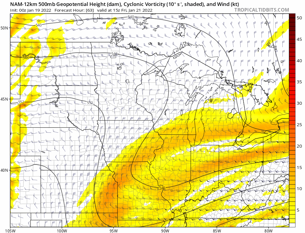
He's just comparing the Water Vapor Satellite with the NAM's 500mb chart. You can sometimes spot where the models are off. I've often noticed in the winter (specifically +PNA patterns) they tend to be bad at positioning northern stream impulses coming out of the northern territories of Canada. If anyone remembers the Christmas 2010 storm, they totally blew the northern stream shortwave which is why that trended towards a major storm literally the night before. Not saying that's the case here as the models have made huge strides since then. He also has a dog in the fight so take satellite hallucinations with a grain of salt. -
Potential 1/28-1/30 2022 winter storm
HKY_WX replied to Prismshine Productions's topic in Southeastern States
The trend is beneficial to more phasing ultimately. -
Potential 1/28-1/30 2022 winter storm
HKY_WX replied to Prismshine Productions's topic in Southeastern States
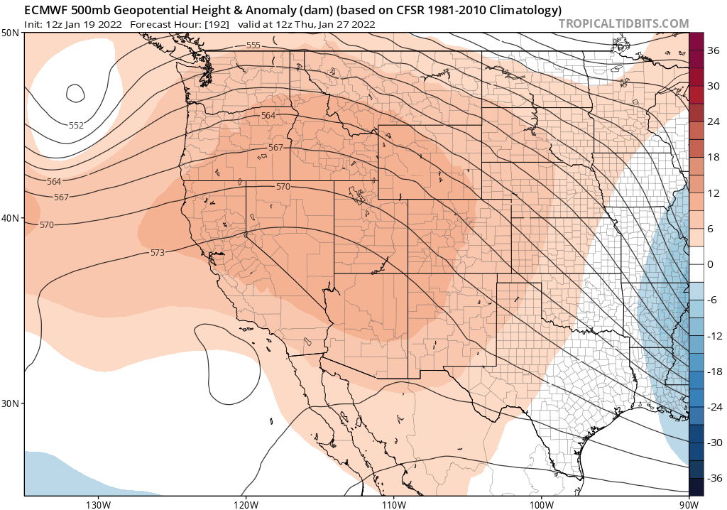
Euro continues to trend the ridge out west stronger. This is what's allowing the PJ to dig/dive a bit further southwest and capture some of the southern energy. Interesting trend to watch.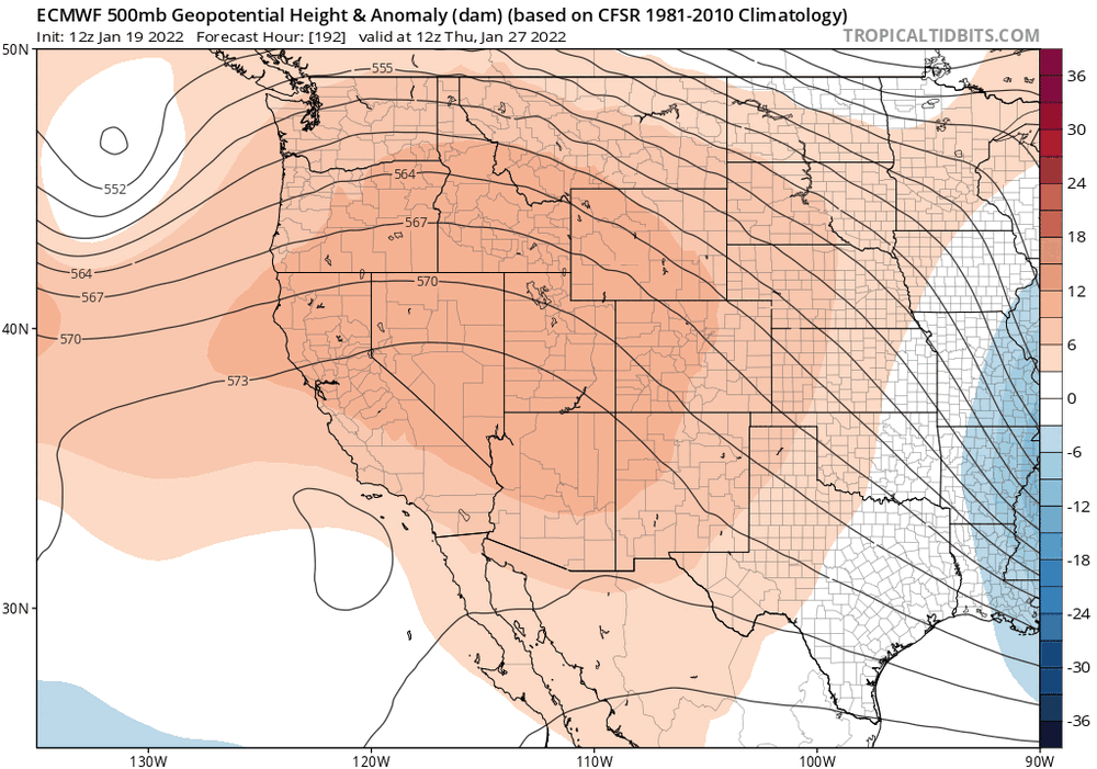
-
Potential 1/28-1/30 2022 winter storm
HKY_WX replied to Prismshine Productions's topic in Southeastern States
To reiterate this. The NAM didnt leave any energy behind in the southwest resulting in a full lattitude negatively titled trough aka phase. We need that energy to be captured by the northern stream for this to work out. -
Potential 1/28-1/30 2022 winter storm
HKY_WX replied to Prismshine Productions's topic in Southeastern States
Yeah the NAM is pretty ideal for eastern NC. I could throw out some analogs to those 500mb maps, but theres no point in jizzing yourself unless we see some additional model support. -
Potential 1/28-1/30 2022 winter storm
HKY_WX replied to Prismshine Productions's topic in Southeastern States
Def would like to see the other mods start following suite, however if you think back to the coastal bomb a few weeks ago... The NAM had the amped solution first. -
Potential 1/28-1/30 2022 winter storm
HKY_WX replied to Prismshine Productions's topic in Southeastern States
If you could play the NAM forward the SLP would probably track towards or just off Hatteras which is a great track for central/eastern NC. Eastern VA/NE NC would likely get smashed. Still, need to see some additional model support or continued trends towards this. The euro actually trended more favorably aloft at 12z, however it didn't really manifest itself at the surface. -
Potential 1/28-1/30 2022 winter storm
HKY_WX replied to Prismshine Productions's topic in Southeastern States
Yea the clock is ticking. We need this euro run to be favorable. -
Potential 1/28-1/30 2022 winter storm
HKY_WX replied to Prismshine Productions's topic in Southeastern States
The trough is a bit too positively tilted to throw enough moisture back (at least in the southern Mid-Atlantic). The best bet on this one is for the northern stream to continue to trend a bit stronger/further west. That enables it to capture the southern energy (there a few different ways this could happen though). This would draw in a little more gulf moisture and also result in a quicker phase which would tilt the trough more negative and allow the SLP to track closer to the coast. The chance is there, but again the odds aren't great unless we see some solid trends soon. -
Potential 1/28-1/30 2022 winter storm
HKY_WX replied to Prismshine Productions's topic in Southeastern States
I would still rather have the euro in my corner as well. In general it's still the best in the medium range. -
Potential 1/28-1/30 2022 winter storm
HKY_WX replied to Prismshine Productions's topic in Southeastern States
I'm not forecasting anything as of now, but the models never look good until they do. If all you do is look at the ensemble statistical output you're just a modelologist. Nothing more. -
Potential 1/28-1/30 2022 winter storm
HKY_WX replied to Prismshine Productions's topic in Southeastern States
Boom -
Potential 1/28-1/30 2022 winter storm
HKY_WX replied to Prismshine Productions's topic in Southeastern States
Certainly possible but the ridge axis out west is in a good spot for a Miller A coastal system. -
Potential 1/28-1/30 2022 winter storm
HKY_WX replied to Prismshine Productions's topic in Southeastern States
This is a favorable trend on the GFS ensemble mean for additional/earlier phasing. Who knows if it will continue.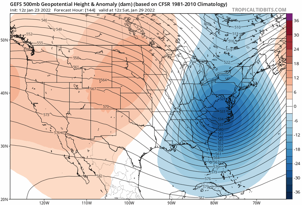
-
Potential 1/28-1/30 2022 winter storm
HKY_WX replied to Prismshine Productions's topic in Southeastern States
This setup is not overly different from this past weekend with the large +PNA ridge out west and incoming PJ s/w from Canada diving into the plains. The euro shears this shortwave out enough to delay the phase which ultimately results in some backlash snow showers over eastern NC as it wraps up and pounds the Northeast. I will say this, there isn't much margin on the Euro/GFS between flurries and 12+ inches. This shortwave has some serious potential if it were to cutoff/phase earlier (of course theoretically they all do I guess). Still a solid 4 days out and time to trend (in either direction). Lastly I will say this appears to be the end of the pattern that has provided us a pretty solid January of storms. These great patterns have the tendency to end in a bang (Although that doesn't necessarily mean your backyard will get hammered). -
Light ip/sn mix in wake forest.
-
January 20-22 “bring the mojo” winter storm threat
HKY_WX replied to lilj4425's topic in Southeastern States
Def favorable trends in most models over the last cycle or 2. -
January 20-22 “bring the mojo” winter storm threat
HKY_WX replied to lilj4425's topic in Southeastern States
Ill go with the following HKY: T-1" CLT: T-2" GSO: 1-3" RDU: 3-5" ORF: 6-10" -
January 20-22 “bring the mojo” winter storm threat
HKY_WX replied to lilj4425's topic in Southeastern States
The key is to get this s/w to trend/dig back southwest. Notice tonight's 0z stopped the trend eastward. We're just running out of time.
-
January 20-22 “bring the mojo” winter storm threat
HKY_WX replied to lilj4425's topic in Southeastern States
NAM finally bucked the trend this run aloft. I think the east shifts may be over. We shall see. -
January 20-22 “bring the mojo” winter storm threat
HKY_WX replied to lilj4425's topic in Southeastern States
No worries guys... its getting late... But there always the ICON. AKA the ugly girl at the bar. -
January 20-22 “bring the mojo” winter storm threat
HKY_WX replied to lilj4425's topic in Southeastern States
That looks like the same trend as the Panthers win total year by year.