HKY_WX
-
Posts
3,246 -
Joined
-
Last visited
Content Type
Profiles
Blogs
Forums
American Weather
Media Demo
Store
Gallery
Everything posted by HKY_WX
-
Good points. The main reason I think is b/c the pattern is trending more progressive over the eastern CONUS/Canada. This has eliminated the Apps runner scenario which would have overwhelmed the wedge with warm air aloft/down. Now we're trending towards a True Miller A/B hybrid. This generally brings more sleet into play over VA/northern NC from my experience.
-
Interesting to look at this trend gif and see the clearing over central/southern VA. Over time, it looks the NAM is trending towards a deeper cold dome (sleet) for those areas. This would generally shift the ZR line south as well. Time will tell.

-
Same trend on the euro...
-
NAM has a solid trend towards a stronger wedge (especially note the escarpment/foothills of NC/SC/NE GA). However, not too sure I'd pay much attention to the NAM precip fields this far out.
-
There's still time on the southern periphery for some trends (in either direction). Not talking about whole-scale changes. The setup is the setup. This has been apparent for the past week. Once this HP get's far enough east, we will get in on the Ice eventually ("we" being the southern VA/western/central NC).
-
Yea if you just look at the overall pattern at 48 - 72 hours on the euro (500mb/SLP), it's pretty classic looking. From an IMBY perspective, I'm not sure how RDU will fair at this point. We would need the cooler trends to continue to get anything more than advisory criteria ice. That said, the more classic CAD areas look good for WSW and Icestorm Warning criteria ice. Ground zero looks like MTV/DAN area.
-
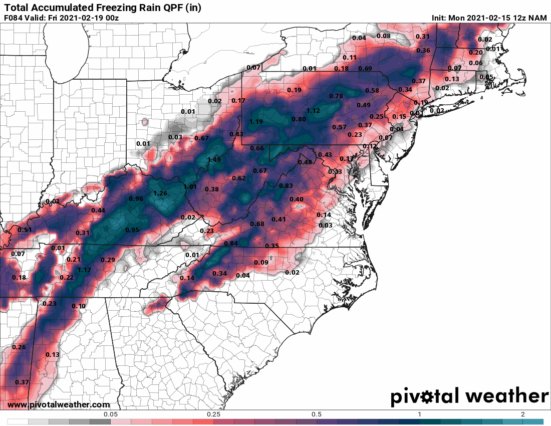
Whoever's on the southern extent of the wedge (Right now looks like northern NC/Southern VA), most likely will get a crippling icestorm (.75+ ZR accrual). I would need to pull the bufkit soundings, but that same area from Roxboro to MTV to GSO looks bad. I'd be buying batteries/etc right now if I were you.
-
Looks like .3 to .5 is likely in that triangle from MTV to GSO to Roxboro. Will be lights out for a lot of peeps tonight. You could see this coming. Being an ice storm nerd, it's ashame we couldnt a more widespread event for NC. I know many will disagree lol
-
Something to remember, this CAD has a direct connection to the parent HP over Canada. Once we start getting the northeasterly wind feed setup later this week, I have a hard time seeing the wedge breaking until the HP moves out of position offshore, which wont' happen until next week. It's honestly going to only get stronger as time goes on and the HP buildings into the Dakotas and eventually slides east. So we could be looking at several days of freezing rain/sleet coinciding with the STJ impulses that are coming through. The models will likely trend towards this solution over time.
-
If this comes to pass, I look forward to watching the northern transplants in Raleigh attempt to drive to work on ZR at 20 degrees... "'Cause they are used to that up north...." No offense to northern transplants in Raleigh who view this board (you're obviously excluded)
-
-
I think the bolded is key with it becoming more evident we're going to have the HP in a good spot from Thursday - Tuesday... The main driver will be timing the STJ impulses that are going to come through.
-
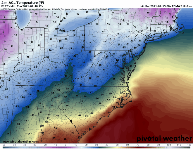
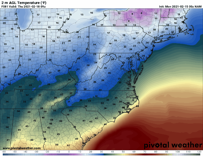
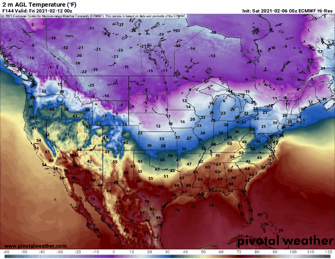
Checkout the Euro 2m surface trend below. This includes the last several runs of 0z/12z.... Notice the trend of the cold temps at the sfc bleeding towards the south over the central/eastern US. This is a classic old school model bias. It's due to the model physics missing the true density of the cold air at the surface in the long range. This likely isn't the end of the trend either...
-
PD2 storm back in 03 had a backdoor CAD front that was unreal. Started as Rain in the 40's and eventually turned into ZR and IP in the 20's. It had a similar CAD setup with the Parent Arctic HP.
-
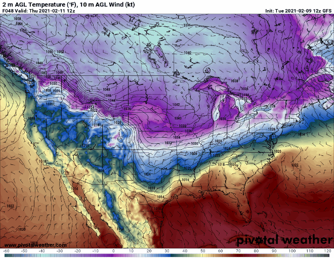
It's been many years since we've had a true expansive Arctic HP over the Plains for days like the models are portraying. Could be a fun 10 days of tracking.
-
I'd expect to see a lot of waffling over the next few days, however this is a much more traditional look for a winter storm in favored areas in the Southeast (GA/SC/NC). Especially ice. I think in the end that will win out. The most important feature on this one will be how the 50/50 low trends (see below over the N Atlantic). If this trends weaker, this will be an Apps cutter. We need this to be stout and lock in the HP over the NE. The odds are in our favor as the atlantic has been pretty good for the past month and conducive for lower heights in this area due to the -AO/NAO. To be continued....
-
Day 7 is more of a classic NC ice/snow storm. Doesn't get much better than that look. Need to reel this one in.
-
GFS and EC ensembles are pretty much on top of each other through day 6... For those looking for some positive nuggets. The OP Euro's evolution out west appears pretty unlikely. Additionally it's pretty rare to see a large cold dome like this dislodge and head SE towards the CONUS. Sometimes the mods have difficulty in these situations due to the density of the airmass. Normally they don't just put on the brakes and stop north of the Dakotas.
-
GFS ensemble mean is nice for potential next weekend. Wish this wasn't so far out
-
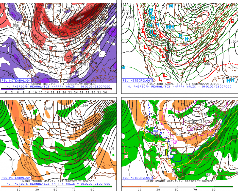
Here's your analog, gentleman, if it comes to fruition. Again, a very rare setup and capable of producing 30 to 40 year type events for the south. http://www.meteo.psu.edu/fxg1/NARR/1996/us0202.php#picture
-
The GFS/Euro are actually in pretty good agreement when you compare them through day 8 or 9. There's not a huge difference from the standpoint of the Northern Hemispheric pattern aloft. The main issue is the anomalous nature of what they're showing and how it's not likely statistically. That's the main thing we have going against us. How often do 1050mb Highs enter the Dakotas on the backside of a sub 490dm PV lobe in the great lakes? However, the AO is in serious neg' territory, so that lends credit to this.
-
The true Polar Vortex is completely shattered on the day 10 look from the Euro. It's broken off into several Lobes. Classic -AO look below. This bodes well for the rest of February IMO.
-
Checkout GSO obs from that storm. It mirrors Hickory pretty well. Once the precip changed over to SN and it started accumulating on the Ice, the trees just went down like flies. Then bitter cold for the next few days. https://climate.ncsu.edu/climate/winter/station_data?e=163&t=h&s=KGSO
-
Yeah its #1 on my storm list. That's why some healthy skepticism is need for now. If we're still seeing this solution next week, it will be time to honk.
-
Euro paints a pattern similar to late Jan/Feb of 96. Full scale arctic blast with overrunning on the SE side for the entire SE.... Really hard to get this to happen, so we need to reel this in to at least inside 7 days bf getting excited. This has more of mid 1990s look to it.