

HKY_WX
-
Posts
3,246 -
Joined
-
Last visited
Content Type
Profiles
Blogs
Forums
American Weather
Media Demo
Store
Gallery
Everything posted by HKY_WX
-
Euro phased in the polar jet wave on the backside. This is actually prob better for those in eastern nc, as it results in back end deformation banding. Overall still a great thumping. The slp is more aligned with what youd expect from this
-
This has to be the largest amplitude STJ wave I've seen since Dec 2002 and Feb 2004 events. The 2 to 3 inch QPF totals are very likely with this one.
-
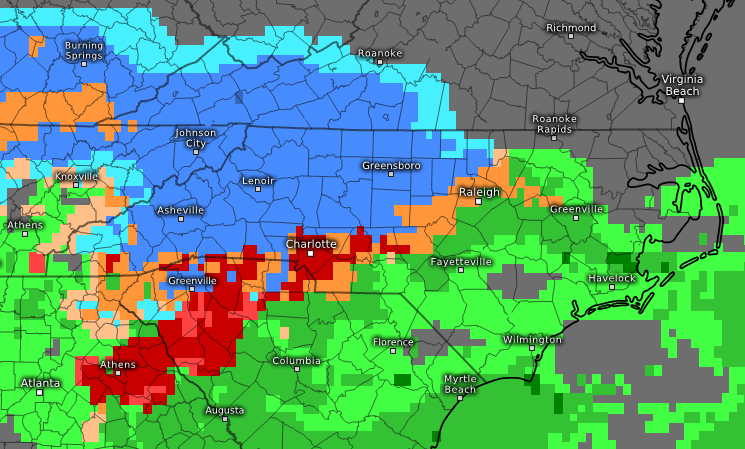
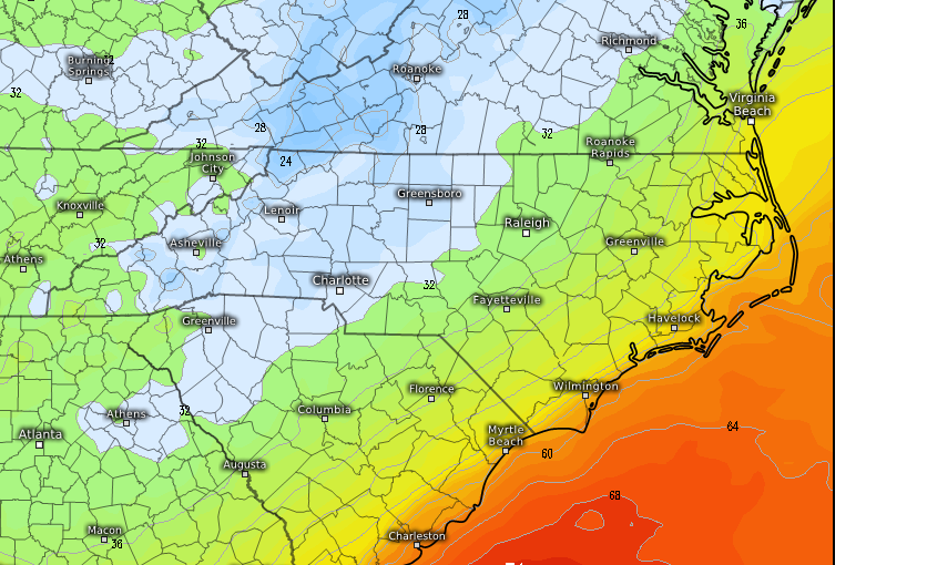
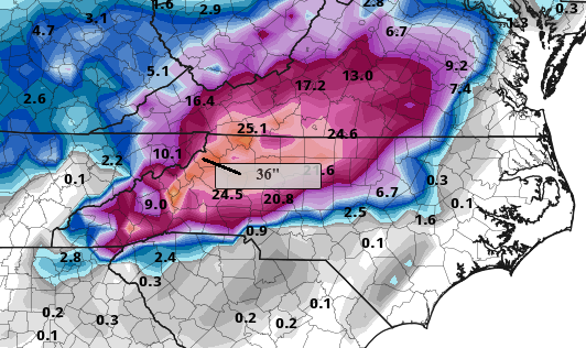
The euro has caved with regards to Ice. It now has a strong wedge/ZR cone down into Athens GA. I look for this to expand over the next several days. The cold air source isn't overwhelming given we are so early in the year, however the position of the HP is pretty much ideal. So that in and of itself will generate enough ENE/NE winds to funnel dry/cold air down to cause ZR at 30-32*. Image effect 9PM Sunday... Also on a few frames I noticed the IP line inching towards hickory/Greensboro. Once again, that will impact totals in those areas like always. It will turn a 24 inch storm into a 10inch storm.... IP has been the ruin of many potential historical totals in the southern/Central Foothills/Triad. NW of that line and above 2500 ft..... The sky is the limit on this one...
-
Nevermind lol... My location from Friday to Monday!
-
Anyone have the banner elk GFS totals? Lol
-
I'll be in Banner Elk this wknd lol... Will be interesting dor sure... As grit noted, this stj low has the hallmarks of a memorable el Nino snow/ice maker ala dec02 and feb04.
-
The issue is surface lows don't run in a straight line. They jump contingent on upper level forcing and dynamics. My guess is we see a weak SFC low reflection over southern Ms valley, then near mid ga, then eventually offshore. Not a true Miller a or b. This usually means snow in the nw mtns, snow to ice in the foothills and northern nc, snow to ice to rain elsewhere.
-
I would never hang my hat on anything the GFS depicts, however the euro at this range is generally pretty good with overall pattern recognition.
-
If the modelling is close to being accurate on the HP, I'm not overly worried about surface temps. This rivals some of the better HP configurations I've seen in a while. A lot about this setup reminds me of Dec 2002/2003. Mostly driven by good timing of a HP system and excellent split-flow +PNA setup. I think this will definitely have a solid ICE trainsition zone b/n the snow and rain. The outlying question is how much interaction we get w/ the northern stream on the backside, as that will likely start edging the SLP closer to the coastline and push the ICE futher NW. This setup is likely to be a Miller A/B hybrid w/ a SLP in the lower deep south and then potentially riding the coastline. I really like areas of NW NC. Foothills/mountains into southern Virginia when it comes to pure snow. I am soooo tempted to just go to Banner elk for my AirBNB w/ the family and hope we get trapped lol.
-
I was supposed to go to banner elk for an airbnb this coming wknd lol.
-
Clown maps look nice, but with this SLP track, there will be a lot of mixing. HP setup looks good. Should be a very moist system, given the amplitude of this STJ wave. Def a Nino esk split flow setup in the Pacific ala 02 03 and 09 10. Sent from my SM-G955U using Tapatalk
-
Concerned about tornado spin ups in the triangle this afternoon/evening. We'll be in the right quad later today and after some daytime heating/instability, will be in the prime location.
-
Not familiar with the ILM area, but how would it cope with 40 inches of rain lol? Looking at this thing starting to stall out (already), I'm starting to think some of these estimates may be right.
-
Too much modelology on this one.
-
Its interesting to note the entire rain shield is likely displaced north of the coc right now.
-
A storm this wide, I wouldn't worry so much about the SLP track. If it were to make landfall in SE NC and then drift W or WSW, the winds will start to spread out pretty dramatically, especially on the right quadrant. Definitely wouldn't be surprised to see RDU gust to Hurricane strength if the GFS is right.
-
Even with this southern track, the euro has gusts in southern wake up close to 60mph. Will be interesting if it's too far south by say 25 or 50 miles. Will make a huge difference for the triangle with regards to gusts (example 60mph vs 80mph).
-
Add HRWF/HMON to the models showing a SE NC landfall. The NC beaches are about to be redesigned.
-
Will be interesting if this makes landfall into SE NC and then starts the drift (W or SW??) By that point the damage has been done to the NC beaches and then the interior flooding situation begins. Would probably still results in some good inland winds for eastern NC and NE SC. Just another scenario to take into account.
-
GFS is now bring it onshore ILM before stalling. Will be interesting to see if this is a trend. THE NAM/GFS/ICON/RGEM are all showing landfall now in ILM or roughly that area. From there IMO it will bend westward. I'm still thinking this goes up the NC/SC border like the euro was showing for days before this anomalous shift yesterday. Could be wrong, but it wouldn't surprise me.
-
Nam looks like landfall in wilm, nc and then a stall.
-
Either way, the coastal beaches are in trouble. Shear looks really limited on this one as it approaches the coastline.
-
I still like landfall near ilm and then a slow slog west into southern nc bf turning back north. I can see a stall but I think a turn back south is bogus. Just basing this off climo, the hurricane's size and speed (inertia), and the overall pattern. These model flops are annoying but also humorous after a bit of rum.
-
Harvey is more of the exception than the rule. Most hurricanes once they get in the 35 to 40N latitude area, inevitably get caught up in the mid-latitude troughs/westerlies. It's therefore harder for them to stall. I think we'll see Florence slow down after landfall but meander NW and eventually get caught up in the westerlies and swept out by an incoming wave. Some of the models looping it through NC and back out into the southern Atlantic seem far fetched. It's possible though, I've seen crazier things.
-
Yea, 30 inches of rain is pretty scary. I hate quoting JB, b/c I consider him a hypster, but he would be right. This would easily be the most costly storm in NC history if it takes the euro track and the corresponding stall idea. I don't think I live anywhere near a flood plain, so I hope i'm aight. There are some tall pines around, that scares me more. If I lived near any of the rivers or dams in central/eastern NC, I would start preparing now to leave and have an idea of where to go (if things don't change b/n now and Weds Night).


