HKY_WX
-
Posts
3,246 -
Joined
-
Last visited
Content Type
Profiles
Blogs
Forums
American Weather
Media Demo
Store
Gallery
Everything posted by HKY_WX
-
A lot of that will be sleet on the ZR map. Especially as you get farther north. Don't get me wrong though, those who are in the primary ZR zone will be smashed if this comes to fruition.
-
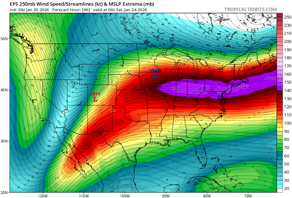
Best analog on this is Dec 2002... by far. Only difference is it's mid January meaning the Parent high has much colder air to work with. So a larger front end thump of snow/sleet followed by ZR. The transition zone will be much larger as well due to the depth of the cold air. I would like to get the STJ wave onshore (Think tomorrow night) before we get too excited, as the timing and overall size of the storm will be dependent on how much of that baha low ejects. Regardless, it will act to turn the upper levels from the southwest and put us in the right rear entrance region of the upper jet as soon as Friday. This will mean rising air and convergence, so an early start to the precip is likely given the isentropic lifting (cold dome building in and strong forcing moving in overhead from the southwest). Dec 2002 dropped close to 2 inches of precip, which is the potential of this one if we get a full ejection of the baha low. Will get more specific as we near, but definitely make plans for long term power outages and cold if you think you'll be in the ZR zone.
-
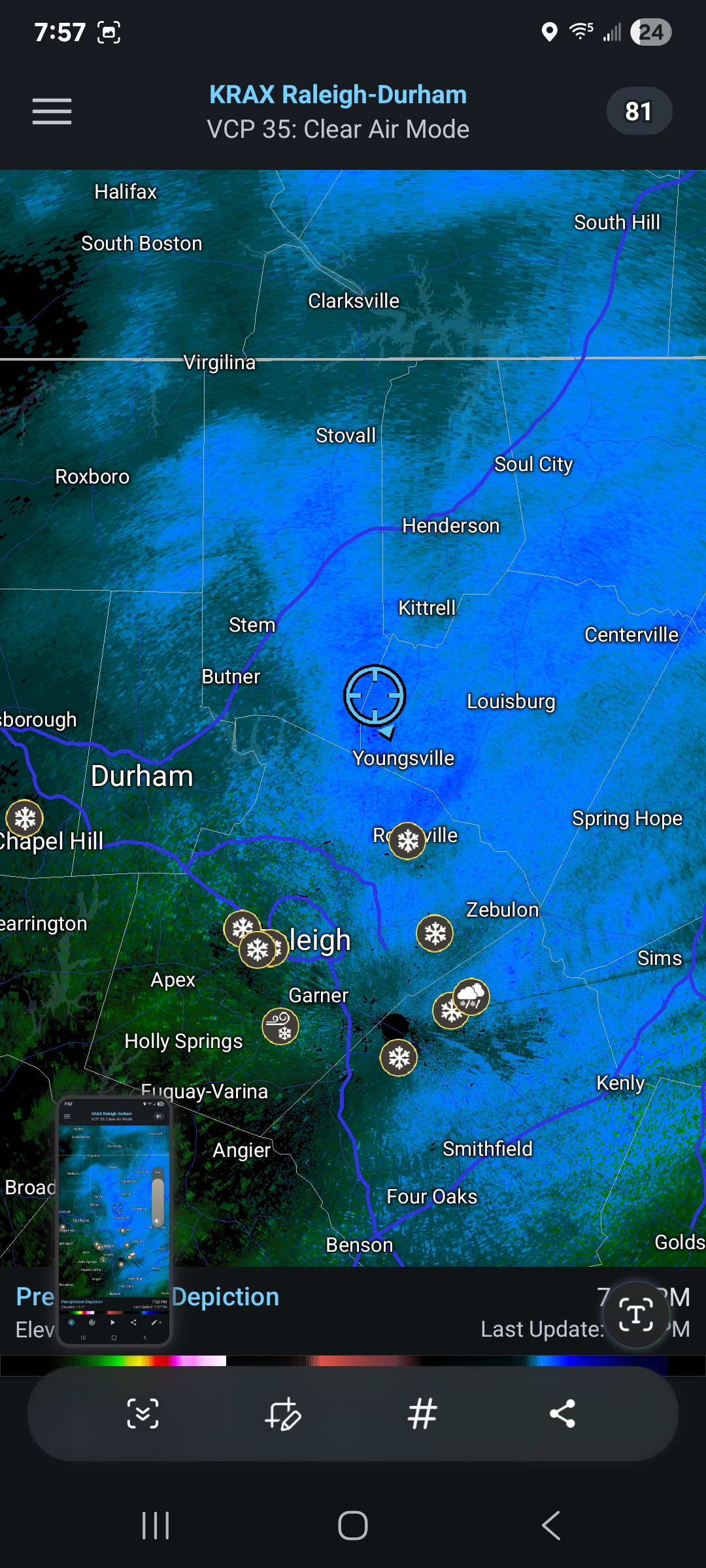
.25 in here in Franklinton
-
As wow said, no words needed on this one.... Like when a 10 walks in the room. But it is a Miller A/B hybrid. So we will likely battle ice or a changeover in NC. Classic split flow pattern out west. STJ wave with Arctic HP in place. Still a long way out. Would like to get this one inside of 5 days before getting overly excited. Checkout president's day 2 storm back in 2023 for a pattern comparison. But colder.
-
Regardless of the other indicies, the -AO is always the savior for us. Many times over, when it dips down good things always happen around here. Pattern suppression for the win.
-
Good burst right now
-
Prob 1/2" here in Franklinton with flurries and still some periods of -sn
-
Lol. I still like cold and snow.
-
This sounds like my life right now. Add in working from home and it's chaos.
-
32.3 here in Franklinton. Light snow right now. Has been off and on light snow. Got a dusting currently. WIll be interesting to see how long we can keep it going this evening.
-

Major Hurricane Melissa - 892mb - 185mph Jamaica landfall
HKY_WX replied to GaWx's topic in Tropical Headquarters
It's quickly reorganizing but going to run out of water before it can ramp back up too much. -
Major Hurricane Melissa - 892mb - 185mph Jamaica landfall
HKY_WX replied to GaWx's topic in Tropical Headquarters
It will be interesting to see if the ocean starts creeping up on that cam as the winds switch north. -
Major Hurricane Melissa - 892mb - 185mph Jamaica landfall
HKY_WX replied to GaWx's topic in Tropical Headquarters
I'm assuming it's just ESE of that location. It's facing the ocean, so that wind is probably coming from the ENE switching to N soon -
Major Hurricane Melissa - 892mb - 185mph Jamaica landfall
HKY_WX replied to GaWx's topic in Tropical Headquarters
That 50 mile wide swath of the eyewall will carve a path through the island unlike we've seen before. I bet satellite pictures in a few days will show it almost like a tornado path. Will be sad. -
Major Hurricane Melissa - 892mb - 185mph Jamaica landfall
HKY_WX replied to GaWx's topic in Tropical Headquarters
I think I am less worried this go around given the elevation. he can likely avoid the surge pretty easily down there. As long as he's in a reinforced concrete building he should be fine. -
Major Hurricane Melissa - 892mb - 185mph Jamaica landfall
HKY_WX replied to GaWx's topic in Tropical Headquarters
I can't convince myself to sign up for TikTok, even to watch streams of the strongest Hurricane landfall in history. -
Major Hurricane Melissa - 892mb - 185mph Jamaica landfall
HKY_WX replied to GaWx's topic in Tropical Headquarters
Where is he located? -
Major Hurricane Melissa - 892mb - 185mph Jamaica landfall
HKY_WX replied to GaWx's topic in Tropical Headquarters
I'm sure Josh or another chaser has a handheld barometer onsite. If so, we could have ground truth of the strongest or 2nd strongest landfall ever in the Atlantic basin. At least in recorded history. -
Major Hurricane Melissa - 892mb - 185mph Jamaica landfall
HKY_WX replied to GaWx's topic in Tropical Headquarters
https://x.com/iCyclone?s=09 -
Major Hurricane Melissa - 892mb - 185mph Jamaica landfall
HKY_WX replied to GaWx's topic in Tropical Headquarters
Per Twitter, he settled on a concrete masonry building up on a hill. Def safe from surge i'm sure, but will be battling the wind. There's a chance he might catch the 2nd strongest Hurricane landfall ever. Think about that for a second. Unreal. -
Major Hurricane Melissa - 892mb - 185mph Jamaica landfall
HKY_WX replied to GaWx's topic in Tropical Headquarters
Mind boggling. There are certain systems that defy the norms. This is def one of them. Not sure people are prepared for the scenes that will be coming out of Jaimaca. They've dogged the bullet so many times. Not this one. -
Major Hurricane Melissa - 892mb - 185mph Jamaica landfall
HKY_WX replied to GaWx's topic in Tropical Headquarters
Twitter BS -
Major Hurricane Melissa - 892mb - 185mph Jamaica landfall
HKY_WX replied to GaWx's topic in Tropical Headquarters
Not sure how much lower pressure the atmosphere can support down there. Assuming it can go close to 900mb. Just a sick setup. The depth of the warm water in that area is always off the chart. -
Major Hurricane Melissa - 892mb - 185mph Jamaica landfall
HKY_WX replied to GaWx's topic in Tropical Headquarters
The eye appears to have gotten a bit smaller on Sat. Not sure if the vdm will confirm or not. -
Major Hurricane Melissa - 892mb - 185mph Jamaica landfall
HKY_WX replied to GaWx's topic in Tropical Headquarters
12z EC/AI/Google Deep mind are pretty deadset on SW Jamaica (Would put the mid-point near White House, Jamaica). I don't see much variance among them today. Seems to be the spot.