

HKY_WX
-
Posts
3,246 -
Joined
-
Last visited
Content Type
Profiles
Blogs
Forums
American Weather
Media Demo
Store
Gallery
Everything posted by HKY_WX
-
I think my original analog of a December 2002 scenario in GA/Carolinas in January with colder air is pretty much going to work out. I know most of the state received 1.5-2 inches of precip in that system, which is what I would expect this time. The only saving grace could potentially be sleet as you all have noted. Otherwise it really would be catastrophic around here. A scenario worse than Dec 2002 really is scary to think about from a Power Outage/impact on life perspective.
-
Some decent trends on the NAM thus far. At this point, the entire baha wave is coming out, but a bit less northern energy interaction on the backend could be the difference between a front end thump of several inches of snow and a pure icestorm. Ideally you want to see that polar lob a bit further southeast than where it's at if you want snow. Some trends in that direction would be nice.
-
Pretty wild to see FRAM numbers that high. You can assume if we're getting 1.5ish QPF, that 1 inch is in the form of ZR and the rest sleet. Which means maybe an inch to 2 of sleet and an inch of ice on top. Pretty wild and devastating. If that were to happen, would likely be up there on the top 5 Icestorms of all time around northern Ga/N SC/NC.
-
NC IMBY - You will likely see the models lock in on the CAD more over the coming days. If surface temps are indeed in the teens, that will likely extend up quite a way. At least enough to produce sleet. Maybe even snow for longer than anticipated at the beginning.
-
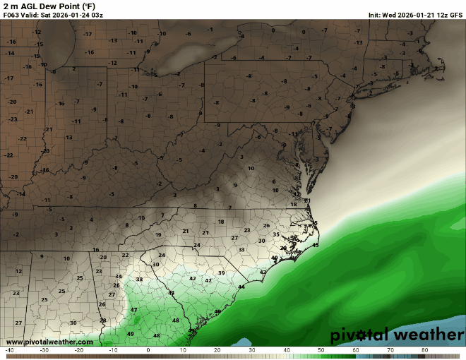
Checkout the dewpoints on the GFS with the backdoor CAD front. -8 at RDU by 18z Saturday right before the precip starts.
-
You can see the flip side in tn/al. This is likely.
-
-
The same. At one point, it has freezing rain in Greensboro with sfc temps at 12. Hour 90 and 96.
-
ICON would likely be the worst ice storm in the history of the Carolinas. Devestating. only real savior for us could be sleet at this point given how cold the sfc temps will be.
-
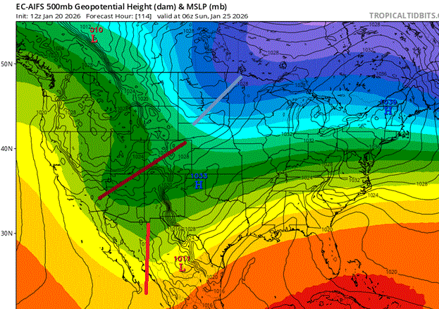
The main difference in the models overnight was the piece of energy over Alberta. It is acting as a kicker, scooping out the baha low and phasing in behind it. This allows the SLP to gain some latitude and get into the interior deep south before transferring offshore NC (This will happen due to the cold air physics). Pretty much a classic Miller B vs the more Miller A setup we were seeing 24 hours ago. For a snow scenario in the south, you ideally want that PV lob to be sitting over New England vs southern Canada. This will bring more WAA aloft (aka more ZR/IP). It could also setup a screw zone in the area around/outside the CAD pocket. (Or non-screw zone if you like have heat/power). NC IMBY -- Since this will be a 48 hour event, the hope for snow in NC, per my thinking yesterday, is we get a wave of WAA snow/overrunning far out ahead of the main SLP. This would allow for some snow before the WAA aloft kicks in as the SLP draws near. Otherwise this will be sleet/ZR fest for the favored areas. Highly skeptical this will be anything other an frozen/freezing precip in the NC CAD areas.
-
3 days of watching the correlation coefficient radar. Fml
-
I think the 00z Thursday models (Tomorrow night) runs will be a good time to start thinking more about details (ICE vs SNOW). That's when the Baha wave will be close to shore and the HP is getting into southern Canada.
-
Just for posterity.
-
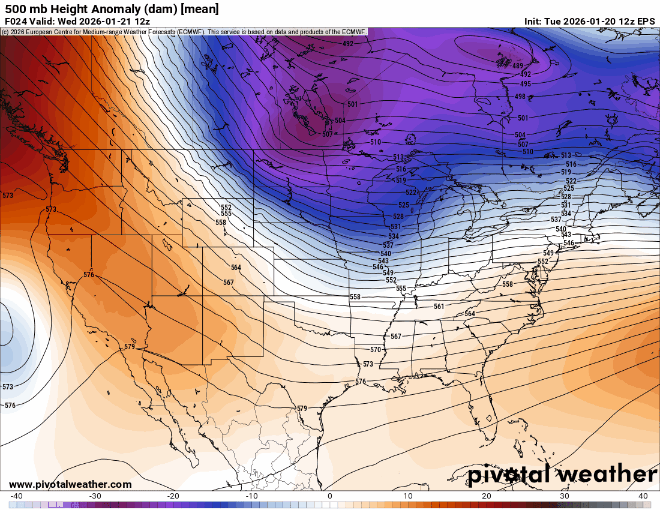
This is just complete model porn if you've researched and tracked these things for 25 years. Just absolutely SICK looking 500mb chart. I have NEVER seen one look this good for our area (GA/SC/NC) from just a general winter storm perspective, regardless of where you find yourself in the precip type category. Definitely soak in this next week.
-
Don't' go chasing shortwaves, please stick with the clown maps and Bastardi quotes you're used to.
-
Brick, just post the kuchera snowfall map. That takes into account thermals.
-
What map are you referring to?
-
For those in NC. Highly unlikely this storm will be all snow outside of the northern Mountains. Those hoping for that will likely be disappointed. Just the nature of CAD overrunning events drawing from STJ moisture. The best bet is we get such a strong front end thump that by the time it changes over it doesn't matter anymore. That has happened many times in the past.
-
Euro AI is out and it's pretty similar. Main difference is timing a bit slower on the baha low. Overall impact on real weather is negligible as far as QPF output. The ultimate big dog would be a full ejection of the baha low with the PJ wave coming in behind. This would essential result in a more prolonged version of the storm. Also likely increase QPF and a SLP closer to the Atlantic coast/warmer air aloft. Not usually the most likely scenario. It's normally a partial ejection (95% of the time).
-
Just search for Allan Huffman on Twitter.
-
You should be in this scenario. I honestly don't think it's too early to say that. Do yourself a favor and get ahead of the crowd. Back up heat, batteries, water, etc.
-
Classic overrunning. There will likely be a finger of precip that pushes out ahead of the main round due to the forcing aloft. When you have a dense cold dome at the surface and a screaming Jetstream at 300mb, it doesn't take much to generate precipitation. Notice it coincides with the surface front screaming in from the parent HP.
-
Yep. Allan is freaking out about this one and that's rare when it comes to these systems. This one could be epic. We're long overdue to be honest.
-
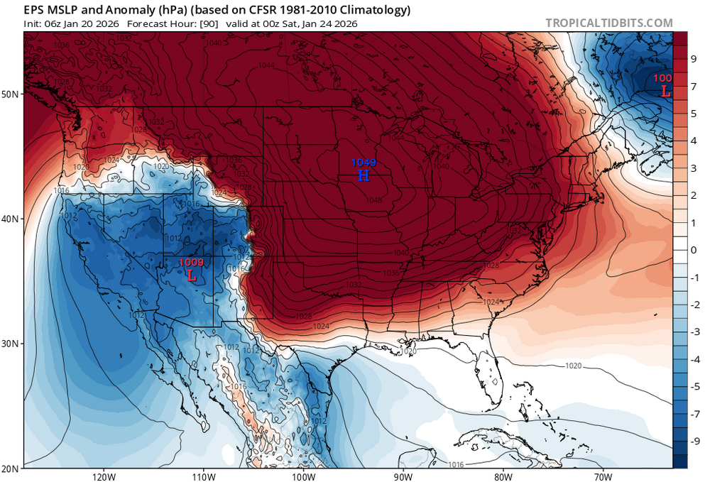
They may be right from a wish casting perspective in regards to the northern extent of the precip, but that's it. This only can go so far north with a 1050mb high sitting in Iowa starting Friday lol. This is not your average setup, it's very anomalous and will likely produce some very anomalous results.
-
Only difference is the parent high is much stronger. So more snow and sleet in NC (Think 20 degrees vs 30 degrees). It would move that ZR swath to central GA - midlands of SC.


