

HKY_WX
-
Posts
3,246 -
Joined
-
Last visited
Content Type
Profiles
Blogs
Forums
American Weather
Media Demo
Store
Gallery
Everything posted by HKY_WX
-
This hobby is comparable to a Crack addict
-

Southern Crippler - Get well soon Jimbo Storm Obs
HKY_WX replied to BooneWX's topic in Southeastern States
Heavy sleet here. Still 21 in Franklinton. Def a model bust on the cold eroding today which is pretty normal these mega CAD situations. The mega cold/low dewpoints really screwed NC/SC qpf wise since the dynamics were a bit northwest of us. Its amazing how each individual system is unique in different ways. -
Southern Crippler - Get well soon Jimbo Storm Obs
HKY_WX replied to BooneWX's topic in Southeastern States
Light freezing rain here west of Franklinton since about 9pm. 17 degrees. Has mixed back to sleet a few times. Ground is white and trees are glazed already. -
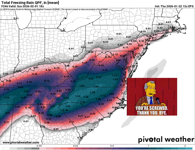
Yeah, QPF is not going to be an issue with this system in NC. The only area that will get dry slotted is the coastline counties. Most of the state will get 1.5 to 2inches of QPF easily.
-
Im tired bro. This is a fun but exhausting hobby.
-
The HRRR is the one we want to show it. The RAP is pretty much an outdated PO$hit.
-
HRRR lines up pretty well the GFS on a possible quick 1inch or 2 in the northern half of NC b/f the changeover.
-
There will be a dry slot but I think it will stay mostly along the counties that border the SC/NC coast, maybe 2 counties inland. This happens a lot with systems that skirt along the coastline. The dry slot with winter SLP's tends to follow closely along/ahead of the SLP track.
-
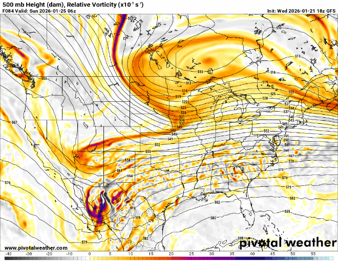
I don't see much other than noise on the models tonight. They have started to lock in on this one IMO. I'm a big analog guy, and as we all know the weather/climate tends to run in patterns. As stated a few times, this a very similiar setup to dec 2002 in a lot of ways. Not a perfect comparison, specifically b/c it was in early December, however it was one of the better ones I could find. The GFS is also reminding me a bit of 2/2/96 icestorm with brief changeover to snow at the end. That system was probably the worst icestorm in recent history for the foothills and also similar to this one with the STJ wave diving so deep into Mexico, along with some northern stream phasing and bitter cold following it. This will be a very memorable storm, so buckle up.
-
Pretty incredible that almost all of that precip in N SC is frozen/freezing.
-
GFS trend below. Main noticeable difference is the STJ cutoff trending south. This prevents such an early phase. It's apparent on the Water Vapor as well.
-
The beast has arrived. https://www.star.nesdis.noaa.gov/goes/sector_band.php?sat=G18§or=wus&band=09&length=24
-
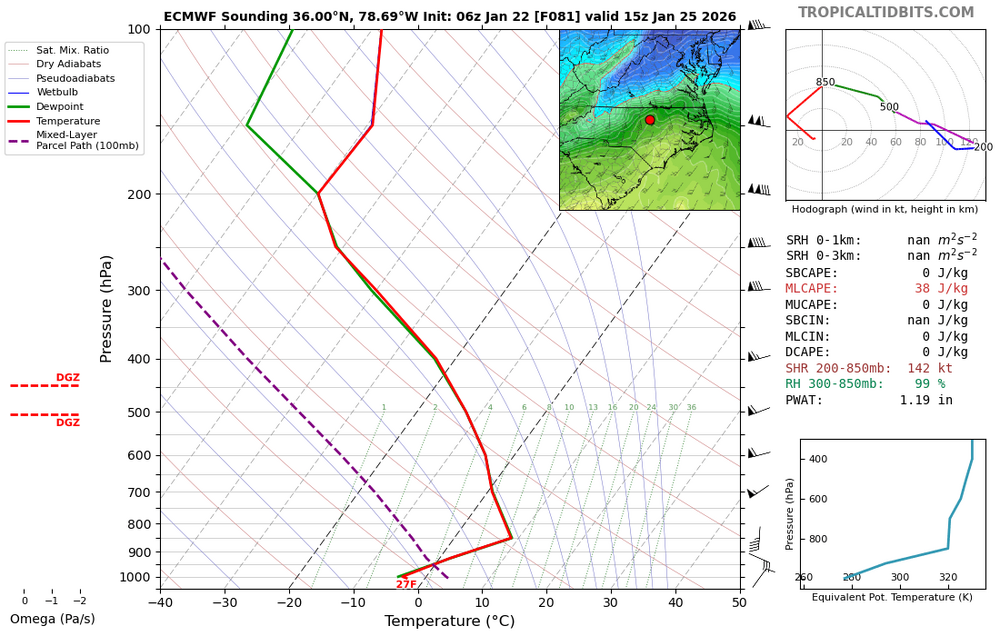
NAM is definitely sleet on this sounding at 18z for RDU. Only area above freezing is a small sliver from 850-800mb
-
NAM was always considered the best with thermals. I would pay attention to the NAM, HRRR, and some of the hi-res runs once we're inside of 60 hours when it comes to sleet vs ZR. It's really impossible to say at this point. There will, however, be an area that get's screwed with mostly ZR, on the periphery of the sleet area. I'm thinking that will likely be NE GA, N SC, and eastern NC.
-
-
Some of the hi res models will prob start showing it tomorrow at some point.
-
My guess is there will a "finger" of precip that streaks out ahead of the main SLP. It will be purely driven by the 150kt jet streak that will start setting up tomorrow night over the northeast. There will be a ton of virga. That first wave will likely be snow in the northern third of NC. The question is how long will it last? Prob not too long lol.
-
Several models are keying in on NE GA/NW SC as ground zero for freezing rain.
-
Fall/Winter Model Verification seems to favor a blend of GFS/EC ENS means.
-
The only saving grace for the Triangle on this map, could be that most of the ZR comes at the tail end when the temps have risen to the upper 20s. The ice accretion is still good, but not all that falls will freeze like it would in the mid to lower 20s. That said it would still be very bad.
-
Man... The amount of precip this thing is going to pump out can't be accurately depicted. This is such an insane jet configuration for STJ moisture. I would be surprised if several of us don't see over 2 inches of qpf.
-
The CAM models will be interesting once the system gets going over Texas. I don't think I've had a chance to actually look at them with a storm in progress.
-
Something to note, the radar is not going to look like it will over the northeast (with that beautiful sheet of snow/banding/etc). We are getting "rain" for all intensive purposes. It will be sleet/ZR, but we will be in the warm sector of the storm and it will be squally/showery/etc. Once you get above a couple thousand feet, it will be over 40 degrees.
-
We could get dry slotted and will likely still get over an inch of precip. There will be a dry slot over the coast due to the SLP location being so close to the coastline.
-
Yeah i've thought that for a few days. However if thermals at 850mb are 10C, then it could theoretically be correct. I have seen sleet before where the warm nose is much higher (think 700ish mbs). If the warm nose is only a few thousand feet off the sfc (850mb - 900mb), then the rain doesn't have time to refreeze before it gets to the sfc. This is why you can have ZR with sfc temps in the teens.


