thunderman
-
Posts
757 -
Joined
-
Last visited
Content Type
Profiles
Blogs
Forums
American Weather
Media Demo
Store
Gallery
Everything posted by thunderman
-
From a HAM radio friend of mine just a few moments ago:
-
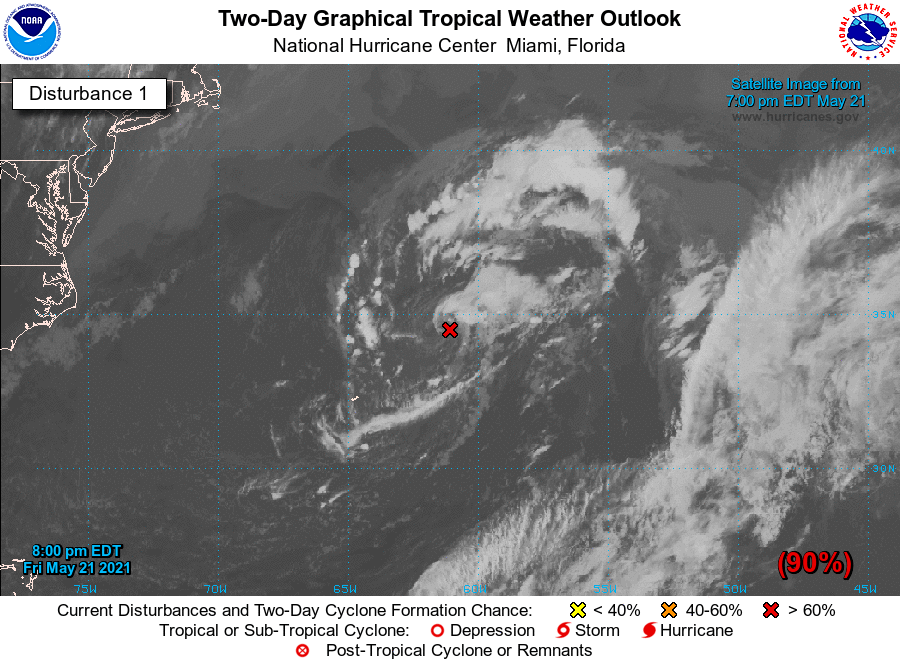
Still 90% with 8PM outlook

-

Feb Long Range Discussion (Day 3 and beyond) - MERGED
thunderman replied to WinterWxLuvr's topic in Mid Atlantic
Will have to see how this tracks. Could be very memorable ice event for parts of central Virginia and the southern Shenandoah valley. zr with temps in the 20s is bad news. -
Nice imagery from CIRA this evening!

-
Made it down to 32/29 last night and squeaked out a trace of ice. 33/32 now with light rain falling. Higher elevations of the Blue Ridge hanging onto upper 20s in some spots. Going to be a beautiful sight for anyone brave enough to travel over them this evening. I suspect Skyline Drive will be shut down for quite sometime after this :/
-
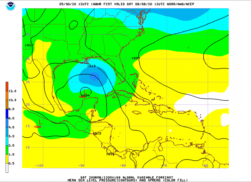
Getting really interested in what the next 7 days may hold in the Gulf.
-
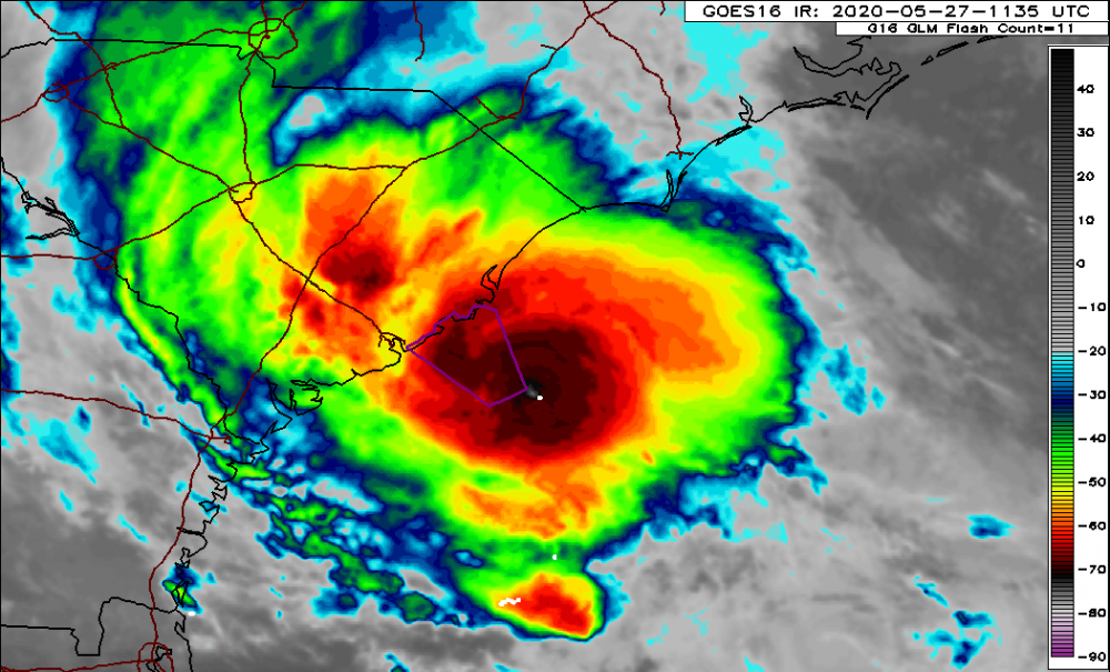
NHC has bumped this newest AOI up to 50% now.
-
Looks promising to me. Would not be surprised as all to see advisories on TS Bertha initiated this morning.
-
For far western areas along I-81 between I-64 and OKV An area of low pressure will move out of the northern Gulf of Mexico and up the east coast tomorrow and Wednesday. As it does, light precipitation will begin to overspread the area early tomorrow morning and will increase in intensity throughout the day … before beginning to taper during the overnight and possibly end as a period of snow Wednesday. Initially, there will be just enough cold air in place for some spotty flurries during the predawn hours Tuesday morning. Precipitation type will quickly shift towards freezing rain and sleet by 7:30am. As warmer air continues to move in with heavier precipitation through the day, freezing rain will transition to a plain cold rain. As typical, deeper and sheltered valleys will hold to freezing rain the longest … possibly into the late morning hours. Steady rain will decrease in intensity after midnight Tuesday night as colder air begins to filter in on the back side of the storm. Any leftover precipitation will begin to mix with sleet and snow again early Wednesday morning and eventually end as light snow/snow showers, as precipitation fully shuts off Wednesday afternoon. Wintry accumulations Tuesday will likely not amount to much at all … up to a coating of snow/sleet and up to 0.1” of ice accretion in the very coldest valleys (where freezing rain will hold on the longest). I do not expect roads to be that much of a problem tomorrow … icy spots should be limited to bridges and overpasses I think. This is not a great setup for a high impact freezing rain event … but that does not mean that slick spots cannot develop. Snow/sleet accumulations that occur Wednesday will likely total an inch or less for most. This part of the storm remains the most uncertain in terms of sensible weather. If colder air filters in more quickly than expected, then we will see a change over to snow earlier. There is also a question as to how much moisture will still be available and how efficient snowflake production will be aloft … both factors will have a big impact on the end result.
-
I have been really slacking as of late on the blogging ... hoping to fix that! Mediocre line of storms developed over the central Shenandoah Valley this afternoon and prompted a local blue box from Sterling around Charlottesville. There was a single report of wind damage in the city limits as well ... so congrats Sterling on the verification. Another line of storms lies further west from west-central Illinois through IND and down into LEX/central Kentucky ... high level blow off from this activity will likely stay clear of the area in at least the near term and allow for good rapid west to east clearing this evening. The clear skies early, excess moisture, and generally light winds will set the stage for some patchy overnight and early morning fog in areas that saw rain this afternoon (mainly the KSHD/KCHO area). This is not really anything new as this general area has seen patchy fog the last several mornings.
-
Flash Flood and Possible Isolated Tornado Threat Thursday - Saturday
thunderman posted a blog entry in thunderman's Blog
An area of low pressure is expected to come out of the Gulf of Mexico and up the east coast, while another disturbance approaches us from the West in the Thursday - Saturday time frame. These two systems will attempt to pump in a rich plume of moisture from the south and east, setting the stage for heavy downpours with any showers and thunderstorms that develop. No widespread severe weather is expected, but I would not rule out an isolated tornado with this system(s) ... with a somewhat favorable wind field, despite the lack of instability. Remember, you don't need a crap load of instability for rotating updrafts/supercells Still a lot of certainty, but the potential for the above is certainly there. 12z GFS from this morning valid 00z Friday. -
May 31, 2013 Oklahoma City Traffic/Chaser Debacle
thunderman posted a blog entry in thunderman's Blog
I generally stay away from opinion posts in this blog, but the events that transpired yesterday deserve attention. First, I think that it needs to be pointed out that chasers and spotters provide invaluable information to the National Weather Service in the form of ground truth. This is a concept that most of the general public (and even some meteorologists) on the East Coast do not fully understand. Without these folks burning their personal gas, warning lead times could be substantially different in some cases. With that said, there are quite a few amateurs out there that know just enough to find a storm and get themselves (and potentially others) killed. These people do not have a handle on basic storm structure and thus do not know how to attack a storm a properly. There are also the experienced guys that know better, but still conduct storm intercepts in an unsafe manner to get their video on CNN. Both of these groups are ruining what used to be a prestigious hobby. Now the million dollar question is what do we do about this problem on the chaser side of the things? It is a tricky question, but I believe that it is going to come down to law enforcement cracking down on obvious storm chasers breaking minor laws (slightly speeding, etc). Is it right? No, but I really do think that this is what is going to end up happening. Then you have the other side of spectrum that contributed to the traffic mess … broadcast meteorologists. Some of these broadcast meteorologists are completely incompetent and they simply have no business on television … much less in a high risk area such as Oklahoma. We are asking for a disaster when we have people, such as Mike Morgan at KFOR, that are telling people to attempt to drive away from a tornado after warnings are out. Keep in mind that this goes against pretty much every tornado/severe weather safety checklist. If you are going to leave, do so well before the storms fire (we are talking 10am). How these people are allowed to stay on the air with a NWA seal is beyond me. Put bluntly, they are an embarrassment to the profession. Broadcast meteorologists need to be held accountable for spewing such garbage, before a large number of people get killed because of inaccurate safety information. If an air traffic controller goes against protocol and puts the public’s safety in jeopardy then they are reprimanded. This should be no different for broadcast meteorologists during severe weather. I would love to see the operational meteorological community as a whole step up and do what needs to be done … hold these incompetent meteorologists accountable. -
Going to make this one short and sweet ... Longer range guidance showing signs of another round of 75-85 degree temps possible early next week for some?
-
There is a great competition called Virtual Storm Chase that has been given new life (for bragging rights only). This is the same competition that was started over on the old wxchat forums several years ago (mid 2000s). For those that do not know what it is, I have a attached a PDF copy of the rules below. It is a great learning experience for those interested in severe weather forecasting and a great way for even meteorologists to keep sharp. http://virtualstormchase.info The site "appears" to be broke ... but once you register (free) and login it works. Rules: Rules _ VirtualStormChase.pdf
-
Not much has changed. It is starting to look as if the warm sector will continue East in active form. Could see a multi day severe weather outbreak from the Plains to the Ohio Valley/dixie alley. People in KS, OK, MO, and AR really need to be paying attention to this. Original blog post on this: http://www.americanwx.com/bb/index.php/blog/8/entry-95-early-week-plains-severe-threat/
-
Looks to be a significant severe weather threat early next week. An area of low pressure is expected to develop and move off the Rockies … as usual with upper level energy approaching/crossing the Rockies. Ahead of this system, there will be an extended period of northward return flow off the Gulf of Mexico … setting the stage for a moist and unstable boundary layer as our system moves in around Monday. A dry line will develop across Western parts of Kansas, Oklahoma, and Texas. As the dryline moves East, forcing (dryline and upper trough) looks to become sufficient for the development of thunderstorms within moderate to large instability and long/open hodographs. If things hold, would likely be a moderate or high risk day from SPC … with violent/strong long track tornadoes possible across parts of Oklahoma and Kansas.
-
Light ... to at times moderate ... snow will continue into the evening hours, as the upper level low moves slowly Eastward. Despite the snow, accumulations have been tough to come by thanks to a combination of above freezing temperatures and the late March sun angle. However, as we move closer to sunset, the snow will accumulate easier (much like we saw yesterday evening) and we could see up to another inch I think in some places. Some slick spots could develop as well later this evening on roadways.
-
While still being a day 5ish event, it is not to early to start looking at some of the possible implications of various models. At this juncture, we generally have the GFS and the Euro book-ending a possibilities window that includes a cutter to Chicago and a more suppressed system that goes East of Hatteras For the most part been consistently left of the GFS ... with its ensembles a tad to the right of the operational Euro (but no where near the GFS). The 12z GFS Ensembles cut the difference with somewhat of a middle ground ... bringing the primary low into Ohio, with a coastal transfer. Depending on the amount of moisture return that is achieved in the warm sector, the operational GFS could be a notable severe weather event. And would keep QPF amounts across the DC/NOVA area on the light side with little possibilities for winter weather. The transfer with this solution simply happens too late to provide the lift for precipitation and wraparound of cold air. Then we have the Euro with it's more southern solution. It would mean a smaller spatial window for severe weather possibilities and a better chance for wintry weather for the area (especially west ... like we saw with the early March event). Given the time range and the placement of the the ensembles in the middle of the operationals I would expect to see some compromise towards the middle in terms of track over the next 1-3 days ... rather than an extreme on either side verifying. If I had to pick a solution verbatim from this mornings 12z suite for the heck of it, it would be the GEFS.
-
The area of low pressure that we are all watching for winter weather possibilities next towards next weekend, looks as if it may have quite the significant severe weather side as well on Thursday. The area of interest will be from east Texas into Dixie Alley. As we saw with the last event on Sunday, there looks to be a small area of sufficient moisture return along and ahead of the front across LA, MS, AL, southern AR, and east TX. This area of better moisture/theta-e looks to also be co-located with 50+ knts of mid/upper level shear with surface winds containing an easterly component … yielding large and open hodographs. It still remains to be seen how much forcing we get into this area. If storms can manage to stay semi-discrete and surface based then we could be looking at another round of tornadoes … with strong to violent tornadoes in the cards. Definitely need to keep an eye on this.
-
As I am sure most are aware, it looks like we will have significant to major nor'eater on our hands for the Thursday-Saturday time frame. While our friends up north look to clobbered, we will unfortunately be getting screwed. The main issue with this event for our area is going to be temps. High pressure to the north will keep cold air in place for the beginning of the event (Thurs night) ... with temps likely ranging from the upper 20s/around 30 (West of Blue Ridge) to lower/mid 30s (Leesburg, etc). Temperatures throughout the column look to be cold enough for widespread snow or sleet at the initial onset along and West of the Blue Ridge. As you move away from the Blue Ridge and closer to I-95, low level cold air looks a little weaker ... but enough so that some (if not most) of these areas that are removed from the Blue Ridge may only see a brief period of snow/pl/zr before quickly going over the plain rain as warm air continues to move in. Areas near and West of the Blue Ridge could get interesting and I actually wouldn't be surprised if they never change over to liquid precip in the usual cold spots. The only glitch here is that QPF amounts look to drop off significantly. I see no reason to really doubt this and it matches what I would expect given what I have seen countless times in the past with these systems. Overall this shouldn't be that big of a deal with only trace amounts of zr/sn/pl for those removed from the Blue Ridge. West of there (along and west of the Blue Ridge) could pick up a coating of sn/pl with a glaze of zr possible (especially just East of the Blue Ridge).
-
Yeah, was def 2011 I was thinking of (we got clocked good up here too ... most tornado warnings I have ever seen locally)
-
Oops, yup I put the wrong year! Fixed ... thanks for pointing that out!
-
First of all, I do not intend this blog to be a severe weather blog, but the weather around here lately has been boring. The term "Dixie Alley" gets tossed around a lot this time of year and it is never really defined beyond that. For those that aren't aware/aren't severe weather junkies, I just to briefly define it. "Dixie Alley" is essentially just a an extension of the traditional tornado alley into the Southeast and lower MS River Valley. In the late Winter and early Spring, the dynamics of the atmosphere and it's close proximity to a rich moisture source (the Gulf of Mexico) makes the area favorable for tornado outbreaks ... including strong and violent tornadoes. Some recent outbreaks in this region that you probably remember are the Super Tuesday Outbreak (Feb 2008) and the April 2011 Outbreak.
-
Possible Plains & MS River Severe Weather Episode Next Weekend
thunderman posted a blog entry in thunderman's Blog
Some type of severe weather threat is appearing more likely around the Saturday time fame from KS down into northern TX as a low develops on the flat side of the Rockies and works to setup/organize a dry line and triple point region. As the system pushes east, there is the potential to have a respectable cold front kicking into a moderately to highly sheared 60F+ Td warm sector along the MS River/Dixie Alley. Obviously too early to start boarding the train, but there is def potential for this system to produce a multi-day severe weather event ... possibly an outbreak ... from the Rockies east towards the MS River. Crappy moisture return is the biggest thing that could easily bust the event IMO. -
Evening/Overnight Tornado Threat in MS River Valley Region
thunderman posted a blog entry in thunderman's Blog
Eventual tornado threat will depend on how unified the current line of storms becomes. If it can manage to maintain some semi-discrete updrafts within the line, then all current data points towards a significant nighttime outbreak across AL/northern LA/western MS. The combination of boundary parallel upper SR winds and low level SR winds on the order of 20-40 knts has me personally a little worried about a too unified squall line ATTM for a significant tornado threat. Some guidance manages to keep the southern end a little less unified enough that it overlaps with favorable hodograph environments ... so around the LA/AR border area may end up being ground zero for this event.