thunderman
-
Posts
757 -
Joined
-
Last visited
Content Type
Profiles
Blogs
Forums
American Weather
Media Demo
Store
Gallery
Everything posted by thunderman
-

December 16-17, 2020 Winter Storm Obs/Nowcasting
thunderman replied to WxUSAF's topic in Mid Atlantic
18Z NAM could be a significant (and damaging) ice event for some out west along the Blue Ridge. Edited to correct model run time. -
Euro even flipping CHO to plain rain on the 12z run.
-
-
Only until tomorrow morning and then tomorrow night.
-
Not a bad spot to be right now, with the damming being modeled. Grab a stiff drink and see how it play out through the weekend. Potential for a descent event is there.
-
2020 Mid-Atlantic Severe Weather - General Thread
thunderman replied to Kmlwx's topic in Mid Atlantic
Manassas storm SVR warned.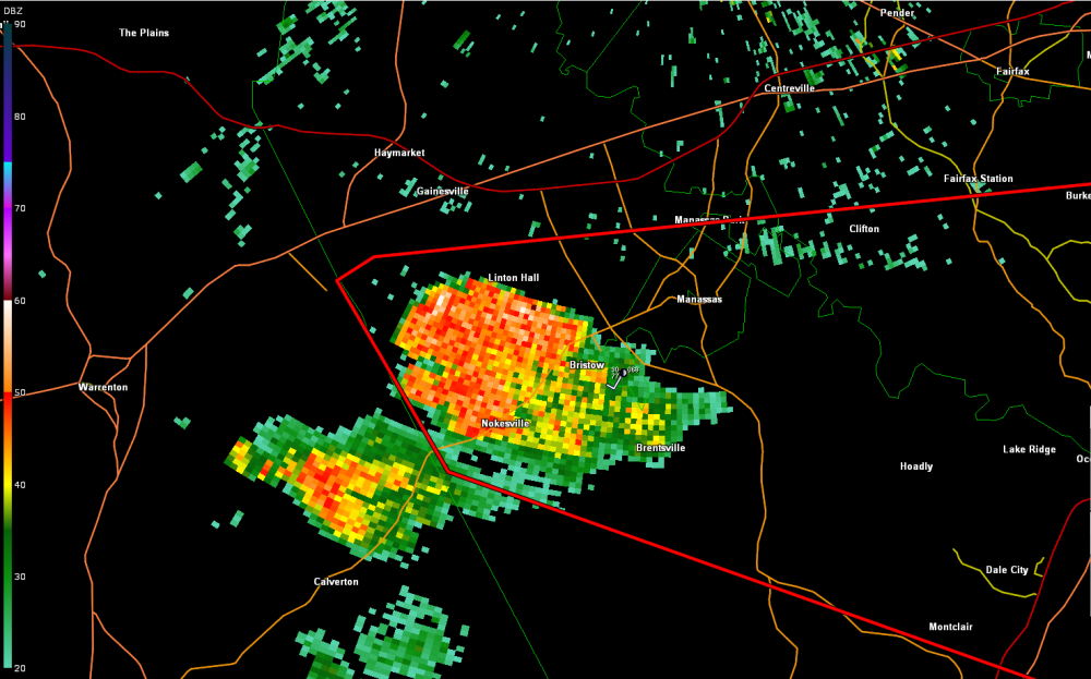
-
2020 Mid-Atlantic Severe Weather - General Thread
thunderman replied to Kmlwx's topic in Mid Atlantic
New initiation SW of Manassas looks to have become established. Could get interesting as it moves north and begins to interact with the outflow boundary. -
2020 Mid-Atlantic Severe Weather - General Thread
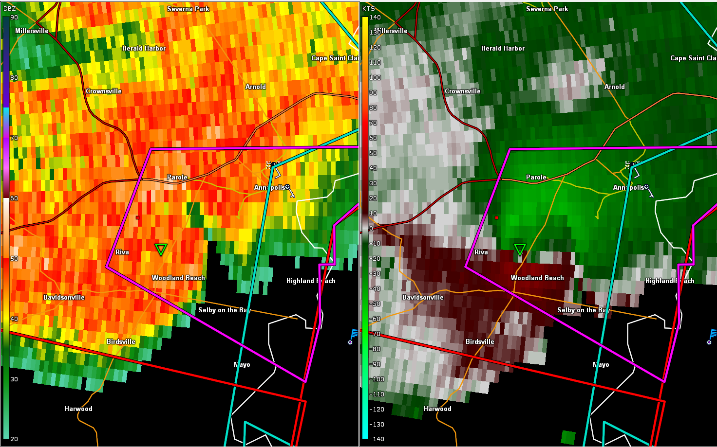
thunderman replied to Kmlwx's topic in Mid Atlantic
Very concerning circulation SW of Annapolis.
-
2020 Mid-Atlantic Severe Weather - General Thread
thunderman replied to Kmlwx's topic in Mid Atlantic
18z HRRR for Baltimore -
2020 Mid-Atlantic Severe Weather - General Thread
thunderman replied to Kmlwx's topic in Mid Atlantic
-
2020 Mid-Atlantic Severe Weather - General Thread
thunderman replied to Kmlwx's topic in Mid Atlantic
That 10% is still very much warranted IMO. If one of these discreet cells gets interacting with a local boundary, lookout. Red box by 4PM I think. -
2020 Mid-Atlantic Severe Weather - General Thread
thunderman replied to Kmlwx's topic in Mid Atlantic
I believe June 2008 may be the next one before that? That event was a bust. -
2020 Mid-Atlantic Severe Weather - General Thread
thunderman replied to Kmlwx's topic in Mid Atlantic
You don't see them often in these parts, but I wouldn't be completely surprised to see hatched tornado probs added by SPC tomorrow. 00z NAM soundings are wicked across northern VA and MD. Baltimore area: Northern VA: -
2020 Mid-Atlantic Severe Weather - General Thread
thunderman replied to Kmlwx's topic in Mid Atlantic
Depending on how long things stay discreet tomorrow, could be some pretty impressive supercells by Mid Atlantic standards. -
2020 Mid-Atlantic Severe Weather - General Thread
thunderman replied to Kmlwx's topic in Mid Atlantic
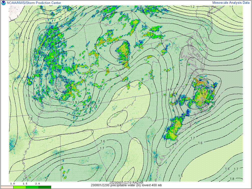
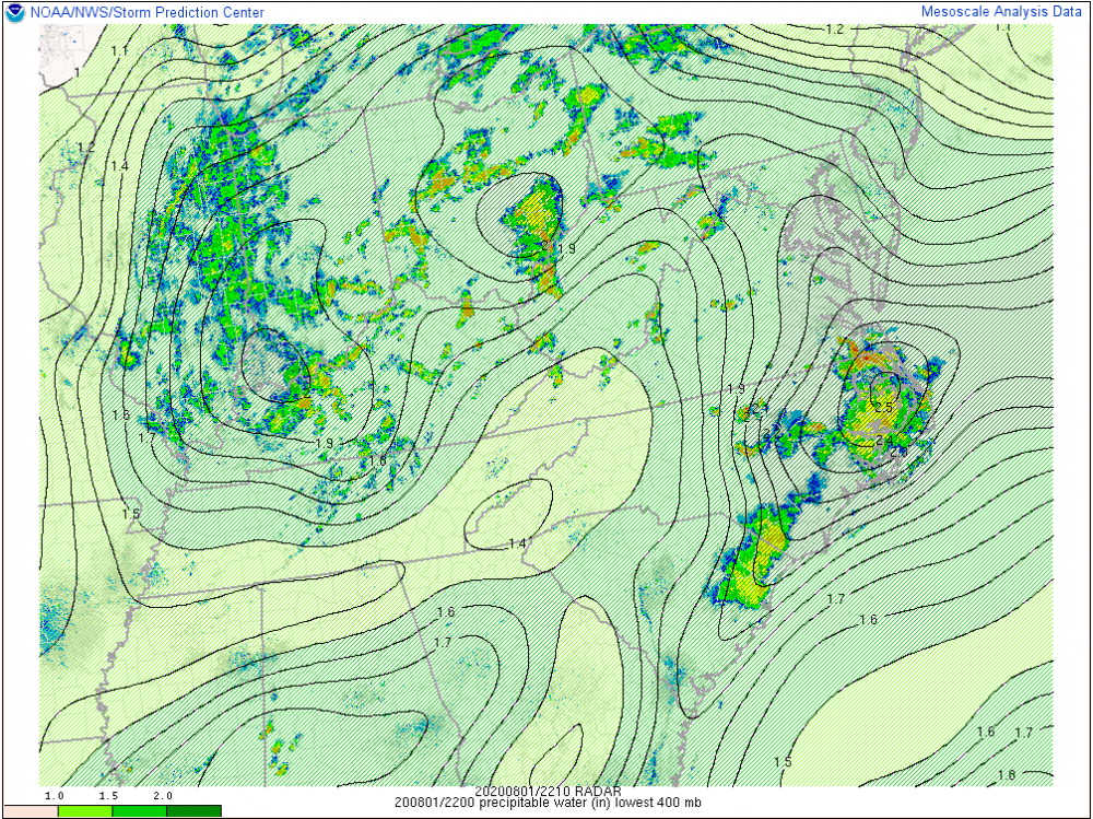
Severe threat should increase gradually a little each day through the weekend I think. That being said, I think flooding will be the biggest issue. Some impressive PWATS modeled in the coming days. -
2020 Mid-Atlantic Severe Weather - General Thread
thunderman replied to Kmlwx's topic in Mid Atlantic
Could have a good downburst or two tomorrow. Instability and shear should support a few organized updrafts. Heavy column with PWATS of 1.5+ should make make damaging winds and heavy rainfall the main threat. Notable flash flood threat, for places that get storms … which may end up being in distinct swaths, with storm motion and low level SRW roughly converging. 3 hour FFG is also under 2 inches most everywhere from Isaias. -
2020 Mid-Atlantic Severe Weather - General Thread
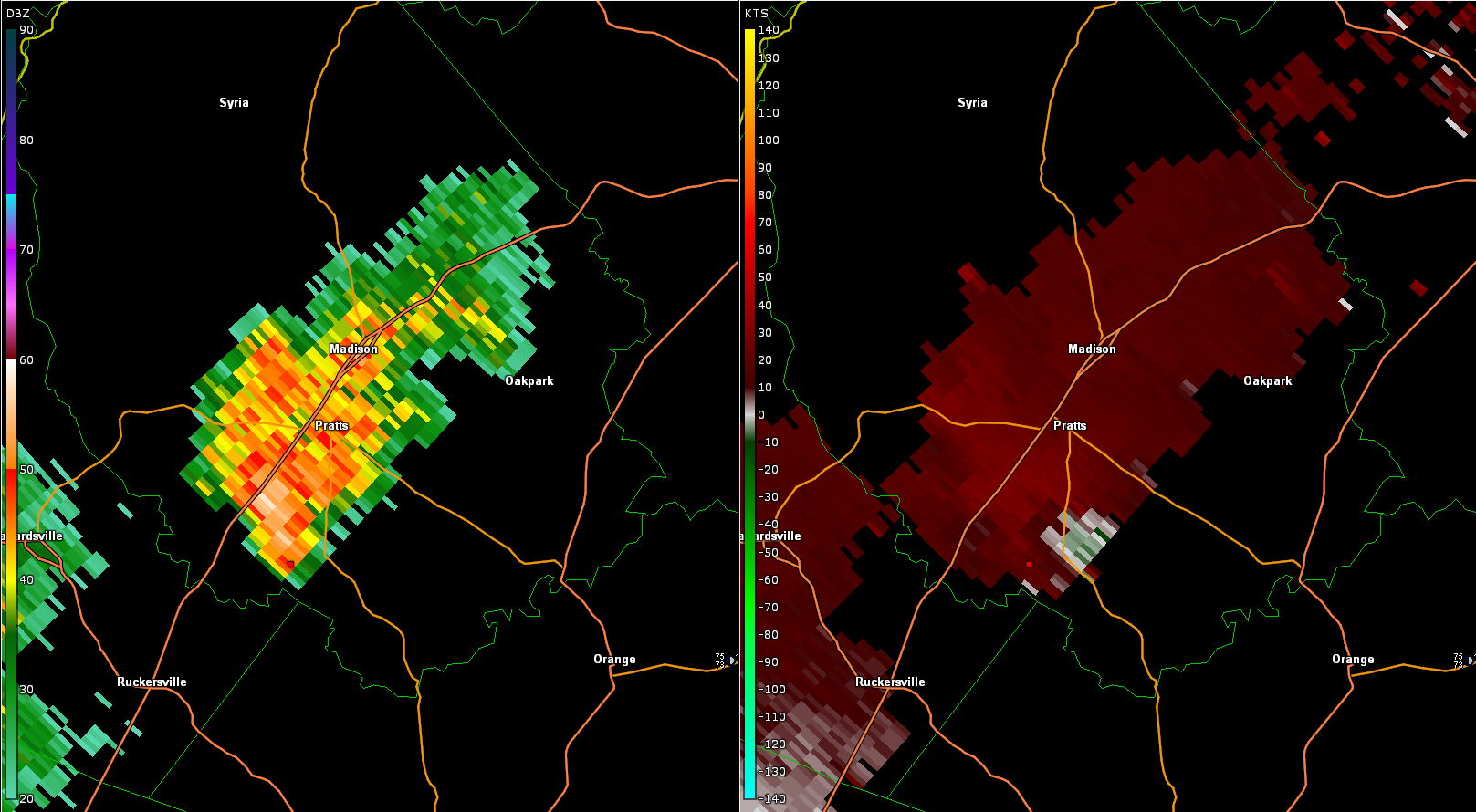
thunderman replied to Kmlwx's topic in Mid Atlantic
Madison County cell showing some weak rotation.
-
2020 Mid-Atlantic Severe Weather - General Thread
thunderman replied to Kmlwx's topic in Mid Atlantic
Interesting storm near Clear Springs, MD.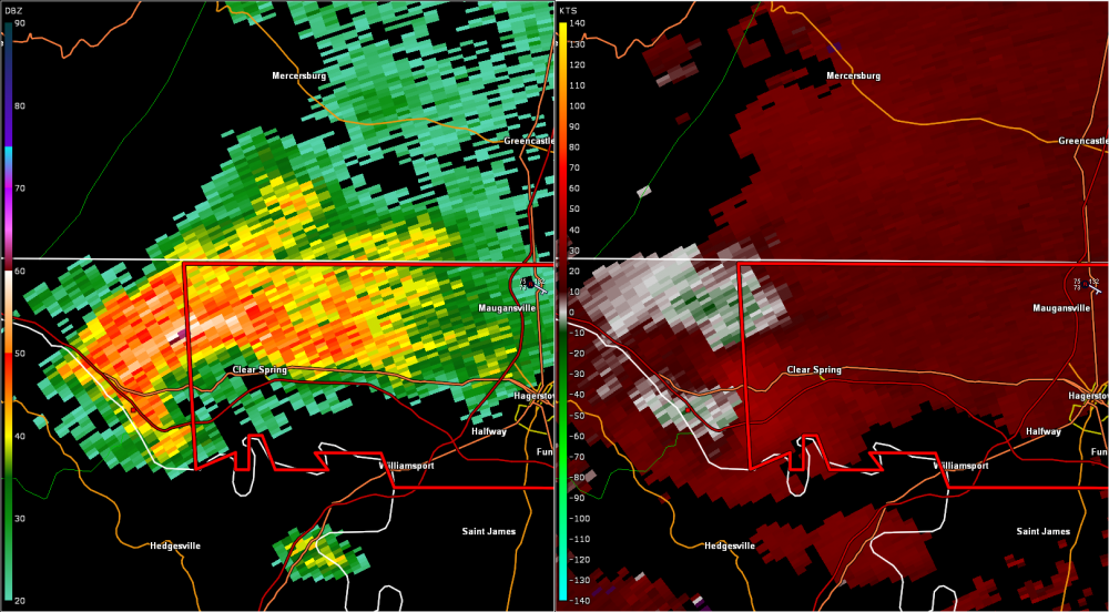
-
2020 Mid-Atlantic Severe Weather - General Thread
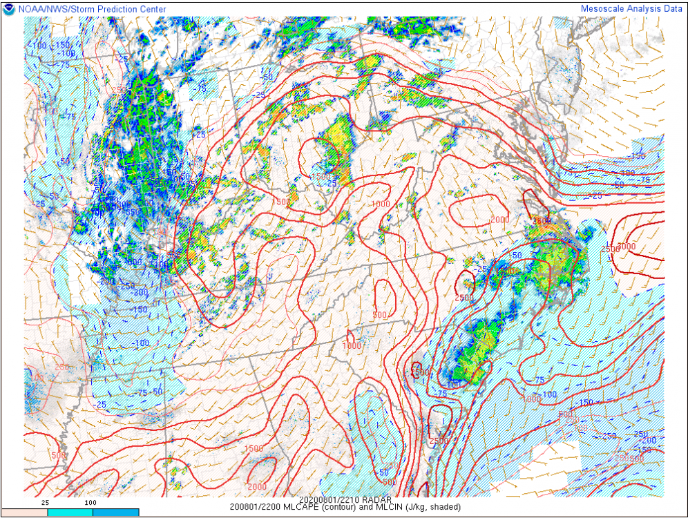
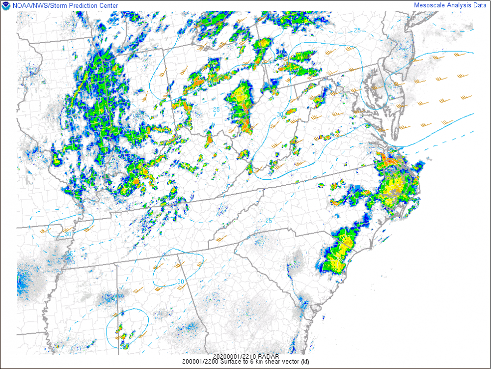
thunderman replied to Kmlwx's topic in Mid Atlantic
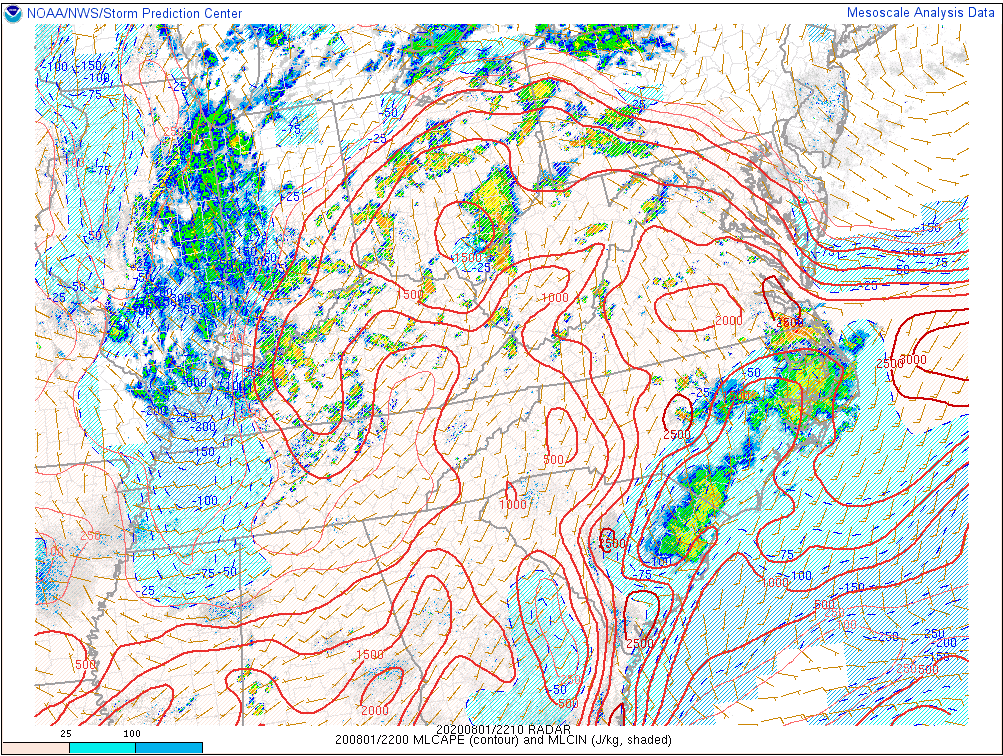
Mesoscale Discussion 1375 NWS Storm Prediction Center Norman OK 0605 PM CDT Sat Aug 01 2020 Areas affected...Eastern West Virginia...Northern Virginia...Southern Pennsylvania...Maryland...Delaware Concerning...Severe potential...Watch possible Valid 012305Z - 020100Z Probability of Watch Issuance...40 percent SUMMARY...A wind damage threat may develop across parts of the Mid-Atlantic this evening. Weather watch issuance could be needed across the region depending upon convective trends. DISCUSSION...The latest surface analysis shows a 1007 mb low in the Ohio Valley with a quasi-stationary front extending eastward from the low into southern Pennsylvania. South of the front, a moist airmass is in place with dewpoints in the lower to mid 70s. In response, the airmass has become moderately unstable and MLCAPE is estimated by the RAP to be in the 1000 to 2000 J/kg range across much of the moist sector. Scattered thunderstorms are ongoing across the Ohio Valley extending eastward into western Maryland and northern Virginia. This activity will continue to move eastward into the Mid-Atlantic over the next few hours. In addition to the instability, deep-layer shear on the order of 30 to 35 kt will be supportive of at least an isolated wind damage threat. However, the threat could be more substantial if convective coverage increases. If that occurs, weather watch issuance would need to be considered. ..Broyles/Hart.. 08/01/2020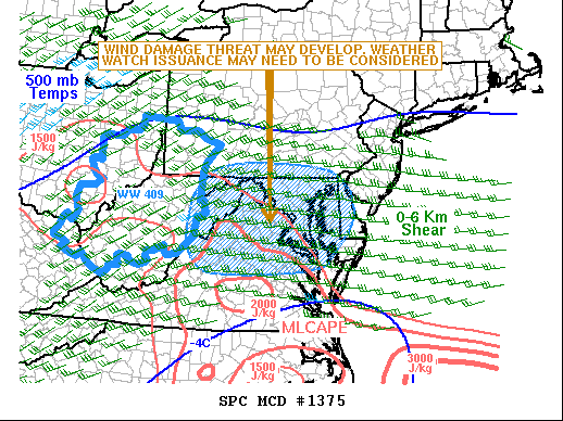
-
2020 Mid-Atlantic Severe Weather - General Thread
thunderman replied to Kmlwx's topic in Mid Atlantic
Not really a whole lot yet across central and northern Virginia (as expected). Convection starting to fire in central Virginia along I64 and I'd expect this to continue north over the next few hours. Good instability and wind profile for storms in a moist environment across central and northern parts of the state. I wouldn't be surprised at all to see a few SVR warned cells between now and 10PM and maybe a TOR warning or two.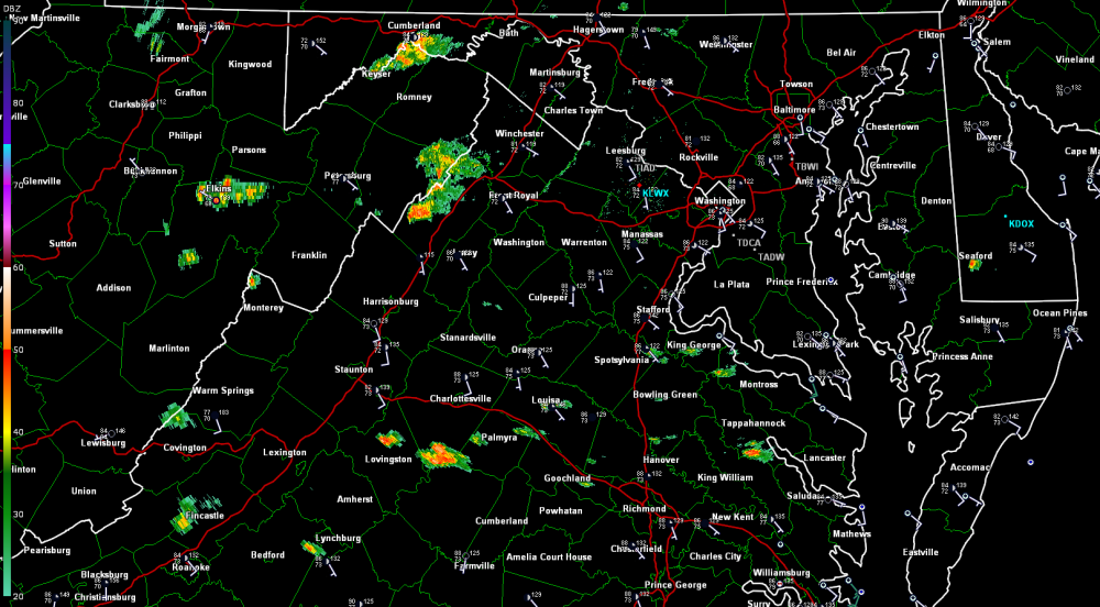
-
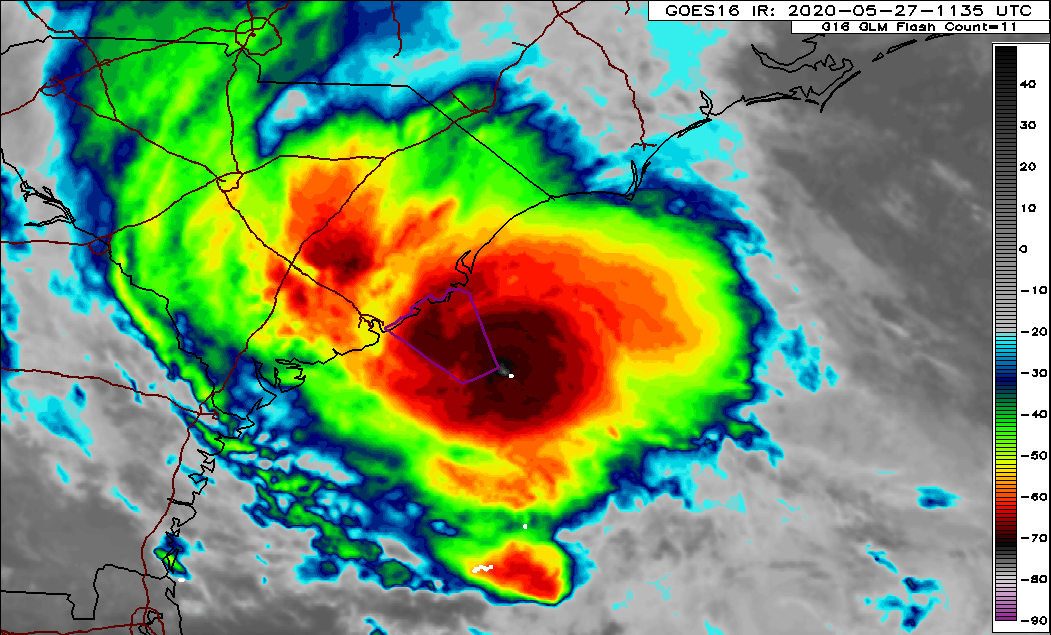
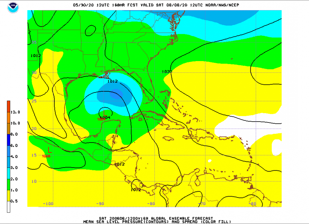
Getting really interested in what the next 7 days may hold in the Gulf.
-
NHC has bumped this newest AOI up to 50% now.
-
Looks promising to me. Would not be surprised as all to see advisories on TS Bertha initiated this morning.

-
For far western areas along I-81 between I-64 and OKV An area of low pressure will move out of the northern Gulf of Mexico and up the east coast tomorrow and Wednesday. As it does, light precipitation will begin to overspread the area early tomorrow morning and will increase in intensity throughout the day … before beginning to taper during the overnight and possibly end as a period of snow Wednesday. Initially, there will be just enough cold air in place for some spotty flurries during the predawn hours Tuesday morning. Precipitation type will quickly shift towards freezing rain and sleet by 7:30am. As warmer air continues to move in with heavier precipitation through the day, freezing rain will transition to a plain cold rain. As typical, deeper and sheltered valleys will hold to freezing rain the longest … possibly into the late morning hours. Steady rain will decrease in intensity after midnight Tuesday night as colder air begins to filter in on the back side of the storm. Any leftover precipitation will begin to mix with sleet and snow again early Wednesday morning and eventually end as light snow/snow showers, as precipitation fully shuts off Wednesday afternoon. Wintry accumulations Tuesday will likely not amount to much at all … up to a coating of snow/sleet and up to 0.1” of ice accretion in the very coldest valleys (where freezing rain will hold on the longest). I do not expect roads to be that much of a problem tomorrow … icy spots should be limited to bridges and overpasses I think. This is not a great setup for a high impact freezing rain event … but that does not mean that slick spots cannot develop. Snow/sleet accumulations that occur Wednesday will likely total an inch or less for most. This part of the storm remains the most uncertain in terms of sensible weather. If colder air filters in more quickly than expected, then we will see a change over to snow earlier. There is also a question as to how much moisture will still be available and how efficient snowflake production will be aloft … both factors will have a big impact on the end result.