

RU848789
-
Posts
4,002 -
Joined
-
Last visited
Content Type
Profiles
Blogs
Forums
American Weather
Media Demo
Store
Gallery
Everything posted by RU848789
-
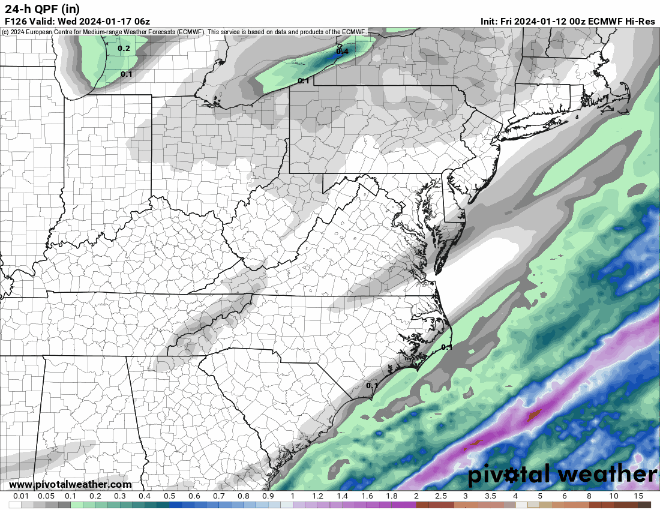
I'm missing something on the UK, since snowfall is 1-2" generally for Philly-NJ-NYC area, but the QPF is 0.3-0.4" and temps never really go above 32F except near the coast and soundings show the whole column under 32F for Edison and NYC, at least. It's almost like they forgot to calculate the snowfall, lol, as 0.3-0.4" QPF should be at least 3-4" of snow with <32F temps through the column. Anyone?
-
A friend of mine who is a former NWS met said on a sports message board I frequent that, "The NBM is the starting pt for all NWS fcsts." You can tell he used to write AFDs by his abbreviations, lol. Anyway here's the regional NWS forecast (which I like better than the separate Philly and NYC office maps) and the NBM 19Z forecast which are nearly identical. Would be nice for these to verify and break those friggin' <1" streaks and it would also be nice to get at least 1-2" or more of snow and have it be around all week, given temps will struggle to get above 32F through next weekend. And it would be awesome to get more snow then...
-
If you're disappointed in the dwindling snowfall amounts for this storm, go over to the January thread (GFS is huge for 1/19-1/20, which of course is still a week away).
-
Yes it is...
-
It still is the 2nd best model after the ECMWF (for 5-day 500 mbar pressure anomalies)... https://opensnow.com/news/post/weather-forecast-models-explained Edit: that graph is from 2019; currntly, UK and CMC are essentially tied for 2nd after the Euro, with the GFS, sadly, 4th as per the link below for the past month. https://www.emc.ncep.noaa.gov/users/verification/global/gfs/ops/grid2grid_all_models/acc/
-
I know the NAM is probably beyond its useful range when the precip hits, but it is interesting that the NAM and ICON have the surface low in similar positions Tuesday morning into the afternoon, when most of the precip falls, yet the NAM is much warmer/rainier for 95/coast (and even a fair amount NW of 95). And the RGEM is between the two. Any insight on why that is? TIA.
-
Actually, not true, as they have plenty of precip (large areas of 0.6-1.2" of QPF) 150+ miles SE of the coast. Just need to move it NW...
-
For me, this summarizes the surface trends well, showing the entire precip field moving NW about 150 miles vs. 0Z, bringing the 0.1-0.2" of precip to 95/coast and moving the 1" QPF line NW by ~150 miles, also. Still a ways to go, but the movement weneeded to see. 12Z also looks a little juicier, overall, too. And not that far off from the 12Z GFS precip field. Just need it to move another 150 miles NW...
-
UK good hit just NW of 95 and decent hit for 95 (with some sleet/rain probably), but mostly rain for the coast, as temps start out below 32F, quickly go over freezing and don't go below 32F again for 95 and SE of there until after the precip shuts off. Most of the precip is done by 1 pm Tues. Still a decent winter storm signal.
-
Walt - great post from someone who has actually had to make NWS forecasts with conflicting/limited data. The one thing I think many of us don't always think about is that the Euro is the best model - at predicting 500 mbar pressure anomalies globally (that's what the verification scores are based on - and not that that isn't important, but I've never seen "verification scores" for the various models, including the Euro on east coast winter cyclones. And that's where I think input like yours is really important based on experience and history. Doesn't mean the Euro can't be right, but one can't automatically think it is just because it's the "best" model. On the flip side, I think we've seen a bit of "confirmation bias" (wishcasting just a bit?) over the past 24 hours, where at 0Z 1/11, the Euro was somewhat of a snowy outlier and some were saying it was "leading the pack" and other models would move towards it, somewhat discounting the other 3 globals, but with regard to last night's 0Z runs, with the Euro being a non-snowy outlier, very few are saying the Euro is "leading the pack" and other models will move towards it. I'm no expert at all on synoptics, but I've done a lifetime of science where myself and my group had to evaluate scientific models and experimental results (chemical process development in pharma in R&D) and it was always difficult to not give in to confirmation bias, discarding or at least somewhat discounting data one "didn't like." Just some observations from the cheap seats - will be interesting to see how this one evolves and we're still 4+ days out with the main energy still way out in the Pacific and not sampled well (no ashore until Sat night/early Sun), plus how today's storm evolves will certainly influence how Tuesday's storm evolves. One thing for sure: the models will change, especially over the next 24-48 hours, but hopefully not much after that. That's why tracking is so fascinating.
-
Impossible to know what's going to happen, but I'd rather be in the camp with 3 of the 4 major global models than one, even if that one is the Euro - the best model by a bit, not by an overwhelming amount (and that accuracy is not measure on performance with east coast cyclones - I'd love to see that though).
-
While CMC is a hugger with lots of mixed precip after the initial snow thump and much faster than the GFS...
-
GFS classic Miller A with great track and temps in the mid/upper 20s for the whole storm, so this is one storm where we might get >10:1 ratios - see 10:1 and Kuchera maps...
-
The 18Z Euro Ensemble Mean snowfall axis moved back NW a decent amount vs. 12Z, perhaps indicating that the suppressed 12Z Op run was a bit of an outlier. It's possible. Hopefully we see a bit more consensus tonight, although as many pros have said, we might not get a great handle on Tuesday's event until we know the outcome of Friday's big storm and get the energy for Tuesday into the RAOB network so we can start with better initial conditions.
-
After last year's nearly snowless winter and this year's very slow start, it's easy to forget that 2000-2020 was the 2nd snowiest 20-year period in NYC's history (since 1869) and in New Brunswick, too, even with warmer than normal winters, on average. Presumably we got a bit lucky with better patterns and big storms which really helped those averages. Not quite sure, though, if that was somewhat of a statistical aberration and now we're poised for an era of less snow, as one would expect more often than not with a warming climate and warmer winters. We just don't have enough data yet...
-
Big improvements on the GFS/UK and even CMC (except for 95 and SE) for snow in our area, but the Euro is a suppressed whiff after several runs in a row of decent snowfall. It's never easy...
-
and 12Z CMC is snowy along/NW of 95 with precip issues SE of 95 - hopefully that won't be an issue with the cold air in place...
-
Surprised this hasn't been posted yet - GFS looking like the Euro now...
-
Euro pretty similar at 0Z vs. 12Z, apart from a ~50 mile shift SE in the snow shield, which is noise at 5-6 days out; this includes surface temps in the 20s throughout the event, so no mixing/melting issues, as modeled...
-
Two Mdt to high impact events NYC subforum; wknd Jan 6-7 Incl OBS, and mid week Jan 9-10 (incl OBS). Total water equiv by 00z/11 general 2", possibly 6" includes snow-ice mainly interior. RVR flood potential increases Jan 10 and beyond. Damaging wind.
RU848789 replied to wdrag's topic in New York City Metro
Thanks, but not a very satisfying answer they gave you. At the very least, they could state that it's a 3-day forecast. Will be curious to see if I get any different answer, but that's unlikely as I have no influence.- 3,610 replies
-
- 1
-

-
- snow
- heavy rain
- (and 5 more)
-
Two Mdt to high impact events NYC subforum; wknd Jan 6-7 Incl OBS, and mid week Jan 9-10 (incl OBS). Total water equiv by 00z/11 general 2", possibly 6" includes snow-ice mainly interior. RVR flood potential increases Jan 10 and beyond. Damaging wind.
RU848789 replied to wdrag's topic in New York City Metro
Ahhh, I now see what you meant about the slider bar, which I wasn't using. I simply clicked on the "entire period" button and up popped the graphic I copied/pasted in this thread, which does say through 1/13/24. However if one tries to use the slider bar, one only gets the first 3 days to work and it's grey after that. This is a problem for this page, as users will obtain info they think is for flooding through 1/13, when it's not. One other minor point: the ensemble river flooding graphic you posted doesn't note anywhere on the graphic what timeframe the graphic is for (it only gives the start time, not the end time). Again something that should be fixed. I send emails to the WFO webmaster a couple of times per year with minor issues like this, since you may not have noticed, but I occasionally dive into deep details, lol (the webmaster is the one they recommend contacting on the NWS-Mt. Holly webpage, but this one might be better sent to MARFC as you were suggesting, since it looks like the office just "hosts" that page from them) and I always get a reply and sometimes an answer. I still recall asking in 2016 if they could start doing snowfall forecast and accumulation maps regionally, instead of just maps for each WFO and the reply was they don't do that, but he'd pass the comments along and a few years later they appeared (my guess is more than a few folks made requests like that). -
Two Mdt to high impact events NYC subforum; wknd Jan 6-7 Incl OBS, and mid week Jan 9-10 (incl OBS). Total water equiv by 00z/11 general 2", possibly 6" includes snow-ice mainly interior. RVR flood potential increases Jan 10 and beyond. Damaging wind.
RU848789 replied to wdrag's topic in New York City Metro
The graphic I posted (quoted above) says, "through 1/13/24" right at the top of the graphic... -
Two Mdt to high impact events NYC subforum; wknd Jan 6-7 Incl OBS, and mid week Jan 9-10 (incl OBS). Total water equiv by 00z/11 general 2", possibly 6" includes snow-ice mainly interior. RVR flood potential increases Jan 10 and beyond. Damaging wind.
RU848789 replied to wdrag's topic in New York City Metro
Thanks for all the info/insights, but I still am curious about the difference, as the RFC forecast I posted clearly says through 1/13, so it's not cut off on 1/10. IMO, discrepancies like that are not good to have unless there's a really good reason for it (like the forecasts are simply different - but if they are, the NWS should explain that so users aren't confused).


