

RU848789
-
Posts
4,002 -
Joined
-
Last visited
Content Type
Profiles
Blogs
Forums
American Weather
Media Demo
Store
Gallery
Everything posted by RU848789
-
Two Mdt to high impact events NYC subforum; wknd Jan 6-7 Incl OBS, and mid week Jan 9-10 (incl OBS). Total water equiv by 00z/11 general 2", possibly 6" includes snow-ice mainly interior. RVR flood potential increases Jan 10 and beyond. Damaging wind.
RU848789 replied to wdrag's topic in New York City Metro
Speaking of uncertainty, look at the 12Z runs today so far. Just looking at Edison, the GFS has 1.8", the CMC has 6.7", the RGEM has 1.8" and the NAM has 4.6". Sure Holmdel or South Brunswick have generally less than 1" from those models, but parts of the 95 corridor (including NB to NYC) have similar modeled snowfalls as Edison. If that's not huge uncertainty, I don't know what is. Will the large snowfall amounts in the snowier models verify? Likely not, which is why the NWS and others have ~1" to 1-2" accumulations NE of NB along 95, but one has to acknowledge the uncertainty in the models and the forecasts made at least in part from these models.- 3,610 replies
-
- 3
-

-
- snow
- heavy rain
- (and 5 more)
-
Two Mdt to high impact events NYC subforum; wknd Jan 6-7 Incl OBS, and mid week Jan 9-10 (incl OBS). Total water equiv by 00z/11 general 2", possibly 6" includes snow-ice mainly interior. RVR flood potential increases Jan 10 and beyond. Damaging wind.
RU848789 replied to wdrag's topic in New York City Metro
I didn't say NYC would get 2-3" as a forecast - I was only talking about the 12Z GFS verbatim likely leading to 2-3" OTG in Central Park. -
Two Mdt to high impact events NYC subforum; wknd Jan 6-7 Incl OBS, and mid week Jan 9-10 (incl OBS). Total water equiv by 00z/11 general 2", possibly 6" includes snow-ice mainly interior. RVR flood potential increases Jan 10 and beyond. Damaging wind.
RU848789 replied to wdrag's topic in New York City Metro
I know, I said that. I included the 10:1 map, as that shows how much snow is "falling" to illustrate that it's not "mostly rain." Kuchera shows about 2" and I think that's underdone on the model verbatim, as column temps are below 32F on the model until the surface and given decent intensity (once snow starts accumulating, subsequent snow is not affected much by above 32F surface temps, as the actual surface is now 32F snow/slush), even NYC will accumulate maybe 2-3" from that 4.3" of snow falling. That's my informed opinion. I'm not a met, but I guarantee you a PhD in chem eng'g and 30+ years of doing hard science including a lot of work in heat transfer and physical chemistry phase transitions (crystallizations and melting - with several patents in the field for organic molecules) and a lifetime of observing high intensity snow accumulating when people said it wouldn't (think most March/April storms), means a little bit. This is not really a "meteorology" question (assuming the model is correct and no warm nose aloft, just above 32F at the surface), but a physical chemistry/rate question.- 3,610 replies
-
- 4
-

-

-
-
- snow
- heavy rain
- (and 5 more)
-
Two Mdt to high impact events NYC subforum; wknd Jan 6-7 Incl OBS, and mid week Jan 9-10 (incl OBS). Total water equiv by 00z/11 general 2", possibly 6" includes snow-ice mainly interior. RVR flood potential increases Jan 10 and beyond. Damaging wind.
RU848789 replied to wdrag's topic in New York City Metro
Could be at least partly elevation, as 10 miles W of CPK is still only ~50' in elevation, while 10 miles W of Boston is more like 150'. -
Two Mdt to high impact events NYC subforum; wknd Jan 6-7 Incl OBS, and mid week Jan 9-10 (incl OBS). Total water equiv by 00z/11 general 2", possibly 6" includes snow-ice mainly interior. RVR flood potential increases Jan 10 and beyond. Damaging wind.
RU848789 replied to wdrag's topic in New York City Metro
That's incorrect. Plenty of snow "falling" - it's just not clear how much of it will accumulate with 34-35F surface temps; during the thump part, NYC looks to be below 32F (barely) for the whole column, which is good. So verbatim there will be snow and if we can avoid a warm nose aloft (who knows?) I think a few inches (not the 4.3" on the 10:1 map below) is likely - as per the GFS, not a forecast.- 3,610 replies
-
- 1
-
-
- snow
- heavy rain
- (and 5 more)
-
Two Mdt to high impact events NYC subforum; wknd Jan 6-7 Incl OBS, and mid week Jan 9-10 (incl OBS). Total water equiv by 00z/11 general 2", possibly 6" includes snow-ice mainly interior. RVR flood potential increases Jan 10 and beyond. Damaging wind.
RU848789 replied to wdrag's topic in New York City Metro
6Z NAM not good. Do we call it NAM'd?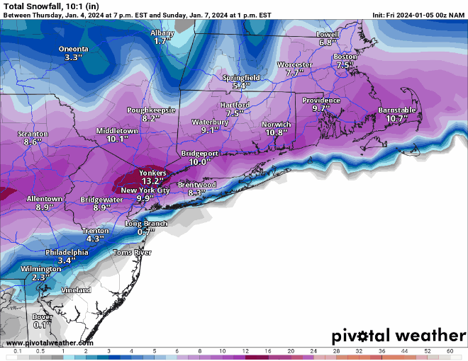
- 3,610 replies
-
- 1
-

-
- snow
- heavy rain
- (and 5 more)
-
Two Mdt to high impact events NYC subforum; wknd Jan 6-7 Incl OBS, and mid week Jan 9-10 (incl OBS). Total water equiv by 00z/11 general 2", possibly 6" includes snow-ice mainly interior. RVR flood potential increases Jan 10 and beyond. Damaging wind.
RU848789 replied to wdrag's topic in New York City Metro
The EPS mean was still good for 95... -
Two Mdt to high impact events NYC subforum; wknd Jan 6-7 Incl OBS, and mid week Jan 9-10 (incl OBS). Total water equiv by 00z/11 general 2", possibly 6" includes snow-ice mainly interior. RVR flood potential increases Jan 10 and beyond. Damaging wind.
RU848789 replied to wdrag's topic in New York City Metro
Remember, verbatim, the NAM is putting down 6-9" of snow in much of the region including the 95 corridor NE of about Trenton from about 6 pm Sat to 2 am Sunday in the initial thump, which translates to about 3/4-1" per hour rates and even if the surface temps are 33-34F (likely for 95), at that intensity melting will be minimal once the accumulation starts (as subsequent snow will be falling on 32F snow), so 10:1 is quite possible unless there is some significant melting going on in the column, which the model doesn't imply as soundings look to be below 32F for the whole column for this entire time even in places like Edison, NJ. In fact, with good dendritic growth likely with good saturation levels due to excellent lift, we could even exceed 10:1, IMO, especially inland. If the model is correct...- 3,610 replies
-
- 1
-
-
- snow
- heavy rain
- (and 5 more)
-
Two Mdt to high impact events NYC subforum; wknd Jan 6-7 Incl OBS, and mid week Jan 9-10 (incl OBS). Total water equiv by 00z/11 general 2", possibly 6" includes snow-ice mainly interior. RVR flood potential increases Jan 10 and beyond. Damaging wind.
RU848789 replied to wdrag's topic in New York City Metro
NAM'd again... -
Two Mdt to high impact events NYC subforum; wknd Jan 6-7 Incl OBS, and mid week Jan 9-10 (incl OBS). Total water equiv by 00z/11 general 2", possibly 6" includes snow-ice mainly interior. RVR flood potential increases Jan 10 and beyond. Damaging wind.
RU848789 replied to wdrag's topic in New York City Metro
I assume you've seen the latest WPC graphic on QPF from now through Wednesday. 3-6" for most of the EPA-NJ-SENY region would likely put many streams and river basins into major flood stage.- 3,610 replies
-
- 1
-
-
- snow
- heavy rain
- (and 5 more)
-
Two Mdt to high impact events NYC subforum; wknd Jan 6-7 Incl OBS, and mid week Jan 9-10 (incl OBS). Total water equiv by 00z/11 general 2", possibly 6" includes snow-ice mainly interior. RVR flood potential increases Jan 10 and beyond. Damaging wind.
RU848789 replied to wdrag's topic in New York City Metro
No, look at the NWS office maps side by side. One can't have a discontinuity of <1" on the NWS-Philly side of the Morris/Somerset borders next to 3-4" on the NWS-NYC side of that same border. Same thing with Middlesex adjacent to Union/SI (0" next to 1-2" in SI and <1" next to 2-3" in Union). There was no collaboration, clearly.- 3,610 replies
-
- 1
-
-
- snow
- heavy rain
- (and 5 more)
-
Two Mdt to high impact events NYC subforum; wknd Jan 6-7 Incl OBS, and mid week Jan 9-10 (incl OBS). Total water equiv by 00z/11 general 2", possibly 6" includes snow-ice mainly interior. RVR flood potential increases Jan 10 and beyond. Damaging wind.
RU848789 replied to wdrag's topic in New York City Metro
No, or at least it's nuts to have MMU getting ~1", while5 miles east of there the NWS-NYC has areas of Essex County in a 3-4" swath.- 3,610 replies
-
- 1
-
-
- snow
- heavy rain
- (and 5 more)
-
Two Mdt to high impact events NYC subforum; wknd Jan 6-7 Incl OBS, and mid week Jan 9-10 (incl OBS). Total water equiv by 00z/11 general 2", possibly 6" includes snow-ice mainly interior. RVR flood potential increases Jan 10 and beyond. Damaging wind.
RU848789 replied to wdrag's topic in New York City Metro
SIAP, but this cracked me up from Tomer Burg on being NAM'd...- 3,610 replies
-
- 2
-

-
- snow
- heavy rain
- (and 5 more)
-
Two Mdt to high impact events NYC subforum; wknd Jan 6-7 Incl OBS, and mid week Jan 9-10 (incl OBS). Total water equiv by 00z/11 general 2", possibly 6" includes snow-ice mainly interior. RVR flood potential increases Jan 10 and beyond. Damaging wind.
RU848789 replied to wdrag's topic in New York City Metro
Lots of NWS office inconsistency issues. The NWS has issued winter storm watches for a general 4-8" of snow for the Poconos, Lehigh Valley, Sussex, Warren, Morris, Passaic and NW Bergen, plus the Hudson Valley N of the Tappan Zee, but the discussions from the Philly and NYC offices are somewhat at odds, with the Philly office focusing on the warmth of the ocean and easterly winds keeping accumulations <1" for 95 from Philly to Woodbridge and SE of there, while the NYC office is saying things are trending cooler and now have 2-3" for places along 95 in NENJ (Union/Hudson) and NYC. I think they're all scrambling, so it's not worth focusing on their discussions, but their maps with inconsistencies are worth discussing - just look at the boundaries along Morris/Somerset where the Philly office has <1", while magically across the border into Essex/Union, the NWS-NYC has 3-6" of snow. Also, the NWS-NYC map has 8-12" amounts for their northern counties, but the watches only mention 5-8" so I think they have some work to do to get their forecast straight.- 3,610 replies
-
- 1
-
-
- snow
- heavy rain
- (and 5 more)
-
Two Mdt to high impact events NYC subforum; wknd Jan 6-7 Incl OBS, and mid week Jan 9-10 (incl OBS). Total water equiv by 00z/11 general 2", possibly 6" includes snow-ice mainly interior. RVR flood potential increases Jan 10 and beyond. Damaging wind.
RU848789 replied to wdrag's topic in New York City Metro
NAMed! Most of this falls in part 2 on Sunday afternoon...- 3,610 replies
-
- 8
-
-
-

-
-
- snow
- heavy rain
- (and 5 more)
-
Two Mdt to high impact events NYC subforum; wknd Jan 6-7 Incl OBS, and mid week Jan 9-10 (incl OBS). Total water equiv by 00z/11 general 2", possibly 6" includes snow-ice mainly interior. RVR flood potential increases Jan 10 and beyond. Damaging wind.
RU848789 replied to wdrag's topic in New York City Metro
Fascinating that every model has 6+ inches for Boston and the NWS has a forecast for 1". I understand models are not everything, but that seems a bit out of whack to me... -
Two Mdt to high impact events NYC subforum; wknd Jan 6-7 Incl OBS, and mid week Jan 9-10 (incl OBS). Total water equiv by 00z/11 general 2", possibly 6" includes snow-ice mainly interior. RVR flood potential increases Jan 10 and beyond. Damaging wind.
RU848789 replied to wdrag's topic in New York City Metro
zoomed in - such steep gradients make for easy forecasts, lol... -
Two Mdt to high impact events NYC subforum; wknd Jan 6-7 Incl OBS, and mid week Jan 9-10 (incl OBS). Total water equiv by 00z/11 general 2", possibly 6" includes snow-ice mainly interior. RVR flood potential increases Jan 10 and beyond. Damaging wind.
RU848789 replied to wdrag's topic in New York City Metro
Looking very similar to the 18Z euro...maybe a touch warmer/wetter; below is 18Z and 0Z Euro runs through 12Z Sunday for comparison.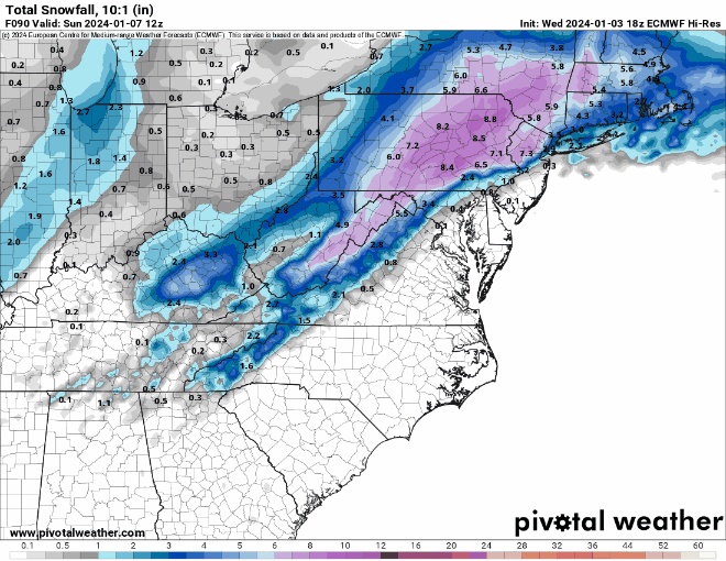
-
Two Mdt to high impact events NYC subforum; wknd Jan 6-7 Incl OBS, and mid week Jan 9-10 (incl OBS). Total water equiv by 00z/11 general 2", possibly 6" includes snow-ice mainly interior. RVR flood potential increases Jan 10 and beyond. Damaging wind.
RU848789 replied to wdrag's topic in New York City Metro
No it does not. It only takes into account the max air temp in the column and does a crude subtraction from a 10:1 ratio based on that. I've posted deeply and extensively on Kuchera. It does not address snow crystal formation/habit, aggregation while falling due to partial melting, intensity or the degree of melting at the surface due to ground temps or solar insolation, all of which can be important.- 3,610 replies
-
- 3
-
-
- snow
- heavy rain
- (and 5 more)
-
Two Mdt to high impact events NYC subforum; wknd Jan 6-7 Incl OBS, and mid week Jan 9-10 (incl OBS). Total water equiv by 00z/11 general 2", possibly 6" includes snow-ice mainly interior. RVR flood potential increases Jan 10 and beyond. Damaging wind.
RU848789 replied to wdrag's topic in New York City Metro
Yes, but I dislike Kuchera, as it's a lousy algorithm and while it's probably more realistic for this scenario, I prefer knowing how much snow is actually falling (assuming 10:1 ratio) and will do my own analysis of how much of that will likely accumulate, given how many variables there are that Kuchera doesn't take into account, plus some that aren't known well, like intensity.- 3,610 replies
-
- 1
-
-
- snow
- heavy rain
- (and 5 more)
-
Two Mdt to high impact events NYC subforum; wknd Jan 6-7 Incl OBS, and mid week Jan 9-10 (incl OBS). Total water equiv by 00z/11 general 2", possibly 6" includes snow-ice mainly interior. RVR flood potential increases Jan 10 and beyond. Damaging wind.
RU848789 replied to wdrag's topic in New York City Metro
Who do I have to pay to have this verify imby, lol? Incredible gradient from an inch or two (at the end of the storm) ~20 miles SE of me to about 8-10" at my house to over a foot 5 miles north of me. Insane.- 3,610 replies
-
- 2
-
-
-
- snow
- heavy rain
- (and 5 more)
-
Two Mdt to high impact events NYC subforum; wknd Jan 6-7 Incl OBS, and mid week Jan 9-10 (incl OBS). Total water equiv by 00z/11 general 2", possibly 6" includes snow-ice mainly interior. RVR flood potential increases Jan 10 and beyond. Damaging wind.
RU848789 replied to wdrag's topic in New York City Metro
Ignore it, like the NAM, at this range - it's a regional/mesoscale model...- 3,610 replies
-
- 1
-
-
- snow
- heavy rain
- (and 5 more)
-
Two Mdt to high impact events NYC subforum; wknd Jan 6-7 Incl OBS, and mid week Jan 9-10 (incl OBS). Total water equiv by 00z/11 general 2", possibly 6" includes snow-ice mainly interior. RVR flood potential increases Jan 10 and beyond. Damaging wind.
RU848789 replied to wdrag's topic in New York City Metro
Yep, he's fairly pessimistic on the 95 corridor and SE of there... -
Two Mdt to high impact events NYC subforum; wknd Jan 6-7 Incl OBS, and mid week Jan 9-10 (incl OBS). Total water equiv by 00z/11 general 2", possibly 6" includes snow-ice mainly interior. RVR flood potential increases Jan 10 and beyond. Damaging wind.
RU848789 replied to wdrag's topic in New York City Metro
Y'all are falling down on the job, lol. I've been away (playing disc golf) for several hours and I come back to a great GFS run that came out an hour ago and nobody posted this map? It's not the JMA or the Chilean model, c'mon. More seriously as many of us have been saying, let's see what we get at 18Z/0Z tonight after all the players are being well sampled by the RAOB network. Maybe the GFS will be an outlier, maybe not, but I'd rather have it in the snowier than before camp.- 3,610 replies
-
- 3
-
-
- snow
- heavy rain
- (and 5 more)
-
Two Mdt to high impact events NYC subforum; wknd Jan 6-7 Incl OBS, and mid week Jan 9-10 (incl OBS). Total water equiv by 00z/11 general 2", possibly 6" includes snow-ice mainly interior. RVR flood potential increases Jan 10 and beyond. Damaging wind.
RU848789 replied to wdrag's topic in New York City Metro
Thanks, that's very nice of you to say.