RU848789
-
Posts
4,002 -
Joined
-
Last visited
Content Type
Profiles
Blogs
Forums
American Weather
Media Demo
Store
Gallery
Everything posted by RU848789
-
The Euro is also about 18-24 hours "slower" than the GFS/CMC - lots to resolve before we really have a handle on this one...
-
Cat 5... BULLETIN Hurricane Lee Advisory Number 11 NWS National Hurricane Center Miami FL AL132023 1100 PM AST Thu Sep 07 2023 ...LEE BECOMES A CATEGORY 5 HURRICANE... ...DANGEROUS BEACH CONDITIONS EXPECTED TO DEVELOP AROUND THE WESTERN ATLANTIC THROUGH EARLY NEXT WEEK... SUMMARY OF 1100 PM AST...0300 UTC...INFORMATION ----------------------------------------------- LOCATION...17.3N 52.4W ABOUT 705 MI...1135 KM E OF THE NORTHERN LEEWARD ISLANDS MAXIMUM SUSTAINED WINDS...160 MPH...260 KM/H PRESENT MOVEMENT...WNW OR 295 DEGREES AT 14 MPH...22 KM/H MINIMUM CENTRAL PRESSURE...928 MB...27.41 INCHES
-
Good points, but on the last one, I'd say it's not an apples to apples comparison, as most winter storms, at least in the NE US, aren't fully formed entities that move for several days across the country, as they're usually the product of multiple pieces of energy coming together to form the ultimate winter storm, usually less than one day before the wintry weather begins. Hurricanes, by contrast, are mostly fully formed storms (at least once named) subject to a variety of steering factors, but I'd argue they're easier to predict 5 days in advance, as we've often seen with many tropical systems (not all, of course).
-
Good memory! Sam was forecast to hit 115 mph at 120 hrs... https://www.nhc.noaa.gov/archive/2021/al18/al182021.discus.001.shtml?
-
I said the exact same thing on FB when the first advisory came out and I've been tracking storms for a long time - maybe it has happened, but I don't recall it. Just looked back at a few of the big ones over the last 25 years (the ones on the NHC archive page) and Ida was the closest, with 110 mph predicted at 72 hours in the first advisory.
-
Question for you. In theory, wind gusts greater than 65 mph are usually needed to uproot mature trees and there was a report of 30 trees down on HHI, so I assume then, that at least at times and maybe in isolated locations, winds probably gusted over 65 mph, even if those speeds weren't recorded at the few stations on the island. So, was wondering what the max recorded gusts were on HHI (the public info statement from the NWS office doesn't show any gusts on HHI over 40 mph, unless I'm not aware of place names). Any input on that? Edit: looking at the PNS for the area, there were gusts of 69 mph on Tybee Island about 7 miles SW of HHI, 66 mph in Beaufort about 10 miles NE of HHI and 64 mph in Calibogue Sound about 1-2 miles SW of HHI. I just find it hard to believe that some places on HHI wouldn't have had 60+ mph gusts given reports of gusts that high surrounding the island, despite the reports of only ~35 mph gusts - looks more like the vagaries of wind variability and maybe instrument issues on HHI stations. https://forecast.weather.gov/product.php?site=NWS&issuedby=CHS&product=PNS&format=CI&version=1&glossary=1 https://www.wtoc.com/2023/08/31/not...island-residents-grateful-low-impacts-idalia/https://www.weather.gov/media/pqr/wind/wind.pdf
-
Looks like the beach just SSW of Perry is going to be ground zero for landfall in about 90 minutes, given the NNE motion at 18 mph with 125 mph winds, as the storm weakened a touch... Hurricane Idalia Tropical Cyclone Update NWS National Hurricane Center Miami FL AL102023 700 AM EDT Wed Aug 30 2023 ...CATASTROPHIC STORM SURGE AND DESTRUCTIVE WINDS OCCURRING IN THE FLORIDA BIG BEND REGION... ...7 AM POSITION UPDATE... Radar and Air Force Reserve Hurricane Hunter aircraft data indicate that an eyewall replacement cycle has begun. Idalia's maximum sustained winds are now estimated near 125 mph (205 km/h) with higher gusts. This change in wind speed does not diminish the threat of catastrophic storm surge and damaging winds. The estimated minimum pressure indicated by Air Force Reserve Hurricane Hunter aircraft data is 947 mb (27.96 inches). SUMMARY OF 700 AM EDT...1100 UTC...INFORMATION ---------------------------------------------- LOCATION...29.6N 83.8W ABOUT 55 MI...90 KM NW OF CEDAR KEY FLORIDA ABOUT 65 MI...105 KM SSE OF TALLAHASSEE FLORIDA MAXIMUM SUSTAINED WINDS...125 MPH...205 KM/H PRESENT MOVEMENT...NNE OR 20 DEGREES AT 18 MPH...30 KM/H MINIMUM CENTRAL PRESSURE...947 MB...27.96 INCHES

-
Just a 110C+ gradient from top to bottom, lol...
-
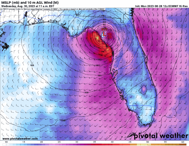
As feared and somewhat expected, the NHC is now forecasting that Idalia will be a 130 mph Cat 4 storm at landfall in the Big Bend area, about 20 miles ESE of St. Mark's and 35 miles NW of Steinhatchee (i.e., the middle of freakin' nowhere, with no towns within 10 miles of landfall including inland of there - which is not a bad thing) tomorrow morning around 8 am EDT. Other than the intensity, the only other change was a minor shift of the track about 10 miles further NW than earlier today at 5 pm. Good luck tomorrow to anyone in the path of this storm. Surprised nobody posted the discussion. Here it is... https://www.nhc.noaa.gov/text/refresh/MIATCDAT5+shtml/292056.shtml? Hurricane Idalia Discussion Number 14 NWS National Hurricane Center Miami FL AL102023 1100 PM EDT Tue Aug 29 2023 Satellite and NWS radar imagery show that Idalia is becoming increasingly more organized. The eye on the Tampa WSR-88D is becoming better defined and the cloud pattern on GOES 16 imagery consists of a growing Central Dense Overcast with a strong convective band over the eastern semicircle of the circulation. Reconnaissance aircraft measurements show that the central pressure is steadily falling and is now around 958 mb. Flight-level and SFMR-observed winds along with Doppler velocity data from the aircraft support an intensity of 95 kt for this advisory. Idalia is now moving faster toward the north or slightly east of north with a motion estimate of 010/16 kt. The hurricane is moving between a mid-level trough over the northwestern Gulf of Mexico and ridge over the Bahamas and Greater Antilles. The system is expected to turn north-northeastward within the next 12 hours, make landfall along the northeastern Gulf coast, and then move northeastward to eastward on the southern side of a mid-level trough moving off the northeast U.S. coast. The 12-hour track forecast point for this advisory has been nudged a bit westward, a little west of the model consensus, but close to the latest GFS and ECMWF solutions. It should be noted that some credible models, i.e. the HAFS-A and HAFS-B predictions, are even a little father west. After landfall, Idalia is expected to move near or along the coast of Georgia and the Carolinas in 24-36 hours. Uncertainty in the track forecast beyond 48 hours remains quite large, with some of the global models turning Idalia southward, while some of the regional hurricane models show the storm moving out to sea. Given the uncertainties, the official track forecast shows a slow southeastward motion in 4 to 5 days. Based on the current strengthening trend and the favorable thermodynamic and oceanic conditions, significant strengthening seems likely up to landfall. The new official intensity forecast calls for Idalia to reach category 4 strength at landfall. This is fairly close to the HAFS And HWRF regional hurricane model simulations. After the center moves back over the Atlantic, significant restrengthening is not anticipated at this time due to the expectation of strong vertical west-southwesterly vertical wind shear. Dangerous winds are likely to spread well inland near the path of Idalia due to its relatively fast forward motion. KEY MESSAGES: 1. Catastrophic impacts from storm surge inundation of 12 to 16 feet above ground level and destructive waves are expected somewhere between the Wakulla/Jefferson County line and Yankeetown, Florida. Life-threatening storm surge inundation is likely elsewhere along portions of the Florida Gulf Coast where a Storm Surge Warning is in effect. Residents in these areas should follow any advice given by local officials. 2. There is the potential for destructive life-threatening winds where the core of Idalia moves onshore in the Big Bend region of Florida, with hurricane conditions expected elsewhere in portions of the Hurricane Warning area along the Florida Gulf Coast. Strong winds will also spread inland across portions of northern Florida and southern Georgia near the track of the center of Idalia where Hurricane Warnings are in effect. Residents in these areas should be prepared for long-duration power outages. Damaging hurricane-force winds are possible in portions of eastern Georgia and southeastern South Carolina where Hurricane Watches are in effect. 3. Areas of flash, urban, and moderate river flooding, with locally considerable impacts, are expected across the Florida Big Bend, central Georgia and South Carolina, through eastern North Carolina into Thursday. FORECAST POSITIONS AND MAX WINDS INIT 30/0300Z 27.7N 84.5W 95 KT 110 MPH 12H 30/1200Z 30.0N 83.9W 115 KT 130 MPH...ON COAST 24H 31/0000Z 32.3N 81.3W 70 KT 80 MPH...INLAND 36H 31/1200Z 33.5N 78.6W 50 KT 60 MPH...OVER WATER 48H 01/0000Z 33.8N 75.0W 50 KT 60 MPH 60H 01/1200Z 33.5N 72.5W 50 KT 60 MPH 72H 02/0000Z 32.9N 71.0W 45 KT 50 MPH 96H 03/0000Z 32.0N 69.4W 45 KT 50 MPH 120H 04/0000Z 31.0N 68.4W 45 KT 50 MPH
-
Perhaps this is banter, but figured folks here might know the answers to this. I've always found it odd that the NHC will only do forecast predictions at 12 hour intervals, thus often "missing" key data points, like landfall -anyone know the rationale for that? Just look at the 5 pm advisory, which had a forecast for the storm to be up to 115 mph by 2 am tomorrow. However, due to the idiosyncracies of the NHC forecasts, the next published point is 2 pm tomorrow, after landfall when the storm is forecast to be at 85 mph. I don't know why, in situations like this, the NHC doesn't publish intermediate forecasts, i.e., at landfall around 8-9 am tomorrow along the Big Bend area. It's true that their discussion does say, "The 12-hour intensity forecast shows a 100-kt (115 mph) major hurricane. It is imperative to realize that Idalia is expected to continue strengthening beyond that time, possibly close to the 110 kt (125 mph) shown in the previous forecast, before the center reaches land," but how many people are reading the 5th paragraph down in the discussion vs. looking at the track graphics. Another pet peeve - why don't they put the windspeeds on the 12 hour timepoints on the track forecast instead of the inexact S, H, and M designations?
-
One never wants to "wish" a major hurricane on anyone, but if one thinks about the greater good, it's a bit lucky that this storm looks like it will hit the Big Bend area, the least populated coastal section of Florida, as per the graphic below. Still sucks for them, obviously.
-
This might help - the 0Z Euro moved landfall about 15-20 miles NW vs. 12Z today (was 976 mbar, 3 hours earlier)...
-
Can you elaborate on the physics of why a cyclone would be pulled east, relative to track forecasts, while approaching the west coast of FL? Obviously the track moved east relative to the forecast track with Ian, especially in the last 1-2 days before landfall (which is where we are now), but one could imagine many reasons for such shifts. Thanks.
-
Idalia really looking much healthier over the last several hours - much more concentric convection around the center, as the shear has obviously eased somewhat. But still a TS... Tropical Storm Idalia Discussion Number 10 NWS National Hurricane Center Miami FL AL102023 1000 PM CDT Mon Aug 28 2023 Idalia is producing intense bursts of convection near the center, with an overall comma-shaped cloud pattern along with a dry slot over the western part of the circulation. Upper-level outflow is restricted over the northwestern quadrant. Radar images from the Meteorological Service of Cuba show a partial eyewall forming. Flight-level and dropwindsonde data from NOAA and Air Force aircraft indicate that Idalia is very near hurricane strength. The maximum winds are set again to 60 kt for this advisory. The system has moved a bit slower than earlier today with an initial motion estimate of just slightly east of due north at around 7 kt. Idalia should be steered northward along the western side of a mid-level ridge and then turn north-northeastward due to a trough to its northwest. This track will take the center across the northeastern Gulf coast on Wednesday morning, and over northern Florida and southeastern Georgia thereafter. In 2 to 3 days, a mid-tropospheric trough moving off the eastern U.S. coast will likely cause the tropical cyclone to turn northeastward to eastward off the coast of the Carolinas. The official track forecast for this advisory is essentially the same as the previous one. This is near the middle of the track guidance, which are fairly tightly clustered, with the GFS on the left side and the ECMWF on the right side. Although Idalia is currently experiencing some moderate northwesterly vertical wind shear, the dynamical guidance indicates that the shear will lessen while the system is over the eastern Gulf of Mexico. This, along with a conducive thermodynamic atmospheric environment and high oceanic heat content, should cause Idalia to strengthen rapidly in the 12- to 36-hour time frame. The official intensity forecast, like the previous one, shows the system becoming a major hurricane before landfall along the Florida Gulf coast. This is in general agreement with the regional hurricane hurricane models, HAFS and HWRF, but above much of the other intensity guidance. Idalia is forecast to move into an area that is highly susceptible to storm surge, and regardless of the cyclone's specific landfall intensity, there is increasing confidence that a significant storm surge event will occur. KEY MESSAGES: 1. There is a danger of life-threatening storm surge inundation along portions of the Florida Gulf Coast where a Storm Surge Warning is in effect, including Tampa Bay and the Big Bend region of Florida. Inundation of 8 to 12 feet above ground level is expected somewhere between Chassahowitzka and Aucilla River. Residents in these areas should follow any advice given by local officials. 2. Hurricane conditions are expected within portions of the Hurricane Warning area along the Florida Gulf Coast, with the potential for destructive winds where the core of Idalia moves onshore. Strong winds will also spread inland across portions of northern Florida near the track of the center of Idalia. 3. Heavy rainfall from Tropical Storm Idalia is expected across portions of western Cuba and may produce areas of flash and urban flooding as well as landslides. Areas of flash and urban flooding, some of which may be locally significant, are expected across portions of the west coast of Florida, the Florida Panhandle, and southern Georgia Tuesday into Wednesday, spreading into portions of the eastern Carolinas Wednesday into Thursday. FORECAST POSITIONS AND MAX WINDS INIT 29/0300Z 22.0N 85.0W 60 KT 70 MPH 12H 29/1200Z 23.7N 85.0W 75 KT 85 MPH 24H 30/0000Z 26.2N 84.6W 90 KT 105 MPH 36H 30/1200Z 29.0N 83.7W 105 KT 120 MPH 48H 31/0000Z 31.5N 81.6W 50 KT 60 MPH...INLAND 60H 31/1200Z 33.2N 78.8W 50 KT 60 MPH...OVER WATER 72H 01/0000Z 34.0N 76.0W 50 KT 60 MPH 96H 02/0000Z 33.5N 72.0W 45 KT 50 MPH 120H 03/0000Z 33.0N 70.0W 45 KT 50 MPH
-
I see the HRRR near surface smoke forecast graphics on Pivotal, but they only go out to 48 hours (every 6 hrs); is there any decent smoke forecast model that goes out maybe 5-7 days that is available on-line? Thanks.
-
Fairly late-in-the-season cold snap with freeze warnings (dark blue) up for the Poconos, Sussex, W. Passaic and the Hudson Valley N of the Tappan Zee (and almost everywhere N/W of there) and frost advisories (light blue) up for Morris, Hunterdon, Warren, and much of the rest of NE PA. Strong high pressure, clear skies and diminishing winds, allowing for strong radiational cooling will send temps plummeting below 32F in the warning areas and near 32F in the advisory areas. Could also possibly see scattered frost in areas like NW Somerset and N Bergen. Bring in any tender vegetation. Fortunately, the red flag warnings for fire risk for much of SNJ/Pine Barrens come down at 8 pm tonight, as winds die down. Apart from some showers on Saturday, our stretch of fantastic weather looks to continue through the end of next week.
-
Why wouldn't I have wiped the board after 6 hours? One is supposed to do that and combine measurements.
-
Hey - did you measure at all? I'm not 100% sure what to do. We had about 0.6" on the board and most of the grass and the 1" on the car I took a pic of (and not much on some other lawns that were likely more in the sun), when I left around 5:15 pm to go to the RU game and got back around 9:30 pm and checked the board, which I had wiped before I left, and had another 0.4" on it, so I'm thinking of calling it an even 1.0". I was monitoring the radar after I left and it looks like Metuchen stayed pretty well under that band for a few hours after I left. I also see a report of 1.4" from Edison, so 1.0" seems reasonable. Thoughts?
-
here's the pic of 1" on the car. So odd. Still at 1/2" on the board, as intensity has let up a little, so some melting while falling. About to head to the bar and then the RU NIT game, so y'all are on your own...have fun...
-
We're up to 1/2" on the board on the lawn and the trees have about 1/2", while my undisturbed car in the shade has almost 1" on it and nada on pavement. I'm recording 1/2" right now, since the car is definitely an outlier - I've almost never seen this kind of difference before and I'm sure it's due to the car top being just slightly colder than the ground/board. Still 32F and coming down moderately, so we could get to 1" if that band stays over us (we'll be right on the eastern edge of it). Most years I wouldn't care much about every 1/4" but this winter is different.
-
If you're getting the moderate to close to heavy bands we're in now and others who also have had little snow this winter appear to be in, get yourself outside and walk around in it. It's a beautiful day - yeah it sucks that most of it has melted, but even falling snow with big flakes is very cool to see and we might not see any more flakes until next winter. Or 2026.
-
After about 4 hours of light to moderate snow at 33-34F, with a few light dustings established and then melted quickly as intensity lessened, just now we're finally getting sustained moderate snow (maybe 3/8 of a mile visibility (maybe 600-700 yards) at 32F and we now officially have a "full dusting" or "light coating" (whatever that is, lol) on the colder surfaces (and a good 1/4" on trees, but that doesn't count, lol) which translates to about 0.1". My guess is now that we're 2.5 hours past the full height of the sun and a little cooler, the snow will accumulate at least a little now. Radar looks good for me for the next 30 min or so. If we can hold onto this intensity once we have a cold layer on the ground, maybe we can pull off a whole 1/4-1/2". My other guess is that we've probably had 1/4-3/8" per hour snow "falling" rates for ~4 hours (I always think of 1/4" per hour as light with 3/8"/hr as getting moderate), so that's about the melting rate - could've had 1-1.5" over those 4 hours, but it's midday at March and it's been 33-34F until right now. Anyway, that's probably TMI for most, lol, but I get excited about this stuff, lol.
-
Just woke up from a decent nap and it's been snowing light to almost moderate and just trying to accumulate a little and then I was rooting around on the interwebz and a few minutes later, without having looked back outside, I checked the radar and basically said, OMG that should be close to heavy snow and looked up and it was, lol - almost a dusting! Down to 34F.
-
Just posted this elsewhere as a reality check, but damn if this verifies or even close to it, it makes our winter, given what we've gotten so far. The modeling gods wouldn't take this away from us now, would they? :>) This is not a forecast - it's just one model run, but it's a doozy... We've officially been NAM-ed, as the 12Z NAM which just came out shows the potential of this highly complex, very powerful nor'easter. This snowfall map is crazy and the snow falls after almost everyone gets an inch of rain on Monday (the transition to snow is by about 1-3 am Tuesday for most and is over by late Tuesday night). This kind of possibility is why so many have been following this so closely. We could still mostly whiff and get mostly rain for CNJ/NENJ/NYC and even much of NNJ/EPA, but this model run shows what is possible in this kind of explosive setup. Also, we're not 5 days out, we're 24-30 hours from the start of the event late Monday morning. Reminds me of the NAM for Jan 2016's blizzard, where it was the first model to sniff out the huge potential (about 48 hrs before the event, iirc). Stay tuned folks.
-
They're wrong, at least for what the NAM is showing, with great growth, heavy rates and surface temps dropping to around freezing (Kuchera only looks at the max column temp)...