

RU848789
-
Posts
4,002 -
Joined
-
Last visited
Content Type
Profiles
Blogs
Forums
American Weather
Media Demo
Store
Gallery
Everything posted by RU848789
-
2/13 Significant/Major Winter Storm Discussion & Observations
RU848789 replied to Northof78's topic in New York City Metro
As per the last several GFS runs, for the 18Z GFS, verbatim, we're looking at 90% of the 7-8" (what falls at 10:1) of 95 corridor snow falling from 4 am to 10 am for >1"/hour rates at slightly above 32F, but at those intensities, I would expect easy accumulation and we might even be pleasantly surprised with better than Kuchera ratios (which look to be in the 0.7-0.8 range), once accumulation gets going (have seen this before with high intensity systems with marginal surface temps, but cold columns with good crystal growth in the DGZ). Soundings do look like a brief (hopefully) period of sleet after the changeover. If intensity is lower or we get an extended warm nose or any number of other things, accumulation will be much harder, but as modeled, I think we'd get decent accumulations. -
2/13 Significant/Major Winter Storm Discussion & Observations
RU848789 replied to Northof78's topic in New York City Metro
Well, the GFS has moved the southern extent of 6"+ snow (at 10:1 ratios - maybe not a good assumption) north about 75 miles since 0Z, such that the 95 corridor from Trenton to NYC is now much closer to the "it gonna rain" line vs. 6Z and 0Z last night. However, If folks want to know what a trend looks like, I give you the CMC, lol, as it's come hundreds of miles south over the last 36 hours. But at the end of the day both the 12Z GFS and CMC are at least much closer to each other than they've been, so there's that. -
2/13 Significant/Major Winter Storm Discussion & Observations
RU848789 replied to Northof78's topic in New York City Metro
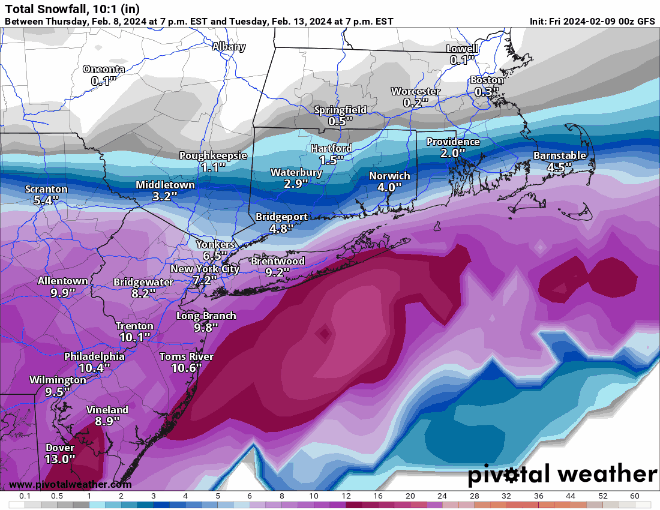
If the 6Z GFS is correct for Trenton to NYC along 95, for example (and we have no clue), it's showing 7-8" of 10:1 snow falling from the sky from 10 am to 4 pm with good looking DGZ snow crystal formation/growth, column temps well below 32F until very close to the surface and surface temps around 33F. Verbatim, that snow is ;likely going to accumulate easily at over 1" per hour rates and will likely do better than the Kuchera algorithm, which treats a 1500 foot deep 33F layer aloft the same as it does a shallow 300 foot 33F layer right at the surface (it only takes max column temp into consideration, not depth=time at that max temp) and those aren't the same, as less partial melting will occur in the latter case, meaning less compaction and loss of good ratios. If the GFS is correct. Interestingly, the GEFS shows warmer surface temps of 35-37F during the event, but since it's showing a smoothed mean of many members, the ~6" of snow it shows falls over 9-12 hours, so at maybe 0.5" per hour, which is not nearly as dynamic and that could be why there is less cooling at the surface; at those temps during the day and at lower intensity, though, one would expect a fair amount less snow to accumulate. One would think the Op is more likely to show dynamics better than the ensemble mean, though. Intensity is going to be so important for this storm if the GFS is close to right, especially during the day... -
2/13 Significant/Major Winter Storm Discussion & Observations
RU848789 replied to Northof78's topic in New York City Metro
Interesting that the GEFS mean max snow moved south with the 95 corridor being along that max for the most part (and is now fairly similar to the EPS mean), while the GFS Op max snowfall axis moved considerably north (losing a lot of snow for SNJ/SEPA). NYC looking to be set up nicely. Don't love that the GEFS surface temps never go below 35-36F from Trenton to NYC though (the GFS does get down to 32-33F as does the EPS), which will certainly cut down on accumulations some, verbatim (although with most of the snow falling at ~1"/hr rates, the snow will accumulate).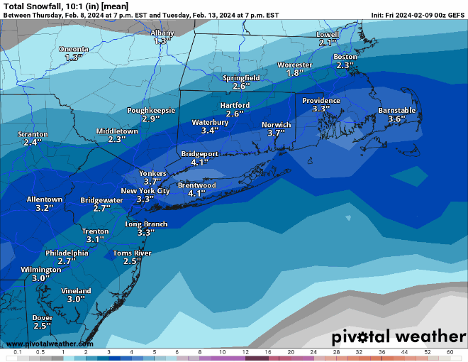
-
2/13 Significant/Major Winter Storm Discussion & Observations
RU848789 replied to Northof78's topic in New York City Metro
Euro looking similar to the GFS in many ways, although it's a little earlier and not as snowy - but a big improvement over 12Z, especially for those along 78 and even 95. The early part would help with accumulations as ~90% of the snow falls before 7 am (after a good 3/4" of rain, at least for 95). Euro and GFS vs. CMC and UK, I guess. -
2/13 Significant/Major Winter Storm Discussion & Observations
RU848789 replied to Northof78's topic in New York City Metro
What is wrong with you people? Just kidding, but normally, when I'm away from the internet (poker night) for many hours during the run-up to an event, I judge whether things went well in the model suite by how many new pages there are in the thread and there was only one new page, so I assumed the GFS and CMC were both terrible, but then I check and the GFS looks great while the CMC was just way south with most of the precip, much earlier. So at least it's not all bad - neither model really budged much I guess from previous runs. -
2/13 Significant/Major Winter Storm Discussion & Observations
RU848789 replied to Northof78's topic in New York City Metro
The fall line is the 95 corridor for the purposes of weather along the eastern seaboard and especially from DC to Boston. More formally it's where the coastal plain meets the Piedmont and just NW of the fall line is where elevations start to increase and the fall line is often along rivers, like the Delaware in SNJ/SEPA. https://en.wikipedia.org/wiki/Atlantic_Seaboard_Fall_Line -
2/13 Significant/Major Winter Storm Discussion & Observations
RU848789 replied to Northof78's topic in New York City Metro
And Mt. Holly is much more optimistic than this morning, when they were only calling for a chance of snow well NW of 95; here's their latest...I like the part in bold... LONG TERM /SUNDAY NIGHT THROUGH THURSDAY/... Unsettled weather on tap for the start of the new work week as a developing storm system impacts the Northeast and Mid- Atlantic. However, there are numerous inconsistencies among the models that leads to a low confidence forecast. A deep upper trough over the West Coast ejects into the southern Plains, and the base of the trough pinches off into a closed upper low over the Southern Plains and Gulf Coast states Sunday night. Surface low pressure develops out ahead of it and moves towards the Mid-Atlantic on Monday. This is where the models go awry. The 12Z/08 ECMWF has the low passing through southern New Jersey and Delmarva Monday night, and then the low intensifies off the New Jersey coast as the H5 trough follows behind it Tuesday morning. This system then departs Tuesday afternoon. In terms of sensible weather, the predominant ptype will be rain on Monday, changing to snow over the southern Poconos and northern New Jersey Monday night and Tuesday as colder air filters into the region behind the departing low. A plowable snow is possible for those areas, and possibly even down to the Fall Line. The surface low is faster in the 12Z/08 CMC, with rain moving into the region earlier on Monday, and has the low over eastern Long Island by Tuesday morning. The storm is then gone Tuesday afternoon before the cold air filters into the region. This results in minimal snow accumulation. The outlier, though it has been a consistent outlier, is the 12Z/08 GFS. The storm is much slower, with the low still over North Carolina and Virginia Tuesday morning, and then passes through Delmarva during the day Tuesday before departing Tuesday night. With high pressure building in from the north, cold air advection will be underway, and temperatures drop to below freezing across much of the region. This results in at least a plowable snow across much of southern New Jersey and into Delmarva. The NBM snow probabilities have a less than 10 percent chance for 4 inches of snow or more in 24 hours ending at 00Z Wednesday for most areas south of the Fall Line, and up to 25 percent chance for 4 inches of snow or more in the 24 hours ending at 00Z Wednesday for the southern Poconos and northern New Jersey. Due to the low confidence in the forecast, opted to follow the NBM guidance closely. This results in likely PoPs for Monday afternoon and Monday night, and chance PoPs for Tuesday morning. Opted to keep slight chance PoPs continuing into Tuesday afternoon, mainly due to the GFS being slower. -
Walt - the NBM, which I know you and the NWS favor, is finally showing at least a minor snowfall for NYC Metro (1-3"); granted it's hard to know how much of this would truly accumulate, but if we see anything like the rates the GFS is showing, it won't matter much, whereas if we only get light to moderate rates during the day, it's white rain. Too early to know those details.
-
Zoomed in, just for our forum, because snow, lol. Even though there isn't much model support from the other models for this. I'd be happy with 6" of snow over the next 15 days given how little snow we've had, so I guess we have to wait until we some other models come on board for something like this. It is pretty though.
-
Could the GFS and CMC be any more different? And yes, 10:1 is likely on the high end but at >1" per hour snowfall rates, melting should be minimal and snow growth should be excellent, so Kuchera probably underdoes ratios. Of course, if no snow falls like on the CMC ratios probably aren't that important, lol.
-
Remember, a big chunk of TT's "snow" is actually sleet being counted as 10:1 snow, as you can see from the Pivotal map for the same timeframe, where they only report snowfall, which is much less than for TT (sleet is omitted, which is its own separate problem, as that doesn't paint the whole frozen precip picture and the sleet mass is the same as the snow mass and almost as impactful).
-
Yep, although unfortunately, unlike the snowier solutions a few runs ago, this one has all of the snow for NYC Metro/95 falling from 10 to 4 pm on 2/13, meaning with surface temps around 34-35F at midday, accumulations will be very difficult unless we see fairly heavy intensity. I'd still way rather see white rain than real rain, though.
-
Walt - think you might have accidentally replied to my post on chemical incidents, which was spurred by your excellent post on NTSB incidents. Also, tried to send you an IM, but the site says you can't receive IMs - was wondering if that's just something you had set up or not activated. Nothing earth shattering - just a question or two on the weather.
-
Today's rainstorms for 95% of this subforum from the 12Z GFS and CMC are what I was afraid of and reasons why not to start a thread yet. Nobody is saying there's no chance of snow for NYC metro/95/coast, but we'd need to see a lot more consensus snow in multiple model cycles to have any such confidence and we're nowhere near that now.
-
Same with OSHA chemical incident investigations/reports (they're similar to the NTSB reports conceptually), which was my field when I was working at Merck, having been the director of the group responsible for chemical process safety testing and evaluations for new processes progressing through R&D and eventually going to manufacturing sites (if a new drug was successful). After action reviews, done well, can be eye opening to pre-incident errors in systems, judgment and analysis, often revealing biases and lack of attention to detail from key actors in these incidents and we used them liberally as teaching tools in trying to ensure that our staffs doing the testing and evaluations weren't subject to bias and/or overlooking key factors. We didn't have any significant incidents during that time, fortunately.
-
I wouldn't start a thread either, as we're still pretty far out and even the "snowy" models have significant thermal issues that would likely significantly reduce accumulation, plus we've only really had one model suite (last night) with just about every model showing at least moderate accumulating snow (at 10:1 ratios). I'd want to see at least some consistency for another cycle or two, i.e., maybe after tonight's 0Z runs, which would put us about 5 days before the event is likely to start. Just my opinion and I'd absolutely defer to Walt on this.
-
Yes, but not for 24+ hours
-
Yeah, I'm 61 and still love the cold and snow and don't imagine that ever changing. I'm retired and am outside for several hours per day at least 5 days a week between disc golf, soccer, and doing little day trips with my wife. Obviously, someday I'll be less mobile, but until then I love getting outdoors.
-
That's irrelevant with temps in the mid-30s Monday morning and highs in the mid-40s on Monday and then temps down into the upper 30s before any precip starts Monday night. Yes, ground will be above 32F, but not far above 32F.
-
I'm astounded by how much snow/precip falls in such a short period on the 6Z GFS, with 2/3 of the snow for NYC metro falling from 4 to 7 am on 2/13 (night time is great for this marginal run), which is 6" or more for most in that 3-hour period and most of the rest falls in the next 3 hours. If we end up with a storm like this, we're talking knife's edge for any forecast, given surface temps, verbatim, for folks along 95 never go below 34F (so ratios likely are low, although the whole column is below 32F except for very near the surface and at high rates ratios might not be as bad as shown by Kuchera). Anyway, I know discussing thermal details at this point is a bit silly - it's just wild to see what is possible with this event, IMO...
-
And just to whet people's appetites for the long range tracking marathon...
-
Euro is heavy rain to heavy snow for most. Still 6+ days out, but the Euro/UK/GFS/CMC all show at least moderate snowfall for NYC Metro with less to the S/SW and of course if this continues to look good we'll eventually be worrying about how much rain/mix before the snow and ratios and melting and everything else, but the take home message is we actually have a decent shot at some snow.
-
Nice, but still a week away...
-
Nice to see a signal for a potential winter storm.


