RU848789
-
Posts
4,002 -
Joined
-
Last visited
Content Type
Profiles
Blogs
Forums
American Weather
Media Demo
Store
Gallery
Everything posted by RU848789
-
Refresher snow & obs between ~midnight and Noon Sat Feb 17 2024
RU848789 replied to wdrag's topic in New York City Metro
So somehow in what has been a crappy winter for many we've overperformed on almost every storm... the 11.25" yesterday brings me to 24.5" for the season which is actually ahead of normal for this date. It's just nuts that we're 17" ahead of CPK, just 25 miles to our NE. I'll take it and run lol. -
Refresher snow & obs between ~midnight and Noon Sat Feb 17 2024
RU848789 replied to wdrag's topic in New York City Metro
Snow ratio time. I thought it was 15-20:1, but we actually got 22:1 - damn! Got 11798 cc of snow melted down to just 530 cc of liquid, so the 11.25" was only 0.5" QPF. -
Refresher snow & obs between ~midnight and Noon Sat Feb 17 2024
RU848789 replied to wdrag's topic in New York City Metro
I used a broom but over 3 clearings through the night. -
Refresher snow & obs between ~midnight and Noon Sat Feb 17 2024
RU848789 replied to wdrag's topic in New York City Metro
Not sure if posted yet... what a gradient.. from 12" in Bridgewater to 4" in Bernard's over 6 miles... -
Refresher snow & obs between ~midnight and Noon Sat Feb 17 2024
RU848789 replied to wdrag's topic in New York City Metro
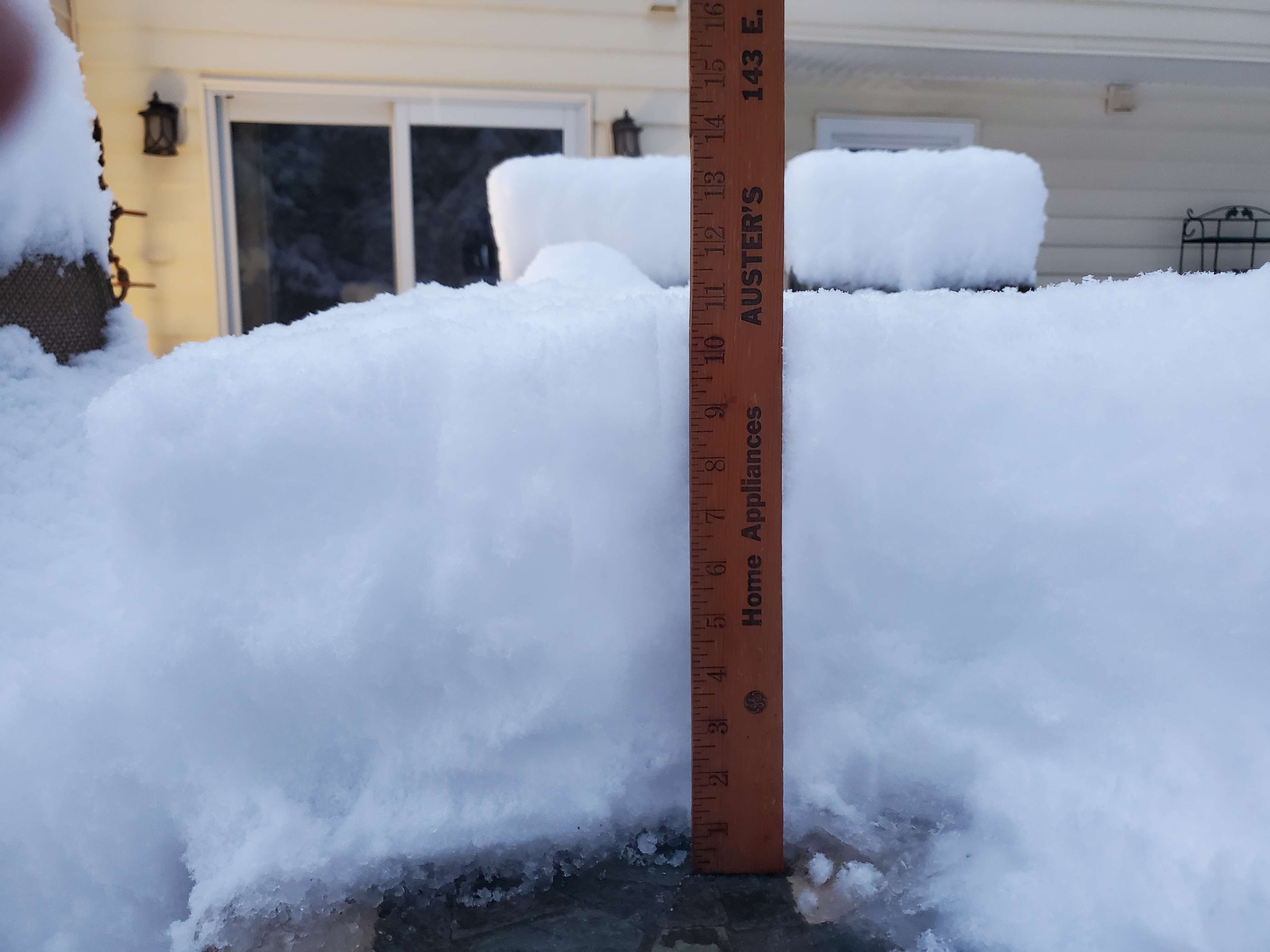
I did wake up for a few around 9.30 am and we had about another 1/4" that had fallen sometime after 8 am, so my final total is 11.25"... also saw that someone else in Metuchen has reported 10.9" around 7 am when I had 11" and plenty of 10-12" reports from NB, edison, etc. I'm pretty sure this is the biggest positive bust I can remember, at least in my 31 years in Metuchen. Jan 1987 is probably the other biggest +bust I can recall or maybe Feb 83. I will have snow ratio data in a few hours (melting takes awhile).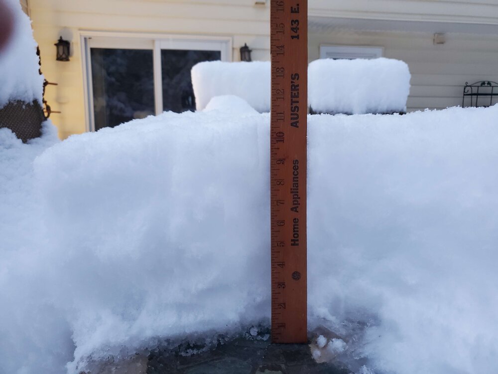
-
Refresher snow & obs between ~midnight and Noon Sat Feb 17 2024
RU848789 replied to wdrag's topic in New York City Metro
Here's a pic of my semi-final measurement (one more moderate band coming thru)
-
Refresher snow & obs between ~midnight and Noon Sat Feb 17 2024
RU848789 replied to wdrag's topic in New York City Metro
As of about 5.50 am the snow band finally petered out and I measured 11.0" for a paltry 1" in the last hour - usually i would kill fire that lol. Could still get another inch over the next few hours but the main event is over. Saw 12" retorted in Readington and plenty of 10+" amounts in CNJ and 9.9" in Metuchen at 5 am which is very close to my 10" at 4.45 am. Really feeling like a once in a lifetime event for a surprise localized major storm and especially getting 2"/hr rates for 5+ hours. Very LES like. -
Refresher snow & obs between ~midnight and Noon Sat Feb 17 2024
RU848789 replied to wdrag's topic in New York City Metro
As of 4.45 am we just hit 10"! So 1.75" last hour. Must be at least 15.1 ratio snow... looks like another 30-45 min of heavy snow... -
Refresher snow & obs between ~midnight and Noon Sat Feb 17 2024
RU848789 replied to wdrag's topic in New York City Metro
8.25" as of 3.45 am so 2"/hr last 30 min... this is just nuts! -
Refresher snow & obs between ~midnight and Noon Sat Feb 17 2024
RU848789 replied to wdrag's topic in New York City Metro
As of 2.45 am we had 6.5" otg so then I shoveled because gorgeous and now as of 3.15 am we have 7.25" so "only" 1.75" last hour... looking at the radar I think 10" is possible. -
Refresher snow & obs between ~midnight and Noon Sat Feb 17 2024
RU848789 replied to wdrag's topic in New York City Metro
As of 2.15, 5.5" otg so 3"/hr rate last 30 minutes. This is a once in 10 year deformation snow band. It's insanely gorgeous out there... this is almost like lake effect snow. NWS just put out a warning for Middlesex for 4-6" more snow after 2 am and for Somerset, Mercer and Hunterdon for 3-5" more snow after 2 am. That means we could hit 10" here. This reminds me of that incredible inverted trough band of 10" they got at an Eagles game several years ago. -
Refresher snow & obs between ~midnight and Noon Sat Feb 17 2024
RU848789 replied to wdrag's topic in New York City Metro
Unreal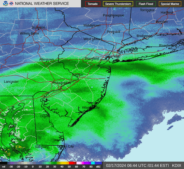
-
Refresher snow & obs between ~midnight and Noon Sat Feb 17 2024
RU848789 replied to wdrag's topic in New York City Metro
4" otg as of 1.45 pm so we're at 4"/hr rates the last 30 min which is close to the most I've ever seen. If this somehow keeps up even at "just" 1-2"/hr for a few hours we'll get 8" or more! -
Refresher snow & obs between ~midnight and Noon Sat Feb 17 2024
RU848789 replied to wdrag's topic in New York City Metro
Holy crap! Dozed off at midnight with light snow having just started and woke up at 1 am to deathband snow! We havre 2" otg as of 1.15 am which is incredible! Spectacular huge debrief dendrites... ratios must be at least 15.1. 30F. https://cdn.discordapp.com/attachments/1207471347551309864/1208299075137577001/20240217_011043.mp4?ex=65e2c734&is=65d05234&hm=20993d2259528f5e31cb9b7bddfd3729eee38db3ae2999993a43508d090c836d& -
Refresher snow & obs between ~midnight and Noon Sat Feb 17 2024
RU848789 replied to wdrag's topic in New York City Metro
Well there's this map so clearly mt holly has a mask... they just are late in posting it... union County ftw! (6 miles N of me lol)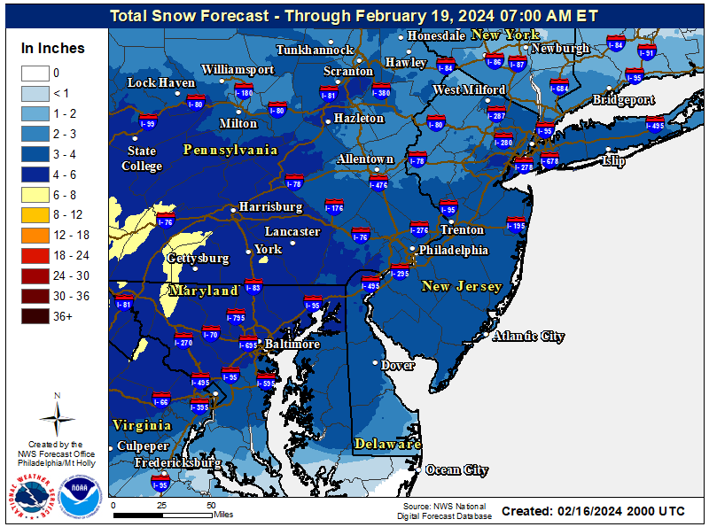

-
Refresher snow & obs between ~midnight and Noon Sat Feb 17 2024
RU848789 replied to wdrag's topic in New York City Metro
Updated map of warnings and advisories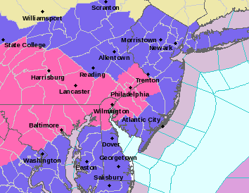
-
Refresher snow & obs between ~midnight and Noon Sat Feb 17 2024
RU848789 replied to wdrag's topic in New York City Metro
Has anyone seen an updated mt holly map yet? -
Refresher snow & obs between ~midnight and Noon Sat Feb 17 2024
RU848789 replied to wdrag's topic in New York City Metro
Nice...
-
Refresher snow & obs between ~midnight and Noon Sat Feb 17 2024
RU848789 replied to wdrag's topic in New York City Metro
NBM keeps trending upwards...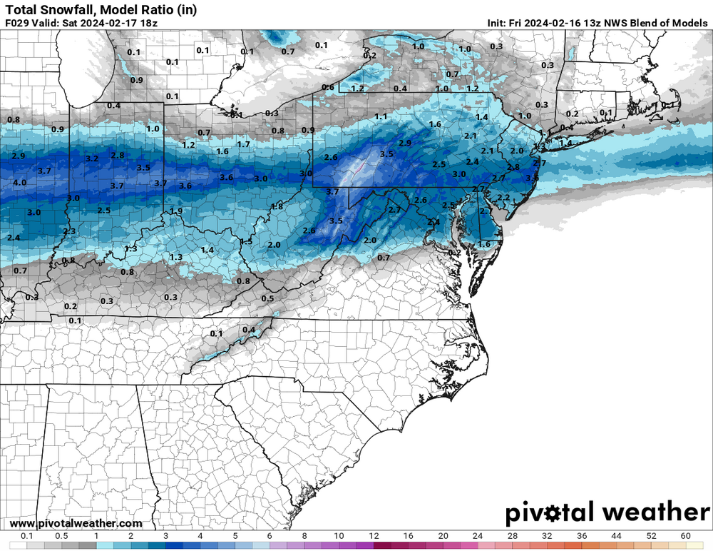
-
Refresher snow & obs between ~midnight and Noon Sat Feb 17 2024
RU848789 replied to wdrag's topic in New York City Metro
Lee Goldberg occasionally cites the RAP... -
Refresher snow & obs between ~midnight and Noon Sat Feb 17 2024
RU848789 replied to wdrag's topic in New York City Metro
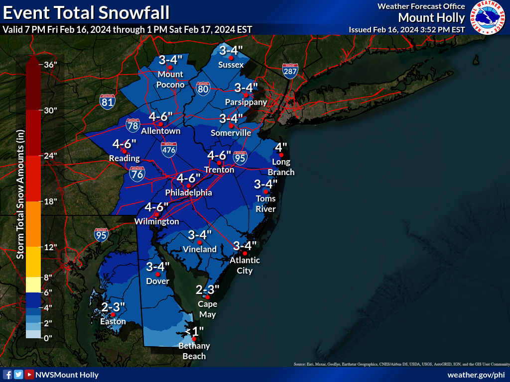
NWS regional snowfall forecast. NWS also noted that 2-3" amounts might easily extend north to include the rest of NNJ, NENJ, NYC, and LI. -
Refresher snow & obs between ~midnight and Noon Sat Feb 17 2024
RU848789 replied to wdrag's topic in New York City Metro
Based on one NAM run that's a little dry? I'll take the RGEM and CMC over the NAM/GFS (showing it's SE bias again) any day. Also, let's see how the rest of the model suite plays out. If the Euro/UK trend drier, then the concern is likely warranted, but if they hold serve, it's time to be a bit more confident in a 1-3" snowfall. Ratios might also be >10:1, but not convinced about that without better omega (cold isn't everything). -
Refresher snow & obs between ~midnight and Noon Sat Feb 17 2024
RU848789 replied to wdrag's topic in New York City Metro
NWS-Philly updated their snowfall map While it's a fairly minor event, assuming we get 1-2" (3" would be nice), it will be impactful on Saturday morning travel, as every flake will accumulate with below 32F temperatures during the event, which will be from around 1 am through 10 am. Roads should be fine by late morning as precip stops and we get more indirect sunlight and temps go above 32F for most, except for far NW locations. -
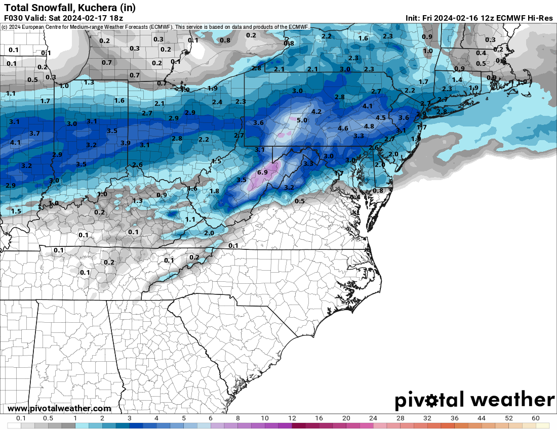
Good point on elevation as it's always important, but I think the main reason areas 10-20 miles and more NW of 95 got a lot more snow with this system was that precip amounts were much greater not that they were at elevation; much of the 95 corridor from Trenton to NYC got stuck in a subsidence zone for 2-3 hours with much less snow falling, as per the radar in real time and the graphic below shows the stark difference of 0.4-0.6" QPF falling from 1 am to 1 pm (precip was over for everyone by then) for the whole 95 corridor from CNJ through NYC vs. 0.8-1.2" QPF for most of NEPA, NWNJ and the Hudson Valley. And this difference was even worse from 8:30-11:30 am, which was the prime time for heavy snow and we got only 1.5" during that time, which was less than we got during the one hour from 7:30-8:30 am (1.75" of snow) - I easily would've had 9-10" instead of 6" if I had gotten the precip amounts those NW of me got and I think the same is true for much of the 95 corridor locations from CNJ through NYC/NENJ - we would've kept snowing heavily and accumulating, if only we got the precip, but we didn't. Where elevation and temp certainly played a difference was the timing of the changeover to snow, as it was colder, earlier, further NW (not unusual in these setups). We lost a few tenths of precip to rain before changing at 4:30 am, whereas areas well NW, changed 2-3 hours earlier, getting probably 1-2" more during that time (precip wasn't as heavy). Also if it was just elevation playing a role, then why did so many locations SE of the fall line (I'm about 8-9 miles SE of it) even get 5-7", as in Middlesex/Somerset counties? As an aside, lack of precip intensity is almost certainly why areas from Philly SE through SNJ got very little snow (an inch or so near Philly and little to no snow SE of there. The precip wasn't heavy enough early on to dynamically cool the column (plus they changed oer to snow even a few hours later than we did) and then by mid-morning, when temps were finally cooler, the precip still wasn't heavy enough.
-
NWS first map, but only through 7 am Sat and while it looks like the precip is 80-90% over by then, it's not done yet on some of the models - don't know why they can't just do these through the end of the storm.