MN Transplant
-
Posts
17,493 -
Joined
-
Last visited
Content Type
Profiles
Blogs
Forums
American Weather
Media Demo
Store
Gallery
Everything posted by MN Transplant
-
Summer max contest -- final results posted
MN Transplant replied to Roger Smith's topic in Mid Atlantic
Since DCA moved to the current location, they are averaging about one 100-degree day per year. However, since 100-degree days are clustered, over the period of record, only about 1/3 of years have had a 100-degree day. This has held over the past two decades, with 7 years of 21 reaching 100 degrees. It has not hit 100 at DCA since August 2016. -
This is an oddball stat, but I looked it up because the difference between Friday (high 99) and Saturday (high 79) was so stark. At DCA (since 1941), there have only been 9 summer days with temperature drops of more than 20 degrees between consecutive days. Several of those included precip, which means that there have only been a handful of periods similar to what we just encountered.
-
I know it isn’t pool weather, but considering temperature, time of year, lack of bugs (early season plus wind), full vegetation, it really is an all-time type of day out there. Just awesome to sit in the backyard.
-
I’m guessing there aren’t many midnight highs in the 2nd half of June. Pretty good chance tomorrow.
-
2022 Mid-Atlantic Severe Wx Thread (General Discussion Etc)
MN Transplant replied to Kmlwx's topic in Mid Atlantic
The big problem here is that we have a ton of densely-treed neighborhoods. It doesn't even take a severe-level storm to cause damage, especially to old and dying trees. So, we may scoff at some of the warnings, but I bet a lot of them are verifying via damage reports. -
The reason I mentioned the records this morning was that the conditions were perfect to overperform, especially at DCA. Dry, mid-day frontal passage with downslope winds? Torch.
-
New record high at DCA. At least 98. Winds are really kicking up.
-
My kid is at tennis/swim camp at the local pool. We packed a lot of ice with her today. Hopefully the extend the pool time. Per IADASOS, Dulles is already to 93, breaking the daily record before noon.
-
Already got 90 at home.
-
Can’t complain about lows on a day where we may set (shatter for IAD) record highs. 97 DCA 96 BWI 92 IAD
-
2022 Mid-Atlantic Severe Wx Thread (General Discussion Etc)
MN Transplant replied to Kmlwx's topic in Mid Atlantic
Those can be dangerous since people aren’t expecting them. -
2022 Mid-Atlantic Severe Wx Thread (General Discussion Etc)
MN Transplant replied to Kmlwx's topic in Mid Atlantic
I wasn’t paying much attention today but was optimistic based on the radar a while back. Then I saw this. Sure enough, completely dying as it moves east. -
You torched. 89 at DCA/BWI, 88 at IAD/my house.
-
2022 Mid-Atlantic Severe Wx Thread (General Discussion Etc)
MN Transplant replied to Kmlwx's topic in Mid Atlantic
Yeah, we are looking at Chicago and north. edit - speaking of which, damn! -
That sounds like a station that does not have good ventilation. Given the 92 at IAD, the 91 at Manassas, and a 92 at one of the other Haymarket PWSs, I think 92 is a good number for today.
-
2022 Mid-Atlantic Severe Wx Thread (General Discussion Etc)
MN Transplant replied to Kmlwx's topic in Mid Atlantic
That is a beauty of a supercell in southern WI right now.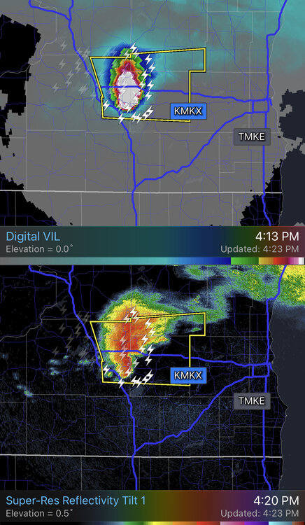
-
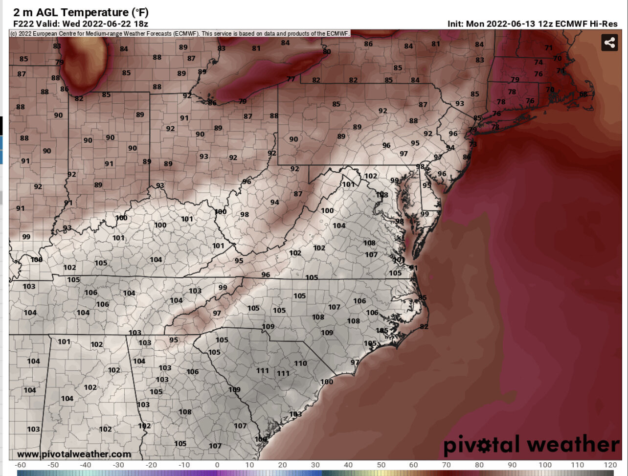
The 00z Euro had temps on Wednesday (2 days away) near 100 around here. The 12z run is in the upper 80s. It is struggling.
-
Somebody broke the Euro

-
2022 Mid-Atlantic Severe Wx Thread (General Discussion Etc)
MN Transplant replied to Kmlwx's topic in Mid Atlantic
If you continue the loop on the NAM Nest it has a westward moving squall line through SC/GA. That would be wild. -
2022 Mid-Atlantic Severe Wx Thread (General Discussion Etc)
MN Transplant replied to Kmlwx's topic in Mid Atlantic
All of the models except the NAM Nest fire an MCS Monday afternoon north of Chicago and keep it going to the east coast. NAM and GFS are north of us (NYC/Philly), but the Euro is right over us. -
Actually pulled off a midnight high.
-
2022 Mid-Atlantic Severe Wx Thread (General Discussion Etc)
MN Transplant replied to Kmlwx's topic in Mid Atlantic
Really, all the global have an MCS signature on Tuesday. Different timing. -
Yeah. Out on the course with a nice breeze. Near 80 and little humidity. Hard to ask for more this time of year.
-
.55 vs .43 actual here, but that’s still pretty good
-
I’ve had that happen to my station when the network cable connectors get wet.