binbisso
-
Posts
889 -
Joined
-
Last visited
Content Type
Profiles
Blogs
Forums
American Weather
Media Demo
Store
Gallery
Everything posted by binbisso
-
2/13 Significant/Major Winter Storm Discussion & Observations
binbisso replied to Northof78's topic in New York City Metro
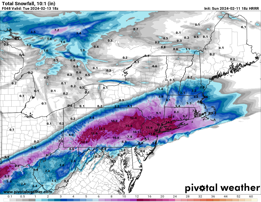
Nws forecast for Mt Vernon ny. Very bullish. Tuesday Rain and snow, becoming all snow after 7am. The snow could be heavy at times. High near 36. Wind chill values between 20 and 25. Breezy, with a northeast wind 16 to 22 mph becoming northwest in the afternoon. Chance of precipitation is 100%. New snow accumulation of 6 to 10 inches possible. -
2/13 Significant/Major Winter Storm Discussion & Observations
binbisso replied to Northof78's topic in New York City Metro
Winter Storm warnings up for all of Westchester. Watches for the city and LI -
2/13 Significant/Major Winter Storm Discussion & Observations
binbisso replied to Northof78's topic in New York City Metro
I think the red flag is the national weather service high-end and low end probabilities this morning. For White Plains it had 9 inches as the high-end and 0 as the low end. That's a pretty big difference this close in. The answer probably lies somewhere in between but it can definitely go either way. -
2/13 Significant/Major Winter Storm Discussion & Observations
binbisso replied to Northof78's topic in New York City Metro
Nws point and click for southern Westchester is 1-3" for Mt Vernon, 2-4 for Eastchester and 3-7" for purchase. So a low of one inch to a high of 7 inches in a 10 mile area. -
2/13 Significant/Major Winter Storm Discussion & Observations
binbisso replied to Northof78's topic in New York City Metro
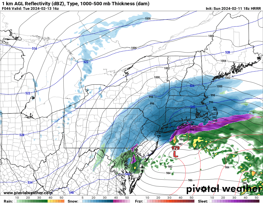
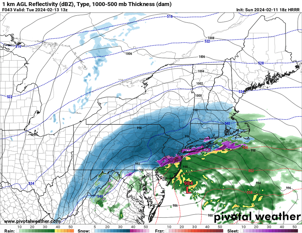
Lr hrrr is well south
-
2/13 Significant/Major Winter Storm Discussion & Observations
binbisso replied to Northof78's topic in New York City Metro
We will need a strong system with heavy precipitation and good dynamics For it to accumulate. The nam/rgem solutions will not do it -
2/13 Significant/Major Winter Storm Discussion & Observations
binbisso replied to Northof78's topic in New York City Metro
A big red flag that the nam and rgem are not juiced up. -
Let the 6z gfs Verify please. Then we can end winter
-
If next week's system comes on Monday it's rain. If it is delayed to late Tuesday we have a better chance as colder air begins to filter in. Ensembles differ on timing right now. We watch
-
I'm a little confused. We never had measurable snow in late january with a positive ao and a positive n a o
-
Yup not one model showed it. snowing lightly here. I think Walt Mentioned it in his write up that today's light snow could saturate the column which could help with tomorrow's event.
-
2" snow depth at lga, jfk and Newark as of 7am
-
Two Mdt to high impact events NYC subforum; wknd Jan 6-7 Incl OBS, and mid week Jan 9-10 (incl OBS). Total water equiv by 00z/11 general 2", possibly 6" includes snow-ice mainly interior. RVR flood potential increases Jan 10 and beyond. Damaging wind.
binbisso replied to wdrag's topic in New York City Metro
Yup. If there Wasn't that sneaky warm layer last evening Probably would have gotten 3 Inches. -
Two Mdt to high impact events NYC subforum; wknd Jan 6-7 Incl OBS, and mid week Jan 9-10 (incl OBS). Total water equiv by 00z/11 general 2", possibly 6" includes snow-ice mainly interior. RVR flood potential increases Jan 10 and beyond. Damaging wind.
binbisso replied to wdrag's topic in New York City Metro
Heavy snow now everything covered- 3,610 replies
-
- 1
-

-
- snow
- heavy rain
- (and 5 more)
-
Two Mdt to high impact events NYC subforum; wknd Jan 6-7 Incl OBS, and mid week Jan 9-10 (incl OBS). Total water equiv by 00z/11 general 2", possibly 6" includes snow-ice mainly interior. RVR flood potential increases Jan 10 and beyond. Damaging wind.
binbisso replied to wdrag's topic in New York City Metro
Fell sleep at 8 o'clock last night with the rain woke up at midnight with .6 inches of snow. It must have flipped some time between then. Snowing lightly now 32°. -
Two Mdt to high impact events NYC subforum; wknd Jan 6-7 Incl OBS, and mid week Jan 9-10 (incl OBS). Total water equiv by 00z/11 general 2", possibly 6" includes snow-ice mainly interior. RVR flood potential increases Jan 10 and beyond. Damaging wind.
binbisso replied to wdrag's topic in New York City Metro
Me neither. When it's snowing in places like New Brunswick Edison Manhattan Long Island its usually snow here.I've been here 26 years and never experience this yet.- 3,610 replies
-
- 1
-
-
- snow
- heavy rain
- (and 5 more)
-
Two Mdt to high impact events NYC subforum; wknd Jan 6-7 Incl OBS, and mid week Jan 9-10 (incl OBS). Total water equiv by 00z/11 general 2", possibly 6" includes snow-ice mainly interior. RVR flood potential increases Jan 10 and beyond. Damaging wind.
binbisso replied to wdrag's topic in New York City Metro
That's amazing you're about 5 miles to my North. -
Two Mdt to high impact events NYC subforum; wknd Jan 6-7 Incl OBS, and mid week Jan 9-10 (incl OBS). Total water equiv by 00z/11 general 2", possibly 6" includes snow-ice mainly interior. RVR flood potential increases Jan 10 and beyond. Damaging wind.
binbisso replied to wdrag's topic in New York City Metro
Lights snow started about 330 here. around 4 o'clock switch to rain. It's about 75% to 25% rain to snow since then. I'm in Southern Westchester this makes no sense. -
Two Mdt to high impact events NYC subforum; wknd Jan 6-7 Incl OBS, and mid week Jan 9-10 (incl OBS). Total water equiv by 00z/11 general 2", possibly 6" includes snow-ice mainly interior. RVR flood potential increases Jan 10 and beyond. Damaging wind.
binbisso replied to wdrag's topic in New York City Metro
Definitely some flakes mixing in but it's mostly rain here. -
Two Mdt to high impact events NYC subforum; wknd Jan 6-7 Incl OBS, and mid week Jan 9-10 (incl OBS). Total water equiv by 00z/11 general 2", possibly 6" includes snow-ice mainly interior. RVR flood potential increases Jan 10 and beyond. Damaging wind.
binbisso replied to wdrag's topic in New York City Metro
I'm having a hard time to figure this one out but I'm raining here in Mount Vernon.- 3,610 replies
-
- 1
-

-
- snow
- heavy rain
- (and 5 more)
-
Two Mdt to high impact events NYC subforum; wknd Jan 6-7 Incl OBS, and mid week Jan 9-10 (incl OBS). Total water equiv by 00z/11 general 2", possibly 6" includes snow-ice mainly interior. RVR flood potential increases Jan 10 and beyond. Damaging wind.
binbisso replied to wdrag's topic in New York City Metro
Park is down to 34 with heavy snow. -
Two Mdt to high impact events NYC subforum; wknd Jan 6-7 Incl OBS, and mid week Jan 9-10 (incl OBS). Total water equiv by 00z/11 general 2", possibly 6" includes snow-ice mainly interior. RVR flood potential increases Jan 10 and beyond. Damaging wind.
binbisso replied to wdrag's topic in New York City Metro
snow has just started in Mount Vernon. -
Two Mdt to high impact events NYC subforum; wknd Jan 6-7 Incl OBS, and mid week Jan 9-10 (incl OBS). Total water equiv by 00z/11 general 2", possibly 6" includes snow-ice mainly interior. RVR flood potential increases Jan 10 and beyond. Damaging wind.
binbisso replied to wdrag's topic in New York City Metro
Precipitation is definitely coming in faster than modeled. that was one of Upton's concerns regarding snowfall amounts for coastal areas -
Two Mdt to high impact events NYC subforum; wknd Jan 6-7 Incl OBS, and mid week Jan 9-10 (incl OBS). Total water equiv by 00z/11 general 2", possibly 6" includes snow-ice mainly interior. RVR flood potential increases Jan 10 and beyond. Damaging wind.
binbisso replied to wdrag's topic in New York City Metro
I saw pictures from a friend's house in Flemington new Jersey moderate snow sticking on all surfaces. That bode's well for the park and areas North.