binbisso
-
Posts
889 -
Joined
-
Last visited
Content Type
Profiles
Blogs
Forums
American Weather
Media Demo
Store
Gallery
Everything posted by binbisso
-
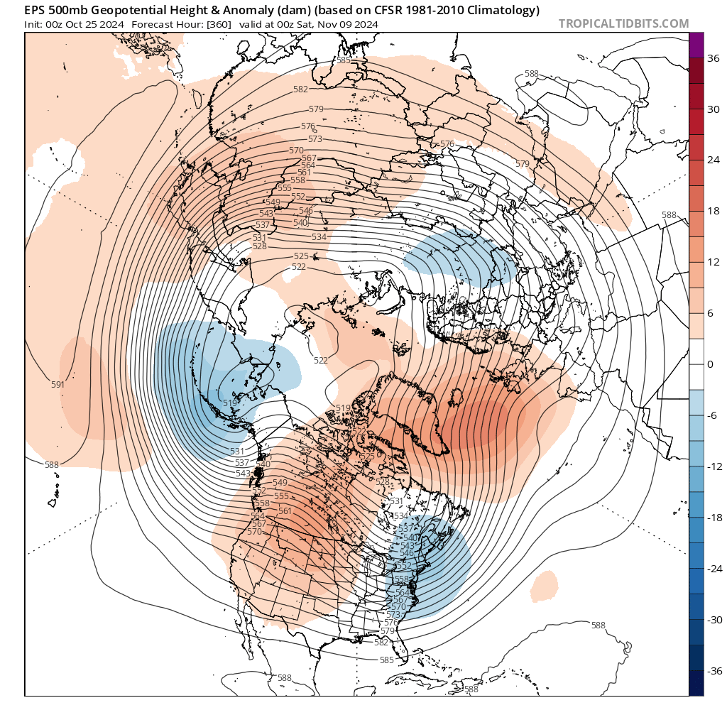
@ brooklynwx99 not saying you are calling for a very warm November but many others have
-
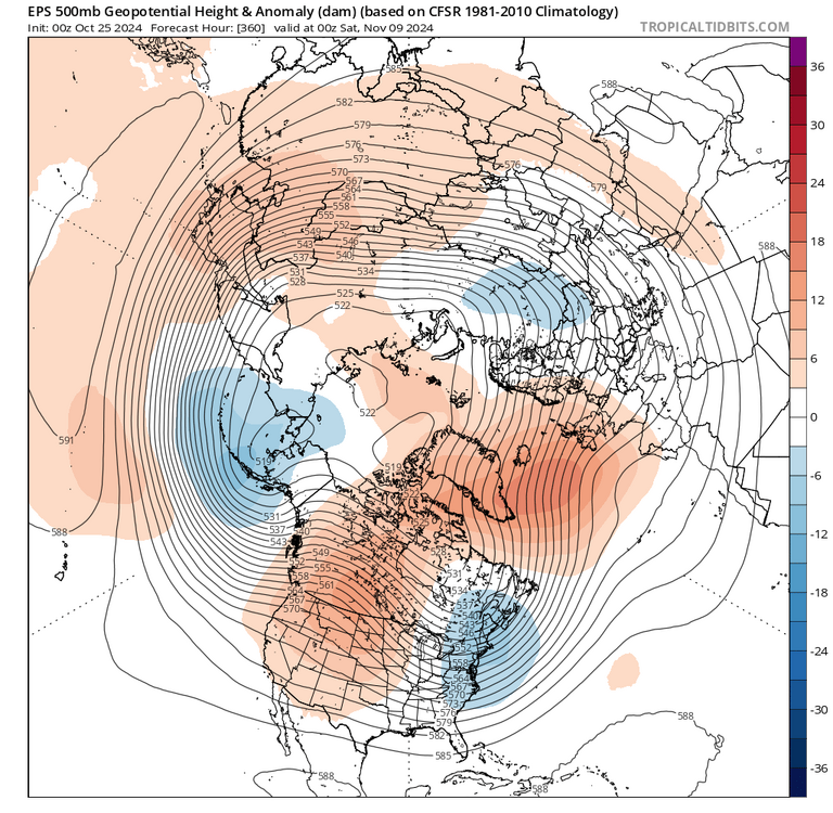
I'm a little skeptical of the very warm to historic warm November at least here in the east. The first 3 days look very warm however the operational and ensembles are now showing a ridge out west and a trough in the east thru the 10th. We look to go neutral nao/ao and +pna and possibly 8 thru 3 mjo. Maybe the second half torches but I'm not seeing that for the first half of November att
-
It would be nice if the next mjo wave starts mid November in phase 4 and makes it to 8 and 1 by early-mid December.
-
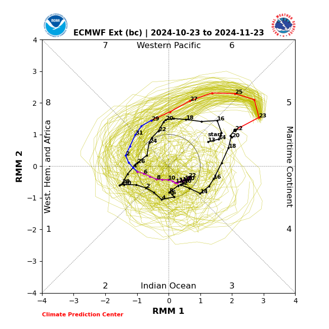
Will be interesting to see if this wave can go 8 thru 3. Hasn't really happened in late fall and winter the last few years. Euro says no 2nd image. Gfs 1st image
-
Hmm looks like a nino pattern after the first few days of November. Mjo 8 thru 2? I wonder if this will verify.
-
@bluewave you were monitoring the mjo in october for clues about this coming winter. With October starting in phase 1 and ending in the COD mid month does this give you any hints regarding winter
-
Lga high is 89* with a dew point of 66*. South wind has kicked in and temperature is dropping. Very tolerable
-
There is no heat wave for the boroughs, long Island southern conn and westchester. That's about 70% of this sub forum. 1010 wins is right. It's somewhat uncomfortable out and well above normal but no heat wave
-
Lga is 85* dp 66. Top ten summer day.
-
2/13 Significant/Major Winter Storm Discussion & Observations
binbisso replied to Northof78's topic in New York City Metro
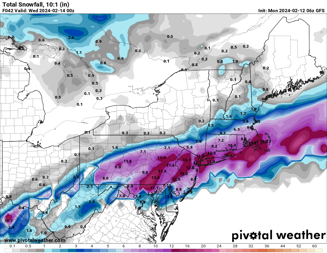
7.5" final. 11.5" for the season -
2/13 Significant/Major Winter Storm Discussion & Observations
binbisso replied to Northof78's topic in New York City Metro
7" here 11" for the season. Still snowing moderately -
2/13 Significant/Major Winter Storm Discussion & Observations
binbisso replied to Northof78's topic in New York City Metro
Yup still ripping here haven't gone out to measure but have to be at 6 inches.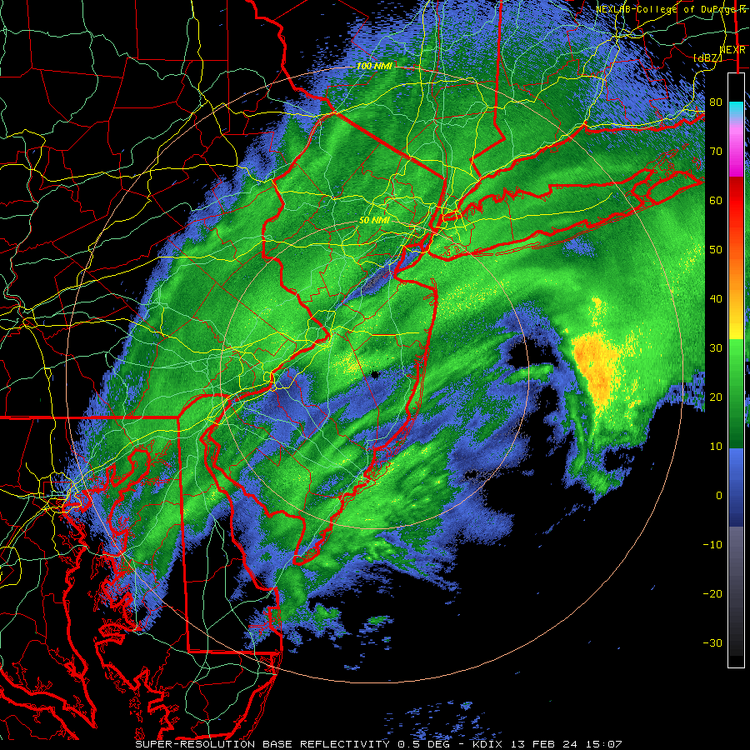
-
2/13 Significant/Major Winter Storm Discussion & Observations
binbisso replied to Northof78's topic in New York City Metro
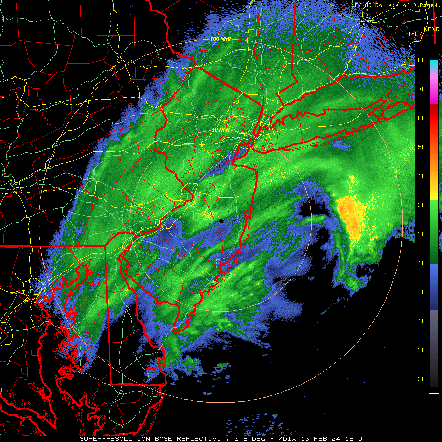
Manhattan is not in a dry slot Central Park has recorded .42 Le the last three hours With heavy snow. -
2/13 Significant/Major Winter Storm Discussion & Observations
binbisso replied to Northof78's topic in New York City Metro
The heavy band that was over Northwest new Jersey and the one South of Long Island are now converging over the nyc/wli Westchester county and Northeast new Jersey. -
2/13 Significant/Major Winter Storm Discussion & Observations
binbisso replied to Northof78's topic in New York City Metro
Cpk reported heavy snow the last 2 hours. .26 lqe. They should be close to 4" by now -
2/13 Significant/Major Winter Storm Discussion & Observations
binbisso replied to Northof78's topic in New York City Metro
Ripping snow here definitely going to exceed 6" here. -
2/13 Significant/Major Winter Storm Discussion & Observations
binbisso replied to Northof78's topic in New York City Metro
Heavy snow in Mt Vernon 4" on the grass. Tree branches sagging. Beautiful outside -
2/13 Significant/Major Winter Storm Discussion & Observations
binbisso replied to Northof78's topic in New York City Metro
Almost an inch on the grass and cars in the bronx. Still moderate snow with the good stuff yet to come -
2/13 Significant/Major Winter Storm Discussion & Observations
binbisso replied to Northof78's topic in New York City Metro
Moderate snow in the bronx starting to stick on everything -
2/13 Significant/Major Winter Storm Discussion & Observations
binbisso replied to Northof78's topic in New York City Metro
Snowing in the bronx. Not sticking yet -
2/13 Significant/Major Winter Storm Discussion & Observations
binbisso replied to Northof78's topic in New York City Metro
First flakes flying here in Mount Vernon no rain at ALL at the start. -
2/13 Significant/Major Winter Storm Discussion & Observations
binbisso replied to Northof78's topic in New York City Metro
Yup. I'm down to 39 dp 27. may Be all snow here -
2/13 Significant/Major Winter Storm Discussion & Observations
binbisso replied to Northof78's topic in New York City Metro
6z gfs crushes city. Another tic south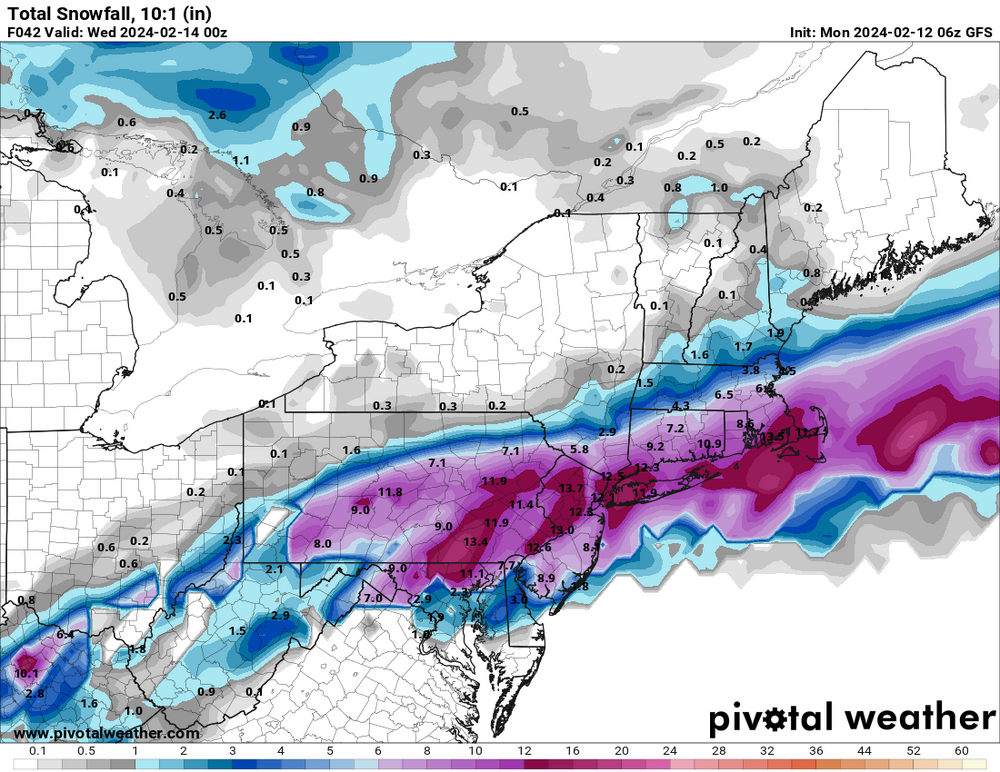
-
2/13 Significant/Major Winter Storm Discussion & Observations
binbisso replied to Northof78's topic in New York City Metro
Yup -
2/13 Significant/Major Winter Storm Discussion & Observations
binbisso replied to Northof78's topic in New York City Metro
All 3 nam held serve at 6z. Even upped totals