

binbisso
-
Posts
889 -
Joined
-
Last visited
Content Type
Profiles
Blogs
Forums
American Weather
Media Demo
Store
Gallery
Everything posted by binbisso
-
Obs and nowcast Super Bowl Sunday 4A-6P Feb 7, 2021
binbisso replied to wdrag's topic in New York City Metro
Snowing as hard as last week's storm except flakes are much bigger -
Obs and nowcast Super Bowl Sunday 4A-6P Feb 7, 2021
binbisso replied to wdrag's topic in New York City Metro
Me too. I think I'm in a great spot for this storm temp dropped to 29゚ last night snowing heavily with huge flakes now -
Obs and nowcast Super Bowl Sunday 4A-6P Feb 7, 2021
binbisso replied to wdrag's topic in New York City Metro
Heavy snow in Mount Vernon already a thick coating on the ground. Huge flakes -
What did the park measure at 1pm?
-
Same here. Just started ripping again. I'm your neighbor in Mt Vernon. Fantastic storm
-
11" inches here in Mt Vernon ny. Almost 3" the last hour
-
OBs and nowcast later Tuesday morning - Noon Wednesday 1/26-27
binbisso replied to wdrag's topic in New York City Metro
Light snow his started here in Mount Vernon 32゚ -
Snow-ice-rain for the NYC forum 7PM Mon 1/25-6AM Wednesday 1/27
binbisso replied to wdrag's topic in New York City Metro
Ukie also came in with more qpf. 2 to 4" on the snow maps. The trend on 12z models is greater waa snows -
Obs and nowcast Sun 9A Jan 3 - 6A Mon Jan 4 2021
binbisso replied to wdrag's topic in New York City Metro
Snowed for about 30 minutes with some sleet mixed in at the end a covering on the roofs cars and grass. -
January 2021 General Discussions & Observations Thread
binbisso replied to Stormlover74's topic in New York City Metro
What a bomb on the euro day9. With the block being advertised on the models we are now going to see some wild Solutions in the next week and Beyond Edit. Not really a bomb but a nice Miller B redeveloper south of Long Island Fun Times ahead -
January 2021 General Discussions & Observations Thread
binbisso replied to Stormlover74's topic in New York City Metro
Today's Canadian has the January 4th system sitting and spinning in the North Atlantic for 5 consecutive days right up to the end of the Run. The model is finally seeing the block and looks like this can set up something in the 10 to 12 day time frame with another short wave in the Gulf and that low sitting in the 50-50 region. The EPS also has something in that time frame. Today's Canadian definitely makes more sense compared to the GFS which has basically cutter after cutter into the block -
January 2021 General Discussions & Observations Thread
binbisso replied to Stormlover74's topic in New York City Metro
With the current setup In the Atlantic with the negative Nao and AO you do not want cold Arctic air as that would only suppress system. + 5 in Canada and plus two here in mid-January through mid-February would work just fine as the block would cause systems to go underneath us and it will be plenty cold enough to snow. I know you know this as you are a knowledgeable poster but you're warm bias interferes with rational judgment and your predictions end up wrong. -
December 2020 General Discussions & Observations Thread
binbisso replied to bluewave's topic in New York City Metro
Don is it then more likely that the vortex will just weaken and not split and if so would that be a more favorable outcome for us here since a split usually favors Eurasia -
December 2020 General Discussions & Observations Thread
binbisso replied to bluewave's topic in New York City Metro
And it gets better the further out it goes let's just hope it verifies -
With regards to the big phased system next week which is still 6 or 7 days out. We need either a later phase further east or better yet miss the phase with the southern stream and see if the northern stream can dive under us and form a Coastal low south of Long Island. That's probably our best chance at seeing snow here in the Northeast with this system
-
November 2020 General Discussions & Observations Thread
binbisso replied to Rtd208's topic in New York City Metro
Yeah most Mets and others keep saying that this Nina is coupled with the atmosphere but obviously that is not the case as we typically would have a colder than normal November and December. Last year we had a Nino but November and most of December played out like a nina. clearly something's up between enso and the atmosphere. if this map plays out That's a classic nino positive PNA negative N A O Negative a o. -
November 2020 General Discussions & Observations Thread
binbisso replied to Rtd208's topic in New York City Metro
A+ PNA is now showing up across guidance as we head towards December and it looks to continue through the first half of the month. The GEFS even show signs of Greenland blocking and it's very extended range. Maybe we can finally get some short waves to track underneath us and as we head into December we would not need well below normal temperatures to get some kind of measurable snow which seems to have been missing from December for a long time now -
I also lost an aunt to covid a month ago. My moms sister. My cousin got it from her boyfriend who probably got it at school ( teaches special need kids) and gave it to both her parents.
-
I took my mom out in late march. She had a stroke and heart valve issue in February. She went to two nursing homes/ rehab after hospital stay. She is now living with me. The worst part was not being able to see her. Yea it really is sickening. Need to get the vaccine to these vulnerable people asap even with the unknown about potential side effects. In these cases its probably worth the risk.
-
November 2020 General Discussions & Observations Thread
binbisso replied to Rtd208's topic in New York City Metro
From a tropical forcing perspective, how might this La Niña differ from the norm? 2020-21 is predicted to have more activity over the Indian Ocean and less over the Maritime Continent. Ben noll. If this is true then one two and three would be more likely than four five and six this winter but we shall see -
October 2020 General Discussions & Observations Thread
binbisso replied to uofmiami's topic in New York City Metro
Blue Wave I have heard that the atmosphere is currently coupled with the la nina but according to your post above it is not. Do you think this winter will not behave as a typical moderate to Strong La Nina? -
October 2020 General Discussions & Observations Thread
binbisso replied to uofmiami's topic in New York City Metro

-
November 2020 General Discussions & Observations Thread
binbisso replied to Rtd208's topic in New York City Metro
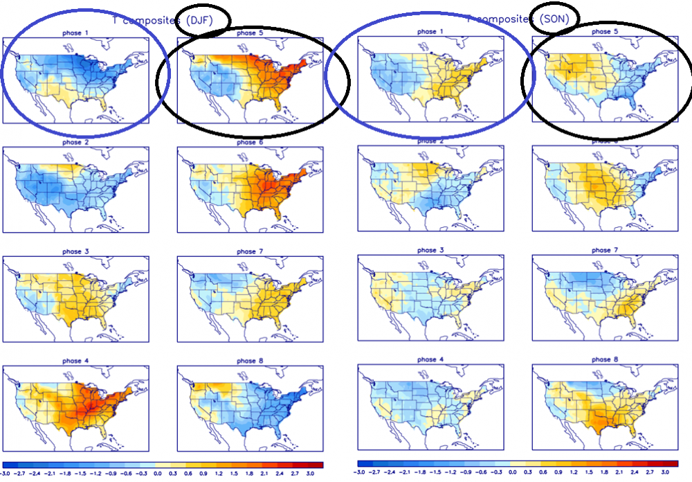
It looks like the mjo heading into phase 8 in early November could mute the warm-up or at least the warm-up won't last as long as guidance suggest. I'm hearing that the mjo may frequently be in Phase 8 1 and 2 this winter instead of the maritime continent don't know if it's going to be a big player this year with such a strong La Nina -
October 2020 General Discussions & Observations Thread
binbisso replied to uofmiami's topic in New York City Metro
The mjo in Phase 5 for most of October didn't have the usual outcome here in the Northeast which is usually much below-normal temperatures. We will finish solidly about normal throughout the region -
remnants of zeta and potential first flakes for some areas
binbisso replied to forkyfork's topic in New York City Metro
Have sleet mixing in with the rain here in Mount Vernon with a temperature of 37 degrees


