binbisso
-
Posts
889 -
Joined
-
Last visited
Content Type
Profiles
Blogs
Forums
American Weather
Media Demo
Store
Gallery
Everything posted by binbisso
-
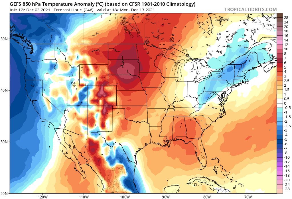
True. However this warm up looks muted may be lasting 5 or 6 days. Probably not wearing shorts and a T-shirt any time this week although from the post you read on here you would think that was gonna happen. the poster from Coney island is saying plus 14 for the next 8 days let's see if that verifies
-
I was specifically talking about our area I could care less what happens in Chicago or Omaha +1.4 in the park through the 1st 10 days of December is not impressive even in the new 30 year Cycle.
-
60S for 6 hours today and probably on Thursday Plus 5 or so for the rest of the week I think people are gonna fail on calling for a record warm December. Edit: Plus probably very little sunshine during this warm up. What a way to run a torch pattern
-
55゚ cloudy foggy and drizzle If this is what a torch means you can have it
-
I know I shouldn't take the bait but are you joking or do you have other reasoning
-
I'm not saying we shouldn't do everything we can to try and reverse climate change However do you think anything's gonna change in the foreseeable future. I don't. Warmer is the new normal that's just the way it is and there's nothing that I on my own can do about it
-
Maybe I'm looking at this incorrectly I don't know. Our climate is warming With greater increments each decade and there's no reason to believe that would stop. This year should end up warmer than last year and the next year warmer than this year. so if a year/decade can end up cooler than the previous year/decade that would surprise me more.
-
Sorry I disagree This is not the 1990s Our climate is warming pretty rapidly and there's no reason to believe it won't continue. I expect warmer than normal temperatures each month and year(esp with 30 year averages) Except in anomalously cold patterns. I'm more impressed with a negative 5 departure than I am with a plus 15.
-
Even this upcoming torch pattern looks Muted. We get plus 10 departures Saturday and next Thursday and only slightly above normal Sunday through Wednesday However Sunday's mean will be skewed with the midnight high Saturday night prior to the frontal passage The same probably happens next Friday. So if guidance is remotely correct 13 of 17 days will average normal and then you will have 4 days at + 10 departures with the cutters due to the unfavorable storm track
-
@bluewave The 1st 10 days were not a warm pattern. It was A unfavorable pattern for snow With 2 cutters which skewed the means. December 2nd and December 6th were plus 9 + 12 at islip the other 8 days averaged below normal.
-
December 2021 Obs/Disco...Dreaming of a White-Weenie Xmas
binbisso replied to 40/70 Benchmark's topic in New England
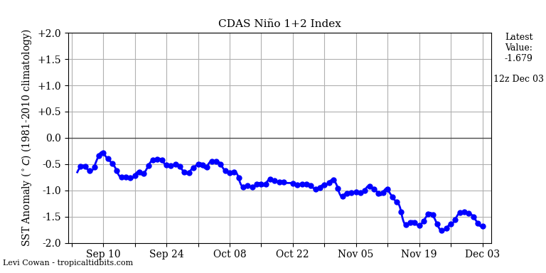
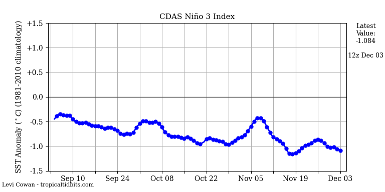
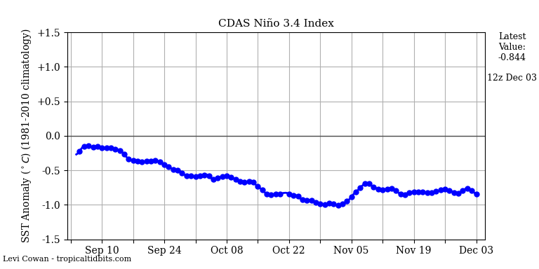
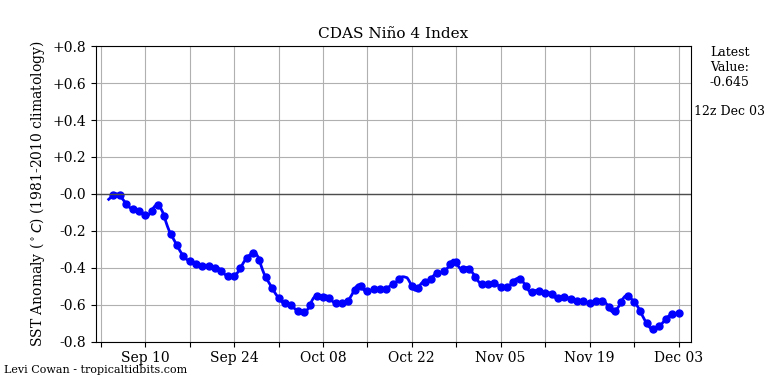
@40/70 Benchmark isn't this nina now east based? These are current surface temps for each region using the tropical tidbit site 4/ -.645 3.4/ -.844 3/ -1.084 1.2/ -1.679. -
Ensembles keep pushing back on this warm up. It's obviously gonna warm up for a bit but But maybe for not so long. The polar vortex on our side of the globe probably has something to do with it. Old run New run
-
It is very interesting. I don't think 2011 2012 type Winter this year. not a wall to wall Winter either as I think those are pretty rare but we should have our opportunities this Winter
-
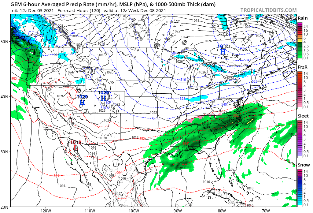
That a pretty impressive 486 1000-500mb dm in Southern quebec which can Do the job to at least get front end accumulating snow even across the coastal plain. To Snowman 19 we don't need a negative NA O to have a light to moderate snowfall here. We did very well between 2010 and 2020 with a mainly positive NAO

-
Very dry lately with down sloping gusty Northwest winds. I've noticed that the models have been too cool with temperatures. Do they factor in down sloping winds and soil moisture into their algorithms?
-
It's solidly East based. What the Implications are I'm not sure. usually East based LA Nina's are better for our area if you like snow and cold
-
I thought this was gonna be a moderate to strong LA Nina. Didnt someone post last week that 3.4 and 4 were gonna fall off sharply? What happened?
-
Today's teles and MJO forecast look better than recent days they now have the MJO going into phase 7 And while the AO/NAO trend positive they look to bring it back to neutral. I know Snowman 19 feels and I agree with him that the MJO will have a tough time getting into favorable phases, however I do think that with The colder temps now established in regions 3 and 1.2 we have a chance to get convection over or near the date line. We shall see
-
A -epo Will usually dump the cold into the central US. Storm track would be to our West with lots of cutters especially with no nao help. It's not the end all be all for Winter forecast.
-
Totally agree. So far the mjo standing wave is weak and other factors seem to be driving the pattern. many forecasted a warm November even up to a week ago and now looks like November will be solidly below normal Probably negative one to negative 2 for CPK. 1st negative 10 departure on Tuesday? More cold coming next weekend.
-
Yeah I realized I read too much into it that's why I edited it. Thanks for your response enjoy reading your Winter forecast each year
-
Using euro MJO guidance it doesn't look to progress out of the COD Until early December when it comes out in either 6 or 7. Assuming it's correct I would hope it would continue to progress into 8 by latter half of December which would be great timing. As far as the strat you can have it. if we're relying on an SSW to save Winter count me out half the time they don't even favor us. Not implying you favor that just stating how I feel. Edit: just keep the spv weak. I'll roll the dice with that
-
Am I missing something here. the MJO is basically in the COD through early December. granted it will be between phases 4 and 6 but will it have any influence on the weather pattern during this time frame? I don't think so. I think other factors will play a bigger role in determining our our sensible weather through at least early to mid December.
-
GEPS also corrected colder day 10+. Back to a western ridge. Looking at the gfs individual members about 12 have an inch or more of snow for nyc on north thru turkey day. Probably not happening but can't be ruled out
-
If guidance is remotely correct we're going to be solidly below normal by the 20th. I don't see most of the area above normal for November except for Newark of course. Sorry had to throw that in there lol