binbisso
-
Posts
889 -
Joined
-
Last visited
Content Type
Profiles
Blogs
Forums
American Weather
Media Demo
Store
Gallery
Everything posted by binbisso
-
I wonder how many days this summer we had a heat index above 95*. I bet the fewest at this point in 12 years
-
Hard to get The dew points above 70゚ even with a strong southerly flow ahead of a cold front. The summer without dews continues.
-
Bluewave and Snowman 19, If this nina is coupled with the atmosphere, Where has the WAR been for the last 6 weeks or so and No sign of it showing up in the next 2 weeks? We have had nina' act like nino's and vice-versa the last several years. I'm skeptical that our sensible weather will follow enso going forward.
-
Not just 95゚ but with dew points in the mid sixties or higher. 95*/50 Is not hot and a great summer day. I'll take that over 80゚/72dp any day
-
With the 15 year average high temperature at Newark of 87.3゚ shouldn't we have a different criteria for heat waves than 90゚ in this warming climate. Especially when dew points are in the forties and fifties with the real feel temperature 5゚ lower Than the actual temperature. It's like comparing 3 consecutive days of 33*, 34* and 35* In early January as a bitter artic outbreak.
-
I think the big story through the 1st half of met summer will be the low dew points. In the mid forties today in July is pretty impressive and we should have many more days the next week or so like today.
-
On his 5 PM update Craig Allen on WCBS radio Reported high temperatures across the area at 5pm were in the mid eighties eighties and then he mentioned Newark which was at 91 at 5 PM. He believes there's a sensor issue at Newark And mentioned it on air today. He's a well respected met doing this for many years and wouldn't say something like that if he didn't believe it to be true.
-
I did notice that Newark was colder in January. Plus you have mentioned that Newark was cooler for a few summers Back in the 2010's. Maybe it is just the pattern Or the micro climate around Newark. It just seems that the last several years when I look at temperatures Newark is always running warmer than all the other reporting stations on the national weather service site
-
Also Harrison New Jersey is 1.8 miles from Newark and they are only at plus 0.5 for the month
-
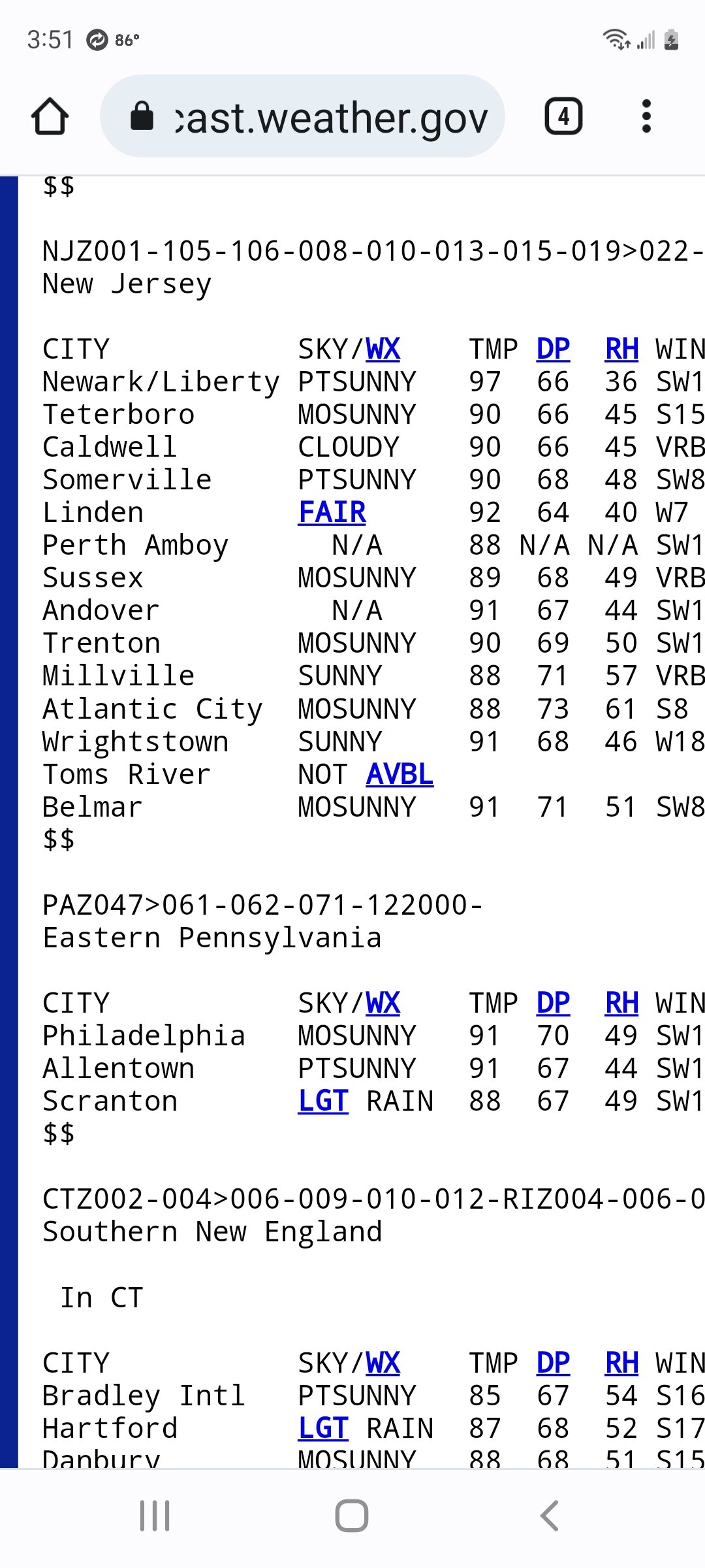
Bluewave This map illustrates perfectly that there is a sensor issue at Newark. According to the map it lies on the border of the light green and yellow which is anywhere from negative one to positive 1 departure yet it came in at plus 1.8. also Trenton and Allentown were closer to the ridge axis as was the rest of Eastern Pennsylvania and they are much cooler than Newark. Also look at this weekend's high temperatures Newark was 4゚ and 3゚ Higher than any other reporting station on Saturday and Sunday respectively. Look at sacrus high temperatures he posted in the 90* day topic.
-
What a glorious weekend! Temps right around 90* with heat indices below actual temperatures. If I'm not mistaken the highest heat index was at Newark yesterday 92*. Not all 90゚ days are the same
-
Just put in my AC units today one of the latest times I've installed. My electricity consumption is down 40% from last year. Keep this weather coming
-
Add^^^ Montauk +1.6 Orient point +3.1
-
With the stiff Northwest wind and lack of sea breeze for the last week Long Island reporting stations seem to be the warmest departures in our area Except for Newark of course. Newark+ 2.7 Caldwell+1 Teterboro-.7 Jfk +1.2 Islip +1.3 Farmingdale +2 Lga-.02 Cpk+.1 Hpn+.7 Bdr+1
-
I'd wait till mid July With no heat waves on guidance To feel like we beat the heat this summer. Plus September can be hot I do agree it doesn't have the same sting as July. Anyway astronomical Spring March 21st through June 20th will end up about negative .5 for New York City Central Park. A cold late March but plenty of beautiful days with very little heat
-
It's interesting that Islip and JFK have more 90゚ days than laguardia so far. I believe JFK was 94 today and Islip broke their record
-
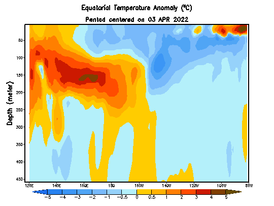
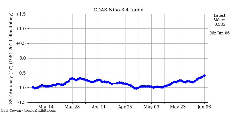
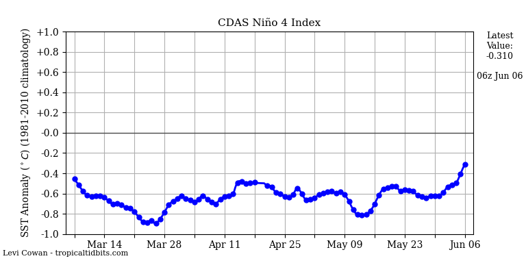
Looks like significant warming taking place in regions 3.4 and 4. Sub surface looks warm as well in those regions. Did we pass the spring barrier yet to try and see what enso state we will be in for the fall and winter? Tried to get current sub surface temps.

-
Bridgeport dropped 24゚ in 40 minutes from 90 at 5:20 PM to 66 at 6 PM. Actually 25 minutes it was 66 at 5:45 PM
-
Still coming down moderatelyRadar looks pretty good Wonder if we can squeeze out an inch with this
-
Yup moderate snow everything covered temperature 28゚ probably gonna get more snow Today which was not forecasted than I did yesterday.
-
Definitely heaviest snowfall rates of the Winter here visibility has to be less than a 1/2 a mile Looking at radar and what has already fallen this easily would have been a warning level snow here if it happened that night or was a few degrees colder
-
Heavy snow Easily 1 to 2" an hour rates right now starting to stick on Paved surfaces closing in on an inch on Coldest surfaces
-
Special Weather Statement National Weather Service New York NY 1000 AM EST Wed Mar 9 2022 CTZ005>012-NYZ068>071-091700- Northern Fairfield-Northern New Haven-Northern Middlesex- Northern New London-Southern Fairfield-Southern New Haven- Southern Middlesex-Southern New London-Putnam-Rockland- Northern Westchester-Southern Westchester- 1000 AM EST Wed Mar 9 2022 ...SNOWFALL RATES PICK UP THROUGH THE MORNING... Snowfall rates will pick up over the next few hours and may become moderate at times reducing visibility to less than a mile. Little to no accumulation is expected on roadways. 1 to 2 inches of snowfall is expected on any untreated surfaces.
-
Yup coating on colder surfaces in Mt Vernon mod snow 32*