crossbowftw3
-
Posts
1,394 -
Joined
-
Last visited
Content Type
Profiles
Blogs
Forums
American Weather
Media Demo
Store
Gallery
Everything posted by crossbowftw3
-
the most unfortunate part of this all remains the idea that SPC hoists potential PDS watches by mid-afternoon, and very little winds up happening until the jet kicks in, lulling people into thinking not much would wind up occuring.
-
The overall background state for sure will allow for significant tornadoes, how many and what magnitude who knows
-
Upstate/Eastern New York
crossbowftw3 replied to BuffaloWeather's topic in Upstate New York/Pennsylvania
rougher timing for Southern New England folks where I believe heavier snows should be. If NAM plays out verbatim it'll be a traffic nightmare there. Here snow should be over by 4-5 AM -
Upstate/Eastern New York
crossbowftw3 replied to BuffaloWeather's topic in Upstate New York/Pennsylvania
gonna guess 1-3 for @sferic and i now that modelling steadily is leaning towards some backside snow for Thursday night now. -
Commutes are gonna be nightmarish if heavy snows are falling right during the AM rush for y'all, here if we see snow at least it's out by 4-5 AM
-
1-3 looks good for us in northern sections of this forum. NE may see some heavy snows right at the worst possible time. The commute could be nightmarish
-
12z Euro raising the possibility of some goodies Thursday Night with temps crashing with possible advisory amounts into NNJ and some 7-8" totals in Massachucetts
-
Euro with a widespread advisory event with some 7-8" across some elevations
-
Here comes trouble. https://www.spc.noaa.gov/products/outlook/day2otlk.html Look at this particular set of words as well

-
It’s pretty much exactly what I’m thinking anyway with 1-2” of snow perhaps possible before we start another potential warmup into next week
-
A thread. From one of SPC's lead forecasters, no less. Conclusion: significant outbreak is growing ever more probable.
-
Day 2 Moderate Risk will be needed at this point across the south. All models today are steadily inching closer to a potentially significant event. This is a nasty sounding.
-
the map you posted in the New England subforum looks like a hint at some LES going across WNY too
-
So to bring things back around for Wednesday’s threat down south: https://twitter.com/NWSSPC/status/1371364187478224897?s=19
-
Upstate/Eastern New York
crossbowftw3 replied to BuffaloWeather's topic in Upstate New York/Pennsylvania
Whatever happens late this week, it’s probably curtains for any truly meaningful snow barring late season LES until October at bare minimum. Let’s make it count -
Dry as a bone this morning making it feel even colder let’s see what happens late week. Quite probably winter’s last dance with respects to any meaningful snow for perhaps the next 7 months
-
Winter’s last dance perhaps. Let’s see what happens
-
I admit that this whole week's potential for some wintry events has been rather hard to follow in part because of the v16's inbound implementation. I don't think this would be more than a minor event regardless.
-
We might see dew points drop to negatives at some point which has to be some kind of record in association with this.
-
Looking potentially interesting for a little topper to our season. I'd lean lower on potential ranges but 1-4" seems like a good bet.
-
If this does become something, are we looking at uniform 10:1 or higher wrt ratios? I understand it's late season but also looking to fall at night. Also looks like it generates a lake response for our friends upstate.
-
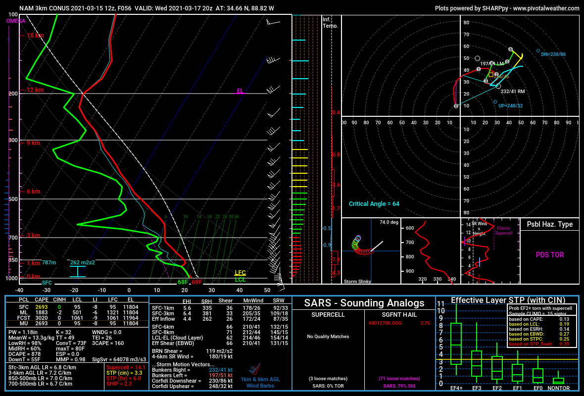
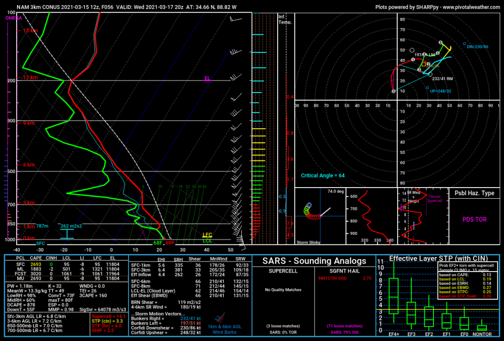
This is a dizzyingly wide warm sector on the NAM
.jpg.59d369ad11e9cf87a12d43bbf2e78f77.jpg)
-
This is a Warm Sector you should be seeing in April or May down south, not March. This is becoming increasingly concerning.
.jpg.aee09349c3c4056b5066bacd61675d2e.jpg)
-
The level of concern I hold for Wednesday's severe event down south is escalating. This wide warm sector could be accompanied by favorable shear, LRs, moderate forcing, and very favorable surface track. This is a warm sector you should be seeing in April or May, not March. This is getting increasingly worrying.
.jpg.c4c2d4cbc9b9454373f36c3167809131.jpg)